This web page describes a section of the Way of the Patriarchs, as seen near the community of Elazar.
 >
>
Home > Sites > Judea > Way of the Patriarchs (Derech HaAvot)
Contents:
Overview
History
Photos
* North Way
* Milestone 12
* Miqveh
* Northward
* Milestone 11
* Lime Kiln
* Climbing Cliff
Drone Video
Etymology
Links
Overview:
This web page describes a section of the Way of the Patriarchs, as seen near the community of Elazar.
Location:
The map shows the points of interest around a section of the ancient Hebron-Jerusalem (“Patriarchs Way”) road.
History:
- Bronze and Iron Ages
* The source of the name of the route:
The primary reason is the route’s association with the biblical Patriarchs—Abraham, Isaac, and Jacob. According to the Book of Genesis, this was the central axis they used to traverse the Land of Canaan.
-
Abraham: Traveled this path when he entered the land from Shechem, moving south to Bethel and then to Hebron and Beer Sheba.
-
Isaac and Jacob: Are described as living and moving between these same mountain-top cities (Hebron and Bethel).
-
The Cave of the Patriarchs: Because the road connects the major holy sites associated with these figures—specifically the Machpelah in Hebron—it became known as their “way.”
The name is also “earned” by the road’s unique geography. In ancient times, traveling through the lowlands or deep valleys was dangerous due to swamps, thick vegetation, and the risk of ambush. The “Way of the Patriarchs” stays on the very crest of the mountain range. By sticking to the high ground, travelers avoided crossing steep ravines (wadis). This made it the most logical, efficient, and dry path for nomadic shepherds (like the Patriarchs) and their herds to move between the central mountain cities.
The cities and roads during the ancient periods, up to the Roman period, are indicated on the Biblical Map below. The Way of the Patriarchs is indicated as a dashed line, connecting Jerusalem to Hebron and farther south to BeerSheba. The area covered in the page , near Beth Zechariah, is marked as a red square.
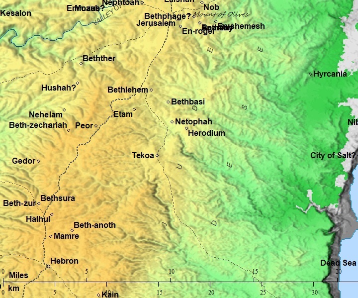
Map of the area – during the Israelite to Roman periods (based on Bible Mapper 3.0)
The map shows that the route is actually more to the east, since during the Bronze/Iron age it passed along the Biar valley, similar to the modern Highway #60. The route of the bypass was (south to north) from Kh. el Qatt (east of Karmei Zur), then kh. Umm et Tala (south west of Migdal Oz), via Rujm es Sabit (modern day Efrat south junction), then passed Peor (aka Khirbet Zakandah, Kh. Faghur, where a large well existed), to Kh. Umm el Qita’ (south of Bethlehem).
According to David Dorsey (“The Roads and Highways of Ancient Israel,” 1991, pp. 119-124), this route was designated as Route ‘N1’— the national highway of the Bronze/Iron periods from Jerusalem to BeerSheba via Hebron.
- Hellenistic period – Major Battles along the route
The Way of the Patriarchs (Derech HaAvot) wasn’t just a biblical path; it was the strategic “spine” of Judea. Because it followed the high watershed ridge, any army attempting to strike Jerusalem from the south was funnelled onto this narrow mountain track.Major battles were conducted between the Greeks and the revolting Maccabbees near the Way of the Patriarches.
The “Way of the Patriarchs” dictated the tactics of both sides: For the Greeks: The ridge was wide enough for their heavy phalanxes and elephants, but it was bordered by steep ravines. They were trapped on the road, unable to deploy their full numbers. For the Maccabees: The surrounding hills provided “exit ramps” for guerrilla warfare. They could strike the Greek columns from the heights and disappear into the caves and valleys (like the Gush Etzion woods).
The Battle of Beit Zur (164 BC) was the fourth major battle of the revolt and arguably the most significant. The Seleucid regent Lysias attempted to bypass the dangerous Gophna hills to the north and instead approached Jerusalem from the south via the Hebron road. Judas Maccabeus intercepted the Greeks at the fortress of Beit Zur (near modern Halhul/Karmei Tzur). Despite being outnumbered, the Maccabees won a decisive victory. This success broke the Seleucid blockade of Jerusalem, allowing the rebels to reach the Temple Mount and rededicate the Altar—the event commemorated by Hanukkah.
The Battle of Beth Zechariah (162 BC) represented the fifth major engagement of the Maccabean Revolt. The Seleucid army, under the leadership of Lysias, utilized a massive force of 50,000 infantry, 5,000 cavalry, and a formidable line of 30 war elephants. Advancing from Beit Zur toward Jerusalem, their objective was clear: march north along the Way of the Patriarchs, crush the rebellion, and seize Jerusalem. According to 1 Maccabees chapter 6, Judas Maccabeus and his brother, Eleazar Avaran, positioned their smaller force of 10,000 to 20,000 men on the strategic heights of Beth Zechariah to intercept them. The ensuing battle was a brutal Seleucid victory, marked by the heroic but tragic death of Elazar during a desperate assault on a war elephant.
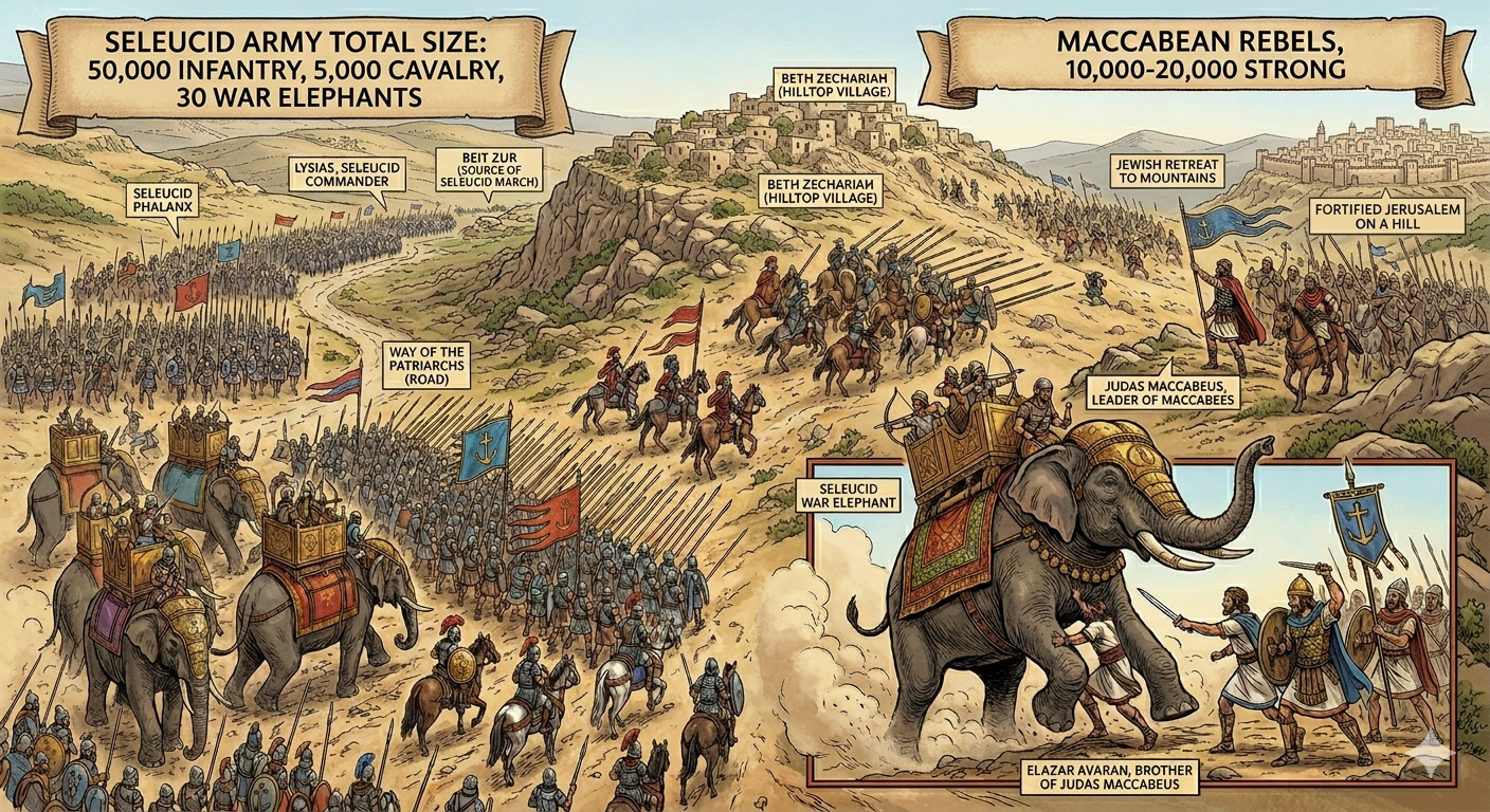
Reconstructed scene of the Battle of Beth Zechariah – AI generated Credit: Gemini AI / BibleWalks Collection
- Hasmonean period (141-37 BC)
Following other battles and peace agreements, the Maccabees were successful in establishing the Hasmonaen Kingdom in 141 BC.
- Roman period
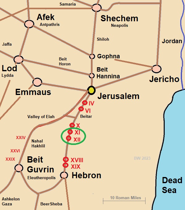
The Roman period route in the area of Gush Ezion was slightly west to the Iron Age period route. In this area there were 3 milestones (from south to North): 12th (XII) – east of Beth Zechariah, south of Elazar, 11th (XI) – north west of Elazar and tenth (X )- East of Neve Daniel. The number indicates the distance in Roman Miles (1 Roman mile = 1480 m, or 0.92 miles) from the starting point in Jerusalem.
The physical milestones visible today were placed during the Roman administration of the 2nd century AD. They were erected during during the reigns of Hadrian (117–138 AD) and Marcus Aurelius (161–180 AD).
The major roads to/from Jerusalem appear on the following illustration. The area that is covered in this web page is marked by a green circle on the section of the road from Jerusalem to Hebron.
-
Ottoman period
Conder and Kitchener of the Palestine Exploration Fund (PEF) surveyed the area during the Survey of Western Palestine (SWP) in 1874-75. This is a section of their map, focusing on the area of Kh. Beit Zekariah (here: Kh. Beit Skaria). Notice the double dashed line of the Roman road to Jerusalem. It follows the the main pilgrimage road of the Roman period that passed on the foothills of Kh. Beit Skaria, marked as Ka’at ez Zeituneh (meaning: “The plain or courtyard of the olive tree”). The other route of the Bronze/Iron age period is seen on the bottom right corner along Wadi el Biar.
Part of map sheets 17/21 of Survey of Western Palestine,
by Conder and Kitchener, 1872-1877.
(Published 1880, reprinted by LifeintheHolyLand.com)
- British Mandate – Independence war
The 1948 defenders using the same topography to protect the road to Jerusalem, mirroring the strategic goals of the Maccabees 2,100 years earlier.
During the battles, Dani Mass established an outpost on Khirbet Beit Zakariyyah. It was initially manned by students, followed by two squads who maintained telephone communication between the kibbutzim of Gush Ezion. On December 12, 1947, the local Arab residents abandoned the village for Artas. On January 14, 1948, the Arab leader Abd al-Qadir al-Husayni ascended to the site with a large number of his fighters but was forced to retreat after suffering heavy casualties. Yehoshua Marx, one of the 3 defenders who fell in the battle, was commemorated by renaming the outpost to Metzudat Yehoshua (Joshua’s Fortress). Trenches were dug at the site, and it was fortified with barbed wire and landmines. In the month of May 1948, the outpost came under heavy fire. Thanks to the six squads manning the post and the arrival of defenders retreating from outposts to the south, the position held until the final surrender of the Bloc.
-
Modern period
Following the 1967 war, the communities of Gush ezion were resettled. As of 2026, the Gush Etzion Regional Council has jurisdiction over 24 officially recognized settlements. The section of the Way of the Patriarchs that is covered here passes along some of them,and signs are marked along the visible sections. A recommended plate to visit the route is around the communitites of Elazar and Daniel.
Photos:
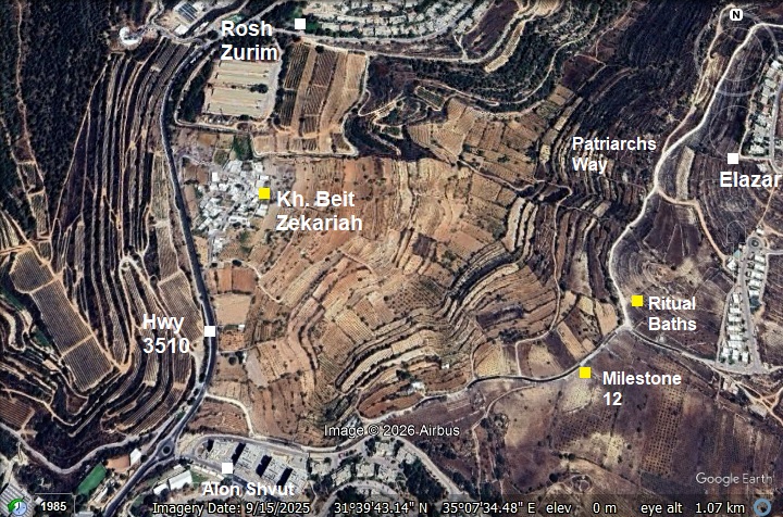
(a) North Way to Jerusalem
The main ancient road to to Jerusalem passed on the valley east and south of Beth Zechariah. This aerial view towards the east shows the path of the ancient road known as the “Patriarches Way”. The primary reason for this name is the route’s association with the biblical Patriarchs—Abraham, Isaac, and Jacob. According to the Book of Genesis, this was the central axis they used to traverse the Land of Canaan. The name is also “earned” by the road’s unique geography. In ancient times, traveling through the lowlands or deep valleys was dangerous due to swamps, thick vegetation, and the risk of ambush. The “Way of the Patriarchs” stays on the very crest of the mountain range. By sticking to the high ground, travelers avoided crossing steep ravines (wadis). This made it the most logical, efficient, and dry path for nomadic shepherds (like the Patriarchs) and their herds to move between the central mountain cities.
Click on the photos to view in higher resolution…
The Romans recognized its strategic value and “upgraded” it from a dirt path to a paved imperial highway, adding milestones that we see today. Just 0.5km down the road is milestone #12 that was erected along the Roman road and marked the 12th Roman miles (17.7 km) from Jerusalem. Another Roman milestone (#11) stands 1.48km to the north.
In the middle of the background, is the community settlement of Elazar, named after the Maccabee hero who was killed during the battle while attacking the war elephant.
On the side of the road are stone markers with the sign “דרך האבות” (Patriarchs way).
(b) Milestone 12
Roman Milestone #12 stands on the side of the road, 0.5 km north of the highway to Beth Zechariah and Rosh Zurim.
After the destruction of the Second Temple (70 AD) and especially following the Bar Kokhba Revolt (132-136 AD), the Romans transformed this dirt track into a paved imperial highway to move legions quickly between Jerusalem (Aelia Capitolina) and Hebron. Most milestones on this specific stretch date to the reign of Emperor Hadrian (117-138).
Roman milestones have a uniform shape of a cylindrical pillar, with an engraved inscription, standing on a square base. While the inscription on this particular stone has been lost to time and erosion, such markers typically served as imperial records. Traditionally, they displayed the distance from the point of origin—in this case, XII Roman miles from Jerusalem—along with a formal dedication crediting the reigning Emperor, the provincial governor, or the specific Roman legion responsible for the road’s construction or renovation.
Since the roads were fixed from time to time, there are could several milestones from different periods. The milestone visible today is one of three markers discovered in this immediate area during the early 20th century.
Below – the current condition of the dirt road on the side of the milestone.
There are no visible remains of the Roman pavement, which may have been either covered over or stolen and reused.
(c) Public ritual bath
Just past the 12th Roman milestone, the landscape reveals a beautifully preserved public ritual bath (miqveh). Positioned along the bustling route to Jerusalem, it served a dual purpose: providing spiritual purification for travelers on pilgrimage and for the local laborers tending the surrounding vineyards.
Most miqva’ot featured a stepped design, allowing individuals to walk down into the water. The steps ensured full immersion, which is essential for ritual purification. This structure features a sophisticated “double-stairway” design. By utilizing separate steps for entry and exit, the “unclean” individual would descend into the water on one side and emerge “purified” on the other, ensuring that the holy and the profane never crossed paths.
The first miqveh installations that have been archaeologically verified date to the late 2nd century BC. This period aligns with the Hasmonean dynasty’s rule in Judea, which saw an emphasis on ritual purity. During the Roman and Byzantine periods, miqveh installations continued to be an integral part of Jewish life in the Land of Israel and beyond. These periods saw significant development in the design, distribution, and cultural importance of miqva’ot.
Inside the miqveh, the steps dive into the immersion pool. Miqva’ot had to be filled with “living water” (mayim hayyim), which comes from natural sources like rainwater, springs, or rivers. This water is considered ritually pure. The miqveh needed to collect and retain this water without it being manually transferred. Rainwater was often collected directly or funneled into the miqveh using specially designed channels. The miqveh had to contain a minimum of about 40 se’ah (approximately 200 gallons or 750 liters) of water to ensure that a person could be fully immersed.
On the walls are ferns (Adiantum capillus-veneris, שערות שולמית מצויות) that benifit from the mositure inside the cave.
The interior surfaces were coated with plaster to create a waterproof seal. Multiple layers of plaster were often applied, with each layer smoothed and tested for leaks. A smooth, plastered surface was easier to clean and less likely to foster algae or microbial growth, which helped maintain water quality.
The plaster used often contained crushed pottery (terra cotta), lime, and sand, forming a hydraulic cement that could harden even under water, making it ideal for aqueducts, cisterns, and reservoirs.
Behind the miqveh are grape vines. According to Jewish tradition, the vine-dressers (workers responsible for producing the wine), and the workers of the olive oil, had to purify themselves in a ritual bath for producing Kosher wine or oil.
(d) Northward
The dirt road continues north along the western foothills of Elazar community.
From the road are views of the valley, and the community of Rosh Zurim.
On the south side of Rosh Zurim is a small arab village of Khirbet Beit Zakariyyah. This was the place of Beth Zechariah where a major battle was conducted during the Maccabee revolt.
(e) Milestone 11
At ~1.4km from the previous marker is milestone 11 (XI).
This milestone stands on its original height as found in the early 20th century.
(f) Lime Kiln
Near the milestone, on the aest side of the road, is a lime kiln. It was used to burn limestone in order to produce Calcium oxide (aka, quicklime or burnt lime). The lime was then used as a sealant to cover the surfaces of the cisterns, thus preserving the water in the reservoirs. It was also used as a key ingredient for making cement.
(g) Cliff of the Patriarchs
Near milestone 11, between Elazar and Neve Daniel, is a cliff climbing site (“Cliff of the Patriarchs”) . The cliff opened for climbers in 2020 by the Gush Etzion Tourism Council, with the support of the Israel Climber’s Association. It is named after Shilo Gal who was the first head of the Gush Etzion regional council.
The cliff is 10m high. A total of 46 climbing routes have been erected on the cliff.
There are also great views of the area.
(h) Flight over the site:
![]() The following YouTube video shows a flight of a drone over the site. The drone views the place of the Beth Zechariah battle field and the hilltop from the south side, then turns toward the Way of the Patriarchs towards Jerusalem.
The following YouTube video shows a flight of a drone over the site. The drone views the place of the Beth Zechariah battle field and the hilltop from the south side, then turns toward the Way of the Patriarchs towards Jerusalem.
Etymology:
- Maccabees (מכבים) – narrowly refers Judas Maccabeus and his four brothers, a group of Jewish rebel warriors who re-took control of Judea. This revolt resulted in the establishment of the independent Hasmonean kingdom.
- Eleazar, Elazar (אלעזר)- Hebrew: “God has helped”.
- Eleazar Avaran – brother of Judas Maccabeus. His nickname Avaran: the “Goad-Sticker”.
Links:
* External:
- Hiking Trails on the cliff of the Patriarchs Gush Etzion toursim
- Route 60: The Biblical highway Doc explores the “Way of the Patriarchs”, CBN News, Friedman & Pompeo; Youtube, 8.5 minutes
* Internal:
BibleWalks.com – walk with us through the sites of the Holy Land
Beth Zechariah<<<—previous Judea site–<<< All Sites >>>—next Judea site—>>> Dir Baal
This page was last updated on Apr 4, 2026 (new page)