Beth Zechariah was the site of a Maccabean battle against the Seleucid army, and is identified at Horvat Beit Zekharya.
 >
>
Home > Sites > Judea > Beth Zechariah
Contents:
Overview
History
Photos
* Beit Zekharya
* Burial Caves
* Western foothills
* South Way
* North Way
* War Elephants
Drone Video
Etymology
Links
Overview:
Beth Zechariah was the site of a Maccabean battle against the Seleucid army, and is identified at Horvat Beit Zekharya. A numismatic survey searched the area around the site to rediscover the area of the battle.
Location:
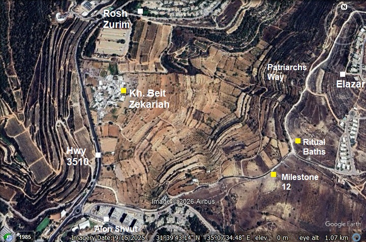
The map shows the points of interest around the Horvat Beit Zekharya – identified as the ruins of Beth Zechariah. This moderate hill is 950m above sea level, about 7km south west of Bethlehem. It overlooked the ancient Hebron-Jerusalem (“Patriarchs Way”) road that passed in the valley 300m south and east of the site.
History:
- Persian period
According to the numismatic survey of the area (Raviv, June 2022), the Jewish village at Beth Zechariah was established during this period. The report suggested that the settlement belonged to Bet Zur, the southermost district of Persian Yehud.
The surveyors found a single rare Philistian Drachm, minted at the late 5th or forth century BC. The silver plated coin shows a helmeted head of Athena on the obverse, and horse and rider on the reverse. This sounds unusual for Persian coinage, as the “official” imperial currency of the Persians featured the Royal Archer. However, the 4th century saw a massive rise in local and provincial “imitative” coinages that featured Athena. The Athenian tetradrachm, featuring the helmeted head of Athena and her owl, was the “US Dollar” of the ancient world. When the supply of genuine Athenian silver dropped after the Peloponnesian War (404 BC), various Persian satrapies and territories began minting their own versions to facilitate trade and pay mercenaries. In the Persian province of Yehud (Judea), the earliest local coins (mid-4th century BC) were tiny silver fractions that directly copied the Athenian design. On these coins, the Greek inscription was replaced with the Paleo-Hebrew letters Y-H-D (יהד). Interestingly, some versions of these coins (such as the one found here) show a “bearded” or male-looking Athena, likely a local artistic reinterpretation or a blend with a local deity.
- Hellenistic period
The village continued to be settled during this period, as attested by a large number of coins (25 out of total 92 coins detected in the survey) and sherds (44% of total sherds). Also, all but one of the 15 burial caves were dated to the Hellenistic period.
- Battle of Beth Zechariah (162 BC)
The Battle of Beth Zechariah (162 BC) represented the fifth major engagement of the Maccabean Revolt. The Seleucid army, under the leadership of Lysias, utilized a massive force of 50,000 infantry, 5,000 cavalry, and a formidable line of 30 war elephants. Advancing from Beit Zur toward Jerusalem, their objective was clear: march north along the Way of the Patriarchs, crush the rebellion, and seize Jerusalem.
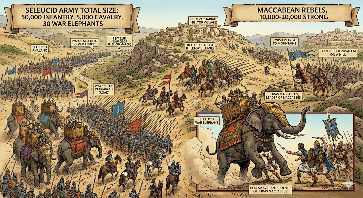
Reconstructed scene of the Battle of Beth Zechariah – AI generated Credit: Gemini AI / BibleWalks Collection
According to 1 Maccabees chapter 6, Judas Maccabeus and his brother, Eleazar Avaran, positioned their smaller force of 10,000 to 20,000 men on the strategic heights of Beth Zechariah to intercept them. The ensuing battle was a brutal Seleucid victory, marked by the heroic but tragic death of Elazar during a desperate assault on a war elephant.
Though the Jewish forces were forced into the mountains and Jerusalem was placed under siege, the Seleucids were ultimately denied a total victory. Political instability in Antioch forced Lysias to abandon the campaign, leading to an unexpected peace treaty rather than a conquest.
Physical evidence of the clash came to light when surveyors, using metal detectors, uncovered three lead sling bullets from the Hellenistic period. These artifacts were discovered on the northwestern foothills, spaced roughly 20–30 meters apart on a single slope. This specific “scatter” of ancient ammunition implies a tactical skirmish or a volley of fire at that exact location, offering a tangible link to the Maccabean-Seleucid struggle at Beth Zechariah.
- Hasmonean period (141-37 BC)
Following other battles and peace agreements, the Maccabees were successful in establishing the Hasmonaen Kingdom in 141 BC. The survey found 37 Hasmonean coins (40% of total coins) and 9% of the total sherds. Several rock hewn tombs of this period were also documented in the survey.
- Early Roman period
According to the numismatic survey of the area (Raviv, June 2022), the Jewish village continued to be settled after the first revolt against the Romans (67-70 AD), but ended after the Bar Kokhbah 2nd revolt (132-136 AD). Like other Jewish villages, the Romans wiped out the village.
- Late Roman period
The numismatic survey indicated some presence at this time, but this could not indicated continuous presence.
- Byzantine to Ottoman period
According to the PEF report, there was probably a Byzantine period church inside the village. The numestic survey of the area showed a spares activity during this period.
-
Ottoman period
The Ottoman period village at Beit Zekariah was established in the 16th century, but at the 2nd half of the 19th century there was little presence in this village.
Conder and Kitchener of the Palestine Exploration Fund (PEF) surveyed the area during the Survey of Western Palestine (SWP) in 1874-75. This is a section of their map, focusing on the area of Kh. Beit Zekariah (here: Kh. Beit Skaria). Notice the double dashed line of the Roman road to Jerusalem – the main pilgrimage road that crossed the valley south of the site.
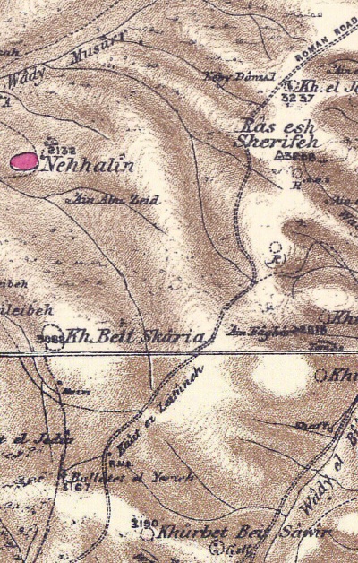
Part of map sheets 17/21 of Survey of Western Palestine,
by Conder and Kitchener, 1872-1877.
(Published 1880, reprinted by LifeintheHolyLand.com)
Their report described the modern village and Byzantine period findings inside the village(Volume 3, pp. 35-36, 108):
“Beth Zacharias (i Mace. vi. 32).—Seventy stadia from Bethzur (Ant. xii. 9, 4), on the way to Jerusalem, is the present ruin of Beit Skaria, the position of which agrees well with Josephus’s account. The place is mentioned also by Willibald (724 a.d.), who distinguishes it from the home of the father of John Baptist (at ‘Ain K a r i m), and places it between St. Matthew (Beit Urmmar, Sheet XXI.) and Jerusalem”.
“Khürbet Beit Skaria —From the main Roman road on the south a path leads to this ruin, situate on the brow, overlooking deep valleys on the east and north. Beside the path is a square foundation about 50 feet side, of roughly-dressed stones. The remains on the hill-brow are those of a large modern village, with more ancient foundations. One wall consists of stones 4 1/2 feet long, 2 feet high, roughly dressed. There is also a mosque, with a portico on the west, sunk below the surface. On the north side of this portico a pillar is placed with a capital of basket-work, like the eighth century Byzantine capitals. The shaft is 2 feet diameter. The mosque door was shut ; perhaps it may represent the site of the church which once stood at this place. Drafted stones with a rough boss were also found, and another capital, apparently Byzantine. To the west of the site are rock- cut tombs, now blocked. A tree grows over the Mukam, or mosque”.
Visited 21st October, 1873.
- British Mandate – Independence war
The 1948 defenders using the same topography to protect the road to Jerusalem, mirroring the strategic goals of the Maccabees 2,100 years earlier.
During the battles, Dani Mass established an outpost on Khirbet Beit Zakariyyah. It was initially manned by students, followed by two squads who maintained telephone communication between the kibbutzim of Gush Ezion. On December 12, 1947, the local Arab residents abandoned the village for Artas. On January 14, 1948, the Arab leader Abd al-Qadir al-Husayni ascended to the site with a large number of his fighters but was forced to retreat after suffering heavy casualties. Yehoshua Marx, one of the 3 defenders who fell in the battle, was commemorated by renaming the outpost to Metzudat Yehoshua (Joshua’s Fortress). Trenches were dug at the site, and it was fortified with barbed wire and landmines. In the month of May 1948, the outpost came under heavy fire. Thanks to the six squads manning the post and the arrival of defenders retreating from outposts to the south, the position held until the final surrender of the Bloc.
Today, a small Arab village exists at the site, with most of its residents employed by the Yeshiva or within the community of Alon Shvut.
-
Modern period
A survey of the area of Horvat Beit Zekharya was conducted in 2022 by a team headed by Dr. Dvir Raviv, with the participation of BibleWalks. The survey employed metal detectors to comb the surface of the northern and western slopes of the hill, and the location of each coin was documented. The team also dated the pottery sherds that were discovered within 10 designated polygons.
Photos:
(a) Horvat Beit Zekharya
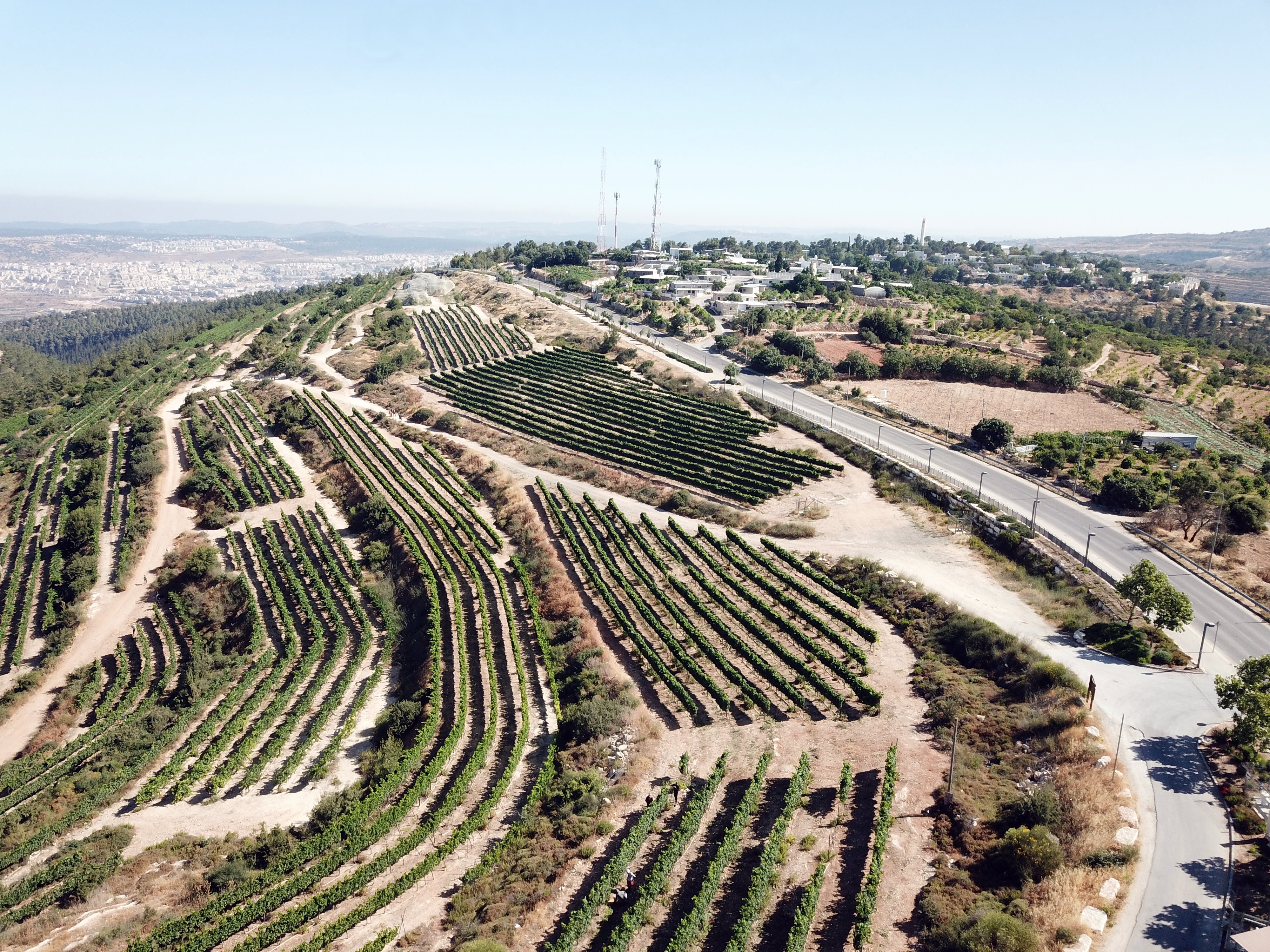
The ruins of Beth Zechariah are located on a moderate hill, 950m above sea level. This is a view towards the south west. The small white buildings on top of the hill are the Palestinian village of Khirbet Beit Zakariyyah that was built over the ruins of Hellensitc/Roman period village (Beth Zechariah).
In the far right background, 1km north east of Khirbet Beit Zakariyyah, is the Jewish community of Rosh Tzurim, one of the communities of Gush Ezion.
Click on the photos to view in higher resolution…
Next is a south view of the site. The survey team scanned these foothills along the modern road to Rosh Zurim.
The ancient road passed along the valley on the bottom of the view, turning around to the south.
(b) Burial Caves
Several burial caves were documented by the survey team. All the 15 rock hewn caves were found on the western foothill.
This aerial view shows a line of tombs along the peripheral road of Beit Zekharya.
This is one of the rock-cut burial caves.
According to Dvir Raviv who headed the survey, “all but one of the caves feature squre burial chambers with surrounding chambers around a central standing pit” and that dates the caves to the Hellenistic period.
The cave is full of trashed books and papers. Probably it was used as an archive during modern period.
Another burial cave was seen on the south west side of the ancient village, just above the valley.
(c) Western foothills
The ruins of ancient Beit Zekharya are located on the hill seen here where the building of the Palestinian village of Khirbet Beit Zakariyyah are now located on top of the hill. This modern road (#3510) ascends the hill and continues to Rosh Tzurim.
A herd of goats moving along a rocky terrace offers a scene remarkably unchanged since Biblical times. In the rugged landscape of Judea and Samaria, goat herding remains a deeply rooted and strategically significant pursuit for both Jewish settlers and Palestinian residents. Beyond its role in establishing a physical presence on the land, the practice provides a low-overhead, sustainable income stream. By converting the region’s hardy natural scrub into high-value artisan cheeses and organic milk, herders turn the challenging terrain into a productive economic asset.
In the area south of the site are hewn rocks, a part of an ancient quarry.
Our survey also scanned the edge of the valley on the south west side of the site.
A horse ranch is located here and these riders took a ride down the valley.
(d) South Way to Beit Zur
The main ancient road to Beit Zur and Hebron passed on the valley east and south of Beth Zechariah. This aerial view towards the west shows the hill of Beth Zechariah and the valley that crosses its south and east foothills.
This was an excellent place to set up an ambush to the Greek army marching along the road. This illustration shows the valley on the left side, and Beth Zechariah on a hill overlooking the valley.
The next aerial view, looking north, shows a valley that continued south to Beit Zur and Hebron. Beth Zechariah is positioned at the north end of the valley, just where the road turns right (north), turning around the community settlement of Alon Shvut.
Beth Zechariah is marked on the photo, as well as the path of the ancient road.
Next – a south view of the valley towards Beit Zur, which is located on top of the mountain in the far background, 8km to the south.
Our survey team also scanned this area along the valley. On the left (east) side of the valley is the “Russian hill”, where a Russian monastery was constructed in 1903. On the right (west) side is Kfar Ezion, one of the communities in the Jewish area of Gush Ezion.
Beit Zur (“house of rock”) is where the Seleucid army was positioned prior to the battle. It is located 8km south of Beth Zechariah, at a ruin named Khirbet et-Tubeiqa. This is a high, isolated plateau reaching an elevation of 1,007 meters (3,304 feet) above sea level, making it one of the highest points in the region. This hill is on the north west side of Halhul, 2km south of Carmei Zur. This was previously a southern frontier post of Judea, guarding against the Idumeans to the south. Because it sat directly on the watershed route, any army marching from the south toward Jerusalem was forced to contend with this stronghold. Judas Maccabeus won a major victory here against the Seleucid general Lysias (164 BC). Following this win, the Maccabees fortified Beit Zur to protect the southern flank of Judea, which eventually allowed them to reclaim and rededicate the Temple in Jerusalem (the origin of Hanukkah). However, the Greeks regained control of the fortress in 162 BC, and used it as a staging ground for their massive campaign involving 30 war elephants.
(e) North Way to Jerusalem
The main ancient road to to Jerusalem passed on the valley east and south of Beth Zechariah. This aerial view towards the east shows the path of the ancient road known as the “Patriarches Way”. The primary reason for this name is the route’s association with the biblical Patriarchs—Abraham, Isaac, and Jacob. According to the Book of Genesis, this was the central axis they used to traverse the Land of Canaan. The name is also “earned” by the road’s unique geography. In ancient times, traveling through the lowlands or deep valleys was dangerous due to swamps, thick vegetation, and the risk of ambush. The “Way of the Patriarchs” stays on the very crest of the mountain range. By sticking to the high ground, travelers avoided crossing steep ravines (wadis). This made it the most logical, efficient, and dry path for nomadic shepherds (like the Patriarchs) and their herds to move between the central mountain cities.
The Romans recognized its strategic value and “upgraded” it from a dirt path to a paved imperial highway, adding milestones that we see today. Just 0.5km down the road is milestone #12 that was erected along the Roman road and marked the 12th Roman miles (17.7 km) from Jerusalem. Another Roman milestone (#11) stands 1.48km to the north.
In the middle of the background, is the community settlement of Elazar, named after the Maccabee hero who was killed during the battle while attacking the war elephant.
Below is Roman Milestone #12 as it stands on the side of the road.
During the Battle of Beth Zechariah, there were no Roman milestones. The armies navigated by natural landmarks and the ancient ridge route. After the destruction of the Second Temple (70 AD) and especially following the Bar Kokhba Revolt (132-136 AD), the Romans transformed this dirt track into a paved imperial highway to move legions quickly between Jerusalem (Aelia Capitolina) and Hebron. Most milestones on this specific stretch date to the reign of Emperor Hadrian (117-138). The inscriptions usually credited the Emperor and the governor for the road’s construction.
Just past the 12th Roman milestone, the landscape reveals a beautifully preserved public ritual bath (miqveh). Positioned along the bustling route to Jerusalem, it served a dual purpose: providing spiritual purification for travelers on pilgrimage and for the local laborers tending the surrounding vineyards. The structure features a sophisticated “double-stairway” design. By utilizing separate steps for entry and exit, the “unclean” individual would descend into the water on one side and emerge “purified” on the other, ensuring that the holy and the profane never crossed paths.
![]() Visit the sites along this route.
Visit the sites along this route.
(f) War Elephants
The introduction of war elephants to the Judean hills was the ancient equivalent of a “technological shock.” For the Maccabean infantry, who were primarily guerrilla fighters accustomed to light mobility, these animals were terrifying, near-impregnable moving fortresses. The war elephants during the ancient times were equivalent to modern tanks is highly accurate for several reasons:
-
The elephants were often draped in chainmail or thick leather armor. On their backs, they carried wooden towers (howdahs) protected by shields, housing 3–4 archers or pikemen who could fire down onto the Jewish lines.
-
Most of the Maccabean soldiers had never seen an elephant. The sheer size, the trumpeting sound, and the smell (which often panicked horses) created a “terror factor” that could break a front line before physical contact was even made.
-
Just as a tank division is used to punch through enemy lines, the Seleucids used the 30 elephants to trample the Maccabean infantry, clearing a path for the 50,000 phalanx soldiers behind them.
P/O reconstructed scene of the Battle of Beth Zechariah – Credit: Gemini AI / BibleWalks Collection
Elazar’s Heroic Sacrifice
The story of Elazar Avaran (the “Goad-Sticker”) is one of the most famous tactical accounts of the revolt. According to the First Book of Maccabees, Elazar noticed one elephant that was more ornamately armored than the others, wearing the royal crest. Believing the Seleucid King or the commander Lysias was atop it, he launched a suicide mission.
- He hacked his way through the surrounding infantry to reach the beast.
-
Knowing the armor protected the top and sides, he crawled underneath the elephant—the only soft spot—and stabbed it in the belly with his spear.
-
The massive animal collapsed instantly, crushing Elazar beneath its weight.
While Elazar’s bravery became a legendary symbol of Jewish resistance, the tactical reality was grim. His death highlighted the asymmetric nature of the battle:
-
The Maccabees lacked heavy ballistae (large crossbows) or specialized “elephant-traps” used by more established Roman or Greek armies.
-
Despite Elazar’s success in killing one elephant, the other 29 continued their advance. The sheer mass of the Seleucid force, combined with these “war machines,” forced the Jewish rebels to abandon the open battlefield and retreat to the safety of the mountains.
On the light side: Search of the War elephant
We “tried” to find the elephant that killed Elazar, and we did find on the hillside a toy elephant….
(g) Flight over the site:
![]() The following YouTube video shows a flight of a drone over the site. The drone views the place of the battle field and the hilltop from the south side, then turns toward the Way of the Patriarchs towards Jerusalem. In the second part the view is towards the south where the battle was fought between the armies.
The following YouTube video shows a flight of a drone over the site. The drone views the place of the battle field and the hilltop from the south side, then turns toward the Way of the Patriarchs towards Jerusalem. In the second part the view is towards the south where the battle was fought between the armies.
Etymology:
-
Zechariah (זכריה)– In Hebrew: God will remember him. (Zechar – remember; Iah – God).
- Beit Zechariah, Beth Zechariah (בית זכריה)- The name of the Hellenistic/Roman village. In Hebrew: The house of Zechariah.
- Maccabees (מכבים) – narrowly refers Judas Maccabeus and his four brothers, a group of Jewish rebel warriors who re-took control of Judea. This revolt resulted in the establishment of the independent Hasmonean kingdom.
- Eleazar, Elazar (אלעזר)- Hebrew: “God has helped”.
- Eleazar Avaran – brother of Judas Maccabeus. His nickname Avaran: the “Goad-Sticker”.
Links:
* External:
- 1 Maccabees 6:28–47; Ant. 12:9; Wars 1.41-46
- The Geographical Distribution of Mattatya (Mattathias) Antigonos’ Coins: New Insights from Recent Discoveries – Dvir Raviv, Yaniv Levy; Israel Numismatic Research; Volume 20 2025 pp 145-182
- A Numismatic Survey at Ḥorbat Bet Zekharya and Possible Evidence for the Fifth Battle of Judah Maccabi -Dvir Raviv, Israel Numismatic Research; Volume 20 2025 pp. 85-118; Our photo on page 86.
- Kh. Beit Sikariya – British mandate, IAA archives
- Metzudat Yehoshua Mate Yehuda regional council, Gal Ed, Khirbet Zechariah (Hebrew)
* Internal:
BibleWalks.com – walk with us through the sites of the Holy Land
Biar Tunnel<<<—previous Judea site–<<< All Sites >>>—next Judea site—>>> Way of the Patriarchs
This page was last updated on Apr 2, 2026 (add 1948 events)