Tel Haror – Ruins of a multi-period massive Biblical city. A possible identification is Gerar, an important royal city in the age of the Patriarchs.
Home > Sites > Shephela > Tel Haror (Gerar?)
Contents:
Background
Location
Photos
* North West
* North East
* North East
* Flight over
Biblical
Etymology
Links
Background:
Tel Haror, also known as Tell Abu Hureirah, is an archaeological site located on the northern bank of Nahal Gerar (Wady esh Sheriah) in the low lands of southern Israel. The site has a long and complex history that spans several millennia.
The earliest evidence of human habitation at Tel Haror dates back to the Chalcolithic period (4500-3500 BC), when a small village was established on the site. The village was likely part of a larger network of settlements that developed in the region during this time.
During the Bronze Age (3000-1200 BC), Tel Haror grew into a significant urban center. The city was surrounded by a massive wall and contained a palace, temples, and other public buildings. The city’s economy was based on agriculture, trade, and craft production, and it appears to have been a major center of regional power and influence. This was one of the largest Middle Bronze II city in Southern Canaan.
Scholars identify the site as Canaanite city of Gerar, although there are other candidates for the city (such as Tel Sera). Abraham stayed in Gerar, his wife Sarah was taken then released by the king of Gerar. Genesis 20:2: “And Abraham said of Sarah his wife, She is my sister: and Abimelech king of Gerar sent, and took Sarah…”.
In the Iron Age (1200-586 BC), Tel Haror continued to thrive as an important city. The city was part of the kingdom of Judah and played a key role in the region’s political and economic landscape. It was likely an important center of trade, especially for luxury goods like spices, textiles, and precious metals.
After the Babylonian conquest of Judah (586 BC), the city was abandoned and remained uninhabited for several centuries. In the Byzantine period (4th-7th centuries AD), the site was briefly reoccupied, and a small settlement was established on the ruins of the ancient city.
In summary, Tel Haror is a significant archaeological site that has played an important role in the history of the Negev desert and the wider region. Its complex history provides a window into the economic, political, and social dynamics of ancient societies in southern Israel.
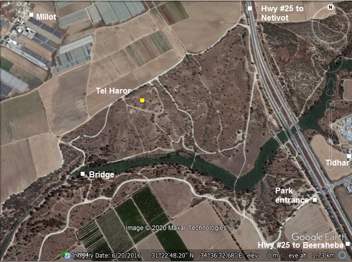
Location:
The site is located in Nahal Gerar park, south of Netivot. Access is from highway #25 west of Moshav Tidhar. After entering into the park, drive west to cross the bridge over Nahal Gerar, then drive to Tel Haror.
History:
- Chalcolithic period (4,500 – 3,150BC)
The lower city was first settled in this period, and continued through the Early and Middle Bronze periods.
-
Middle Bronze Age II (1,750-1,650 BC)
This was one of the largest Middle Bronze cities in Southern Canaan. The Canaanite city reached a peak during this period, spreading over a large area (150 dunam, 15 hectares or 37 acres) on the lower city. The excavators dated findings of this period in the main areas on the mound (K, L, B).
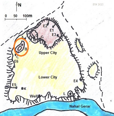
A map of the site is shown here, with indications of the excavation areas. The mound consists of the large (150 dunam) lower city, and a smaller (15 dunam) shaped mound on top of it on the north side. The upper city is diamond shaped, with edges 100m long.
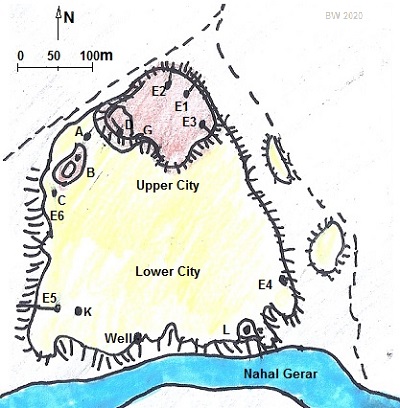 Map of Tel Haror, with Excavation areas
The city was first fortified with ramparts of raised earth. After some time, the earthworks were replaced by massive brick walls.
Special findings included a series of 2 ritual temples in area K (K3 and K4 – one on top of the other). This was the only ritual structure found to date in the southern Canaan. Another interesting finding was an ancient well located to the east of area K and at a lower height, consisting of a circle of large stones.
The city was abandoned at the end of the Middle Bronze period for an unknown reason, but not due to a fierce destruction.
- Biblical event:
The period of Middle Bronze II coincides with the age of the Patriarchs. Gerar was an important royal city at that time on the southern fringes of Canaan. The valley of Gerar was depicted by the Bible as a pasture land. The Bible recorded many events in the lifetime of Abraham and Isaac, who came here with their flocks in the hard years of drought. Genesis chapter 20 tells about Abraham’s stop in the city of Gerar (Genesis 20:1):
“And Abraham journeyed from thence toward the south country, and dwelled between Kadesh and Shur, and sojourned in Gerar”.
Abraham claims that his beautiful wife, Sarah, is actually his sister. This was to avoid a situation that the King will kill him to take his wife. A similar event happened in Egypt (Genesis 12:10-20). The King of Gerar, Abimelech (Hebrew: “my father is king”), indeed takes in his wife Sarah.
Genesis 20:2:
“And Abraham said of Sarah his wife, She is my sister: and Abimelech king of Gerar sent, and took Sarah…”.
God warns Abimelech in his sleep that Sarah was actually Abraham’s wife:
“But God came to Abimelech in a dream by night, and said to him, Behold, thou art but a dead man, for the woman which thou hast taken; for she is a man’s wife”.
Abimelech is frightened, and returns Sarah to Abraham:
“And Abimelech took sheep, and oxen, and menservants, and womenservants, and gave them unto Abraham, and restored him Sarah his wife”.
In this painting – Abimelech, King of Gerar, returns Sarah to Abraham.
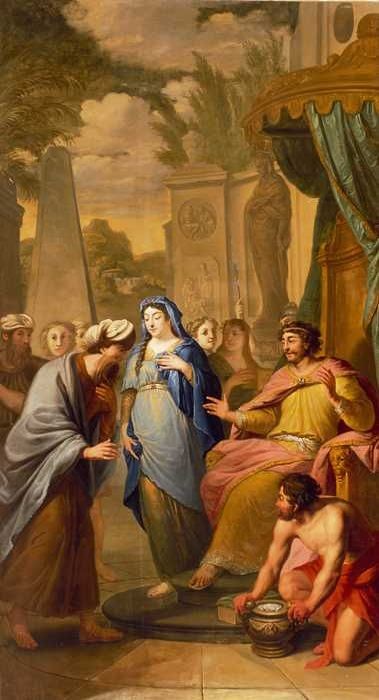 Painting by Elias van Nijmegen (1667-1755) Public domain; Date 1731.
Rotterdam museum https://museumrotterdam.nl/collectie/item/11096
An exactly the same incident happened with Abraham’s son, Isaac. Genesis 26 1, 6-8:
“And there was a famine in the land, beside the first famine that was in the days of Abraham. And Isaac went unto Abimelech king of the Philistines unto Gerar…
And Isaac dwelt in Gerar: And the men of the place asked him of his wife; and he said, She is my sister: for he feared to say, She is my wife; lest, said he, the men of the place should kill me for Rebekah; because she was fair to look upon. And it came to pass, when he had been there a long time, that Abimelech king of the Philistines looked out at a window, and saw, and, behold, Isaac was sporting with Rebekah his wife”.
Abimelech, probably the son of Abraham’s king, returned his wife Rebekah, and Isaac left the city to dwell in the valley of Gerar (Genesis 26:17): “And Isaac departed thence, and pitched his tent in the valley of Gerar, and dwelt there”.
Another incident occurred in the valley of Gerar, when Isaac dug wells and was chased by the herdsmen of Gerar, just like what happened during his father’s times.
- Late Bronze period (1,550 – 1,200 BC)
During this period a smaller city (area of only 4 Dunams) centered around the south east section of the lower city, around area L that is close to Nahal Gerar and the spring.
- Iron Age I – Philistine settlement (1,200 – 1,000 BC)
During this period, the settlement has reduced in size (to merely 2-3 Dunam). It centered in the north west area, around site B, marked in orange. This may have been a fortress. Ceramics were identified as Philistine.
In the 12th century the Philistines arrived to the cities along the shore. The Philistines – “Sea Peoples” from the Aegean sea – landed in Canaan and Egypt in the 12th century BC. The Egyptians fought the invaders (Ramses III battle of 1175 BC) and repulsed them into a small enclave in the southern coastal cities of Canaan (from Gaza to Ashkelon), as per (Joshua 13, 3): “…five lords of the Philistines; the Gazathites, and the Ashdothites, the Eshkalonites, the Gittites, and the Ekronites”.
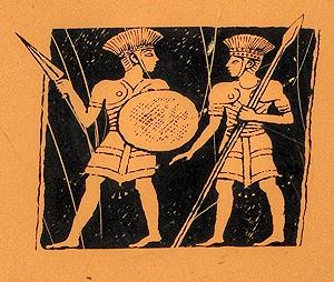
Philistine warriors – on sign of the Zafit national park
The main cities of the Philistines were located in the south coast area named by the Bible as “Pleshet”. The area was initially between Gaza and Ashdod. As described in the Bible (1 Samuel 6:17):
“And these are the golden emerods which the Philistines returned for a trespass offering unto the LORD; for Ashdod one, for Gaza one, for Askelon one, for Gath one, for Ekron one”.
A map of the cities and roads of the Bronze and Iron Age periods is here, with Gerar marked as a red point in the center. In ancient times, a major road passed near the city, connecting Gaza to Beersheba in a short line, although it is not marked here.
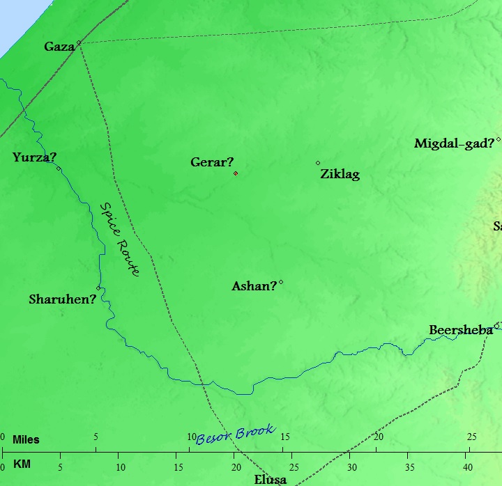
Cities and roads around Gerar) – during the Canaanite, Israelite periods up to the Hellenistic period – Bible Mapper 3.0
Gerar is also mentioned in the pursuit of Asa King of Judea after Zerah the Ethiopian and his 1,000 troops (2 Chronicles 14:13): “And Asa and the people that were with him pursued them unto Gerar”. Asa, the third king of Judah, reigned at c. 911 – 870 BC.
- Late Iron Age II b – Assyrian stronghold (900-700 BC)
During the 8th century Gerar was centered on the north east upper city, on areas D, E and G, as in this illustration (marked in orange). A massive 8th century fortress was constructed on the mound, with walls (4m wide), retaining walls, glacis and towers.
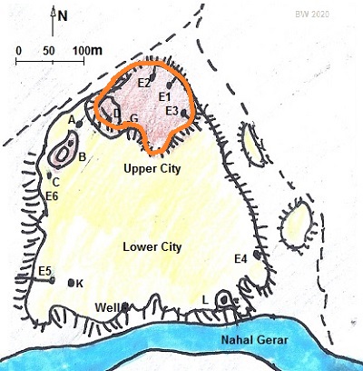
One of the excavated structures was a corner tower. It was built on the corner of the mound, 9m wide, projecting 7m outside the line of the wall. In area G they unearthed a large storehouse, adjacent to the massive wall of the fortress, was unearthed. These halls were 2.55m wide by 6.65m long, aligned with the wall. Similar Iron Age storehouses can be found in other sites such as Tel BeerSheba.
This construction was attributed to the Assyrians. It was part of their southern defense line against Egypt. The fortress was interconnected with the nearby fortifications at Tel Ser’a (Ziklag?) and Tel Gamma (Yurza?). Note that Tel Haror was both older and larger than both of these cities.
The Assyrian empire conquered the North Kingdom of Israel in 732 BC, destroying most of the cities and villages in the land. The Assyrian King Tiglath-Pileser III annexed the area (as per 2 Kings 15: 29): “In the days of Pekah king of Israel came Tiglathpileser king of Assyria, and took … and carried them captive to Assyria”). The Assyrians reached the south coast and made the Philistine cities – from Jaffa to Raphia – a kingdom subdued and raising taxes to the Assyrians.
Due to the heavy taxes, the cities of the Levant attempted to free themselves from the Assyrians. They were assisted by the Egyptians, the empire from the south. Ashdod’s king, Azuri, stopped to deliver tributes to Assyria. The Assyrians replaced him with his brother, but a commoner named Yamani took the power and refused to pay.
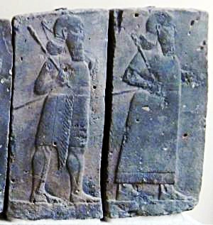
Orthostat relief – depicting soldiers from different orders of the Assyrian Army,
in procession; basalt; Hadatu Tiglath-Pileser III period (744-727BC)
[Istanbul Archaeological museum]
Sargon II ‘s intrusion: The Assyrian King Sargon II (722- 705BC) came to settle the Philistine mutiny. The first step was to handle the allies of the Philistines: in 720 BC Sargon fought the Egyptian army in Raphia, south of Gaza, and managed to repel them back to the south. The next step was to handle the rebel Philistines: in 712 Sargon’s army crushed their cities (Gibton, Ekron and Gath), then took Ashdod and its port city Ashdod-Yam (Ashdudimmu). Prophet Isaiah writes about this campaign, when Tartan – chief officer of Sargon – conquered Ashdod and its seaport (Isaiah 20 1): “In the year that Tartan came unto Ashdod, (when Sargon the king of Assyria sent him,) and fought against Ashdod, and took it”. Isaiah’s prophecy was backed by Sargon’s own accounts of the events, as inscribed in his palace of Khorsabad (discovered by P. E. Botta in 1845). One fragment described the mutiny and specifically mentioned Ashdudimmu (Ashdod-Maritime): “Ashdod, Gath, Ashdudimmu, I besieged, I conquered”.
After the Sargon II destruction, the Assyrians deported some of the Philistine population, replacing them with newcomers.
Sennacherib’s intrusion (701 BC): Following the death of the Assyrian King Sargon II, the Judean King Hezekiah mutinied against the Assyrians, joining other cities in the area in another attempt to free themselves from the Assyrian conquest. Two Philistine cities joined Hezekiah’s mutiny: Ashkelon and Ekron. Hezekiah crushed the other Philistine cities that refused to join the mutiny (2 Kings 18:8): “He smote the Philistines, even unto Gaza, and the borders thereof, from the tower of the watchmen to the fenced city”. The sons of Simeon also invaded the southern parts, probably including Gerar.
The Assyrian army came in 701, led by Sennacherib son of Sargon II (2 Chronicles 32 1): “After these things, and the establishment thereof, Sennacherib king of Assyria came, and entered into Judah, and encamped against the fenced cities, and thought to win them for himself”. The Assyrians first handled the rebelling Philistine cities and then confronted the Egyptian army that supported the mutiny.
The city (level G3) was destroyed by fire after a fierce battle, with a destruction level of more than 1m found in most of the excavation areas.
The Assyrians ruled the area for 100 years, and were followed by the Babylonian empire (630-538 BC) and the Persians (538-332 BC). A destruction level (G2) was dated to the end of the 7th century or beginning of the 6th century, probably due to the Babylonian conquest.
-
Persian (6th – 4th Century BC)
The Persian empire replaced the Babylonians in 538 BC. During the Persian period, the former cities of the Philistines were resettled by the Phoenicians. This ended the 600 years of the Philistine presence in Israel.
At this time was a large and newly organized settlement in the city. Findings from this period were found in area D, G (level G1), and E on top of the Assyrian fortress.
At the end of this period the settlement ceased forever.
- Roman/Byzantine period (1st century BC – 7th century AD)
Eusebius Pamphili (better known as Eusebius of Caesarea), a 4th Century Greek historian of the Church, wrote in his book “Onomasticon” about sites in the Holy Land, including Gerar (translation):
“The Geraritike is now called after this, (the region) beyond the Daroma. Twenty-five miles south of Eleutheropolis. It is the old southern boundary of the Chanaanites and a royal city of the Philistines (metropolis of Palestine). It is located, as Scripture affirms, “between Cades and Sur” (i.e., between) two deserts. The one adjoins Egypt whence the people came having come through the (straits of the) Red Sea. The other (true) Cades extends up to the desert of the Saracens”.
On the Madaba map, a 6th century AD mosaic floor with an illustration of sites in the Holy Land, there is an icon bearing the name “Gerara” in Greek. Under the icon is an inscription quoting the Onomasticon of Eusebius.
![]()
No remains of this period were found on the mound, but there could be a settlement of this period nearby or along the Gerar valley.
-
Ottoman period (1516-1918)
Conder and Kitchener surveyed this area during the Survey of Western Palestine (SWP) of the PEF in 1873. A section of the survey’s map, part of Sheet 24, is shown here, with Tell Abu Hareirah in the center. Notice the road passing near the site, crossing the stream (Nahal Gerar – Wady esh Sheriah). It connected Gaza on the north west to Beersheba on the south east.
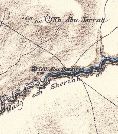
Part of map Sheet 24 of Survey of Western Palestine,
by Conder and Kitchener, 1872-1877.
(Published 1880, reprinted by LifeintheHolyLand.com)
Their report (Volume 3, sheet XXIV) was as follows:
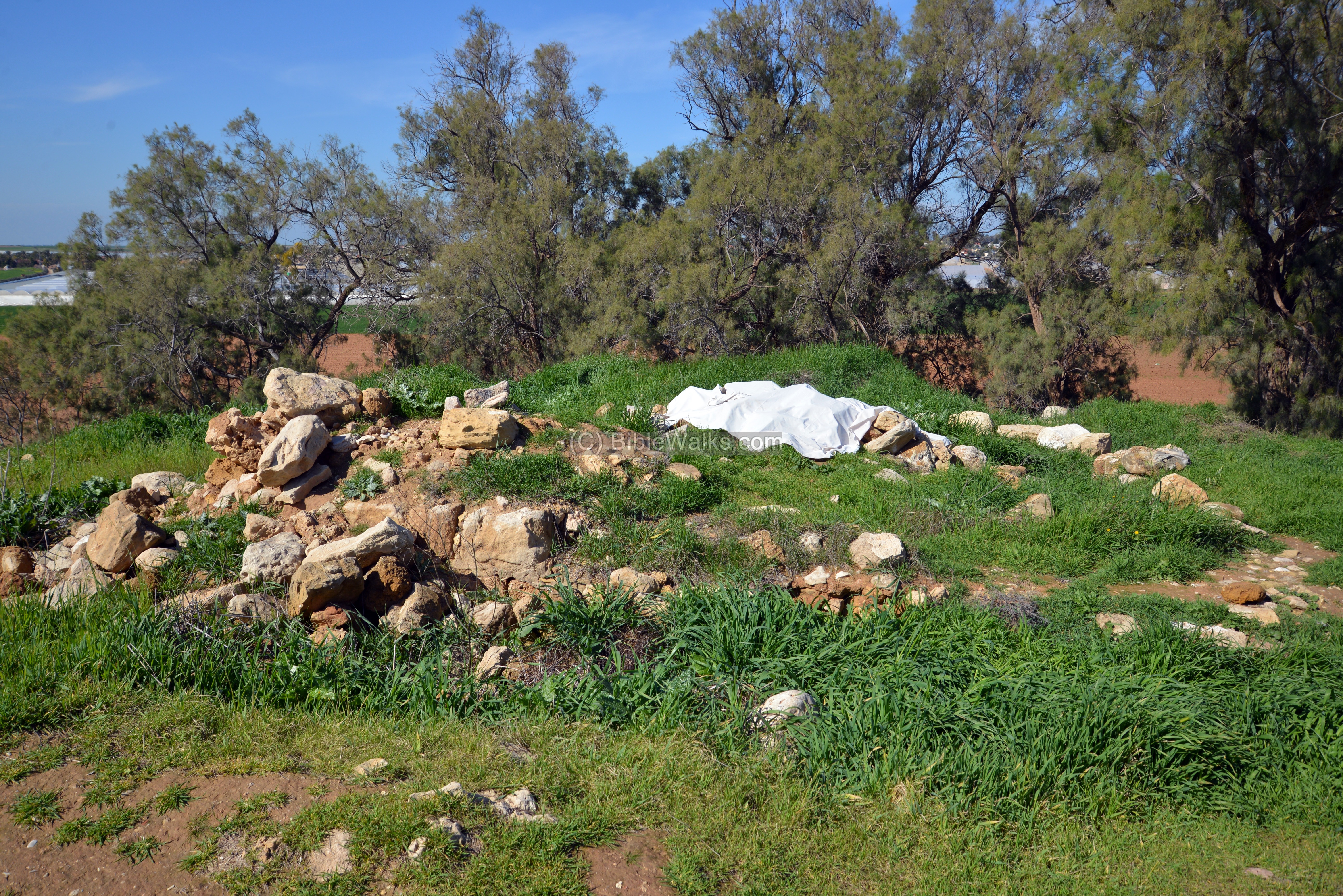
“Tell Abu Hareireh – A large Tell on the north bank of the valley. It is a mound without traces of masonry. There is a sacred building on the top, with a few scattered stones round it, and a great deal of broken pottery. There is a tomb of the Sheikh inside; the building covered with a cloth, and decorated with rags and votive offerings. Abu Hareireh was one of the companions of the Prophet.”.
The other site seen in this section north of the Tel is merely a ruined modern village:
“Khirbet Abu Jerrah (E x).—A modern ruined village of fifteen or twenty houses ; several ruined cisterns of masonry. The houses were of stone and mud”.
- World War 1
During World War 1 the Turkish army cut deep (1.5m) trenches on the mound. This damaged the antiquities on the high mound and the low mound (area K). Other damages were caused by Bedouin burials on the top mound.
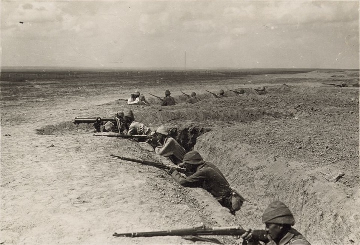
“The trenches at Hereirah” Gaza Line, 1917; Turkish army WW1 , American colony, Library of Congress
-
Excavations
Excavations were conducted by University of Ben Gurion in Beersheba, with assistance of other academic institutes. The teams was headed by E.D. Oren (1982-1988, 2010). Based on the findings and Biblical description, both E.D. Oren and Y. Aharoni suggested that Tell Abu-Hariereh is indeed Gerar.
Photos:
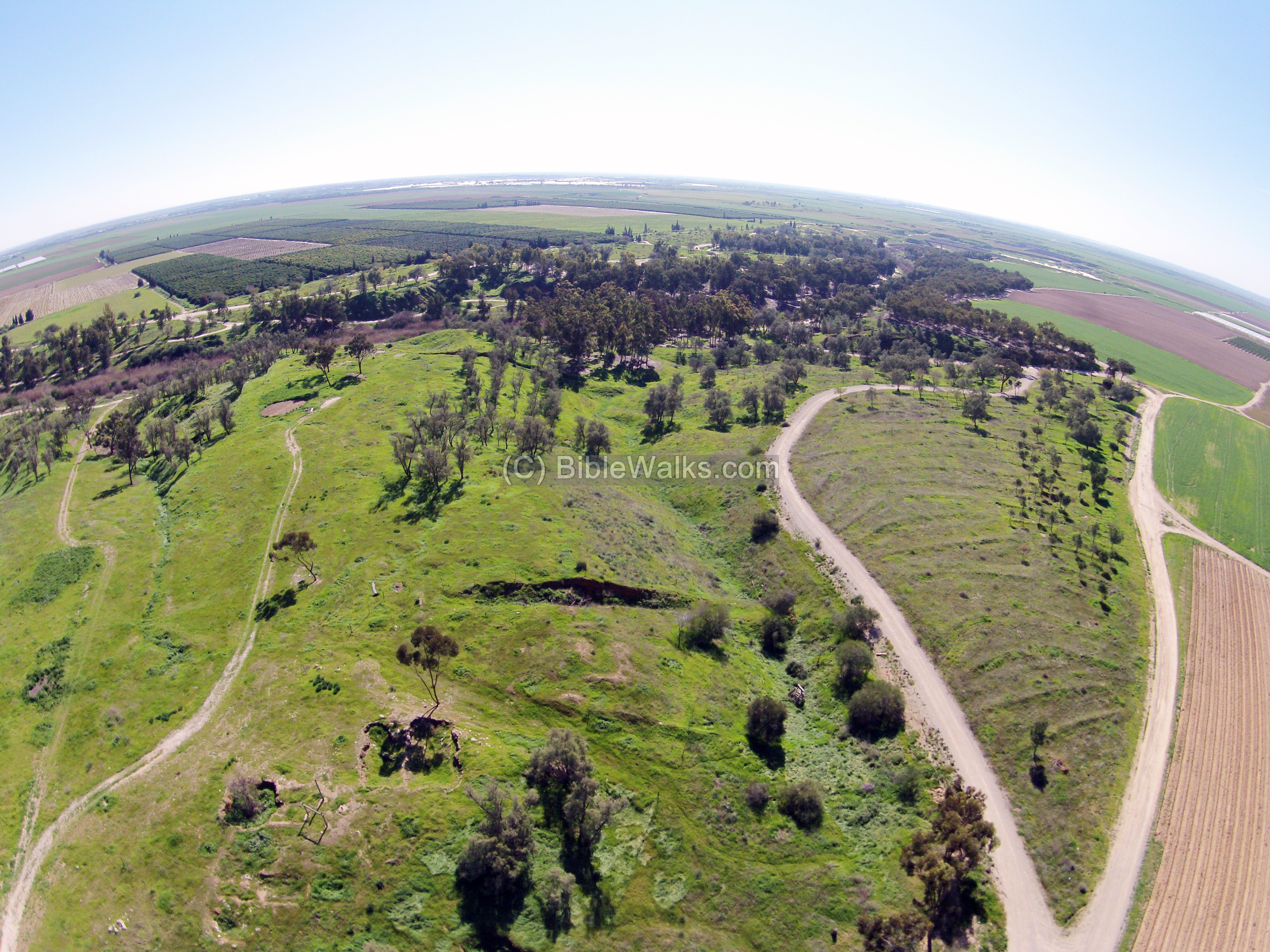
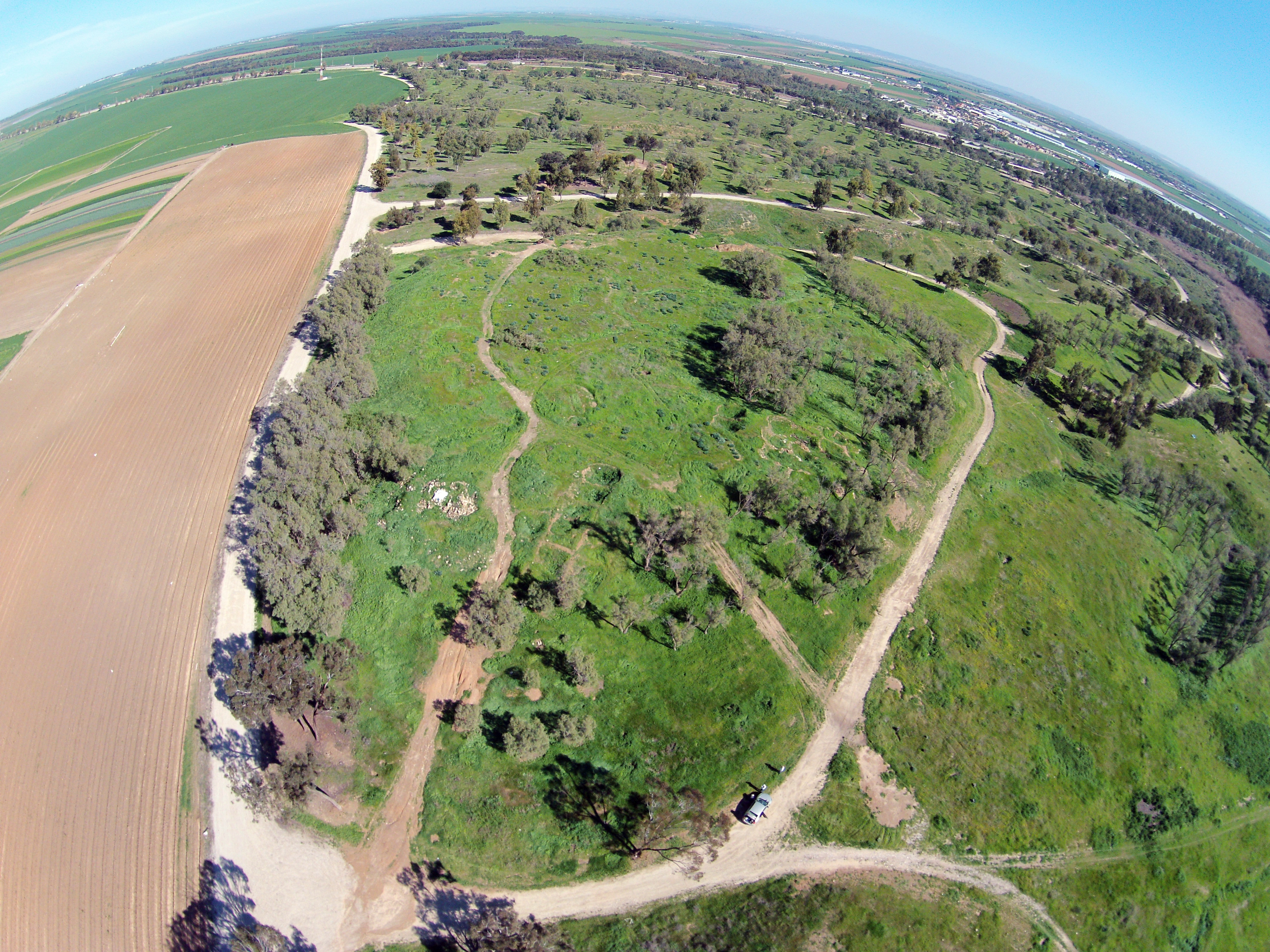
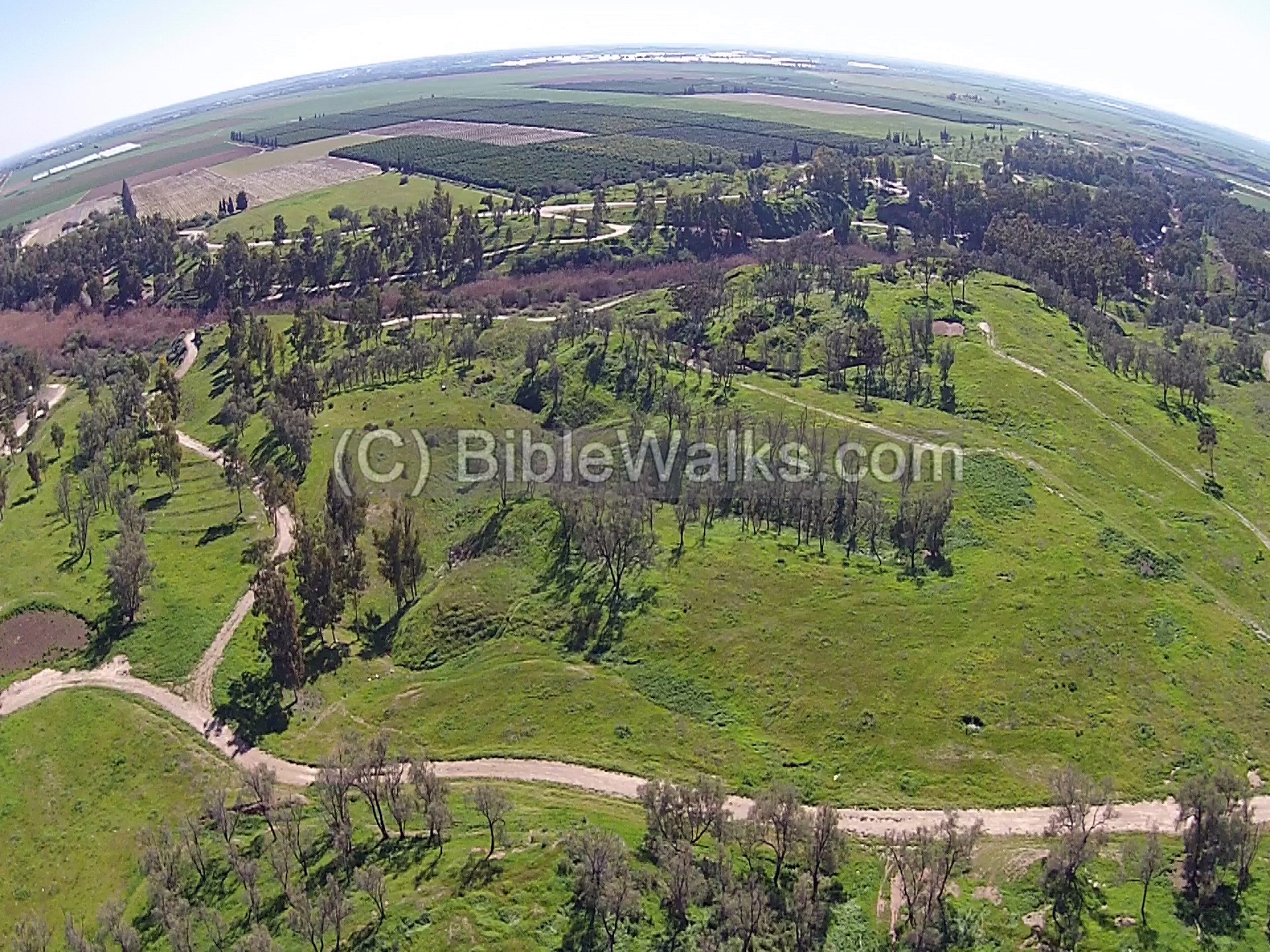
(a) North West
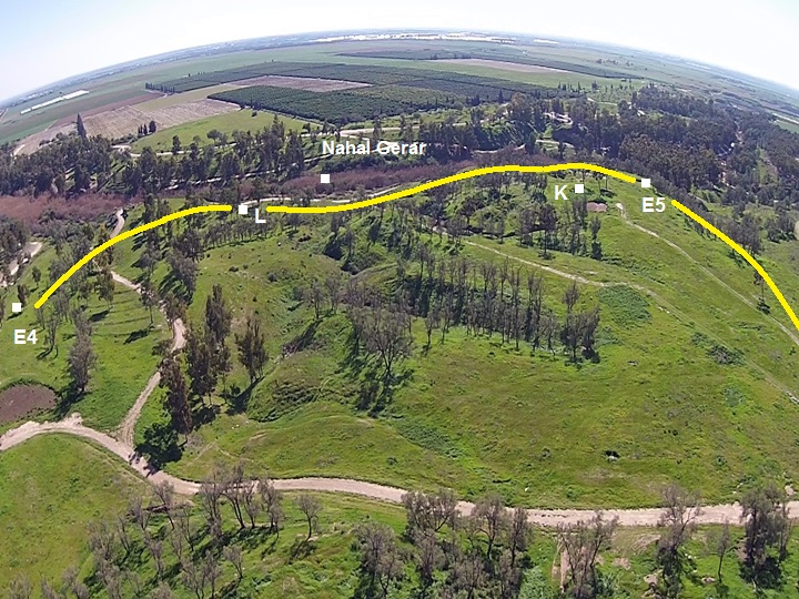
A drone captured this view of the north west side of Tel Haror, viewing to towards the south. This is the western side of the lower city. The enormous mound extends 300m from this point to Nahal Gerar at the edge of the green area of the mound.
Click on the photos to view in higher resolution…
To better describe this view, excavation areas were marked on the photo with white squares. A yellow line shows the western and southern walls of the lower city, and the location of Nahal Gerar.
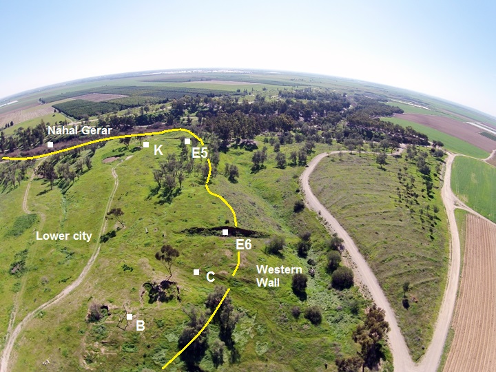
The following photo shows a ground level view of the lower city. The trench is Area B, located on the north west corner of the mound. The excavations dated the findings at this location as Middle Bronze II.
Behind, on the left background of the photo below, are the foothills of the Upper city.
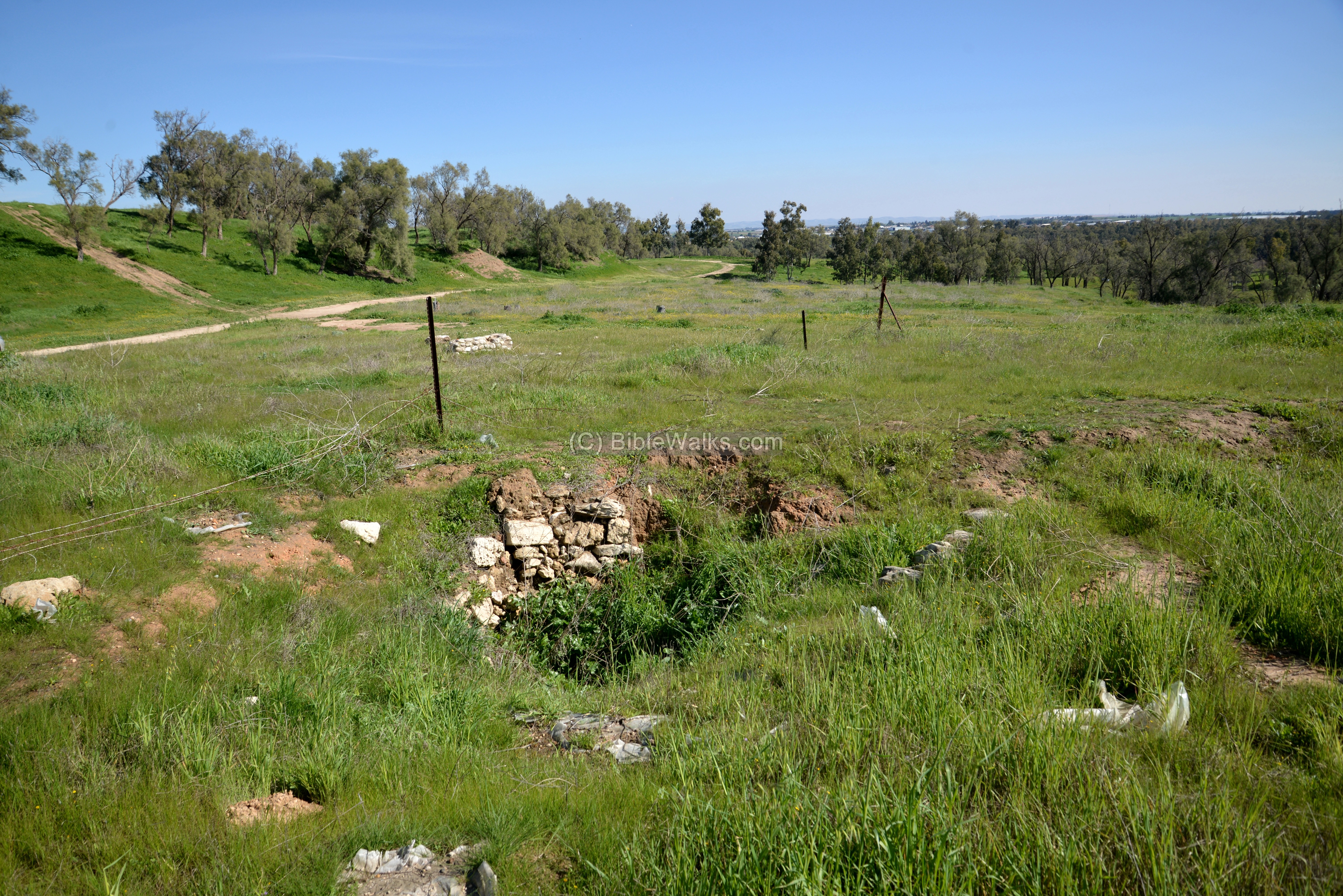
Another view of area B is in the next photo:
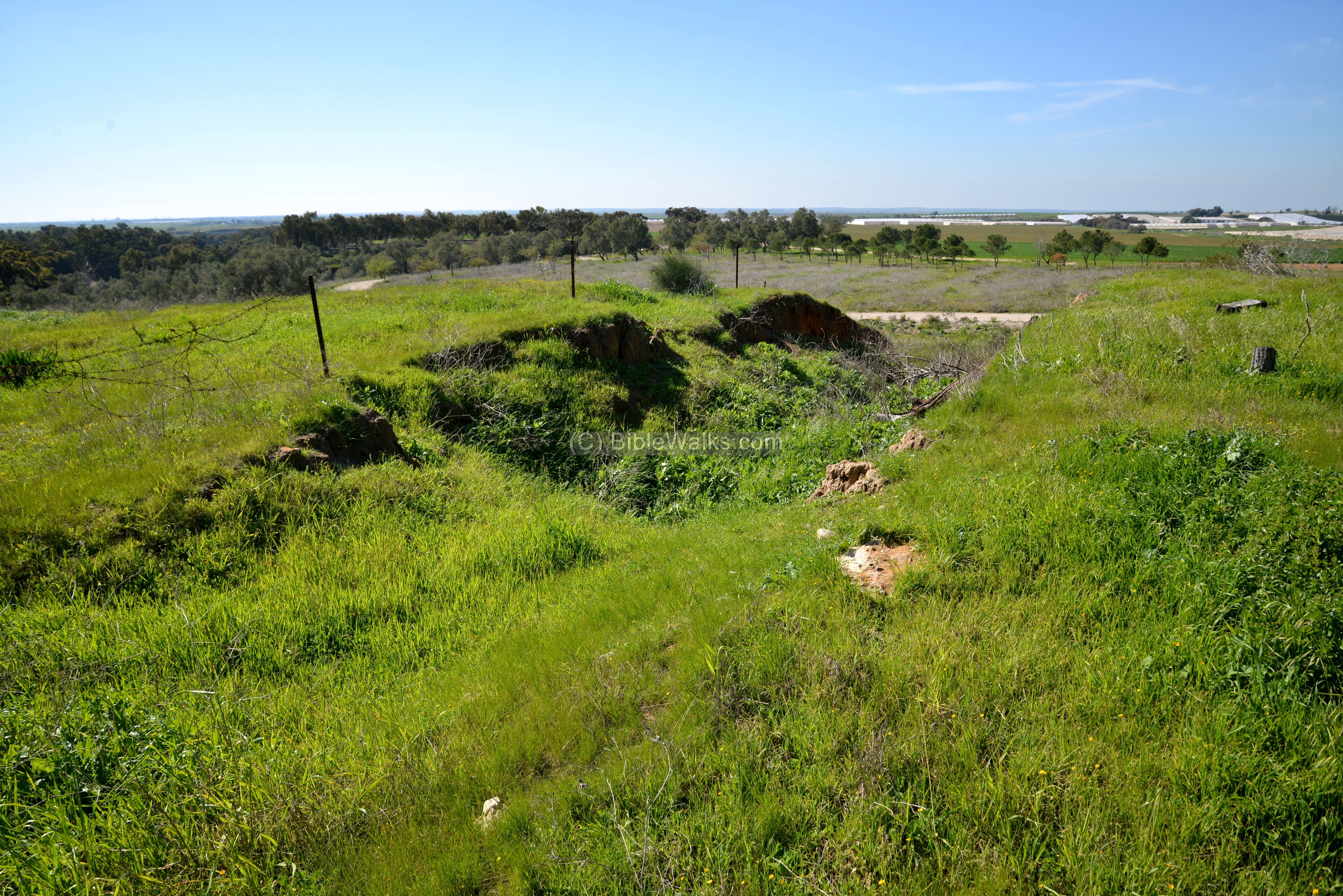
Next is area E6, which is also on the north west side. The excavation trench cuts into the western wall. Notice the height of the mound in relation to the fields around it. This was achieved by massive earthworks and walls during the MBII period.
(b) North East – Upper city
The next view is from the north west towards the Upper city.
To explain this view, upper city walls were added in yellow lines on this view. Excavation areas were marked with white squares. The Sheikh’s tomb location is marked on the north-west side of the Upper city.

Ruins of the Sheikh’s tomb (or, rather a shrine) are seen on the north edge of the upper mound. Not much left of it. In the 19th century, the PEF surveyors wrote about it: “There is a tomb of the Sheikh inside; the building covered with a cloth, and decorated with rags and votive offerings. Abu Hareireh was one of the companions of the Prophet”.
(c) South – Lower city
The next view is from the north towards the southern side of the lower city.
To explain this view, lower city walls were added in yellow lines on this view. Excavation areas were marked with white squares.
(d) Flight over the site
![]() The following YouTube video shows a flight of a drone over the north side of the mound.
The following YouTube video shows a flight of a drone over the north side of the mound.
Biblical:
Genesis 20
Abraham stayed in Gerar, his wife Sarah was taken then released by the king of Gerar.
Genesis 23
Isaac dwelt in Gerar, his wife was also taken and returned by Abimelech.
Etymology (behind the name):
* Names of the site:
- Tel Haror – Hebrew name of the mound
- Tell Abu Hariereh – Arabic name of the mound
- Abu Hariereh (Harairah) – the Sheikh’s tomb is named after this person. He was one of the companions of Muhammad and important transmitter of hadith. Born 600, died 678. His nickname was given by the prophet; the name means “father of the kitten”, as he was fond of cats. According to Oxford academic press, he converted from sun worship to Islam at age thirty.
- Gerar – the name of the city and the stream; unknown meaning.
- Nahal Gerar – Hebrew: stream of Gerar
- Wady esh Shariah – the Arabic name of the stream. Means: “The valley of the watering place”.
Links and References:
* Archaeology and History:
- Aharoni, Y. “The Land of Gerar.” Israel Exploration Journal, vol. 6, no. 1, 1956, pp. 26–32. JSTOR, www.jstor.org/stable/27924640
- Onomasticon -translation
- Who was Abu Hurairah – father of kittens
* Biblewalks sites:
- Drone Aerial views – collection of Biblical sites from the air
BibleWalks.com – searching the lost cities of the Bible
Burna<–previous Shefela site—<<< All Sites>>>
This page was last updated on Apr 8, 2023 (new overview)
Sponsored links: