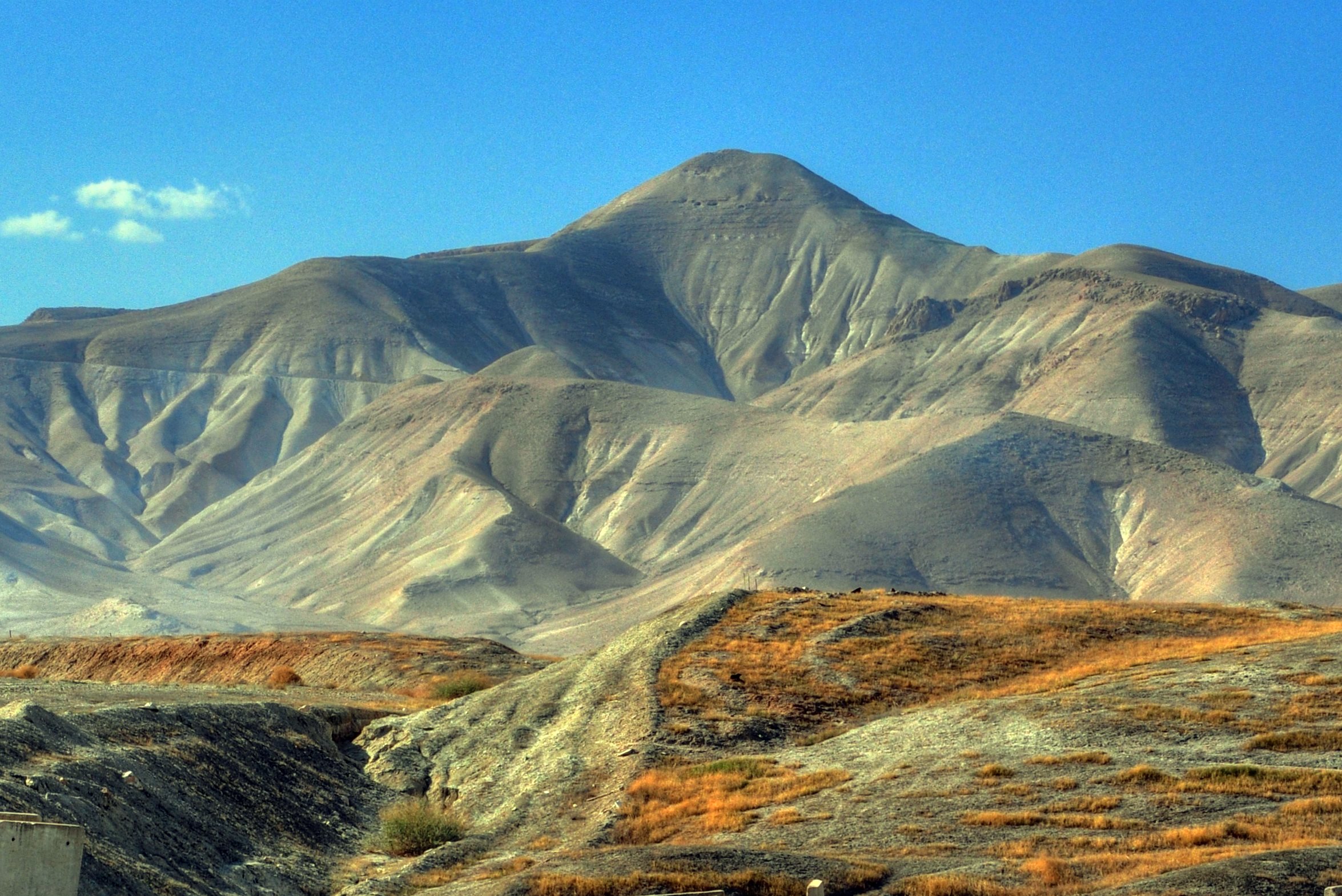
A Hasmonean and Herodian desert fortress on a high pointed mountain, overlooking the Jordan valley.
Home > Sites > Samaria > Sartaba (Alexandrion, Alexandrium)
Contents:
Overview
Aerial Map
History
Photos
* Aerial Views
* Ascent trail
* Eastern Cisterns
* Hosmonean fortress
* Herodian Palace
* Heart Shaped columns
* Commanding views
Video tour
Etymology
Links
Overview:
Sartaba – A pointed hill towering 600m above the Jordan valley. The Hasmonean King Alexander Jannaeus (104-77 BC) built a formidable desert fortress (“Alexandrium”, “Alexandrion”) on its summit. It was later refortified by Herod, who used this remote fortress as a prison for his wife and her mother, and burial place for his two sons after executing them. The fortress was demolished by the Romans during the great revolt.
On the summit are ruins of the fortress and a signal fire tower that was used to proclaim the new moon to the Jewish diaspora during the second temple period, starting from the Mount of Olives in Jerusalem. On the west side are ruins of a palace, with sections of heart- shaped columns on its corners. On the lower foothills are large water cisterns that were fed from an aqueduct from the west side.
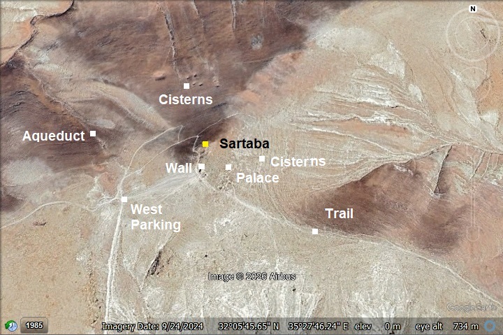
Map / Aerial View:
An aerial map is shown here, indicating the major points of interest around the site. The site is located on a high conical peak at 379m above sea level, 620m above the #90 highway in the Jordan valley. It is the highest peak in the south Samaria desert area.
History:
- Biblical connection?
Some scholars have suggested a potential link to the biblical city (or place) of Tzartan or Zaretan (צָרְתָן), mentioned near the location where the Israelites crossed the Jordan River, although this connection is considered uncertain by many researchers. The linguistic similarity between Tzartan (or Zarethan) and Sartaba has intrigued researchers for decades, primarily because the biblical description of the landscape aligns so closely with the geological uniqueities of the Sartaba region.
The most famous mention of Zarethan occurs during the crossing of the Jordan River. The text describes the water “piling up” at a specific location: “…the waters which came down from above stood and rose up upon an heap very far from the city Adam, that is beside Zaretan…”
Since the city of Adam is widely identified with Tell ed-Damiya (right at the foot of Sartaba), the proximity of Zarethan to Adam in the biblical text makes Sartaba a prime candidate for the location.
Interestingly, geological records show that landslides from the steep slopes of the Sartaba ridge have historically blocked the Jordan River (as recently as 1927), creating a natural “heap” of water—exactly as described in the Book of Joshua.
Sartaba has incredible Hasmonean and Herodian remains, there hasn’t yet been definitive evidence of a major Late Bronze Age or Iron Age settlement (the time of Joshua and the Monarchy) on the peak itself. Zarethan was also noted for its bronze casting foundries (1 Kings 7:46), which would typically be located in the valley near clay sources, not on a mountain peak.
Even if the Iron Age city of Zarethan was located in the valley below, the prominent mountain above it likely carried the name into the Second Temple period, eventually evolving into the “Sartaba” we know from the Mishnaic period.
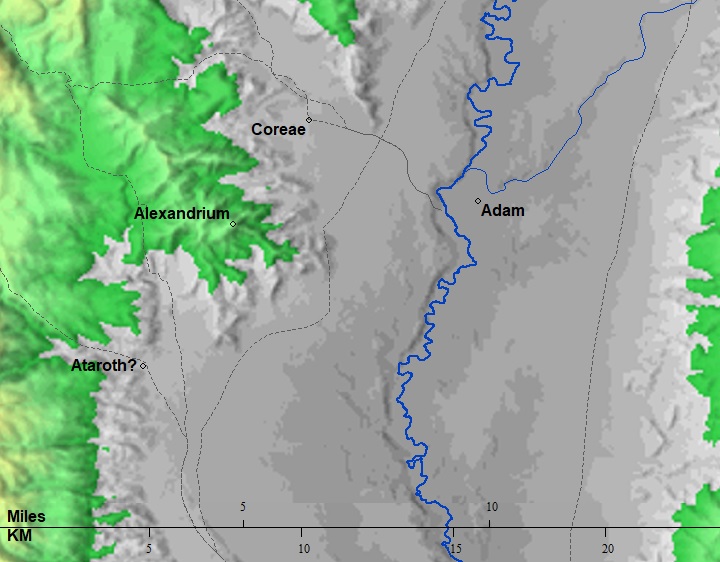
The cities and roads during the ancient periods, up to the Roman period, are indicated on the Biblical Map below. Sartaba is marked as “Alexandrium”, and the city of Adam is on the east bank of the Jordan river.
Map of the area – during the Israelite to Roman periods (based on Bible Mapper 3.0)
- Hasmonean period
The Hasmonean King Alexander Jannaeus (104-77 BC) built a formidable desert fortress on its summit. Jannaeus named the site Alexandrium after himself (or potentially his father, John Hyrcanus I, whose Hebrew name was also Alexander). It served as one of a string of Hasmonean “desert castles” that protected the eastern border of Judea and secured the vital route between Jerusalem and the Jordan Valley. Beyond the military advantage, there was a psychological element. By placing a fortress on the highest, most visible peak in the Jordan Valley, Jannaeus was “planting his flag.” It signaled to the Nabateans to the east and the Romans to the north that the Hasmonean Kingdom was a centralized, powerful state capable of massive engineering projects.
After the death of Jannaeus, his wife, Queen Salome Alexandra, took control of the kingdom. She used Sartaba as a secure repository for the royal treasures. According to Josephus, it was one of the three “impregnable” fortresses (along with Hyrcania and Machaerus) that she did not hand over to the Pharisaic leadership, keeping them under her direct control for the security of the crown.
The most visible remnants of the Jannaeus era are the massive ashlar stones found at the lower levels of the summit. These stones are easily identified by a smoothed frame (the margin) around a rough, protruding center (the boss). This “bossed” look was a deliberate choice that made the walls look even more rugged and intimidating to anyone looking up from the valley. Unlike the Herodian period, which used high-quality mortar and plaster, the Hasmonean walls relied on the sheer weight and precision-cut of these massive stones.
An AI generated illustration shows a figurative view of the fortress from the north west side. The walled fortress was built over the higher north side of the summit.
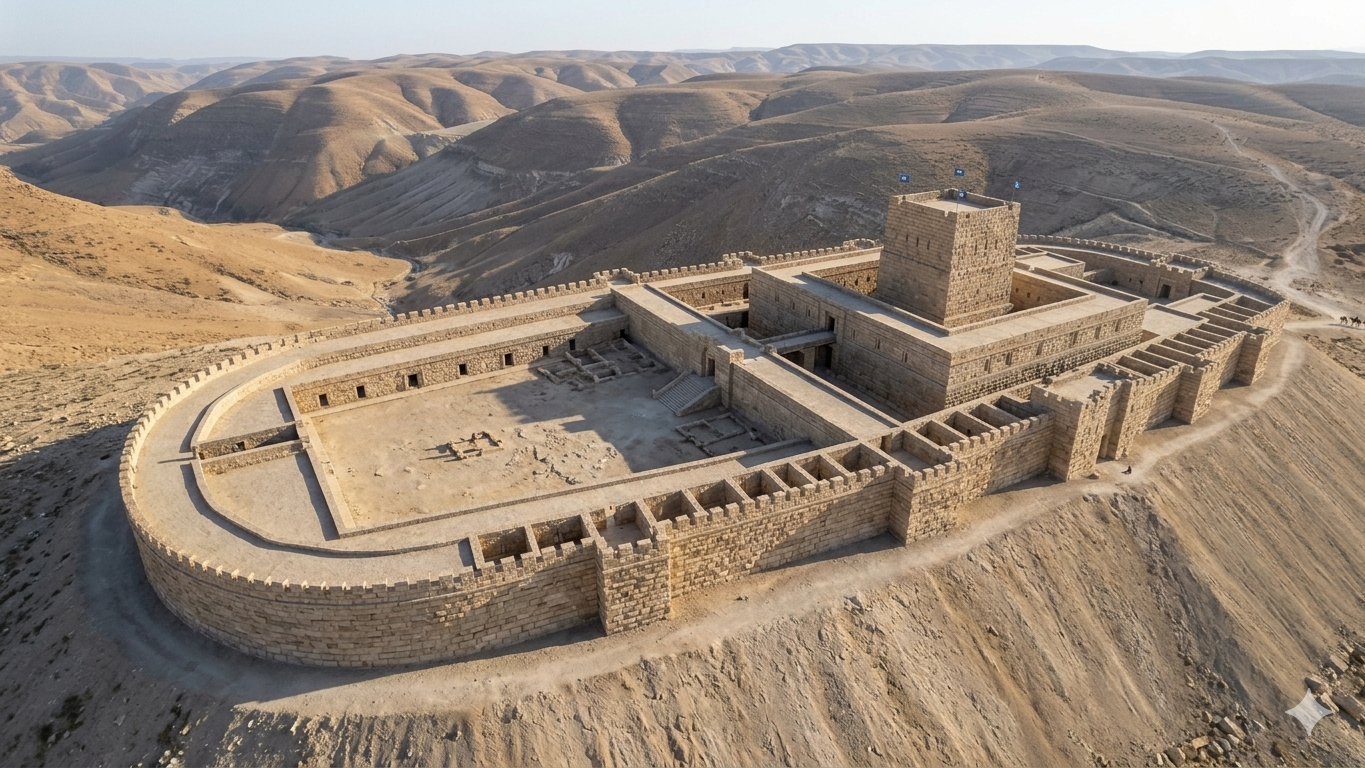
Proposed reconstruction of Sartaba fortress – AI generated Credit: Gemini AI / BibleWalks Collection
Jannaeus knew that the greatest threat to a desert fortress was thirst, not the sword. He ordered the excavation of the massive cisterns at the base of the cone. These were cut directly into the hard limestone. Josephus records that the Hasmoneans used these remote fortresses—Sartaba, Hyrcania, and Machaerus—as royal treasuries. The isolation of the peak made it the safest place in the kingdom to hide the royal gold and state documents.
The Hasmonean fortress was built with a casemate wall—two parallel walls with a space in between that was either used for storage or filled with rubble during a siege. To prevent attackers from climbing the steep conical hill or using battering rams, the slopes were likely smoothed or covered with a slick stone “glacis,” making it nearly impossible to gain a foothold under fire from the ramparts above.
- Roman/Byzantine period
During the Roman period, Sartaba—known in Greek and Latin as Alexandrium—was one of the most formidable and strategically significant desert fortresses in Judea. Perched atop a distinctive conical peak 379 meters above sea level, it commanded a 360-degree view of the Jordan Valley and the road to Jerusalem.
- The Roman Conquest (63–57 BC)
The Roman era began with conflict. In 63 BC, during Pompey the Great’s campaign, the Hasmonean prince Aristobulus II surrendered the fortress to the Romans. This is the story behind it:
Judea was in the midst of a bloody civil war between two Hasmonean brothers: Hyrcanus II (the elder, supported by the Pharisees) and Aristobulus II (the younger, more aggressive brother supported by the Sadducees). When the Roman general Pompey arrived in Damascus, both brothers appealed to him for support. Pompey, realizing that the weaker Hyrcanus would be easier to control, began to favor him. Sensing he was losing Roman favor, Aristobulus left the negotiations in a fit of rage and fled south to entrench himself in his most formidable desert stronghold: Sartaba.
Pompey viewed this retreat as an act of rebellion and marched his legions into the Jordan Valley. Pompey arrived at the foot of the conical mountain and sent a message to the summit, ordering Aristobulus to descend and surrender all his fortresses. Aristobulus was in a dilemma. His pride urged him to fight from his “impregnable” heights, but his advisors warned him that Rome could not be defeated. He descended multiple times (!) to negotiate with Pompey, trying to stall for time while simultaneously sending secret orders to his generals to prepare for war in Jerusalem.
Pompey eventually lost patience. He forced Aristobulus to sign a written order commanding his commanders to surrender all Hasmonean fortresses. Realizing that the Romans were prepared to besiege the peak and cut off his water supply (the famous aqueducts), Aristobulus finally yielded the fortress.
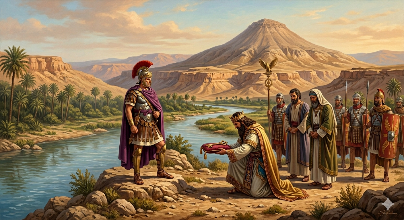
Proposed reconstructed scene of Sartaba surrender – AI generated Credit: Gemini AI / BibleWalks Collection
The fact that Pompey didn’t simply attack the summit but chose to force a diplomatic surrender highlights how intimidating the Sartaba fortifications were to the Romans. In Antiquities of the Jews, Book 14, Chapter 3, Section 4 (or 14.48 in some numbering systems), Josephus Flavius provides a striking description of Pompey’s first encounter with the fortress. As Pompey marched his legions into Judea from the north, he reached a place called Coreae (modern Karawa), where he looked up and saw the Hasmonean stronghold dominating the horizon. Josephus writes:
“…as he passed by Pella and Scythopolis, he came to Coreae, which is the first entrance into Judea when one passes over the midland countries, where he came to a most beautiful fortress that was built on the top of a mountain called Alexandrium, whither Aristobulus had fled.”
In the parallel account in The Jewish War (Book 1, Chapter 6), Josephus adds that the fortress was “extraordinarily high” and “situated upon a very high mountain.”
While Aristobulus surrendered the physical fortress of Sartaba, his heart remained rebellious. He fled to Jerusalem to prepare a final stand, leading to the bloody Roman Siege of Jerusalem in 63 BC, where Pompey eventually breached the Temple Mount. This was the specific moment when the Hasmonean dynasty lost its true sovereignty. From this point on, Judea was a Roman client state.
- Gabinius destroys Sartaba
Following the surrender of Aristobulus II, the fortress remained a symbol of Hasmonean resistance. A few years later, Aristobulus’s son, Alexander, attempted to re-fortify the site as a base for a new rebellion against Rome. In Antiquities 14, Chapter 5, Section 4, Josephus describes the Roman response led by Aulus Gabinius, Pompey’s successor in the region:
“…Gabinius came to Alexandrium, and as he caused [the rebels] to surrender, he demolished the fortress, that it might not at any time be a signal for war; as also he did to Hyrcania and Machaerus.”
Archaeological surveys have identified several Roman siege camps located at the foot of the hill, strategically placed to block the access paths and the water channels. Josephus records that the Roman forces “pressed the siege,” but the victory was won through a combination of a fierce battle at the foot of the hill and the eventual realization by the defenders that they were isolated.
Gabinius then demolished the fortress in 57 BC to prevent it from being used as a base for Jewish nationalist rebels.
- Herod the Great’s Architectural Splendor
The site was later rebuilt by Herod the Great, who transformed the rugged Hasmonean outpost into a magnificent palatial retreat. The Herodian Palace didn’t just replace the Hasmonean fort; it repurposed it. Herod “shaved down” the Hasmonean foundations to create his perfectly flat peristyle platform.
Recent excavations have revealed a monumental peristyle (colonnaded) hall. The structure was located on the uppermost “terrace”, 40m below the peak. It was a rectangular or square open-air courtyard surrounded on all four sides by covered colonnades. The palace featured Doric columns, intricate mosaics, and walls decorated with fresco and stucco in the latest Roman styles.
An AI generated illustration shows a figurative view of the palace from the south east side.
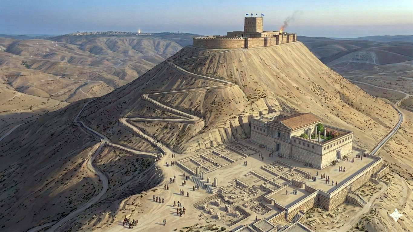
Proposed reconstruction of Sartaba Herodian palace – AI generated Credit: Gemini AI / BibleWalks Collection
Herod used the isolated fortress for dark political purposes. He imprisoned his wife, Mariamne, and her mother, Alexandra, here in 30 BC. Most tragically, it served as the final resting place for his two sons, Alexander and Aristobulus, whom he executed at Sebaste in 7 BC.
To sustain life in the barren desert, Herod’s engineers expanded and refined the massive aqueduct system nearly 4 kilometers long, channeling winter flash floodwaters into deep rock-cut cisterns. Herod required much more water than a simple garrison. He built Roman-style baths (thermae) on the summit, which required a constant and massive supply of water. The presence of cold, lukewarm, and hot rooms (frigidarium, tepidarium, and caldarium) on a desert peak was a profound display of power over nature.
- The Beacon of the New Moon
In Jewish tradition, Sartaba played a vital role in the Second Temple religious calendar. As recorded in the Mishnah (Rosh Hashanah 2:4), Sartaba was the second station in a chain of beacon fires that signaled the arrival of the New Moon from Jerusalem to the Jewish communities in Babylon. “From the Mount of Olives to Sartaba, and from Sartaba to Grofina…”
When the first sliver of the new moon was spotted and confirmed by witnesses, the signal fire was lit on the Mount of Olives. The watcher on Sartaba would see it, light their own fire, which in turn was seen and repeated by the watcher at Grofina (perhaps a hill top in Gilead). This allowed the announcement to travel rapidly to the northern regions and eventually to the Jewish community in Babylonia.
Reconstruction of Sartaba fire signals – AI generated Credit: Gemini AI / BibleWalks Collection
The fire signaling system (the Mesu’ot) was abandoned around the mid-fourth century AD after the establishment of a fixed calendar. Under the leadership of Hillel II, the Jewish community transitioned to a fixed, calculated lunisolar calendar. Once the calendar was predictable and mathematically determined, the need for a physical, visual confirmation of the New Moon—and the dangerous, labor-intensive relay system—became obsolete.
- The Great Revolt and Destruction (66–70 AD)
During the Great Jewish Revolt, the fortress was likely occupied by rebels once more. However, as the Roman Legions under Vespasian and Titus consolidated control over the Jordan Valley, the site was systematically razed. Unlike other desert fortresses like Masada, Sartaba was never resettled after its destruction in 70 AD, leaving its “heart-shaped” column drums and Herodian masonry to be swallowed by the desert sands.
After the 1st century AD the site was abandoned. It was further damaged by a massive earthquake, such as the 363 earthquake.
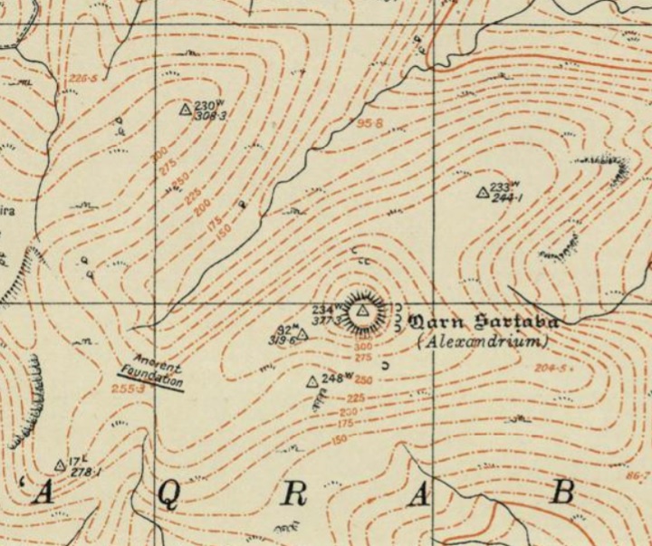
- Ottoman Period – (1516-1918 A.D.)
Conder and Kitchener of the Palestine Exploration Fund (PEF) surveyed the area during the Survey of Western Palestine (SWP) in 1874-75. This is a section of their map, focusing on the site.
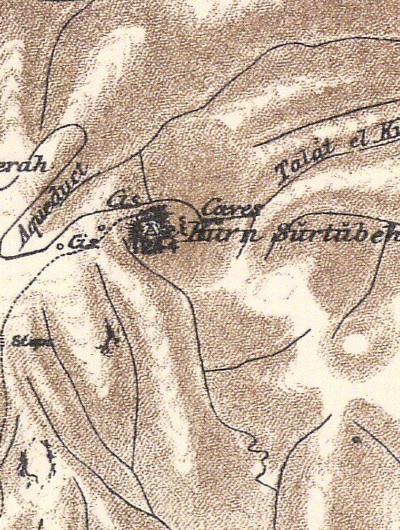
Part of map sheet 15 of Survey of Western Palestine,
by Conder and Kitchener, 1872-1877. (Published 1880, reprinted by LifeintheHolyLand.com)
The PEF survey was documented in Volume 2 (pp. 396-400). They wrote:
“Kūrn Sūrtūbeh —The ruins on the summit of this mountain consist of a central structure with a surrounding wall, and of an
aqueduct with cisterns. An old road leads up from the south, with rock cut steps in one place. The top of the mountain is a cone, artificially shaped, like that at Jebel Fureidis, and some 270 feet high. On all sides but the west this is practically unapproachable : on the west a trench has been cut, and the saddle thus made lower. The slope of the sides is about 35 degrees. The top measures 90 feet east and west, and 258 feet north and south, being an oval.”.The foundation measures 92 feet 9 inches along a line 189º, and 40 feet 6 inches at right angles. There is a set-back on the south-west of 14 feet for 26 feet 9 inches. A wall runs south from this foundation for 18 feet, being 20 feet 6 inches across. The outer rampart, now merely a mound, is 30 feet across, and covered with fallen masonry, as is also the eastern slope of the hill.
The foundation consists of 10 courses of masonry, the stones placed in alternate courses of header and stretcher, and varying from 11/2 feet to 4 feet in length, the height of the course being i foot 10 inches. They have drafts from 31/2 to 6 inches broad, and the boss is left rustic, with a projection in some cases of 5 inches. Forty-four feet from the north end of the central foundation are two excavations or pits sunk in the soft rock, where are traces as if of the effects of fire kindled at some time in them. The building seems to have been struck by lightning, or perhaps shaken by earthquake, and the side of the Tell on the east, for some 200 feet down, is strewn thickly with fallen ashlar, rather smaller than that of the foundation. The general appearance of the place is that of a fortress, with an oval outer enceinte and a central tower or keep, the foundations alone remaining…”.
The surveyors published this sketch of the surface water collection system, used to feed two of the cisterns (that are 40ft below the aqueduct level) and also to water gardens.
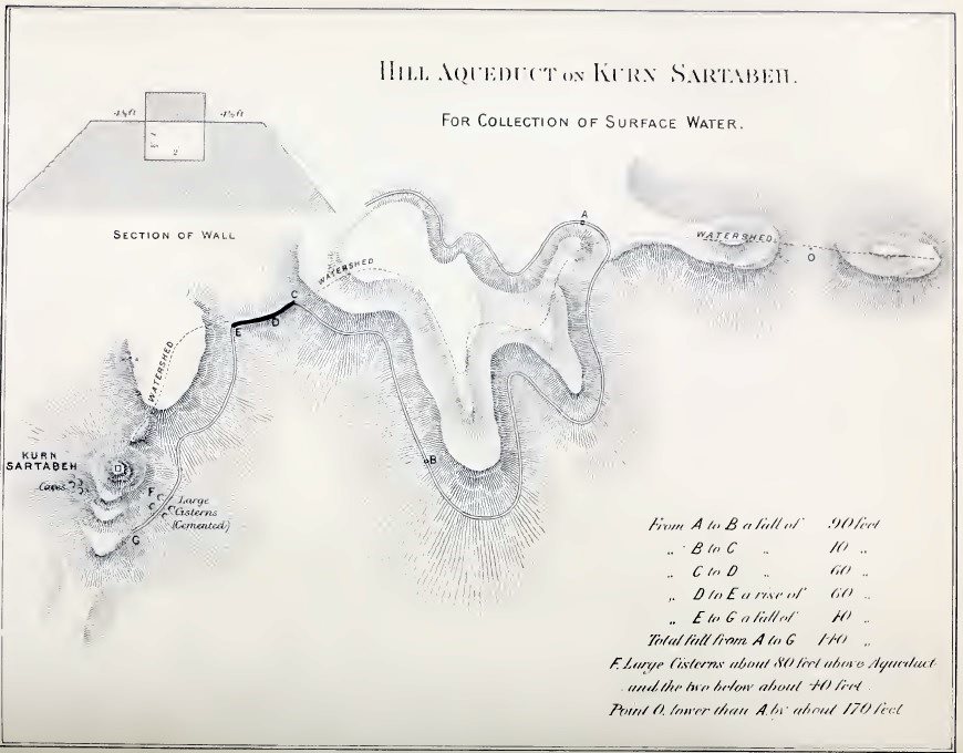
Map of Sartaba surface water collection system [P/O PEF survey, p. 396+]
They described:
“On the ridge west of the Tell there is a well. About 1/2 mile further west there is a low saddle, which has been artificially banked across ; and a long narrow wall runs on the bank, with remains of a channel 1 foot 3 inches deep and 2 feet wide, with covering blocks of stones, which were probably 8 or 10 feet long. This aqueduct was traced all round the north side of the Kurn block of hill, and evidently collected surface drainage, as the level prevents the supposition of its connection with any neighbouring spring or well of water.
The total length is about 2.5 miles, but the starting-point is only 3/4 mile west of the Tell. The watershed north of Ras Kaneitrah is 1 70 feet lower than the aqueduct on that side, and the line is plainly seen running round the hill, with a fall of 100 feet in about 1.5 miles, measuring to the bank across the saddle, where the channel dips in crossing, the centre being some 50 or 60 feet lower than the ends.
From the saddle the line runs directly east on the north side of the hill, with a fall of 40 feet in the mile. It supplies large cemented cave cisterns some 350 feet or more below the top of the Tell, and it runs past them to some terraces which seem artificial, and may have supported gardens irrigated by the channel.
In places the channel is built of large rudely hewn blocks. The well or cistern mentioned above, on the plateau west of the Tell, may perhaps have been connected with the aqueduct, being at rather a higher level. East of the Tell is a cave, or quarry, and south of it three more, rudely squared, and some 1 5 feet side ; the southern one is the roughest, and is now used as a goat-fold.
The central ruin on the Tell is called a ‘castle’ by the Arabs.
Visited 2nd and 5th of March, and 3rd April, 1874”.
- Other early visitors
Félix-Marie Abel (1878–1953) was a prominent French Dominican priest, geographer, and archaeologist at the École Biblique et Archéologique Française de Jérusalem. He visited and surveyed Sartaba in 1910. Abel described the summit as an artificial platform with an area of 100m by 40m. The south side of the summit is higher than the north side, and that is where the fortress was built. He published a rough plan of the fortress.
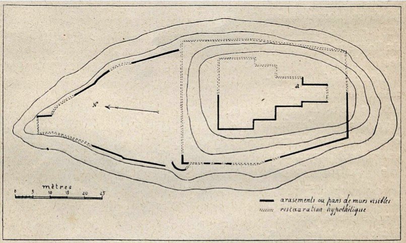
P/O Abel – Melanges: Exploration de la Vallée du Jourdain; 1910; p. 230
- British Mandate
A 1940s British map shows the area around the site. It shows cisterns on the north, east and south sides.
British survey map 1942-1948 – https://palopenmaps.org topo maps
License: public domain under the UK Copyright, Designs and Patent Act 1998
- Modern period excavations
Archaeological excavations, headed by Y. Tsafrir and Y. Magen, were conducted on Sartaba in 1981-1984, focusing on the terrace of the Herodian palace. They did not provide a detailed excavation report.
Adam Zertal thoroughly surveyed the site (in years 1993 thru 2003), and added valuable information in volume 4 of the The Manasseh hill country survey. According to a ceramic survey conducted on the summit and the eastern and northern slopes, the team dated the pottery to Hellenistic 30%, Early Roman 45%, Late Roman 10%, Byzantine 10% and Middle ages 5%.
- New excavations 2025
New excavations started in 2025, headed by Dr. Dvir Raviv. The team conducted excavations and surveys at several locations on the site – Areas A and A2 on the eastern slope, Areas B and C on the summit, as well as several additional areas. The team identified a total of 5 settlement levels -two phases during the Hasmonean period (two structures and a ritual bath), 2 phases during the Herodian period (peristyle building, cistern and pool), and one during the Great Revolt when the site was occupied by refugees or by a Roman garrison (walls, oven and layer of ash and rubble). The team also explored the water system and agricultural terraces on the northeastern slopes.
Photos:
The photos and videos were captured on Dec 2017.
(a) Aerial Views
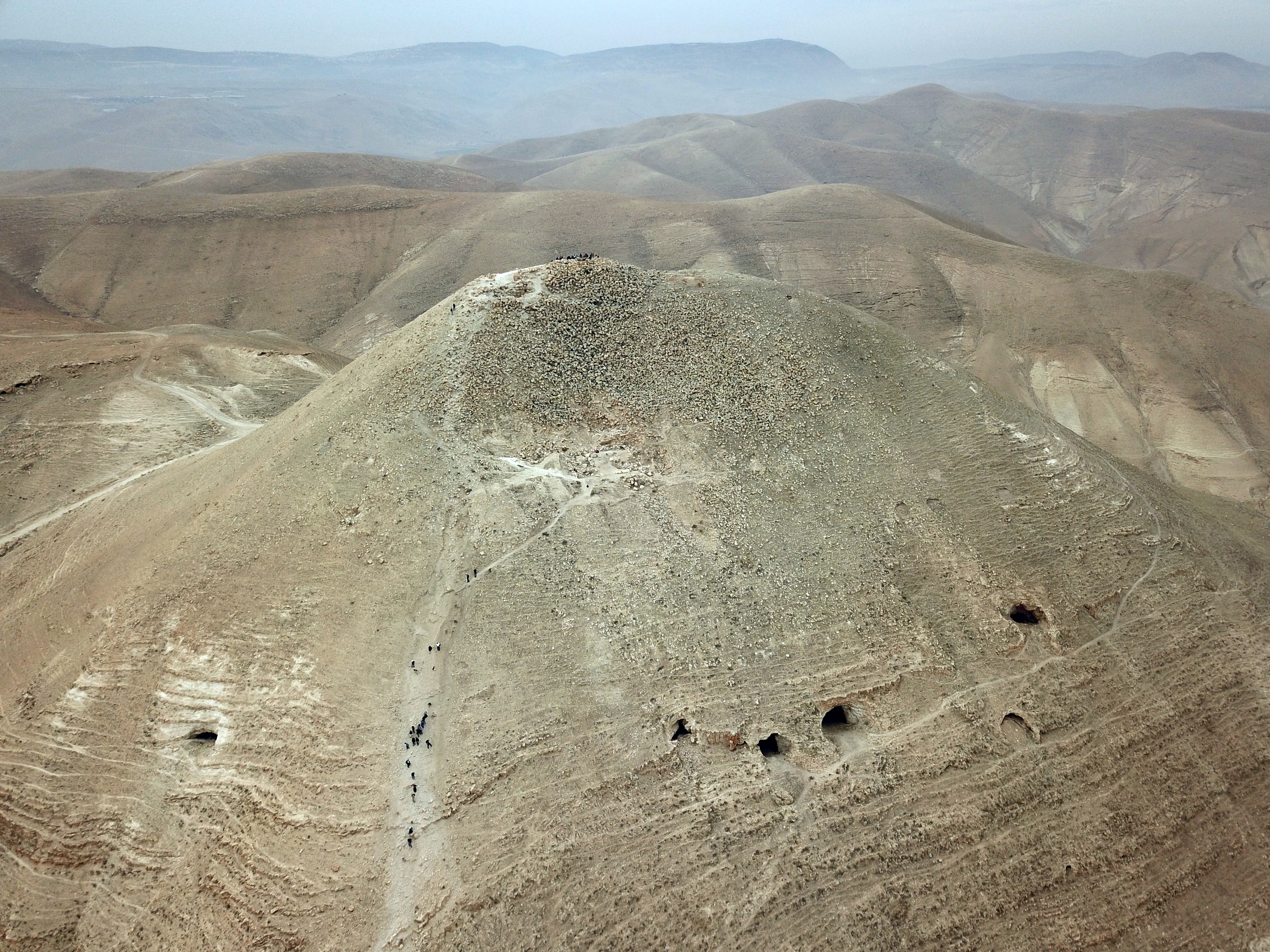
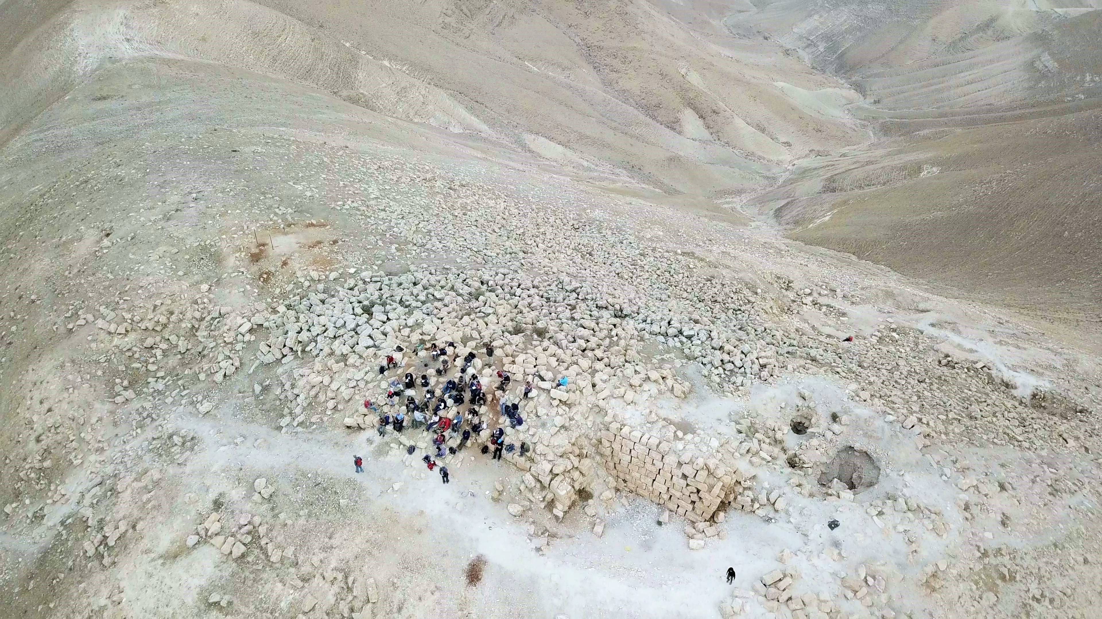
An aerial view of the mountain was captured by a drone from the south east.
A legend of the major points of interest is shown below. The Hasmonean fortress occupies the summit, but is mostly destroyed except for a few standing walls. Most of the structures were dismantled during the Roman period, and by severe earthquakes, and the rubble covers the eastern foothills. On a lower terrace are remains of a Herodian palace. Below it, on a lower height are a number of cisterns that supplied water for the occupants of the desert fortress, and were fed from an aqueduct that conveyed water from the western hill.
Flight over the site:
![]() The following YouTube video shows a flight of a drone over the site, captured on Dec 2017. The drone video starts from the summit, passes above the palace, then views the water cisterns along the eastern foothills.
The following YouTube video shows a flight of a drone over the site, captured on Dec 2017. The drone video starts from the summit, passes above the palace, then views the water cisterns along the eastern foothills.
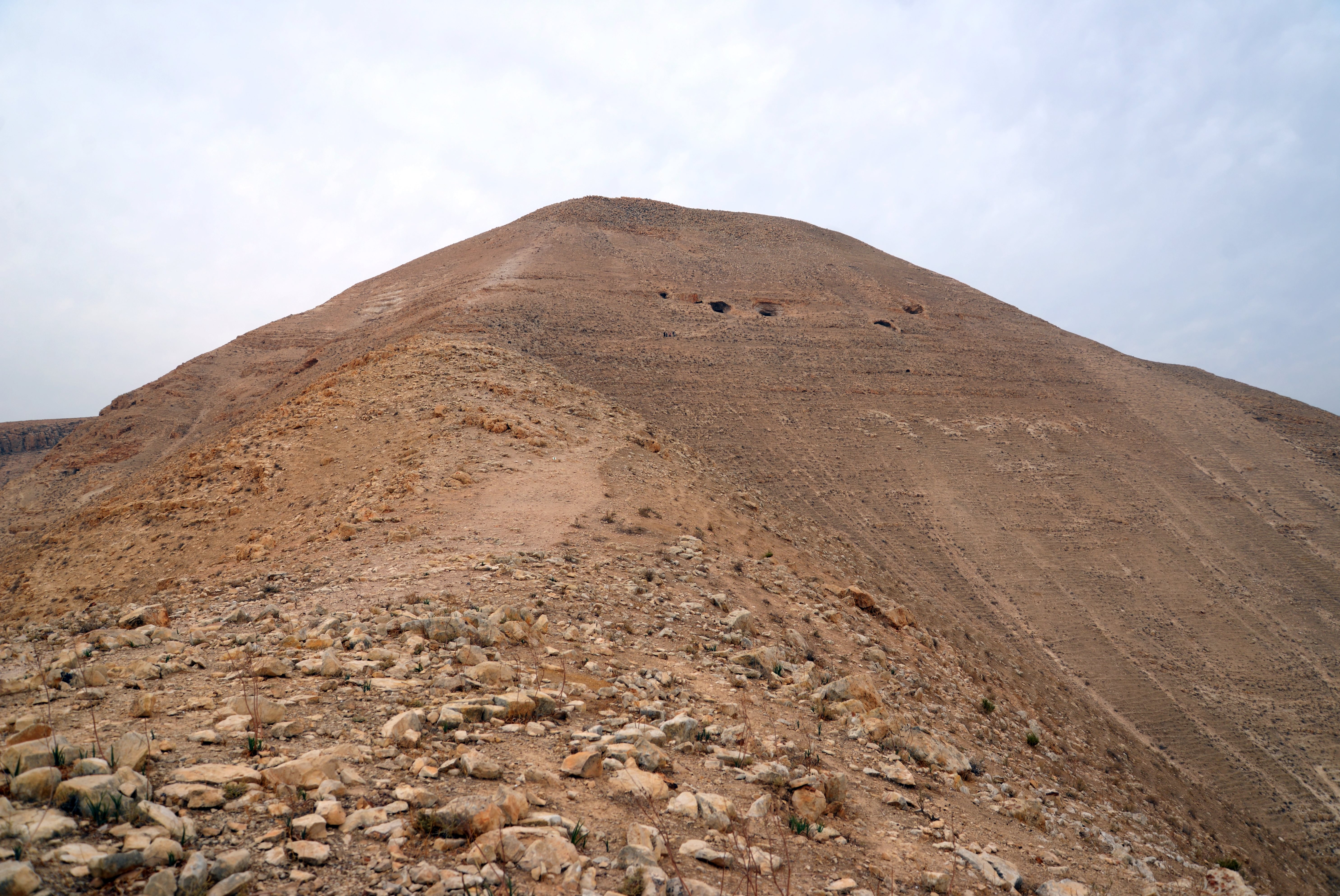
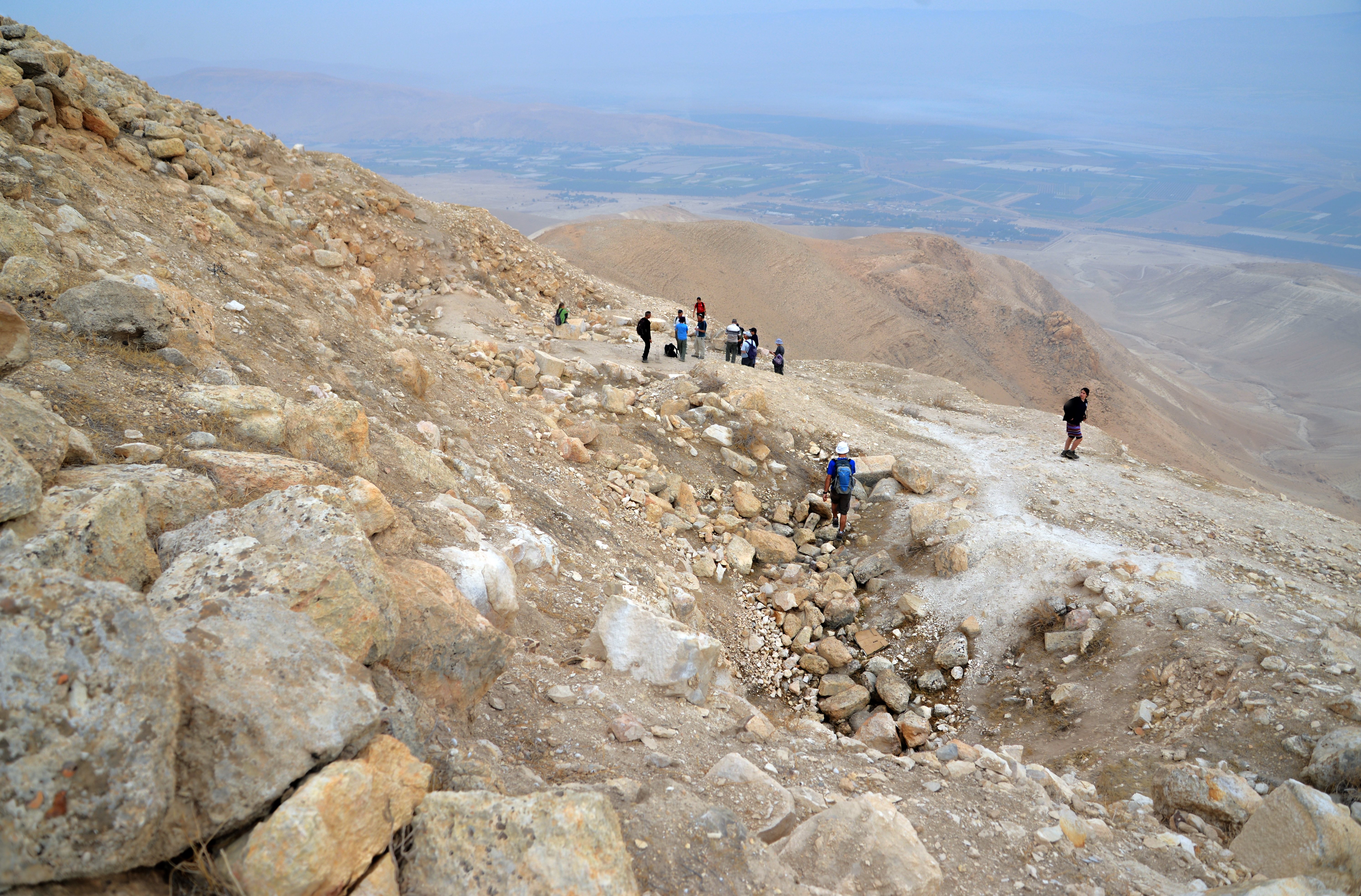
(b) Ascent to Sartaba
To really capture the scale of Sartaba, here is a view from the Adam (Damiya) Bridge crossing in the Jordan valley below. From there, you get a perspective of the site that shows just how high up this fortress really is. It looks like a “conical crown” dominating the entire region!
We ascended on foot to the mountain, after parking the car near the end of a road that ascends from highway #90 to a military base at the foot of the mountain.
There is an alternative easier way to reach the foothills – via a dirt road that winds around the hills and reaches to a parking area on the west side of the hill. Until recently that road was not suitable for private cars, but there are plans to improve it.
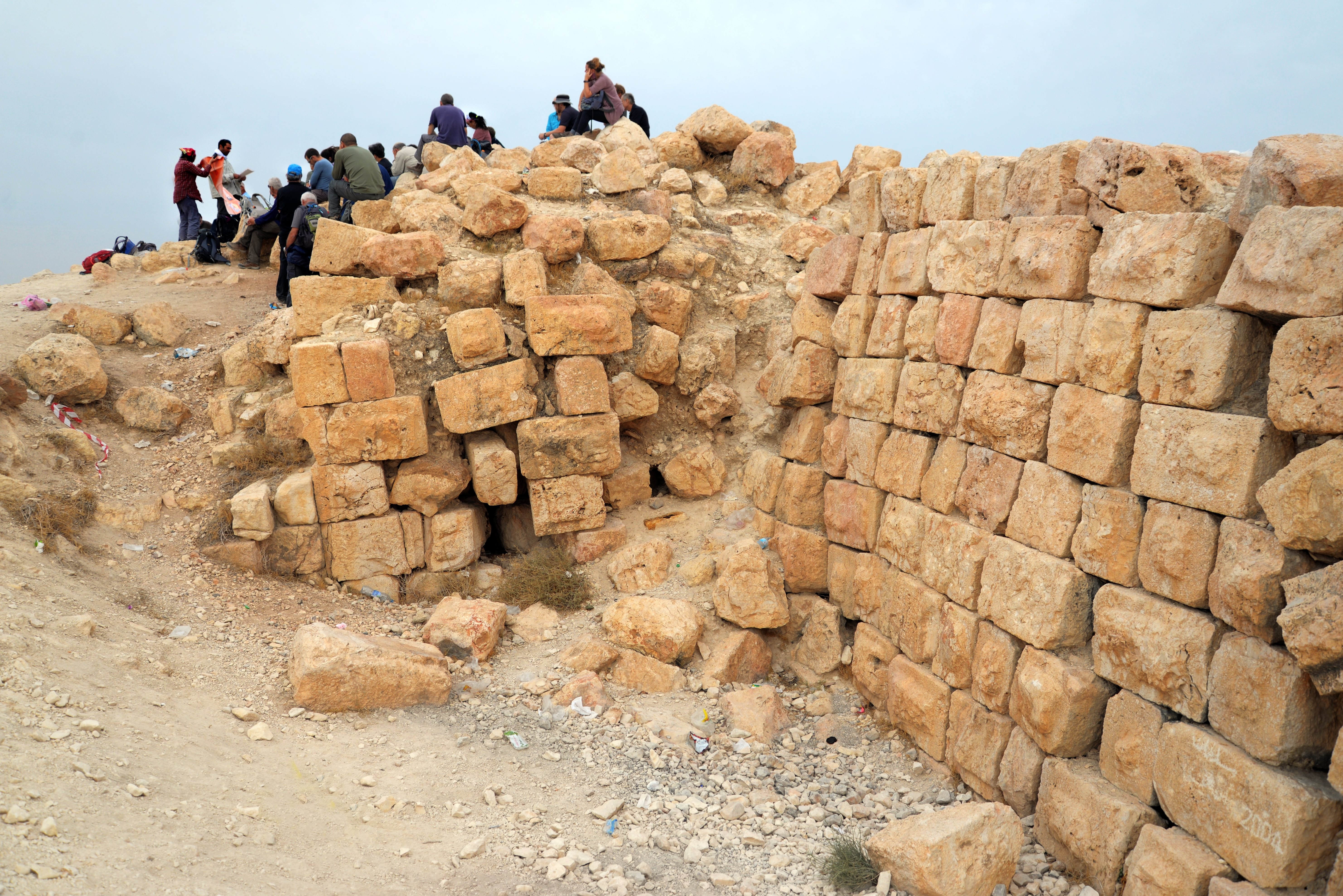
Click on the photos to view in higher resolution…
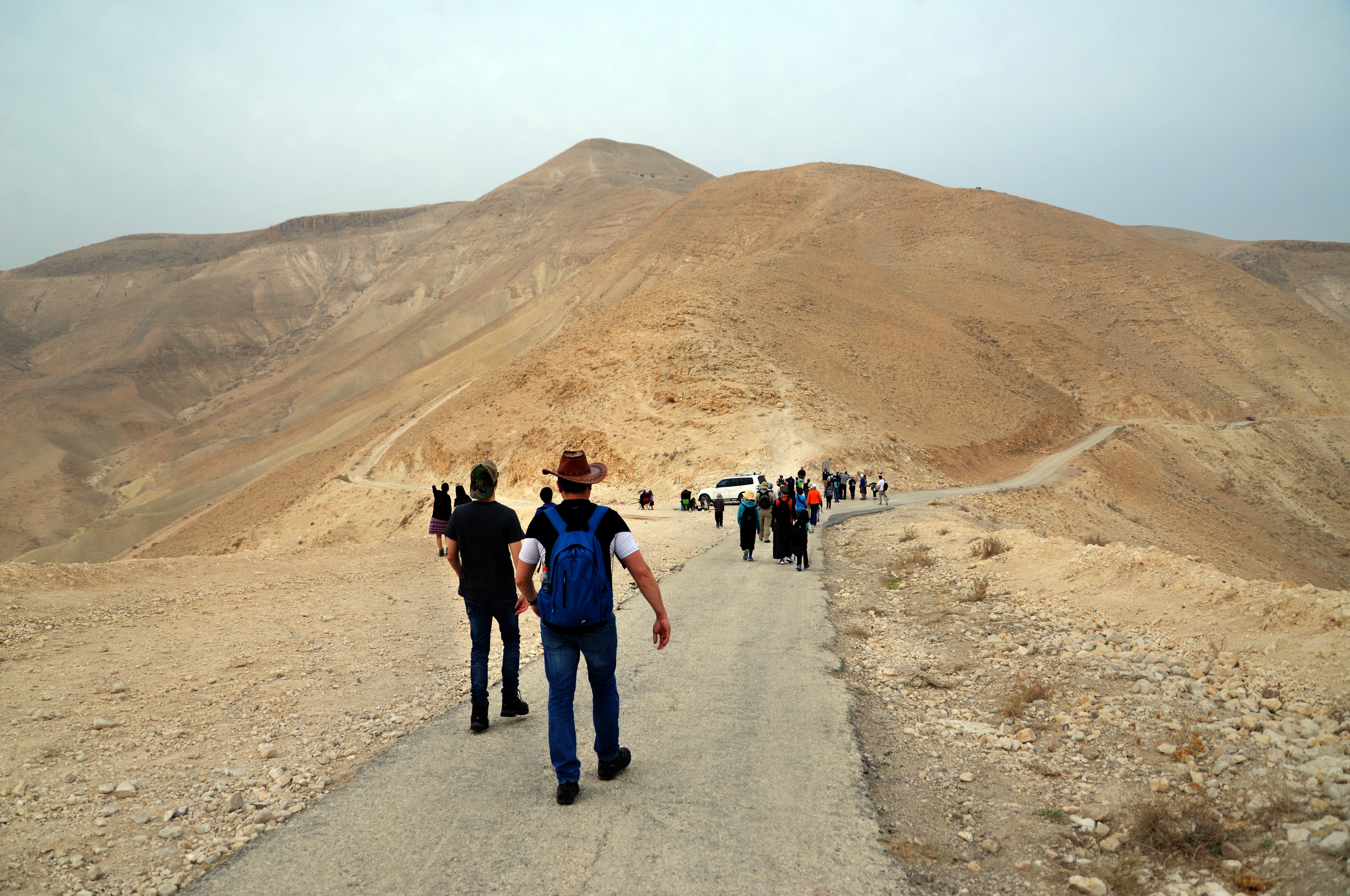
The steep trail, 1.3km long, climbs along the eastern face of Sartaba. Reaching closer to the summit, the trail splits to two: one trail continues upwards to the Herodian palace, while the northward trail, which we followed, continues north and passes the eastern cisterns.
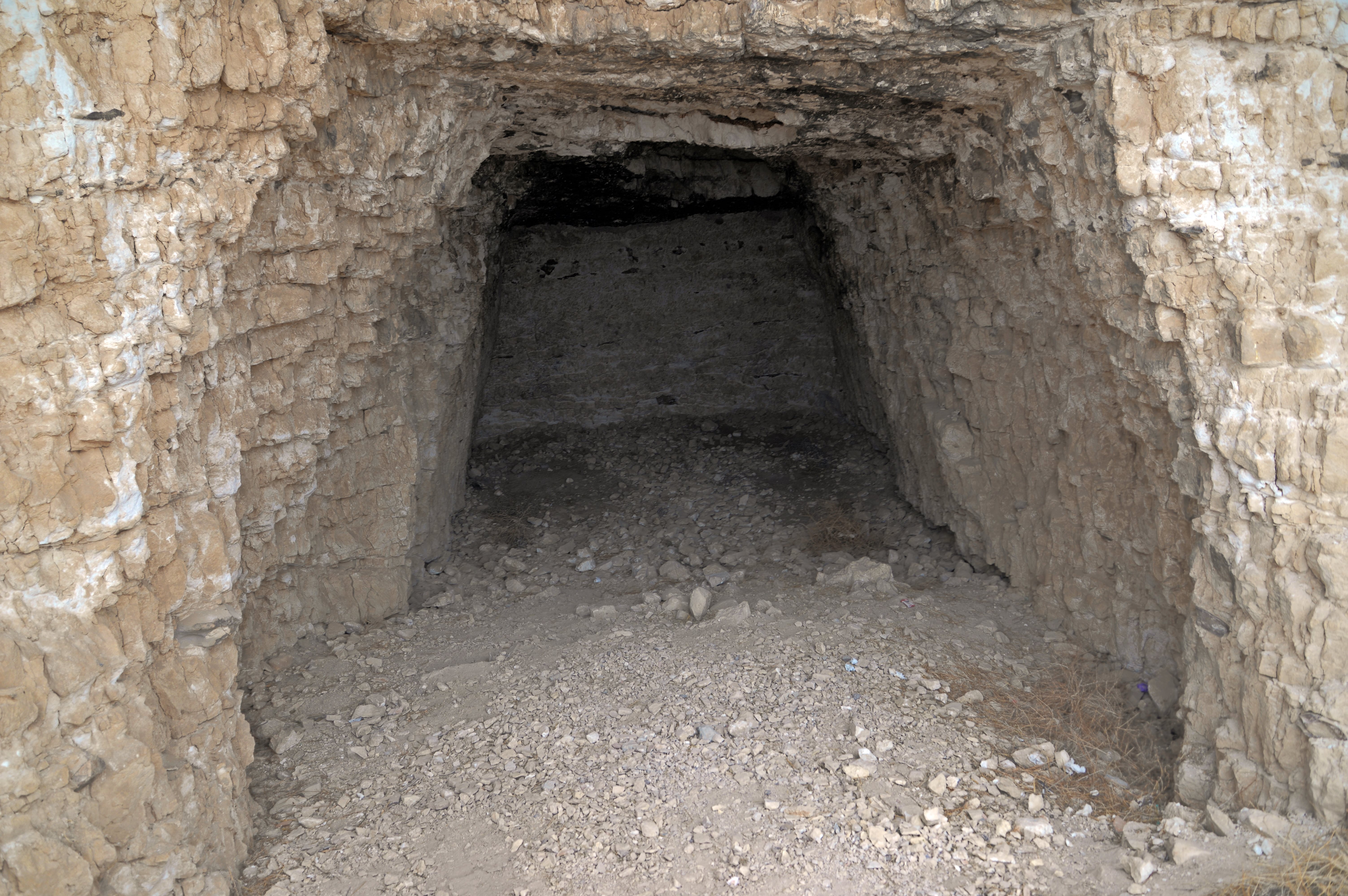
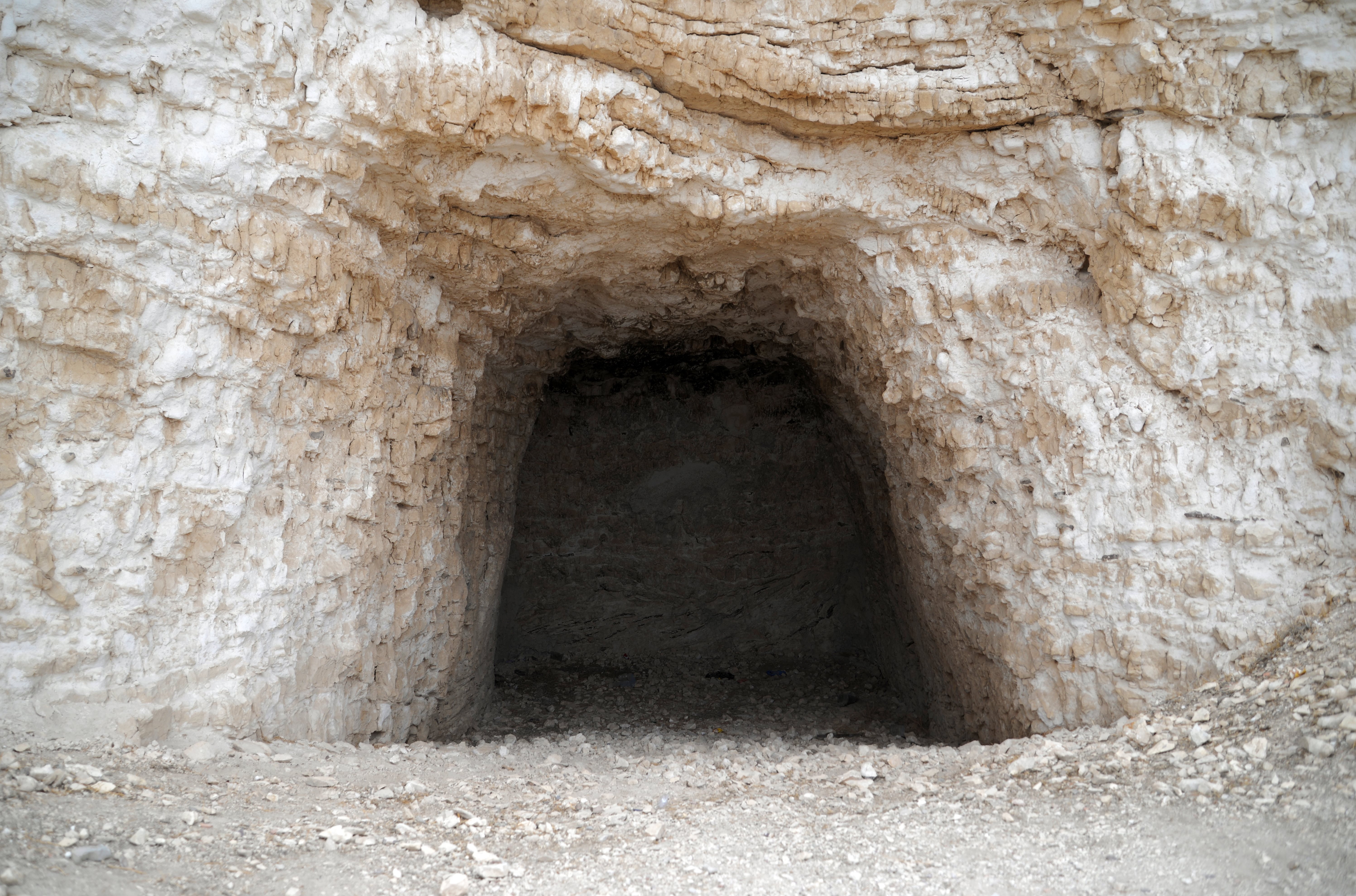
(c) Eastern Cisterns
Along the eastern side of the mountain are five cisterns. We stopped at two of the cisterns.
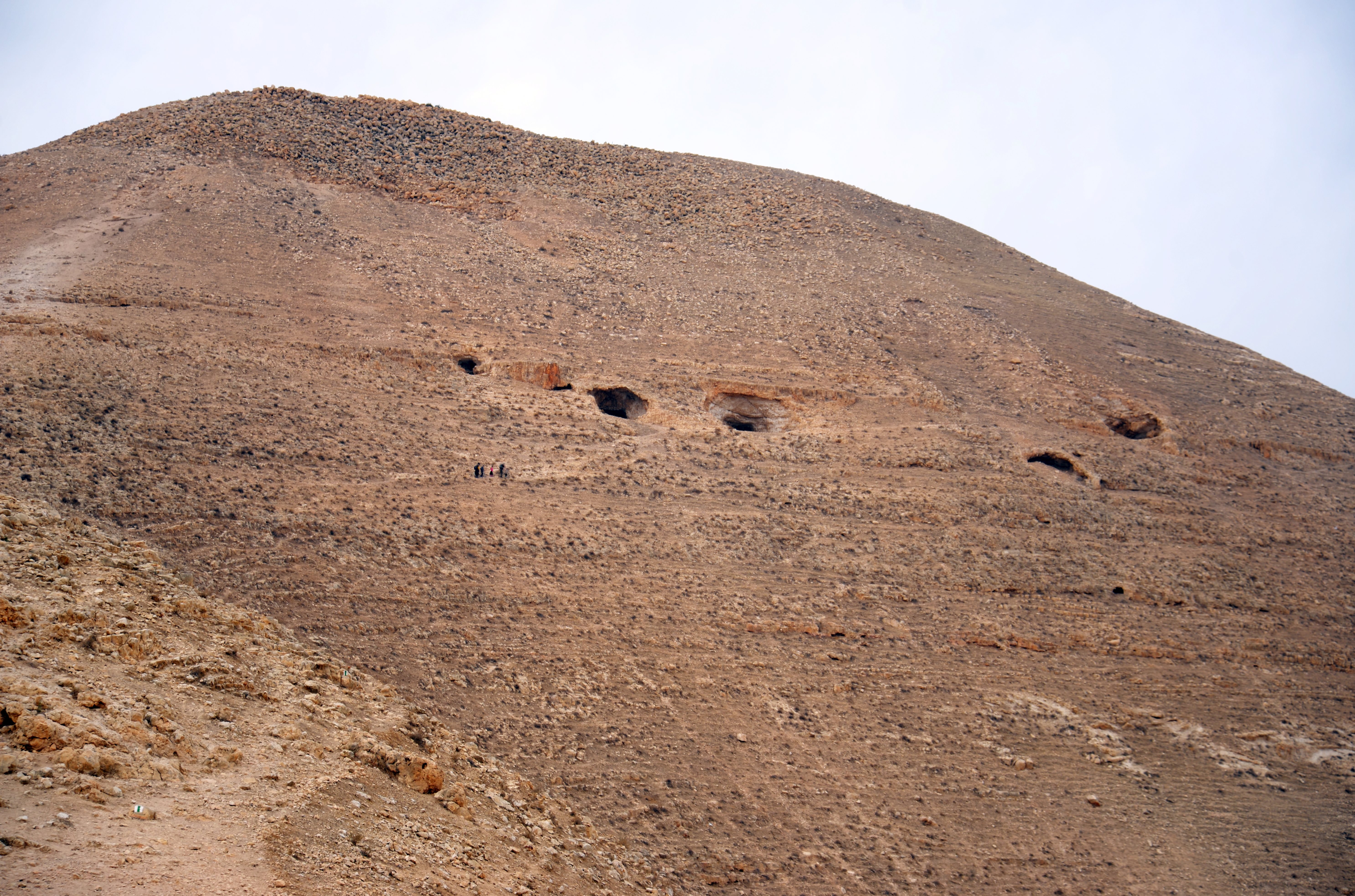
Below – the the first (southern) cistern. These cisterns were massive—some reaching depths of over 10 meters—and were coated with thick hydraulic plaster. The cisterns are plastered to keep the water from sipping out of the reservoir and to make smooth so it will be possible to clean it. The cisterns were filled from runoff water from the fortress above them, and three of them from the long aqueduct.
The water supply system of Sartaba is considered one of the most impressive engineering feats of the Hasmonean and Herodian periods. Because the fortress sits on an isolated, arid peak with no natural springs, its survival depended entirely on the sophisticated collection of seasonal flash floods (wadis). The sophisticated hydraulic system of Sartaba is a two-layered marvel. Originally engineered by the Hasmonean King Alexander Jannaeus to withstand prolonged sieges, it was later expanded and refined by Herod the Great.
Another cistern is in the following photo.
The water supply system did not rely on a permanent river. Instead, it tapped into the Wadi Qara and Wadi Shubeish to the west. Engineers built dams across these desert stream beds. During the brief winter rains, the massive rush of water was diverted into a primary channel before it could wash away into the Jordan Valley. Before entering the main aqueduct, the water passed through “settling basins” where sand and silt could drop to the bottom, ensuring that the water reaching the fortress was relatively clear.
The aqueduct stretched approximately 4 kilometers from the diversion points to the base of the Sartaba hill. The channel maintained a very slight, consistent downward slope. This required precise surveying to ensure the water flowed steadily without gaining enough speed to erode the lime-plaster lining. There is ongoing debate among archaeologists about how the water crossed the deep saddle between the western hills and the Sartaba peak itself. Some suggest a bridge (ashlar-built) while others look for evidence of a pressurized “inverted siphon” system, similar to those found in Jerusalem and Hippos.
Because the summit was too high for the water to reach via gravity alone, the system was divided into two levels. The aqueduct emptied into a massive cluster of rock-cut cisterns at the foot of the “conical” part of the hill. These cisterns were massive—some reaching depths of over 10 meters—and were coated with thick hydraulic plaster. From these lower reservoirs, water had to be transported to the summit palace by hand or by pack animals (donkeys and mules) following a steep, winding path. This ensured that the elite in the palace had a constant supply of fresh water for their bathhouses and gardens, even in the height of summer.
This water system changed Sartaba from a simple lookout post into a habitable royal residence. With millions of liters stored in the 14 cisterns found in 3 height levels around the hill, the fortress could withstand a siege lasting months or even years, as the Roman general Gabinius discovered during the Hasmonean revolts.
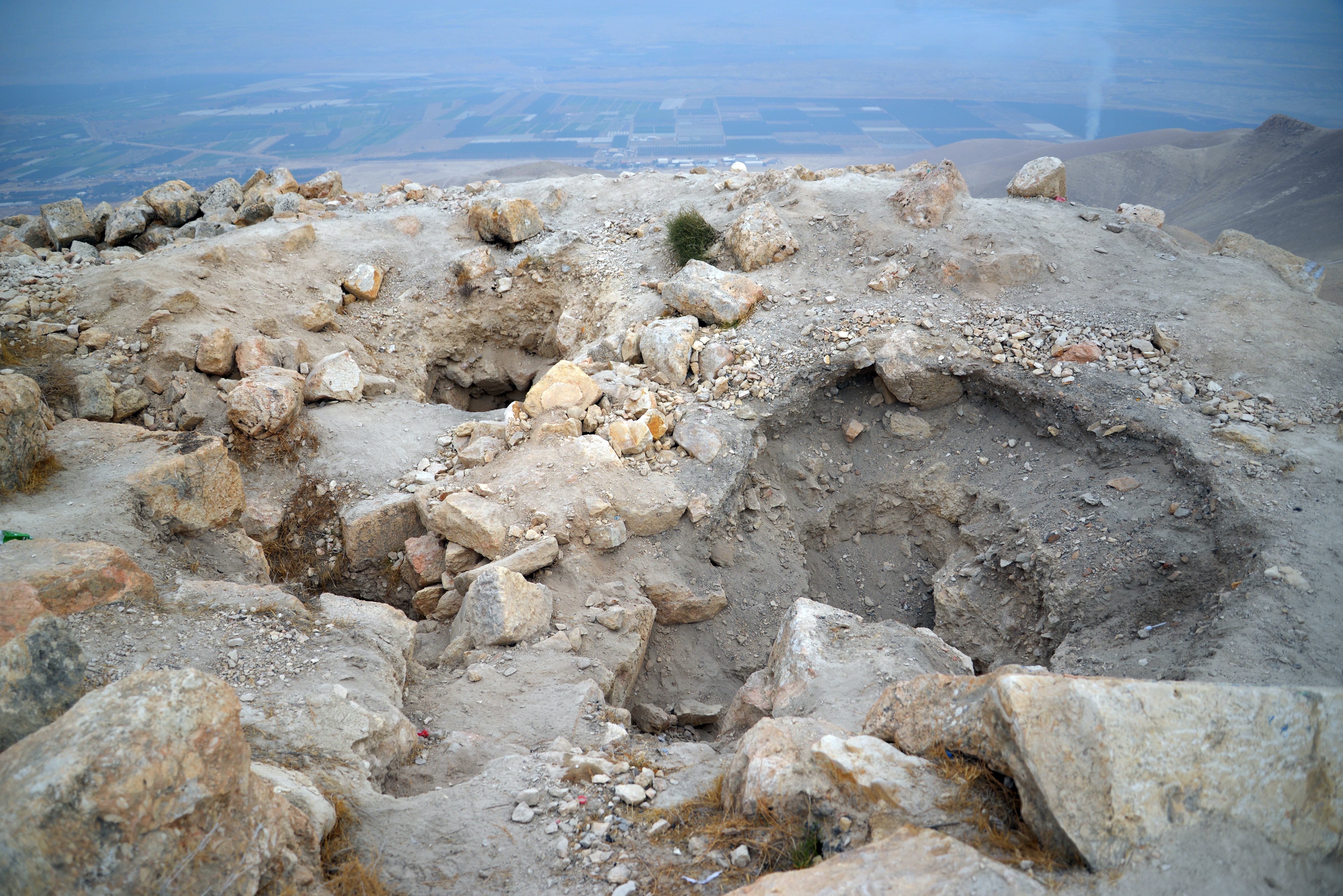
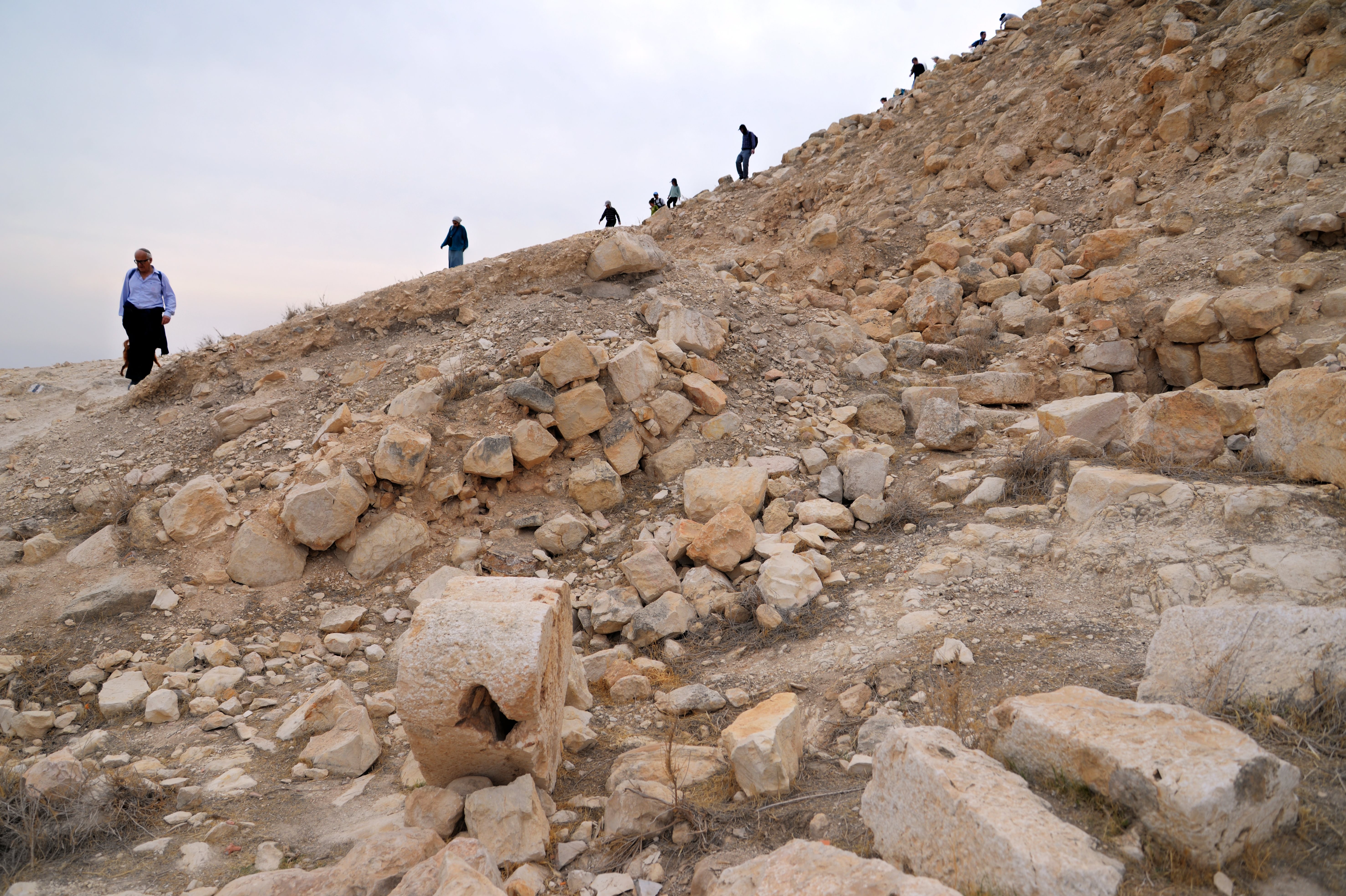
(d) Hasmonean fortress
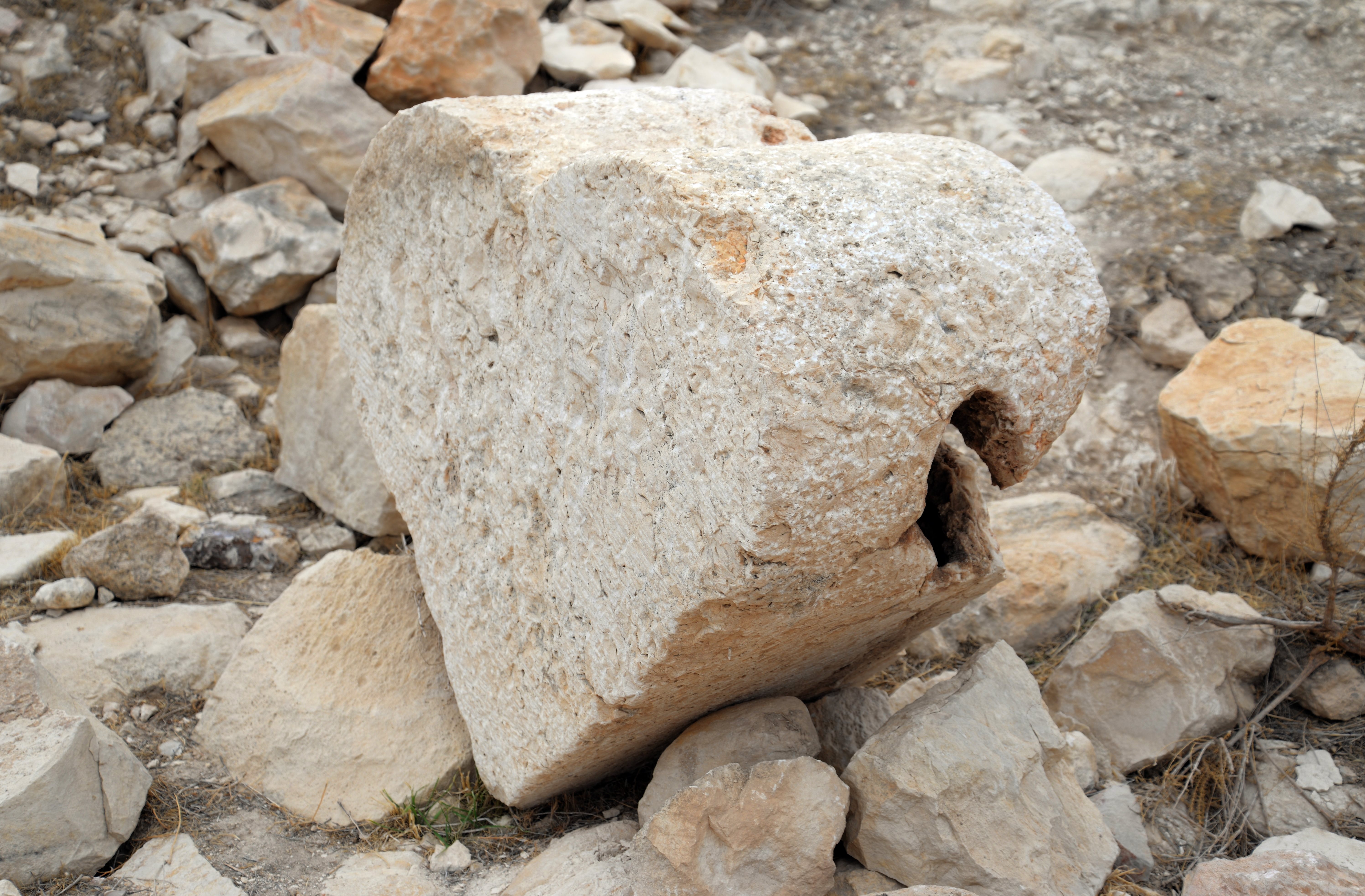
On the summit are remains of the Hasmonean fortress. The Hasmonean fortress was situated on an irregular, elongated summit measuring roughly 95m by 40m. The highest point on the southern half was occupied by a massive central tower or “donjon”. This was the core of the Hasmonean stronghold, used as a treasury and a final defensive refuge. The Hasmonean fortress was concentrated primarily on the southern portion of the summit’s elongated platform.
The fortress on the south end of the summit covered an area of 20m by 30m. It was built in 4 connected areas, narrowing from north (the head tower, 20m by 20m) to south (the tail supporting tower, 5m by 5m). A suggested reconstruction of the base of the walls of the fortress and the compound is shown in the following illustration, based on diagrams of previous surveys.
Only the south western wall survived and is still standing. The wall is 2-3m high with ~8 visible courses of stones. Below is the surviving south side of the fortress, where 2 sections of the building are seen from north to south: a wider area on the left, and a narrow area on the right.
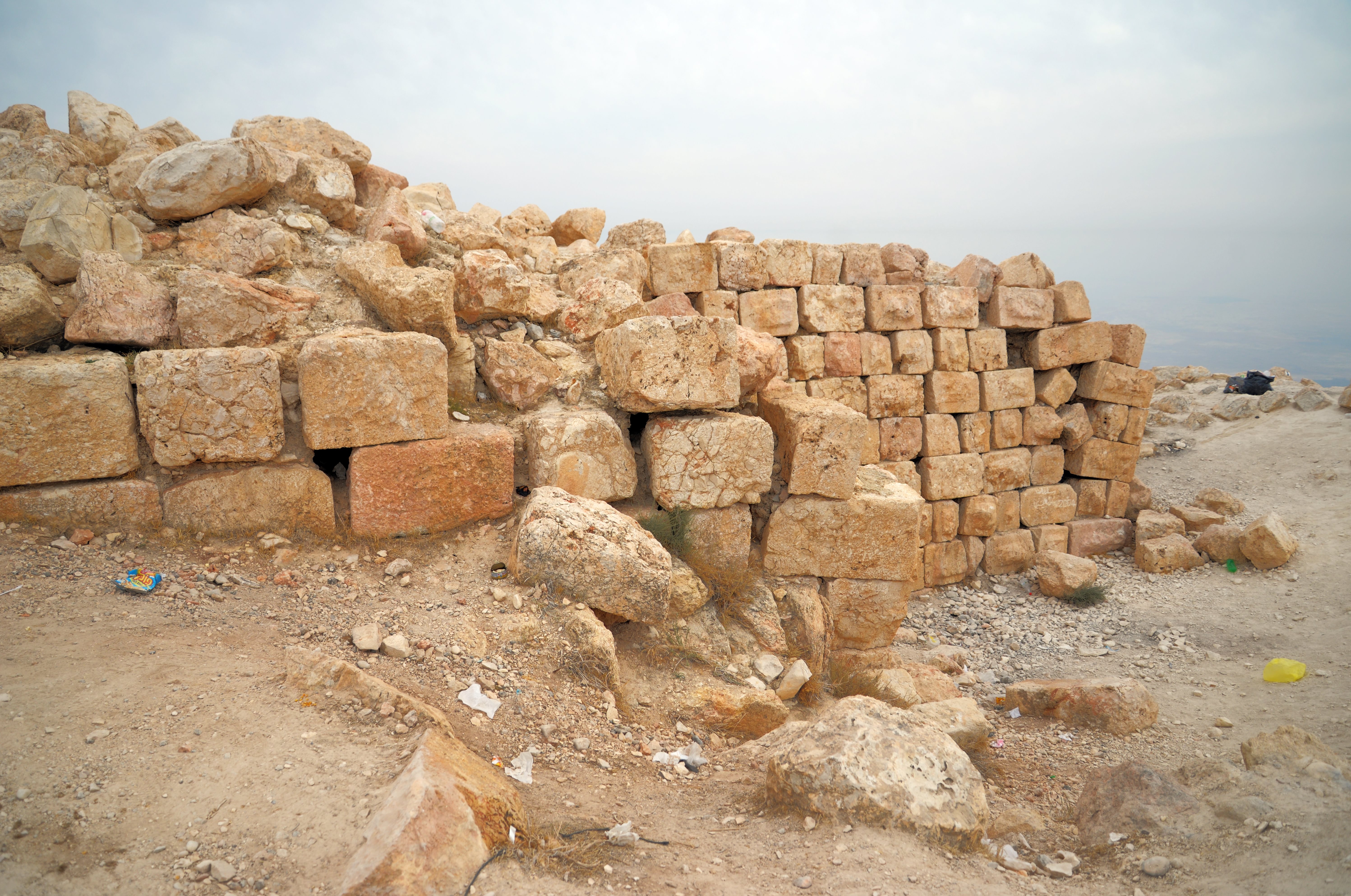
The next photo shows the same area, but with a view from south to north.
The walls are meticulously built of large, heavy stones, with a chiseled boss typical of this period. The stones were laid using the “heads and stringers” (ראשים ופתינים) method, a construction method typical of that period.
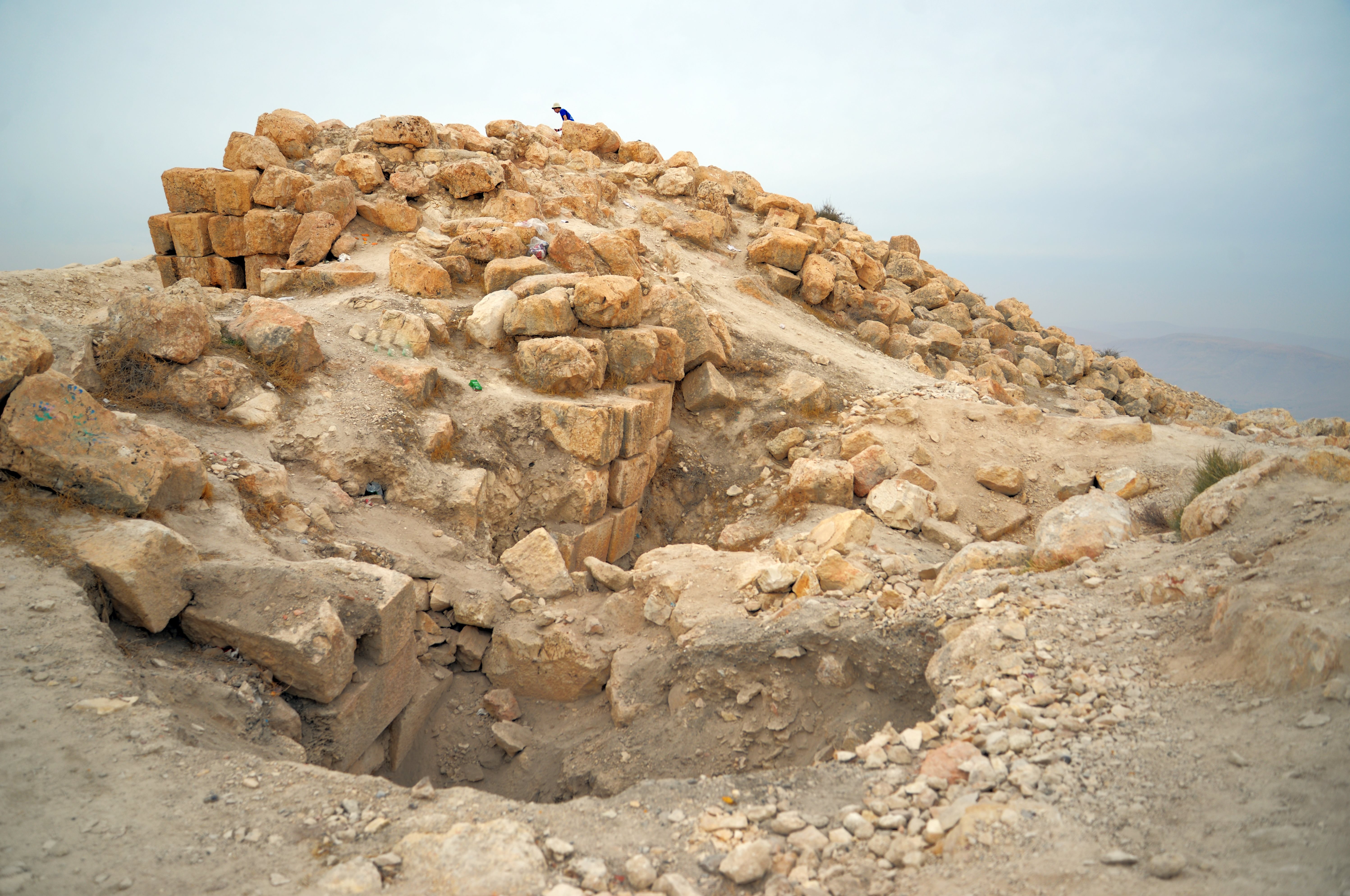
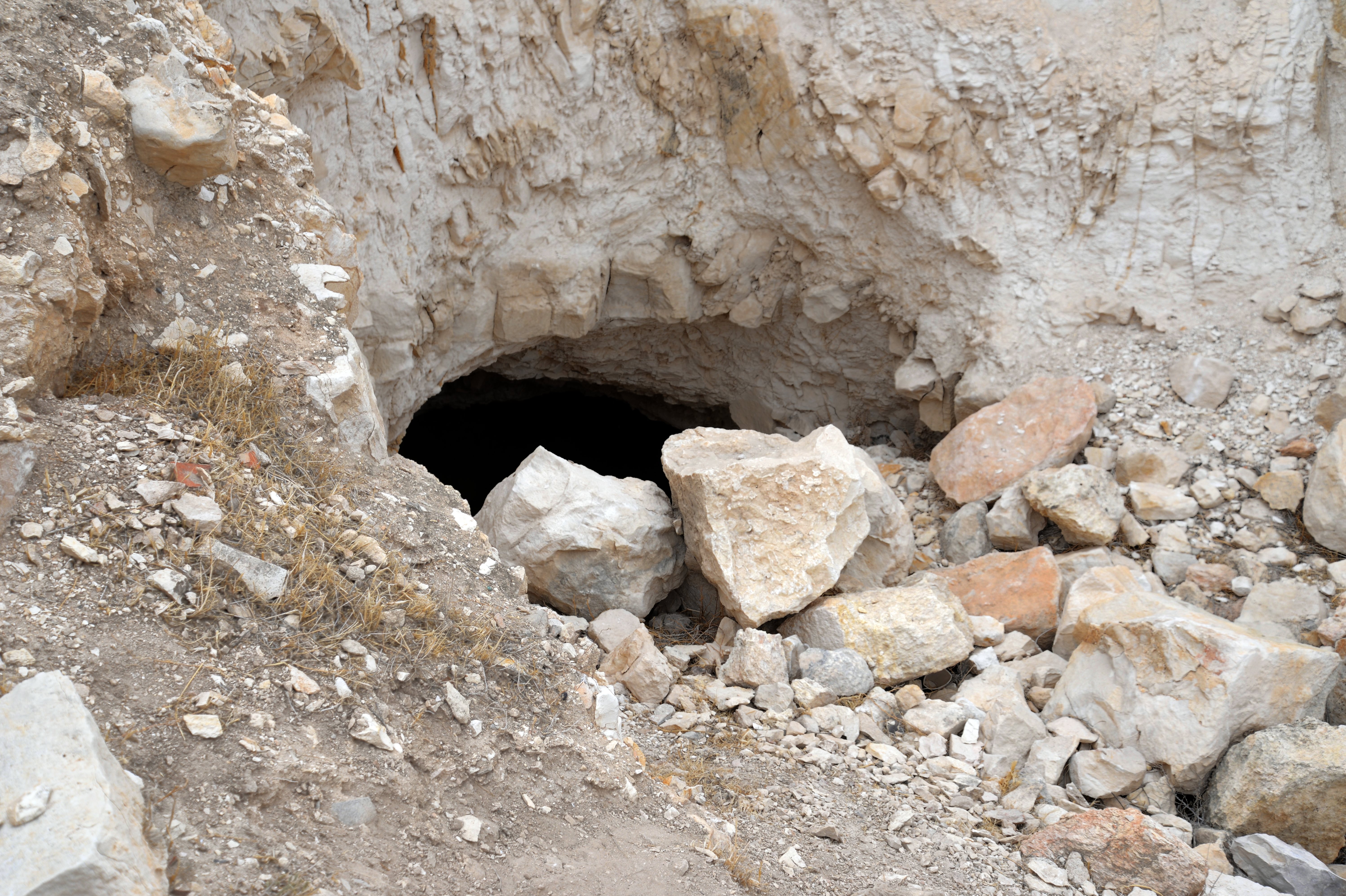
An illicit digging, probably done during the middle 19th century, created a deep cavity on the south west side of the wall, as seen at the bottom of the wall. Five other holes were cut in the north side of the summit. Probably these digs were intended to attempt a recovery of a treasure that was presumably left buried in the fortress, as Sartaba served as a treasury for the Hasmonean kings.
The “bossed” Hasmonean stones that are seen at the site today are the very walls that Aristobulus’s soldiers were manning as they watched Pompey’s legions approach from the valley floor.
The entrance to the fortress was apparently on the western (Samaria) side.
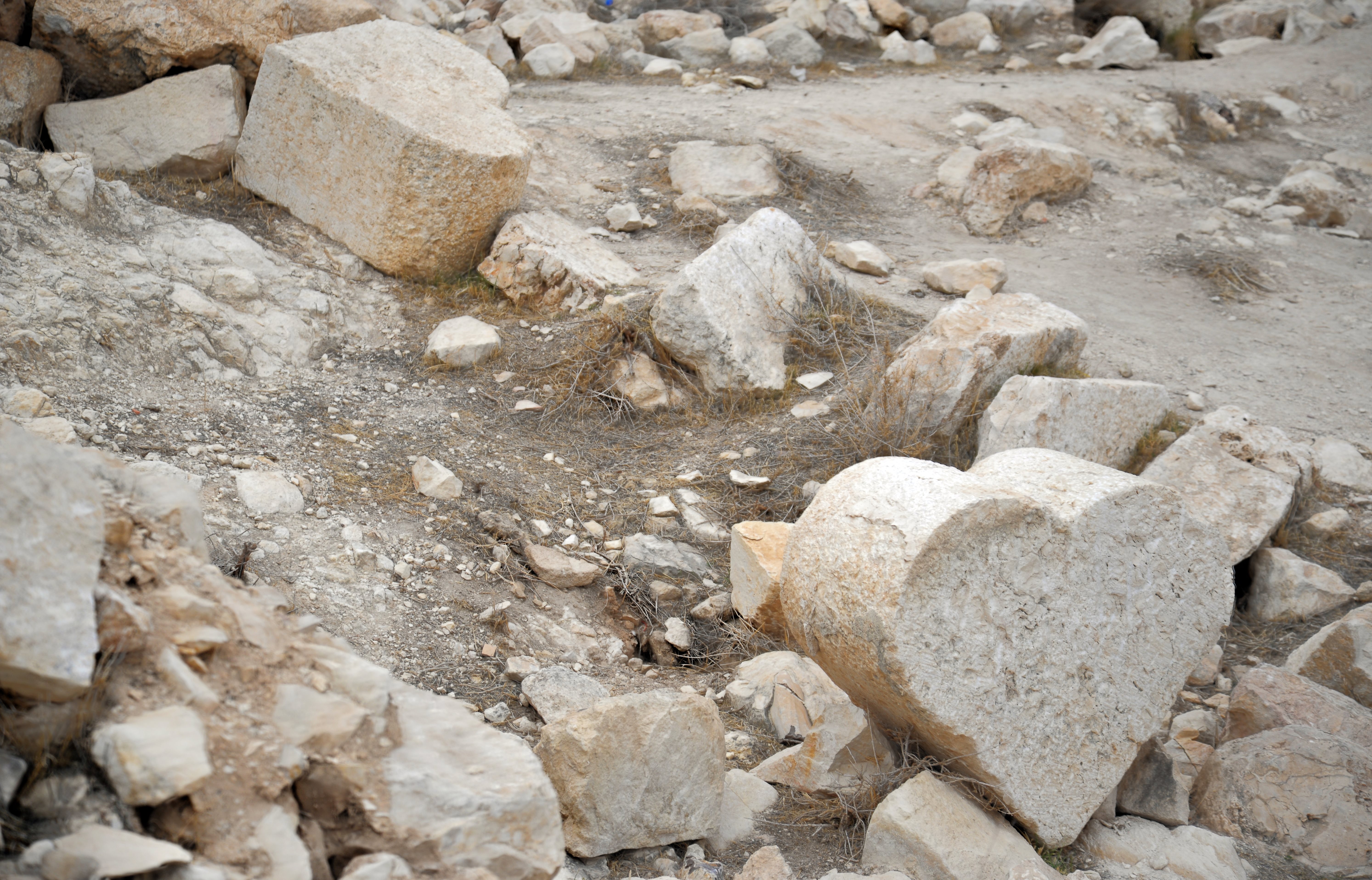
Other remains of the fortress are seen on the top of the summit. The following photo shows the area south of the fortress.
There were illicit digging on the area that could have damaged the remains.
In the next photo – the eastern slopes just below the summit.
The higher side of the eastern foothill was probably built during the Hasmonean period. However, today it is totally leveled. This also could have been the effect of earthquakes that caused the remains of the Hasmonean walls to slide down the eastern side of the hill as as seen today in the following photo.
In 57 BC the Roman general Gabinius demolished the fortress to prevent it from being used as a base for Jewish nationalist rebels. Gabinius didn’t just capture the fort; he systematically dismantled the walls. This could be why archaeologists find many of the massive Hasmonean stones with their distinct “bosses” tumbled down the slopes.
(e) Herodian Palace
The destruction of the Hasmonean fortress paved the way for Herod the Great. Decades later, Herod “inherited” a ruined summit, allowing him to build his brand-new, Roman-style palace from scratch on top of the Hasmonean foundations.
The peristyle hall Herod the Great constructed atop Sartaba (Alexandrium) represents the pinnacle of his “desert luxury” architecture. While the Hasmoneans built for survival, Herod built for prestige, importing the Roman concept of a peristyle—a continuous porch formed by a row of columns surrounding a courtyard.
The structure was located on the uppermost “terrace”, 40m below the peak. It was a rectangular or square open-air courtyard surrounded on all four sides by covered colonnades. This created a shaded, breezy walkway that was essential for comfort in the intense Jordan Valley heat. The central area (the atrium or viridarium) likely contained a small ornamental garden or a shallow pool, which served as a status symbol in such an arid location.
The hallmark of this hall was its Doric-style columns. The four corners of the hall featured unique heart-shaped piers. These supported the heavy weight where two rows of architraves met, ensuring the roof remained stable during the high winds often felt at the summit. The columns were not made of marble. Instead, they were built of local limestone drums and coated in a thick, brilliant white stucco. This plaster was often fluted (grooved) to mimic the expensive stone used in Rome, then painted or polished to a high shine.
Herod didn’t just build the skeleton; he imported the “Interior Design” trends of Rome. The walls behind the columns were decorated with vibrant frescoes. Based on fragments found at the site, these were done in the Second Pompeian Style, which used perspective painting to make walls look like they had windows looking out onto landscapes or architectural vistas. The floors of the walkways were likely paved with geometric black-and-white mosaics, similar to those found in Herod’s palace at Masada and the nearby Jericho winter palaces.
Because the peak of Sartaba is so narrow, Herod’s engineers had to extend the surface area to fit a grand hall. On the west side the engineers cut into the mountain, while on the east side they extended the area by building massive retaining walls and vaulted underground chambers (substructures) to create a flat, artificial platform—a podium. This allowed the hall to appear as if it were floating on the very tip of the mountain.
The fortress on Sartaba was like a “Phoenix Fortress”. It was built by the Hasmoneans, leveled to the ground by the Roman General Gabinius in 57 BC, only to rise again even more grandly under Herod the Great twenty years later. This cycle of destruction and rebirth is what gives the site its complex layers of masonry today. Remains of the Hasmonean level were found under the Herodian peristyle.
From Dr. Raviv’s summary of the 2025 excavation: “Among the finds from the excavations of the Peristyle – a variety of imported Herodian vessels, including red-slipped tableware of the Eastern Terra Sigillta type and fragments of wine amphorae, dozens of fragments of stucco and fresco in black, green, red and yellow colors that decorated the Hasmonean and Herodian palaces, botanical finds including fruits and seeds, as well as animal bones – sheep/goats, cattle, chickens and fish!”.
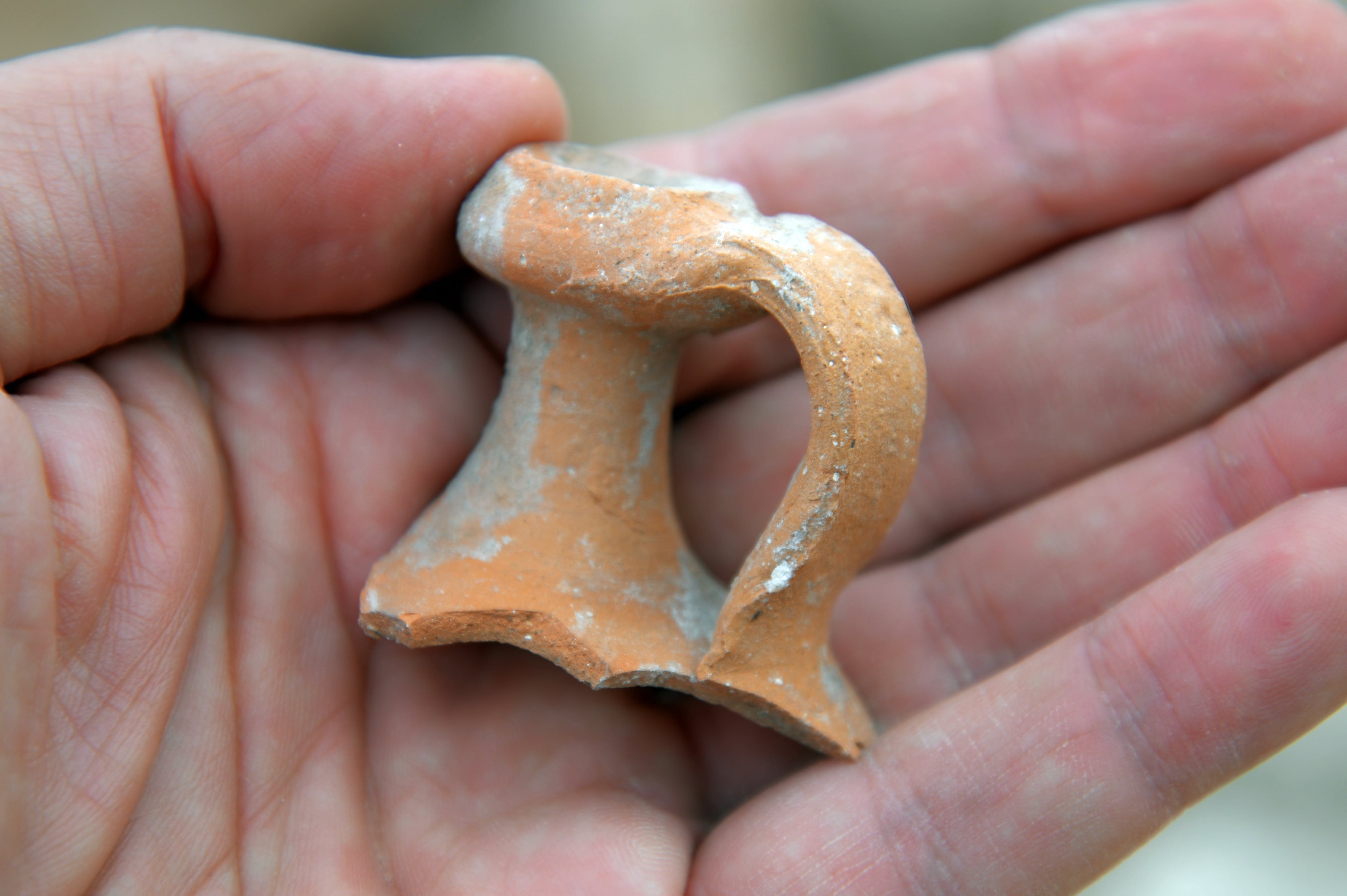
In the rubble, probably fallen from the Hasmonean fortress above the Herodian palace, are fragments of pottery sherds. This storage jar seen in this area is typical of the Hasmonean or Early Herodian period.
(f) Heart Shaped columns
Unique double-columns found at the corners of the Herodian peristyle. Among the scattered ruins on the summit of Sartaba, in the rubble of the Herodian palace, the most striking architectural finds are the “heart-shaped” column drums. These are not merely decorative; they were a specialized functional element used to solve a specific structural problem in classical peristyle (colonnaded) courtyards.
In a standard Roman colonnade, a single round column works perfectly for a straight line. However, where two rows of columns meet at a 90-degree corner, a single round column often looks “weak” or fails to align correctly with the beams (architraves) from both sides. Herodian engineers created a “double-column” by carving two semi-circular engaged columns onto a single, solid square pier. When viewed from above (the cross-section), the block resembles a heart. The flat, interior corner allowed the roof beams to meet securely, while the rounded exterior faces maintained the elegant visual rhythm of the surrounding round columns.
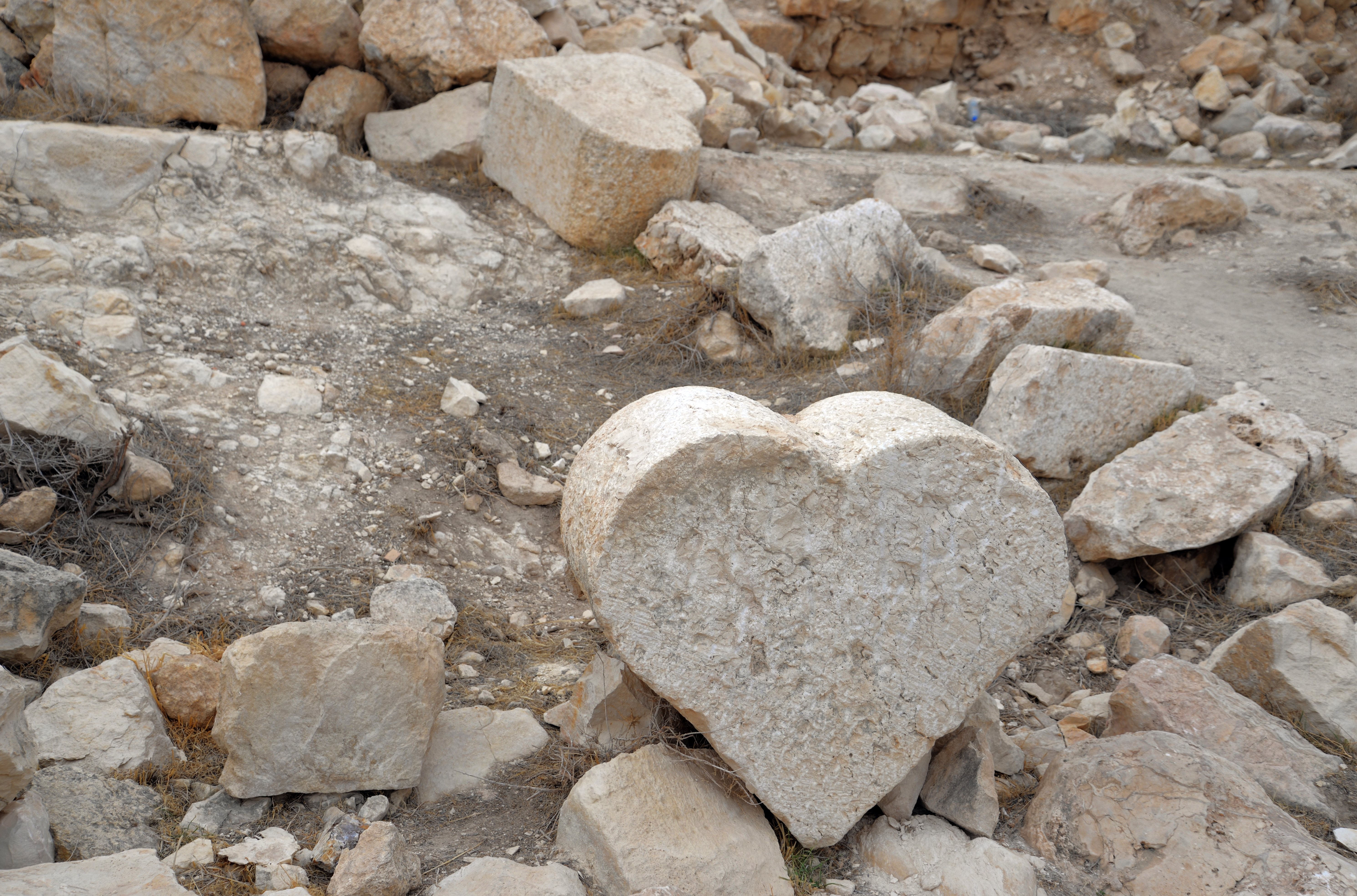
The presence of these columns at Sartaba is a clear “architectural signature” of Herod the Great. These columns were difficult and expensive to carve. Their presence on this remote, desert peak proves that Herod didn’t just want a fortress; he wanted a palace-fortress that rivaled the luxury of Rome. At Sartaba, these drums were carved from local limestone and originally covered in high-quality white stucco, which was then fluted to give the appearance of expensive marble.
Similar heart-shaped column drums are found in other Herodoian palaces: Herodium – Upper Fortress Courtyard; Masada Northern Palace (Middle Terrace); and Jericho – Third Winter Palace.
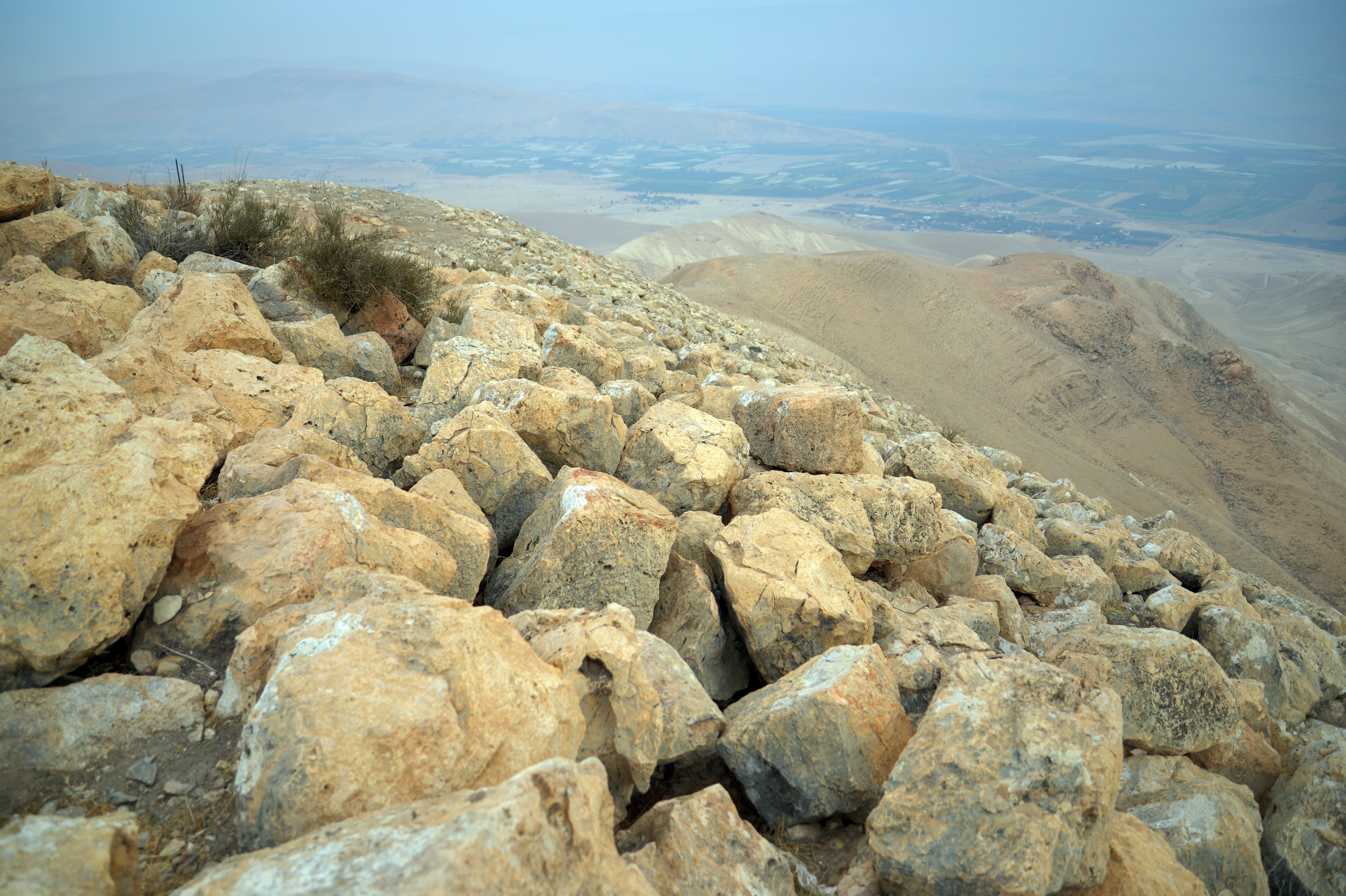
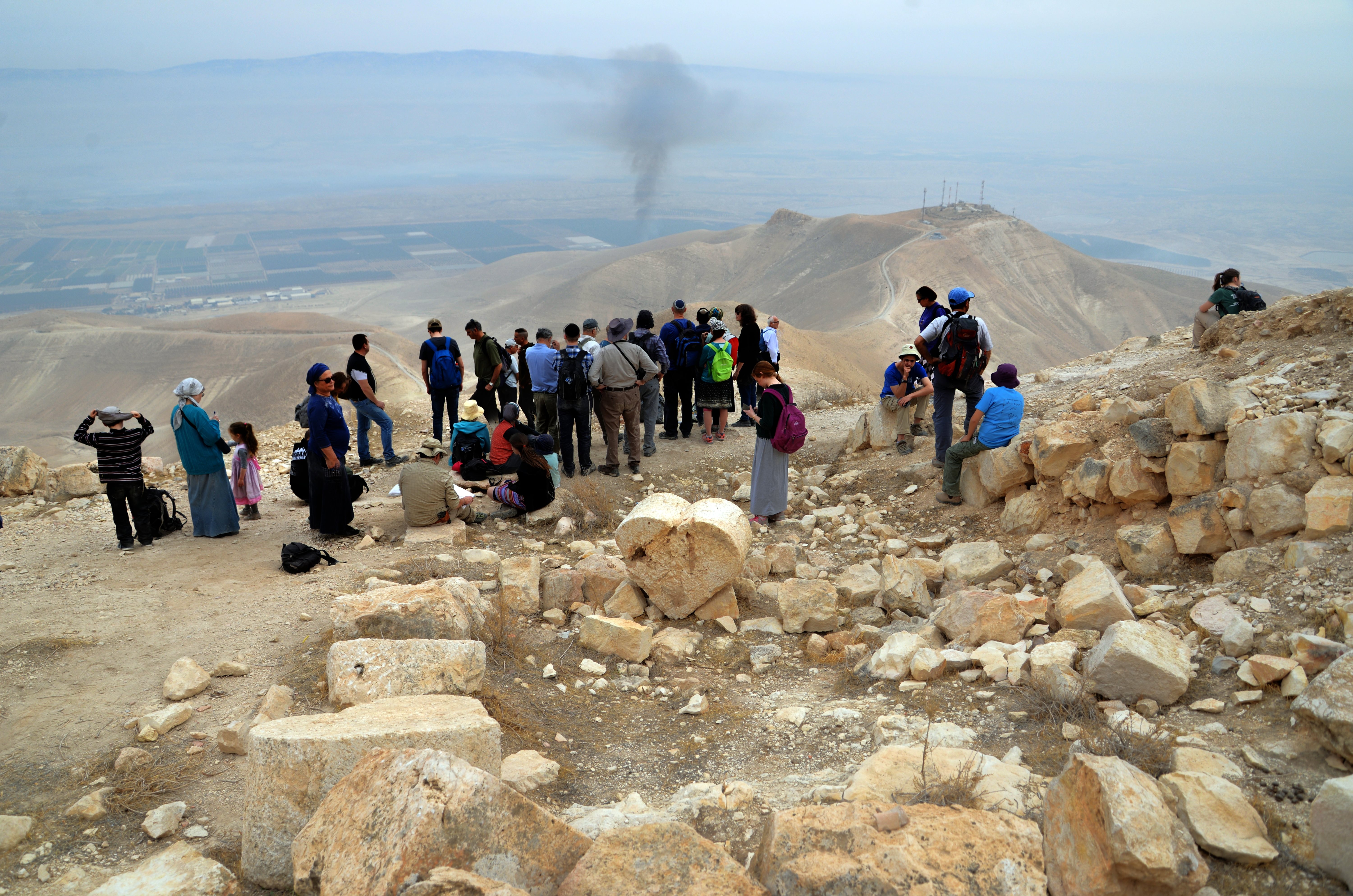
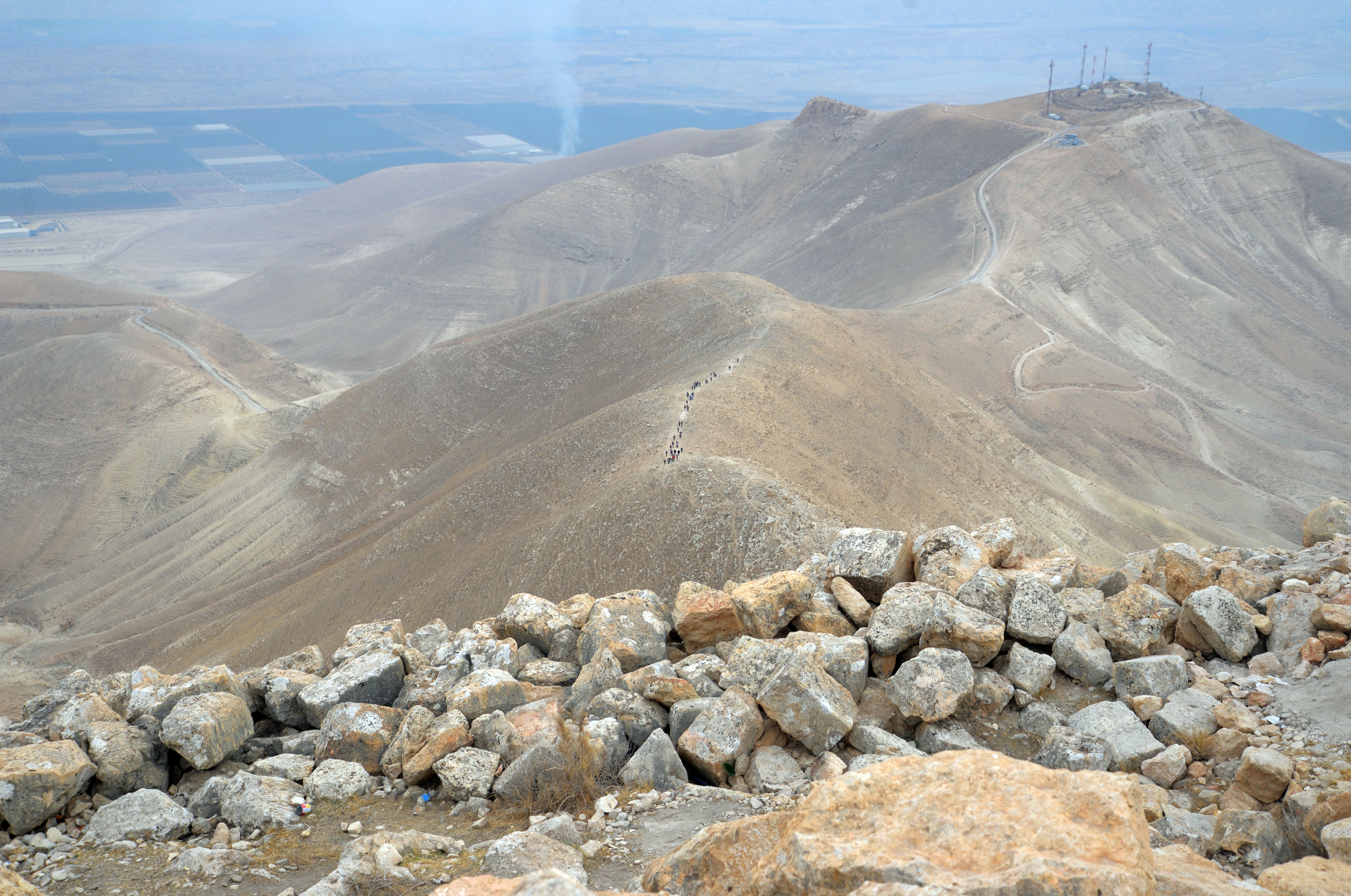
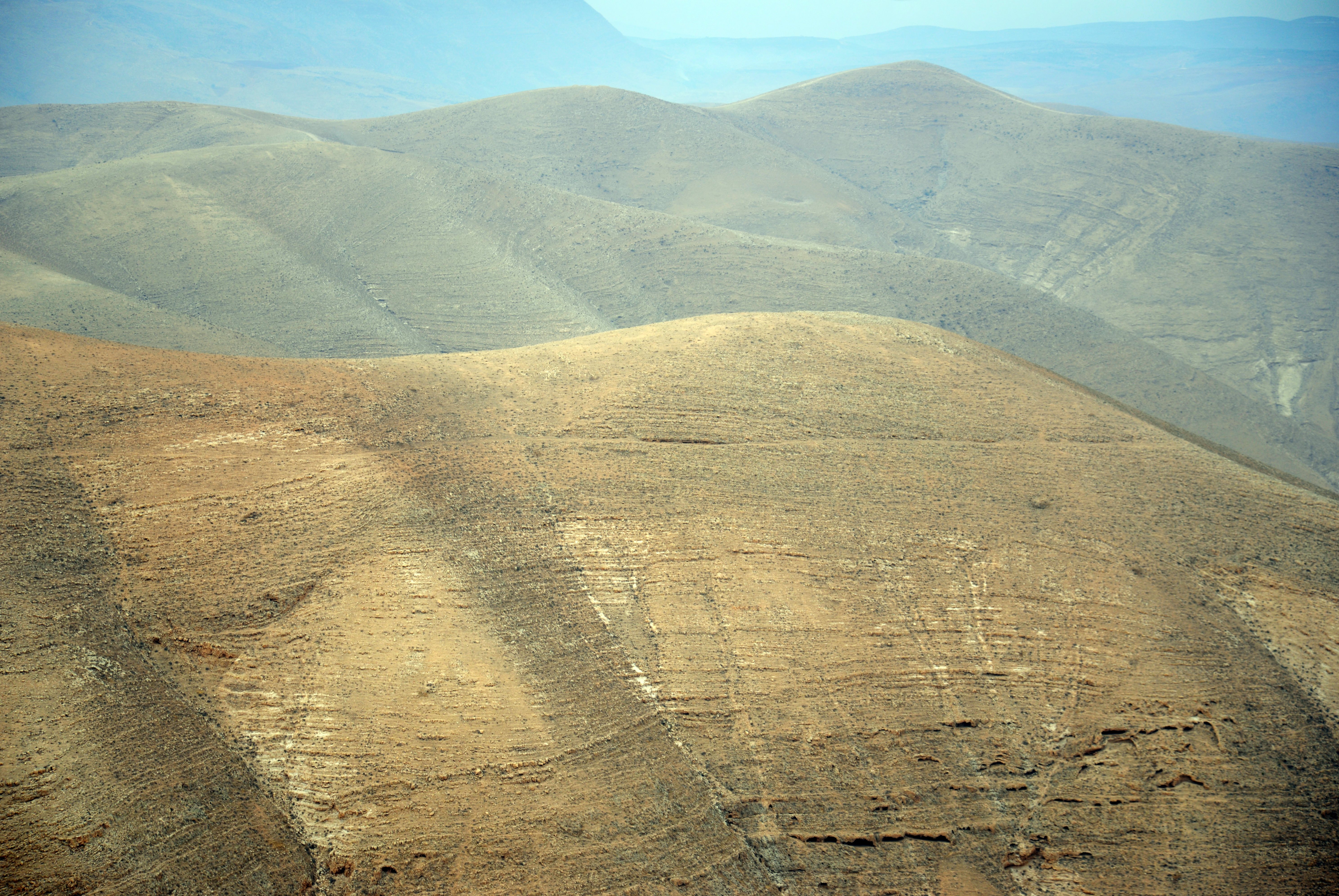
(g) Commanding views
From the fortress are great views of the area, since the hill rises considerably over its surroundings. This view is towards the south. The Jordan valley is seen in the far background. The trail that descends to the paved road is below, and a column of persons are seen walking along the trail.
Next is a westward view towards Samaria. Just below is the foothill of the fortress.
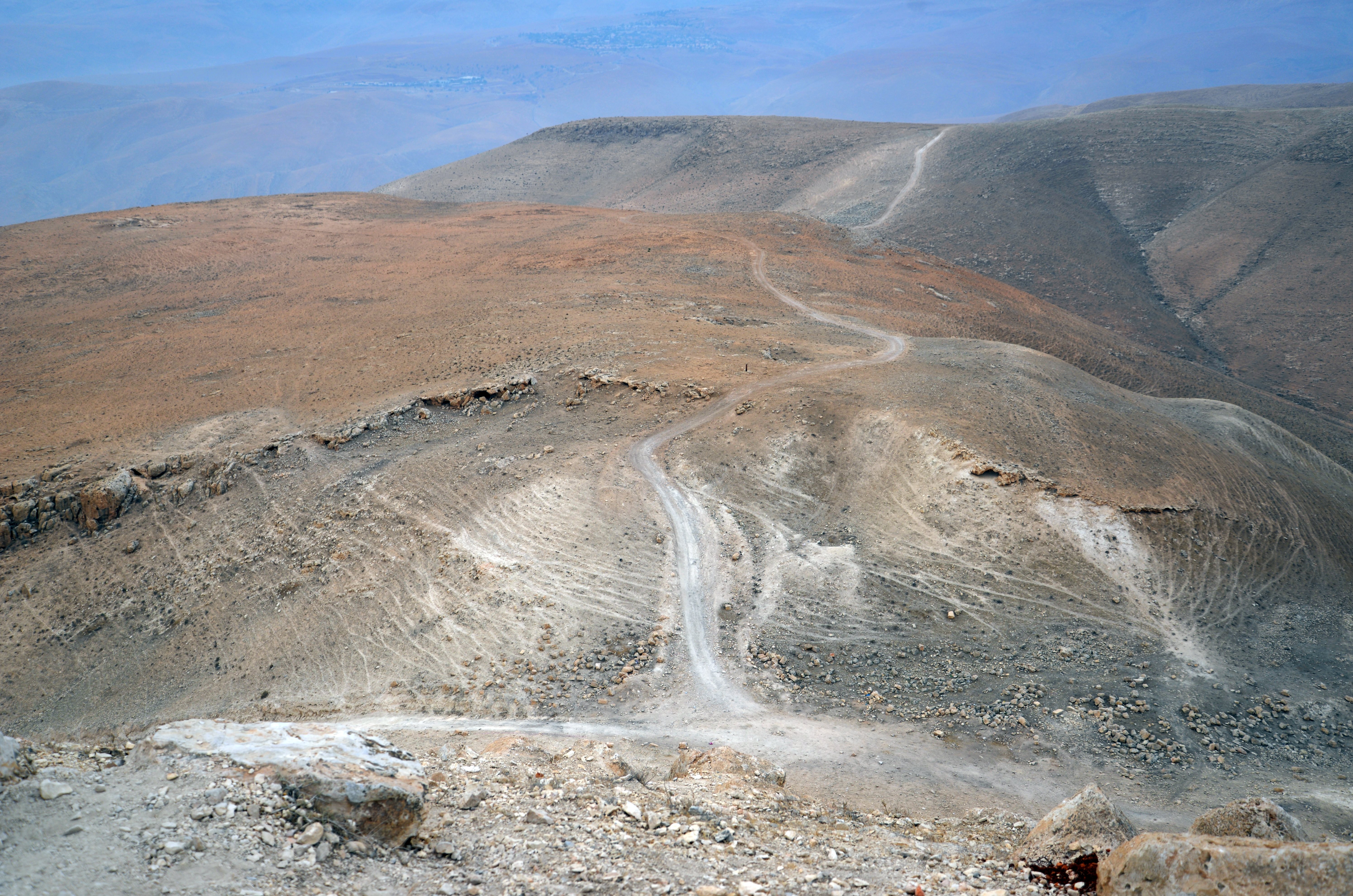
And another view towards the north:
Video Tour
Tour the site with this video:
Etymology – behind the name:
* Names of the site:
- Sartaba – (in Aramaic סרטבא) This name is frequently mentioned in the Mishnah and Talmud as a beacon station for transmitting signals.
- Some scholars have suggested a potential link to the biblical city of Tzartan or Zaretan (צָרְתָן), mentioned near the location where the Israelites crossed the Jordan River, although this connection is considered uncertain by many researchers.
- Another proposal was that the name is based on the word “commander of the army” – Sar Tsava (שר צבא). This aligns with the site’s primary function as a strategic military outpost and a treasury for the Hasmonean kings, who were themselves the commanders-in-chief of the Judean forces.
- Qarn Sartaba – Arabic: horn of sartaba (Qarn refers to the distinct, pointy shape of the mountain)
- Keren Sartaba – Hebrew for “Horn of Sartaba”, based on the Arabic name and/or the shape of the mountain.
- Kürn Sürtübeh (on PEF map)- the peak of Sürtübeh (from Aaramaic סרטבא)
- Alexandrion, Alexandrium – Alexander Jannaeus named the site Alexandrium after himself (or potentially his father, John Hyrcanus I, whose Hebrew name was also Alexander).
Links:
* External links and references:
- Sartaba in the “The Manasseh hill country survey” Volume 4, pp. 476-490 Site 173 [Adam Zertal , 2012] – great review
- Sartaba in the “The new encyclopedia of archaeological excavations in the Holy Land”, Volume 3 pp. 1133-1136 [1992 E. Stern editor]
- West Bank digs reignite debate over land and history | The Jerusalem Post, March 2026
* BibleWalks sites:
-
- Rujm es Si’a – Hasmonean period fortress on route to Sartaba
- Adam bridge – Jordan river crossing at the foot of Sartaba
- Horkania – another Hasmonean desert fortress
BibleWalks.com – “Arise, walk through the land in the length of it and in the breadth of it…”
Horvat Hemed <<<—previous site—<<<All Sites>>>— next site—>>> es Suwede Roman camp
This page was last updated on May 6, 2026 (add link)
Sponsored Links: