Ruins of a fortress and road station, guarding the ascent to Sartaba (Alexandrium).
Home > Sites > Samaria > Rujm es Si’a
Contents:
Overview
Aerial Map
History
Photos
* Hasmonean station
* Byzantine Estate
* Flight Over
Video Tour
Etymology
Links
Overview:
At Rujm es Si’a, 0.5km north west of Masu’a, are ruins of a fortress and road station. It guarded the northern ascent to Sartaba along the valley of Juruzliya. During the Byzantine period the site was a fortified estate. Recent excavations unearthed earlier Hasmonean period installations and structures, as well as a hoard of Hasmonean coins.
Map / Aerial View:
An aerial map is shown here, indicating the major points of interest around the site. The place is south of Gadi camp, and west of community of Masu’a, at the entrance of the valley of Juruzliya.
History:
- Biblical periods
Pottery surveys dated 15% of the sherds to the Iron II period. Therefore, the tower and adjoining structures could have had an earlier stage of this period.
The cities and roads during the ancient periods up to the Roman period, are indicated on the Biblical Map below. The site is indicated as a red square. Its location is close to the Jordan valley, to the North-South route, and to the Jordan river crossings. An ancient east-west route passed on the north side, ascending to heart of Samaria and the city of Shechem.
North of the site, in the center of the Tirzah (Far’ah) valley, was a large multi-period city of Coreae (identified at nearby Tell es-Simadi or Tell el-Mazar).
Map of the area – during the Israelite to Roman periods (based on Bible Mapper 3.0)
- Hasmonean/Early Roman period
The Hasmonean King Alexander Jannaeus (104-77 BC) built a formidable desert fortress on its summit. Jannaeus named the site Alexandrium after himself (or potentially his father, John Hyrcanus I, whose Hebrew name was also Alexander). It served as one of a string of Hasmonean “desert castles” that protected the eastern border of Judea and secured the vital route between Jerusalem and the Jordan Valley.
During the Roman period, Sartaba—known in Greek and Latin as Alexandrium—was one of the most formidable and strategically significant desert fortresses in Judea. Perched atop a distinctive conical peak 379 meters above sea level, it commanded a 360-degree view of the Jordan Valley and the road to Jerusalem.
There were 3 routes that ascended to Sartaba – from North, West and South. Rujm es Si’a was built as a road station to protect the Northern route. The site served a road station along the route ascending from the Tirzah valley, along the Kurzeleiyeh (or Juruzliya) valley.
The site is 1.8km south of Tell es-Simadi (or Tell el Mazar), an ancient city in the Tirzah valley that scholars identify as Coreae. Coreae is mentioned in Josephus accords of Pompey the Great’s Invasion (63 BC), Rebellion of Alexander (57 BC), and Vespasian’s Campaign (68 AD). This city was associated with Alexandrium/Sartaba.
A hoard of 160 Hasmonean coins, dated to King Alexander Jannaeus, were found in the excavations of the site. They were minted in 80 or 79 BC. They were found by a collapsed wall in the food preparation area of a building.
According to the excavators, the site was orderly abandoned during the middle of the 1st century BC.
- Roman period
Roman general Gabinius demolished Sartaba in 57 BC to prevent it from being used as a base for Jewish nationalist rebels.
Sartaba was later rebuilt by Herod the Great, who transformed the rugged Hasmonean outpost into a magnificent palatial retreat. Although Zertal’s survey dated the site to the Roman period, recent excavations found that there was no Herodian (Early Roman) period layer at Rujm es-Si’a.
After the 1st century AD, following the Great revolt at 70 AD, the site of Sartaba was abandoned.
- Byzantine period
During the Late Byzantine period (6th-7th century AD) a large rectangular structure was built on the north side of the Hasmonean complex. It was built over massive supporting walls, covering the center of the site and possibly covering sections of the Hasmonean site. Additional courtyards were built on the western and eastern sides of the tower.
An AI generated illustration shows a figurative view of the Byzantine period site from the south east side. It consists of a small fortress located on a hill, a number of houses on the eastern side (seen here), and another section on the western side (hidden by the hill). The route to Sartaba passed on the eastern side of the fortress.
Illustration of Rujm es Sia during Byzantine period – AI generated Credit: ChatGPT AI / BibleWalks Collection
- Ottoman Period – (1516-1918 A.D.)
Conder and Kitchener of the Palestine Exploration Fund (PEF) surveyed the area during the Survey of Western Palestine (SWP) in 1874-75. This is a section of their map, focusing on the site. It appears as ‘Rujm es Saiah” at the entrance to the Wady el Kurzeleiyeh. A dashed line indicates a route that ascended along the valley, passing near the spring ‘Ain Kurzeleiyeh. This was one of the easiest routes ascending to Sartaba. It had a gradual ascent and enjoyed water supply from the spring – an important asset in the dry climate of the Samarian desert.
The PEF surveyors visited the site in 1874, described it as a ruin of a tower near a spring, with a view of the valley. They also noted that it could be a Crusader period fortress.
Notice the double dashed lines crossing at the vicinity of the camp – indicating major Roman roads: The vertical road continues west to Samaria along the Tirzah valley, passing at Tell el Mazar (Coreae?), while the branching road on the right continues to the north along the Jordan valley.
Part of map sheets 15 of Survey of Western Palestine,
by Conder and Kitchener, 1872-1877. (Published 1880, reprinted by LifeintheHolyLand.com)
- British Mandate
A 1940s British map shows the area around the site (here: “Rujm es Sayigh”). The site is on the mouth of the valley “Wadi Juruzliya”, another form of Wadi Kurzeleiyeh as appears on the PEF map.
British survey map 1942-1948 – https://palopenmaps.org topo maps
License: public domain under the UK Copyright, Designs and Patent Act 1998
- Modern period survey
Adam Zertal thoroughly surveyed the site (in 2001), and added valuable information in the The Manasseh Hill Country Survey. This massive archaeological undertaking led by the late Adam Zertal (University of Haifa). Zertal’s work transformed our understanding of the eastern Samarian desert fringes, moving it from a perceived “wasteland” to a strategically managed imperial frontier. Zertal and his team (notably Shay Bar in later volumes) documented the site in detail, primarily in Volume IV (site 86, pp. 292-295) of the survey series.
The site was damaged by military works. As a result, an emergency excavation was held here in 1993, headed by Mikel Dadon, but its results were not published.
New excavations were held here in years 2023-2035, headed by Shay Bar and Michael Ozband.
Photos:
The photos and videos were captured on May 2026.
(a) Hasmonean period
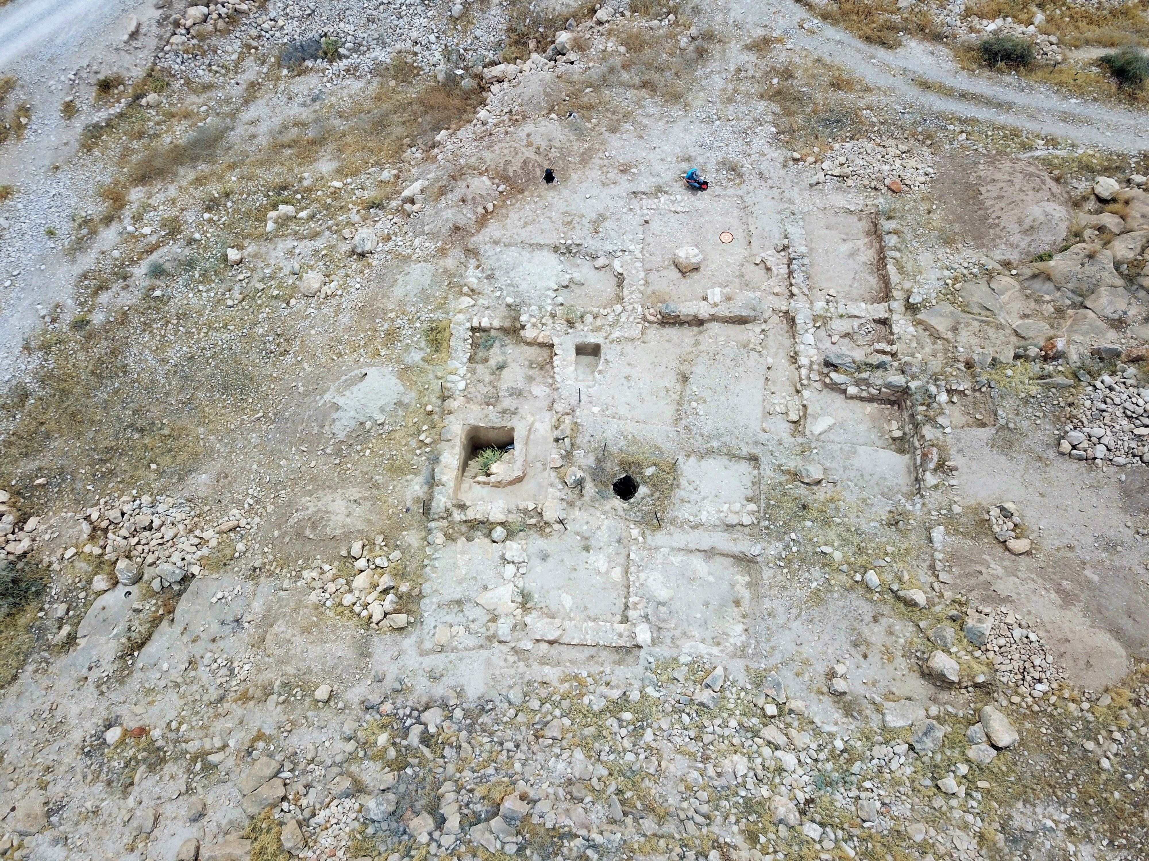
New excavations headed by Shay Bar in 2023-2025 found a Hasmonean period compound south of the Byzantine period tower. It was part of road station along the ascending route to the Hasmonean stronghold on Sartaba (Alexandrium).
The following aerial view focuses on the excavated courtyard on the south side of the tower. The courtyard covers an area of 15m x 12m, and has walls on all sides except for a partial wall on its west side. The archaeologist found remains of Hasmonean period walls and structures, including a cistern and reservoir, miqveh (ritual bath) and a structure used as a kitchen.
The major points of interest are further detailed below.
- Miqveh – Ritual bath
On the south east side of the Hasmonean period courtyard, adjacent to the cistern and the reservoir, is a small ritual bath (Miqveh). Its capacity is about 1.5 cubic meters. Its presence indicates that the station was built to accommodate Jewish travelers or garrisoned soldiers maintaining ritual purity on their way to the fortress.
Miqveh (plural: miqva’ot) installations, also known as ritual baths, are significant archaeological and cultural features in Israel, reflecting ancient Jewish practices of ritual purity. These installations have been found throughout Israel, dating from the Second Temple period (516 BC – 70 AD) and continuing through the Byzantine period.
The walls and 3 steps of the miqveh are plastered to ensure that they were watertight. Three layers of grey plaster indicates that the bath was in use for a long time, as it required to re-plaster from time to time.
Because Samaritan and Judean limestone is naturally porous and prone to fractures, unlined rock will swallow water rapidly. The Hasmoneans perfected a multi-layered, water-tight rendering system:
-
The rough-hewn bedrock walls were first smoothed down with a thick layer of coarse mortar mixed with ash, charcoal, and crushed pottery (which provided hydraulic properties, allowing the plaster to harden underwater).
-
This was finished with a fine, dense, gray plaster coating. This meticulous sealing ensured that water could sit stagnant for years without leaking into the mountain or ground.
On the bottom the archaeologists found a jug, cooking vessel and a Alexander Jannaeus coin, thus dating its use until the middle half of the 1st century BC. After then it was decommissioned by filling the installation with medium sized rocks.
- Reservoir:
On the north east side of the courtyard, adjacent to the cistern, is a deep pool carved directly into the rock. It received run off water via a hewn conduit that connected to the cistern. The walls and steps were covered with grey plaster, typical of the Hasmonean period, to ensure they were watertight.
Its total capacity is at least 10 cubic meters. A staircase leads to the bottom of the pool along its eastern and southern wall. The archaeologists dated the pottery inside the pool to the 1st century BC. It was then decommissioned by filling the pool with very large stones.
- Cistern
A square-shaped cistern, typical of the Hasmonean period, is located in the south side of the courtyard. It is 4.2m deep, its sides are 5m long, and the total capacity is 90 cubic meter. The cistern walls are covered with several layers of plaster.
The cistern stored flash flood waters collected from the surrounding slopes on the south western side. It had a rock hewn conduit that led runoff water to the reservoir.
- Kitchen
On the south west side of the Hasmonean courtyard are a number of rooms. One of them served as a kitchen, based on the in-situ finding of two tabuns (clay ovens), and a large grinding stone, that were used to prepare food.
The following photo is a view from the south. A collapsed wall on the west side of the kitchen brought a surprise to the excavators. A hoard of 165 bronze coins were found in and around the wall. All coins were of the same type – a common Alexander Jannaeus Pruta (“penny”) coin, dated to years 80-85 BC.
The coins were probably contained inside a leather bag that did not survive, and spread on the floor beneath the ruins of the kitchen wall. Prior to the abandonment or destruction of the site, the coins may have been tucked inside a crack in the wall, or left standing on a shelf.
(b) Late Byzantine period
During the Late Byzantine period (6th-7th century AD) a large rectangular structure was built as a fort on the north side of the Hasmonean complex. It was built over massive supporting walls, covering the center of the site and possibly covering sections of the Hasmonean site. Additional courtyards were built on the western and eastern sides of the tower.
- The Fort:
The rectangular structure, built in the Late Byzantine period, rises 6m above the hill it was built over. It has a trapezoidal shape and covers an area of 29m by 20m. The tower was built of large hewn stones.
The plan of the structure is a stepped tower platform. Instead of building straight vertical walls from the ground up, the engineers designed the tower base in three distinct, concentric tiers (or “stepped courses”). As the structure rose, each subsequent platform level stepped inward, meaning each higher course had a progressively smaller footprint and diameter than the one beneath it.
On the top of the fort, within an L shaped plan, are several rooms made of hewn stones.
An aerial view shows the plan of the rooms on top of the tower, with a view towards the west. The western section (top right corner) was damaged before the survey of 2001, cut by a bulldozer.
Here are some views of the rooms on top of the tower. This is the north west section:
The eastern side of the summit, with a view to the south:
A section on the south side, with a deep cavity under the floor:
From the top of the fort are great views of the valley of Tirzah (Wadi al-Far’a). Along this fertile valley was a major west bound route that ascended to Shechem and the heart of Samaria.
North of Rujm es Si’a is a new town that was established in year 2018 in an abandoned military camp (Gadi camp). This former Jordanian and IDF base was transformed by Shivat Zion into a permanent community of several dozen religious families, and a pre-military academy.
Courtyards:
On the west side of the fort is an irregular shaped courtyard. Its size is 70m by 70m. The courtyard is bounded by massive walls (2-2.5m wide). The courtyard was part of the Byzantine period settlement, and including various walls and an oval structure adjacent to its south wall.
The eastern courtyard covered an area of 25m by 25m. The survey team described that it had double walls (“casemate” like) on the south and northern area.
(c) South side
The site is located at the edge of the Juruzliya valley. This is where the ancient route led up to Alexandrium/Sartaba.
On the south side are several modern structures, belonging to the Sartaba farm (Mesu’a west) – an agriculture outpost established in 2023.
(d) Flight over the site:
The following views were captured on May 2026 over the site.
- Hasmonean excavations:
This view of the excavated area is towards the south.
- The Byzantine tower:
This is a view of the top of the tower, with a view towards the west.
(e) Video Tour
![]() Tour the site with this video (captured May 2026):
Tour the site with this video (captured May 2026):
Etymology – behind the name:
* Names of the site:
- Rujm es Si’a, Rujm es Saigh – name of the site
- The name may mean: “The Stone Heap of the Tax Collectors”. During the Hasmonean and Roman period it was a possible location for local authorities to collect duties, tolls, or taxes.
- Rujm – Arabic: heap, mound
- es-Si’a – Historically refers to the officials tasked with collecting the Zakat (mandatory charity/tax) or general state taxes, particularly in rural or nomadic regions.
- es-Saigh – The British map is written differently, changing the meaning to “The Goldsmith”.
- רוג’ם א-ציא – Hebrew name
- Wadi Kurzeleiyeh (or: Juruzliya) – adjacent valley, one of the routes ascending to Sartaba. Meaning: The valley of the Shepherds.
- ‘Ain el Kurzeleiyeh (or: Juruzliya) – spring (uphill, 1.5km west of the site). Meaning: The spring of the Shepherds.
- Mesu’a, Massu’a, Massua (משואה) – a community 0.5 km south east of the site, established 1969 as a Nahal settlement, then converted to a Moshav 5 years later . The name pays tribute to the historic beacons lit on the peaks of nearby Sartaba—a relay of torches that once signaled to distant communities that a new month had begun.
Links:
* External links and references:
- Rujm es-Si’a – Hasmonean road station on the route to Alexandrium (Sartaba) – Shay Bar, Michael Ozbond, Yoav Farchi – 9th conference of Jordan valley (May 2025), pp 7-20; Hebrew with English abstract
- “The Manasseh Hill Country survey”, Adam Zertal, Volume 4 site 86, pp. 292-295.
* BibleWalks sites:
- Sartaba – A Hasmonean and Herodian desert fortress on a high pointed mountain.
- Miqveh – ritual baths
BibleWalks.com – “Arise, walk through the land in the length of it and in the breadth of it…”
es Suwede Roman camp <<<—previous site—<<<All Sites>>>— next site—>>> Mt. Bezeq
This page was last updated on May 27, 2026 (total update)
Sponsored Links: