Remains of a vast structure complex dated to the Roman/Byzantine period.
Home > Sites > Sea of Galilee> Tiberias> Basilica
Contents:
Background
Location
History
Photos
* Aerial Views
* Video Tour
Links
Background:
In central Roman–Byzantine Tiberias, archaeologists uncovered the remains of a vast structure complex—over 2,000 square meters, with about 25 rooms.
Location:
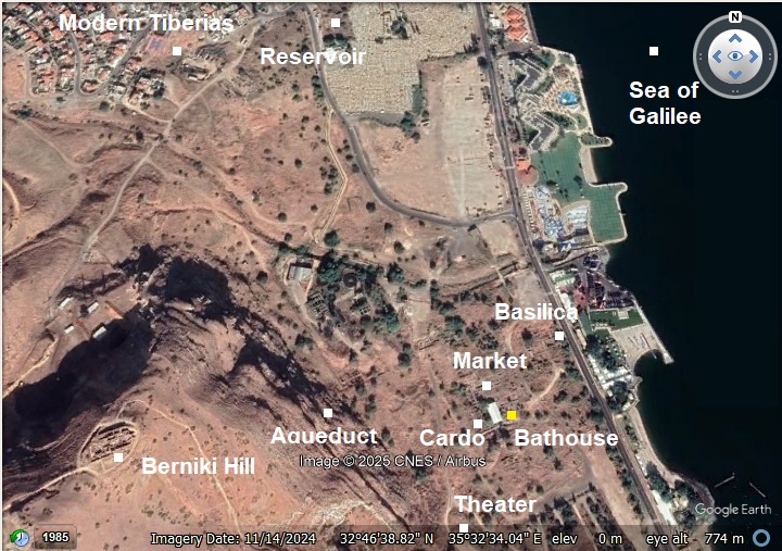
An aerial photo is shown below, indicating the major points of interest. The basilica is located in central Roman–Byzantine Tiberias, just 80 meters northeast of the bathhouse and close to the lake shore.
History:
Tiberias foundation:
Tiberias was founded in 18 AD by Herod Antipas, son of Herod the great and Jewish ruler of the Galilee (4 BC-39 AD). He was appointed by Augustus Caesar as the ruler of Galilee and Peraea, the east bank of Jordan. Herod Antipas made the new city his capital, and named the city after the Roman emperor, Tiberius Caesar.
-
Historical Phases of the Structure Complex
Renewed excavations (2008) have rewrote the history of the structure.
In central Roman–Byzantine Tiberias, just 80 meters northeast of the bathhouse and close to the lake shore, archaeologists uncovered the remains of a vast structure complex—over 2,000 square meters, with about 25 rooms.
It was first suggested to be a 2nd century Roman basilica, serving as the city’s judicial, civic, and commercial hub. It was also suggested that this may have been the seat of the Jewish Sanhedrin after its move to Tiberias around 220 AD. After new excavations, the archaeologists identify this structure as a 4th century urban mansion. It stayed in use into the Early Islamic era.
Phase 1 – Early Roman Period (1st century AD)
Construction of a Roman building during the establishment of Tiberias.
Phase 2 – Early Byzantine period (early 5th AD)
Construction of a large complex, over 2,000 m², divided into roughly 25 rooms. Built with well-dressed basalt and limestone blocks. Following renewed excavations, the structure was reclassified as a dwelling of one of the city’s notables.
Phase 3 – Late Byzantine Period (6th-7th century AD)
Several phases of renovation that took place.
Phase 4 – Early Islamic Period (7th–8th centuries AD)
Continued occupation with functional changes, including domestic use and small-scale industry. Some areas show signs of neglect and partial abandonment toward the end of this period.
A massive earthquake (749 AD) caused severe damages in the city, requiring several phases of renovation.
Phase 5 – Abandonment
By the later Early Islamic period, the complex fell out of use. Collapse debris and soil accumulation covered much of the site. The city was largely abandoned in the late 11th century.
Basilica Structure:
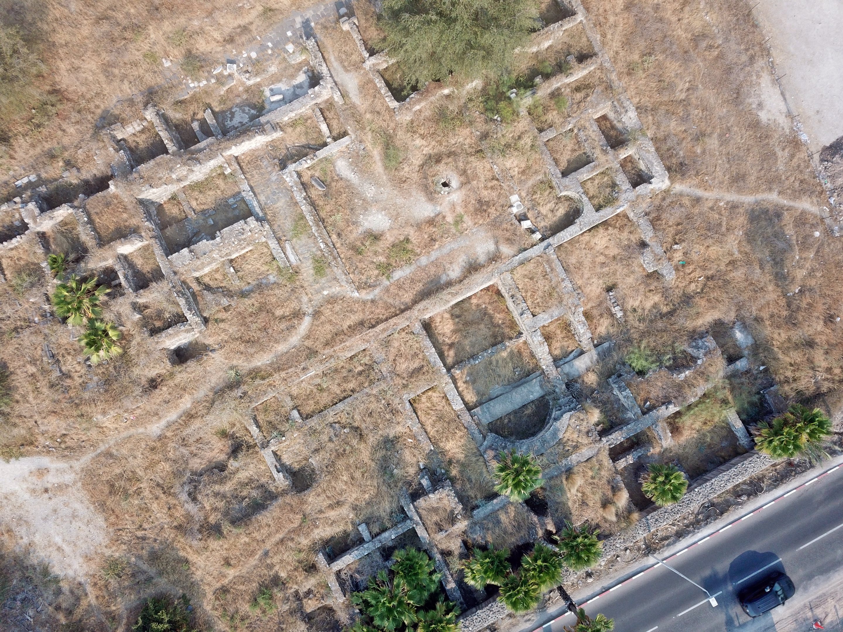
At the center of the mansion stood 3 apsidal halls, facing east north and south. These semi-circular architectural features are typical of Roman civic structures. On both sides of the apsidal halls on the north and south are square rooms, that were probably used for the landowner’s occupation.
The apsidal halls open to a peristyle courtyard – a continuous porch formed by a row of columns the surround. Under the peristyle courtyard, archaeologists uncovered a well-preserved arched cistern, evidence of careful planning for rainwater collection. It held 300 cubic meters of water.
Robust eastern walls remain at heights up to two meters, anchored along the promenade edge. Their width implies that sections of the building might have had had 2 floors. East of the Basilica was the promenade, which was open on the lake side. Route 90 passes along its path.
The private rooms of the residents were located along the western side, although this section was not yet excavated.
Beneath the basilica’s apse lies fragments of a 1st-century AD marble opus sectile floor, possibly originating from a Herodian-era palace built by Herod Antipas—consistent with Josephus’s descriptions. Associated fresco elements and luxurious marble support identification with a high-status residence.
The main entrance to the mansion was on the south wall, where a staircase led into the complex. This staircase, made of white limestone steps, led up from the south and east. A large drainage channel was found on the south side, probably under a paved east-west road, probably one of Tiberias cross streets.
Colonnaded Porch:
Approximately 100 meters south of the basilica in Roman-Byzantine Tiberias stood a large porch structure, likely part of the city’s formal urban architecture. It was 32m in diameter, 23m internal width. This colonnaded porch (or stoa) was aligned along the Eastern Cardo, forming an open yet roofed space used for public interaction, commerce, or ceremonial functions.
Photos:
(a) Aerial Views
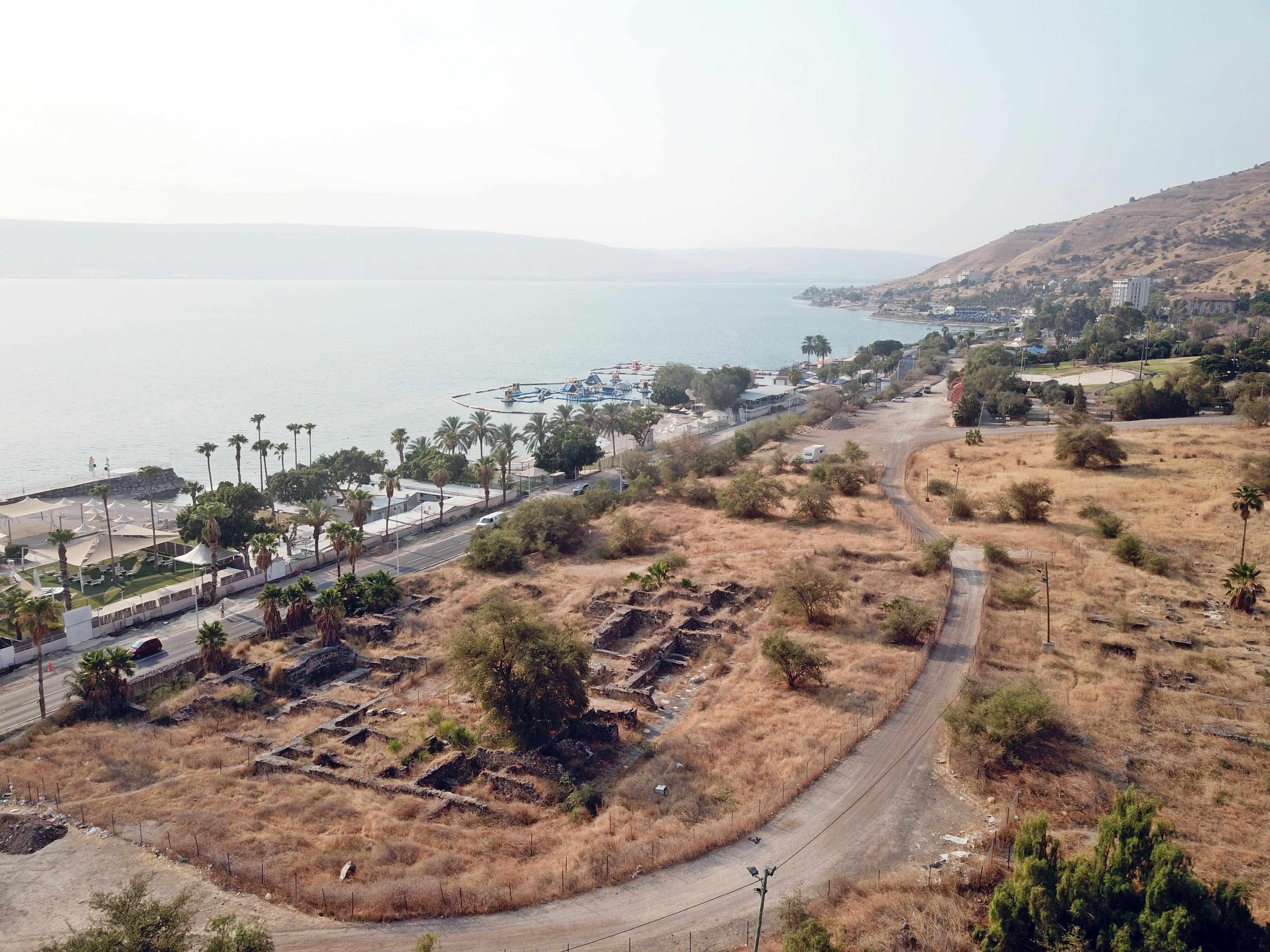
The following drone view towards the south shows a number of excavated sites in Roman/Byzantine Tiberias. The basilica is near the lake shore.
A view towards the south east is shown in the following photo. The ruins of the basilica complex are seen here along the highway.
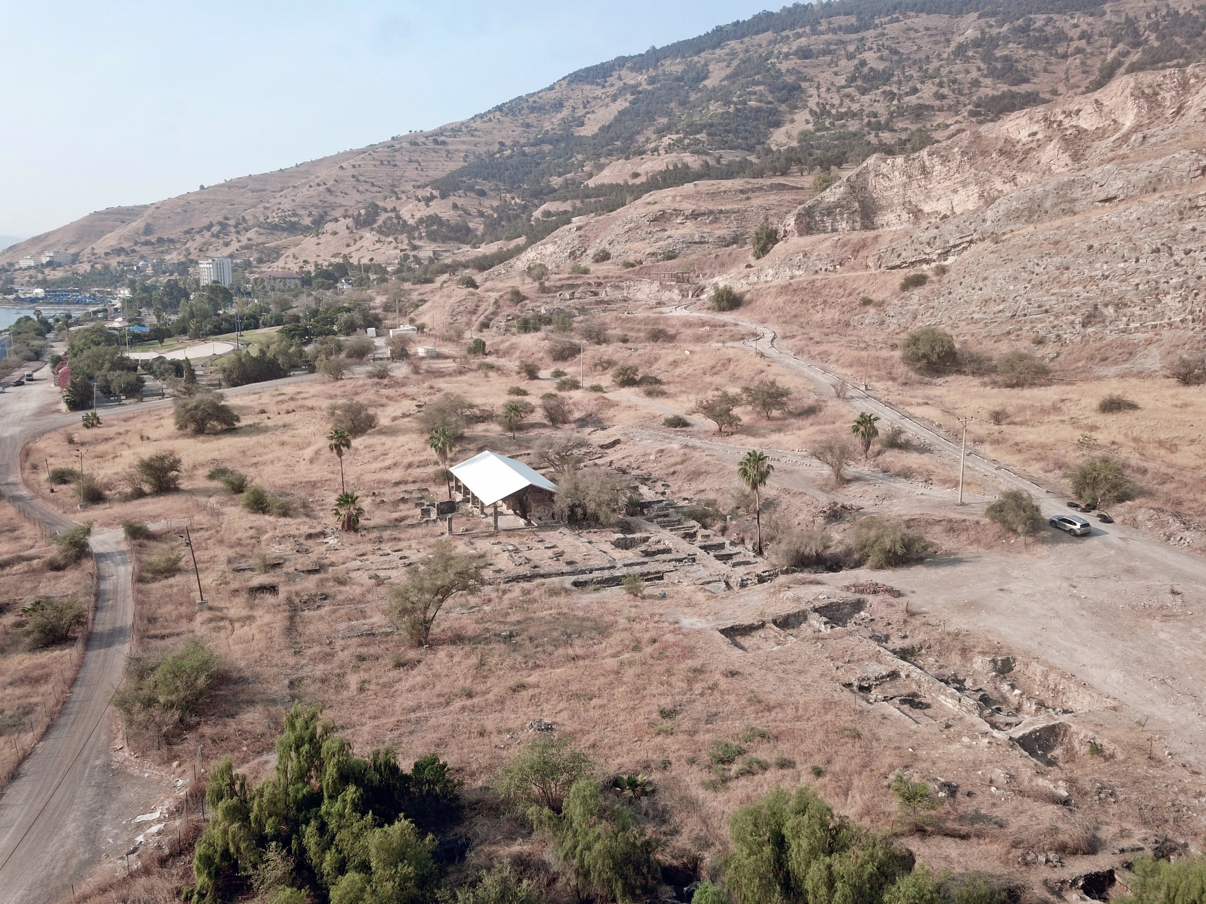
The following drone view, oriented toward the north, is a top view of the basilica. The modern coast road is seen at the bottom of the area.
(b) Video Tour
Visit the site with this 4 minutes video tour (visited June-July 2025).
Etymology:
- Basilica (Roman world) – A basilica was an ancient Roman public building, where courts were held, as well as serving other official and public functions. The word basilica is derived from a Greek term meaning “royal court”—from which the king exercised his reign.
- Basilica (Catholic world) – a basilica is a church building that has been recognized and accorded special privileges by the pope.
- Basilica plan (architecture) – refers to a rectangular building layout typically featuring a central nave flanked by side aisles, often with an apse at one or both ends. This plan was initially used for Roman public buildings like courthouses and markets, but later became widely adopted for Christian churches
- Stoae: plural of stoa – an ancient Greek covered walkway
Links:
* External:
-
Yizhar Hirschfeld, Excavations at Tiberias: 1989–1994, Israel Antiquities Authority (includes stratigraphy and architectural phasing).
-
B. Rabani, in Excavations at Tiberias: 1973–1974 – The Early Islamic Periods (gives background on reuse and transformation).
-
Tiberias and Hammat Tiberias, Berenice Channel – HAESI V130 2018
* Internal – Tiberias sites:
- Tiberias (overview)
- Tiberias South Gate
- Berniki Hill
- Bathhouse
- Basilica
- Miriam’s Well
- Hammat Tiberias
BibleWalks.com – enter the gates of the Holy Land
Theater <<<–previous site—<<< All Sites>>> —-next Sea of Galilee site –>>> Miriam’s Well
This page was last updated on Aug 14, 2025 (new aerial view)