The main city bathhouse of Roman Tiberias, adjacent to the Cardo Maximus and the market.
Home > Sites > Sea of Galilee> Tiberias> Bathhouse
Contents:
Background
Location
History
Photos
* Aerial Views
* Video Tour
Links
Background:
The bathhouse of Roman Tiberias, adjacent to the Cardo Maximus and the City Market. The bathhouse was identified as the main public bathhouse of Roman/Byzantine Tiberias, referenced in rabbinic literature. It functioned as a social hub, reinforcing communal ties across religious and ethnic lines in multi-cultural Tiberias. The structure underwent periodic architectural expansion and adaptation, reflecting changing usage patterns and urban development. It continued function until the 12th century, attesting to its enduring role even in Islamic-era Tiberias .
Location:
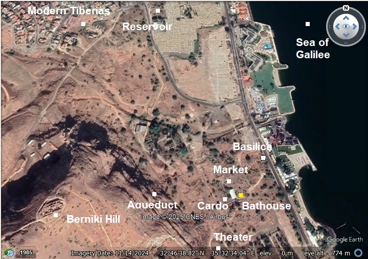
An aerial photo is shown below, indicating the major points of interest. The bathhouse is marked with a yellow square, in the center of the Roman city area south of the modern city of Tiberias. It is adjacent to the Cardo Maximus (west side of the bathhouse) and the city market (north side).
History:
Tiberias foundation:
Tiberias was founded in 18 AD by Herod Antipas, son of Herod the great and Jewish ruler of the Galilee (4 BC-39 AD). He was appointed by Augustus Caesar as the ruler of Galilee and Peraea, the east bank of Jordan. Herod Antipas made the new city his capital, and named the city after the Roman emperor, Tiberius Caesar.
Bathhouse history:
- Phase 1: Original Construction (4th century AD)
The public bathhouse in Tiberias was first constructed during the Late Roman period, around the 4th century AD.
Built adjacent to the Cardo Maximus, it included: A caldarium (hot room) with a hypocaust system; Mosaics in various rooms, often depicting animals like fish and birds; Use of hot spring water as a heating source—an innovation unique to Tiberias, replacing the traditional wood-burning furnaces of classical Roman baths.
- Phase 2: Byzantine Period Expansion or Renovation (5th–6th century AD)
During the Byzantine era, the bathhouse appears to have been renovated or expanded: Some rooms were repaved, and new mosaic floors may have been installed over older layers; There may have been architectural reconfiguration, possibly to adapt the building for new functions or more intensive use by a growing population.
- Phase 3: Early Islamic Adaptation (7th–8th centuries AD)
Under Umayyad and Abbasid rule, the bath continued in use, reflecting continuity of public life in the city: Heating and water systems were likely repaired or adapted; The decorative program may have been simplified or partially obscured (as Islamic norms evolved regarding figural imagery). Pottery and small finds from this phase attest to ongoing usage, including coins and lamps.
Phase 4: Later Islamic Periods – Fatimid to Crusader (9th–12th centuries AD)
The bathhouse was still functioning into the medieval period, possibly even the 12th century. Some rooms may have been abandoned or repurposed, while others continued to serve public or commercial functions. Evidence suggests partial collapses, blocked doorways, and informal reuse of rooms.
Phase 5: Decline and Abandonment
By the late Crusader or early Mamluk period, the bathhouse had largely fallen out of use. Over time it was buried under debris, reused for construction material, or forgotten beneath later urban layers.
- Modern period:
The bathhouse was excavated by Bezalel Ravani in 1955–56 on behalf of the Department of Antiquities.
Structure:
The complex covers approximately 1,300 m², showcasing its prominence as a civic building. It is 42m long (west-east) and 31m (north-south). The bathhouse was organized into two main wings:
- Eastern wing: Dressing rooms and social halls where patrons would gather—highlighting its function as both hygiene and community space.
Entrance to the bathhouse was on the eastern wing, leading to a long and narrow hall (5.8m x 19) on the north east side. The roof was supported on a number of basalt arches, and its floor was covered with colorful mosaics illustrating various animals (elephant, cheetah, donkeys, and more). Two doors on its southern wall led to 2 rooms: the large eastern room (12 x 9m) and a smaller western room (7 x 3.5m). Between them was a space, perhaps a pool.
Both rooms were decorated with a colorful mosaic floor. The floor of the western room included colorful geometric patterns, and medallions enclosing birds and fish. Under the floor the excavators found pottery of the 4th century.
3m under the floor of the western room was an underground pool, a unique feature of this bathhouse. Its basalt roof was supported by 24 short columns (1.4m high). The water came into the pool via an underground channel from the western wing, and the excess waters were conveyed thru the south east side. The water level was 1m above the floor.
- Western wing: Bathing rooms equipped with the traditional sequence of Roman style bathing facilities
This wing was the active bathing zone of the complex. It formed the western half of the bathhouse. On the western wing were a number of bathing rooms in different sizes, pools, water channels, ceramic pipes and rooms heated by hypocaust heating system. The warm rooms were in the center of the area between basalt columns that supported the roof. The west wing rooms and their functions:
Caldarium (Hot Room) – The largest and most architecturally sophisticated room in the western wing. Featured a raised floor on hypocaust pilae (small pillars) that allowed hot air to circulate beneath. (A hypocaust is an ancient Roman underfloor heating system that circulated hot air beneath a raised floor to warm rooms and baths). Walls possibly contained tubuli (clay flue tiles) to carry hot air up through the structure for wall heating.
Tepidarium (Warm transition Room) – Intermediate room between the cold and hot zones. Likely also equipped with a hypocaust system, though not as intense as the caldarium. Functioned as a transition room: warm, but not hot, allowing gradual body temperature change. May have featured warm basins, seating, or wall niches for oils and grooming items.
Frigidarium (Cold Room) Not clearly distinguished architecturally in the report, but inferred as part of the western suite. Likely the northernmost room in the western wing. Possibly featured a cold plunge pool, without hypocaust.
- Bathhouse Heating:
The bathhouse also used hot spring water as a heating source, conveyed from a nearby hot spring. Tiberias had a hybrid model:
-
Hot water from the spring piped or channeled into pools.
-
Hypocaust system used to warm the floors, walls, and air.
-
This setup saved on fuel and labor, while still delivering the full Roman bathing experience.
There is no surviving evidence of actual lead pipes or terracotta channels from the spring into the bathhouse in the published record (as of Stern 1992), but the geographic proximity and presence of hot pools are noted by both archaeological and historical sources.
Adjacent structures;
Cardo Maximus:
To the west of the bathhouse and marketplace in Tiberias ran the city’s main north–south thoroughfare, aligned parallel to the shoreline. This was the Cardo, a grand colonnaded street typical of Roman urban planning, designed to reflect the prestige of the city.
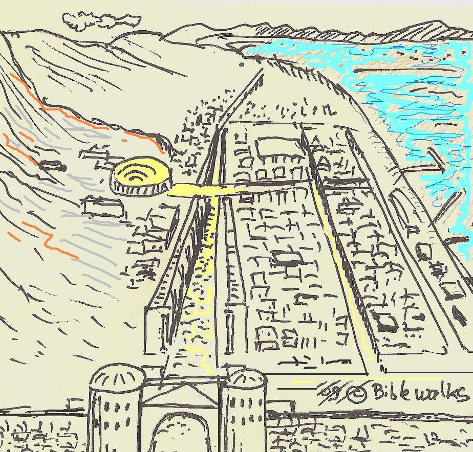
The following illustration shows the plan of the Roman/Byzatine city. The main city bathhouse was located adjacent to the main south-north colonnaded street, known as the Cardo Maximus (see sketch – highlighted in yellow).
The Cardo Maximus in Tiberias was constructed in the 2nd century AD and served as a monumental royal road. A significant section of it has been uncovered approximately 370 meters south of the bathhouse, near the southern gate of the city. This is an evidence of its function as a central spine through the urban grid.
The street itself measured 12 meters in width and was paved with diagonally set basalt stones. On both sides of the roadway were 5-meter-wide stoa —covered colonnaded walkways that offered shade and shelter. Behind these stoae stood rows of shops, each with a 1-meter-wide entrance and interior dimensions of approximately 3 by 3.6 meters. Excavations revealed six to seven such commercial units.
Taken together—the central roadway, stoae, and adjacent shops—the full width of the Cardo spanned an impressive 35 meters, underscoring the scale and significance of this Roman civic feature. Its design followed a common Roman plan of Cardo.
The Cardo Maximus of Tiberias was laid out according to the standard Roman urban planning model, featuring a broad, colonnaded north–south boulevard that served as the city’s central axis. This design mirrors the Cardo Maximus in Jerusalem, which also followed the Roman template of a main thoroughfare lined with porticoes and flanked by shops. Like in Jerusalem, the Tiberias Cardo played a vital role in both commerce and movement, connecting major public buildings and city gates, and forming the backbone of civic life during the Roman and Byzantine periods.
This layout closely parallels the Cardo Maximus in Jerusalem, also built during the Roman period (likely under Hadrian after 135 AD). The Jerusalem Cardo featured a similarly broad central road (about 11.5 meters wide), lined with granite and limestone columns that supported the covered walkways. Behind the porticoes were rows of uniform shops, typically about 3 x 3 meters in size, which is strikingly close to the Tiberias shops (measuring 3.0 x 3.6 meters) with standardized 1-meter-wide entrances. Both cardines served not only as commercial hubs but also as the main arteries of movement, connecting city gates, markets, basilicas, and bathhouses.
In short, the Cardo Maximus of Tiberias exemplifies the Roman imperial vision of urbanism, just like the Jerusalem Cardo: wide, orderly, colonnaded, and integrated into a broader civic and commercial infrastructure. These similarities reflect not only shared architectural standards across the empire, but also the Roman effort to impose a visual and functional order onto their provincial cities.
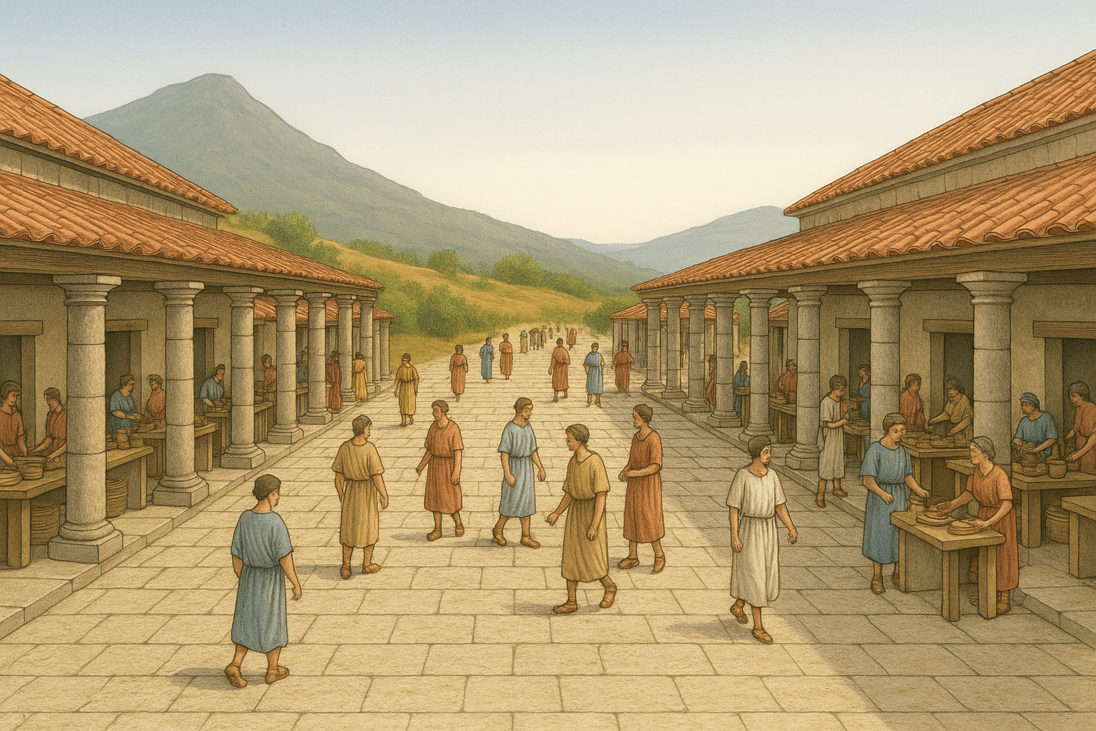
A Figurative colonnaded Roman street – AI generated by ChatGPT
Eastern Cardo:
In addition to the main Cardo Maximus west of the bathhouse, a secondary colonnaded street ran north-south between the market and the basilica, forming the eastern cardo of Tiberias. The road was constructed in the 2nd–3rd centuries AD, forming part of Tiberias’ structured Roman urban grid alongside the Cardo Maximus and public buildings such as the basilica and bathhouse. Its usage continued through the Byzantine and Umayyad periods, until it was partially destroyed in the 749 AD earthquake.
City Market:
Directly north of the bathhouse and adjacent to the west-facing Cardo Maximus, archaeologists have uncovered a row of shops and a colonnaded street segment, interpreted as part of the city’s principal market area. This commercial zone comprised simple shop units, each accessible only through a door (no windows), and arranged along the street façade. Behind the shops, column bases indicate the presence of a covered stoa or portico, which likely functioned as a protected marketplace. The total footprint of the market measured approximately 800 square meters, indicating a sizable commercial space designed for dense urban use.
This substantial public market complex, distinguished by three parallel rows of column bases, each row comprising seven bases. These bases were constructed from local basalt and limestone—some of them intriguingly repurposed from earlier architectural elements, including carved stone doorframes taken from ancient tombs. This practice of reuse (spolia) was not uncommon in Roman and later construction, reflecting both practicality and symbolic layering of history.
At the eastern end of each row, excavators documented massive square piers, each measuring 2.2 by 2.2 meters, which likely supported a series of arches that spanned a covered portico or connected to the adjacent street colonnade. These large piers may have functioned as visual and structural anchors, marking the transition between the internal market and the outer street. There are 4 piers on the eastern edge of the market area, and 4 more piers on the eastern side of the street.
The market was clearly bounded: a 2.6-meter-thick wall defined its northern edge, while the Cardo Maximus—the city’s main colonnaded street—framed it to the west, offering both high visibility and ease of access. This strategic placement allowed for a direct connection between public bathing, commerce, and urban traffic flow, consistent with Roman city planning principles where markets were often integrated into civic cores.
The design reflects a thoughtful combination of functional grid layout and monumental architecture, with clear movement corridors and structural symmetry. The covered colonnades would have offered protection from sun and rain, enabling year-round market activity. The reuse of funerary stone hints at cultural transitions or shifts in land use priorities, and underscores the complex stratigraphy of Roman Tiberias.
Excavators proposed that the section north of the bathhouse formed a continuous covered market, bisected by the Cardo itself—a marketplace overlaid by the main thoroughfare—similar in layout to Roman arcaded markets. One distinct paved stretch, termed “Galilee Street,” lies on the western side of the basilica complex and includes around 50 meters of basalt pavement flanked by shops. This suggests the urban planning integrated the Cardo, marketplace, and public basilica into a cohesive civic quarter. Material culture recovered from this area—including coins, oil lamps, glass vessels, stone and metal goods—reinforces the role of this zone as a bustling retail and civic center during the Roman to Byzantine periods (2nd–5th centuries AD).
Basilica:
Excavations revealed a monumental basilica, spanning over 2,000 m² and comprising around 25 rooms. It is situated 80m north east of the bathhouse. To its west, it bordered the Eastern Cardo, a roofed colonnaded street, likely functioning as a covered public walkway. To its east, the basilica opened onto a beachside promenade, adjacent to the shoreline of the Sea of Galilee.
The basilica complex was originally constructed in the 2nd century AD, likely during the height of Roman urban development in Tiberias. The structure served as a Judicial, civic and commercial hub. Scholars suggested that it served as the seat of the Jewish Sanhedrin, relocated to Tiberias around 220 AD soon after the death of Rabbi Judah ha-Nasi, but there are other candidate sites.
It underwent significant reconstruction and expansion during the Byzantine period (5th–7th centuries AD), reflecting changes in architectural style and civic function. The site continued to be in use through the Early Islamic period, indicating a prolonged legacy of administrative or communal activity.
The basilica consists of the following principal elements endured in its core phase:
-
A colonnaded open-air courtyard or gathering space for public interaction. Beneath, archaeologists discovered a vaulted cistern, indicating rainwater collection and advanced planning for water storage
-
A covered passageway or portico that framed the courtyard.
-
On the western side of the courtyard, a large reception hall with a semicircular apse, where civic or judicial assemblies occurred.
- Flanking the courtyard are smaller rooms—perhaps administrative offices, classrooms, or support spaces—such that the entire layout exhibits symmetrical axial planning with functional zoning
The basilica occupied a large square footprint measuring approximately 38 by 38 meters, forming a substantial civic complex at the heart of Roman-Byzantine Tiberias. At the center of the basilica stood an impressive apsidal hall, a semi-circular architectural feature typical of Roman civic structures used for official gatherings. The hall was 14.5 m long and 12m wide, flanked by rows of columns, forming a colonnaded space that emphasized its architectural and functional significance. The apse, located at the eastern end of the hall, likely served as the focal point for official proceedings—perhaps housing a magistrate’s seat, tribunal, or administrative podium. The columns surrounding the central hall created a sense of grandeur and order, marking out aisled divisions and possibly supporting a vaulted or timbered roof. The layout would have directed attention toward the apse, reinforcing the authority and ceremonial function of the space.
Under the courtyard, archaeologists uncovered a well-preserved arched cistern, evidencing careful planning for rainwater collection. Robust eastern walls remain at heights up to two meters, anchored along the promenade edge. Beneath the basilica’s apse lies fragments of a 1st-century AD marble opus sectile floor, possibly originating from a Herodian-era palace built by Herod Antipas—consistent with Josephus’s descriptions. Associated fresco elements and luxurious marble support identification with a high-status residence.
The apsidal hall was not only an architectural centerpiece, but also a symbolic core of civic power—hosting legal hearings, commercial agreements, and public announcements. Its design closely mirrors those found in other Roman provincial cities, such as the basilicas at Scythopolis or Caesarea, and aligns with the classical basilica form later adopted in early Christian church architecture. The design followed a typical Roman civic basilica layout: a large rectangular space with aisles separated by colonnades, terminating in an apse. Such structures were commonly used for legal proceedings, public announcements, city council meetings, and market-related administration.
The secular character is further emphasized by its strategic urban placement—between the Eastern Cardo and the shoreline promenade—suggesting it was a key hub of public life in Tiberias. Unlike later religious basilicas, no evidence of a liturgical function (such as an altar or church fittings) was identified in this hall. This classical basilica form was later adopted in early Christian church architecture.
During the Byzantine period (5th–7th centuries AD), the building underwent a significant transformation: it was converted into a Christian church. This adaptation was part of a broader trend throughout the Byzantine Empire, in which Roman civic buildings were reconfigured for religious use as Christianity became the dominant faith. In the Tiberias basilica, this likely involved architectural modifications—such as the addition of an altar in the apse, liturgical furnishings, and perhaps a baptistery—while maintaining the core basilical layout of a central nave flanked by side aisles and ending in an apse. The basilica complex was extended to the east, its hall was enlarged to 21m long and 15m wide, and its floor was paved with mosaics. The transition reflects both the continuity and transformation of urban space in Late Antiquity. A structure once central to public and civic life became a center for religious worship, symbolizing the changing ideological and cultural landscape of the city. With the Byzantine period extension, the basilica encroached upon the open space of the promenade, likely narrowing the promenade or integrating it partially into the ecclesiastical complex.
Approximately 100 meters south of the basilica in Roman-Byzantine Tiberias stood a large porch structure, likely part of the city’s formal urban architecture. It was 32m in diameter, 23m internal width. This colonnaded porch (or stoa) was aligned along the Eastern Cardo, forming an open yet roofed space used for public interaction, commerce, or ceremonial functions.
Photos:
(a) Aerial Views
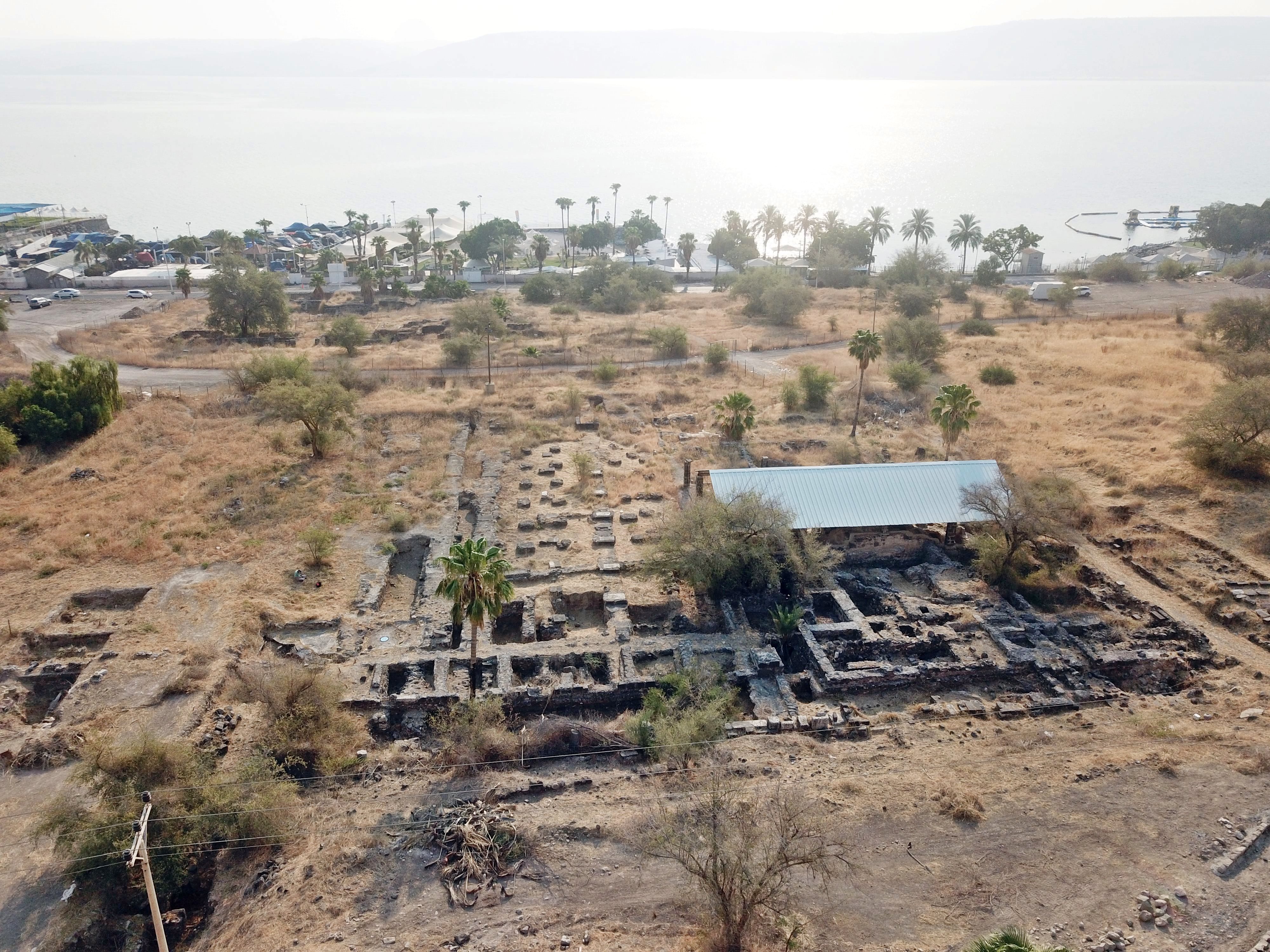
The following drone view towards the south shows a number of excavated sites in Roman/Byzantine Tiberias. The bathhouse is adjacent to the Cardo Maximus and to the city market.
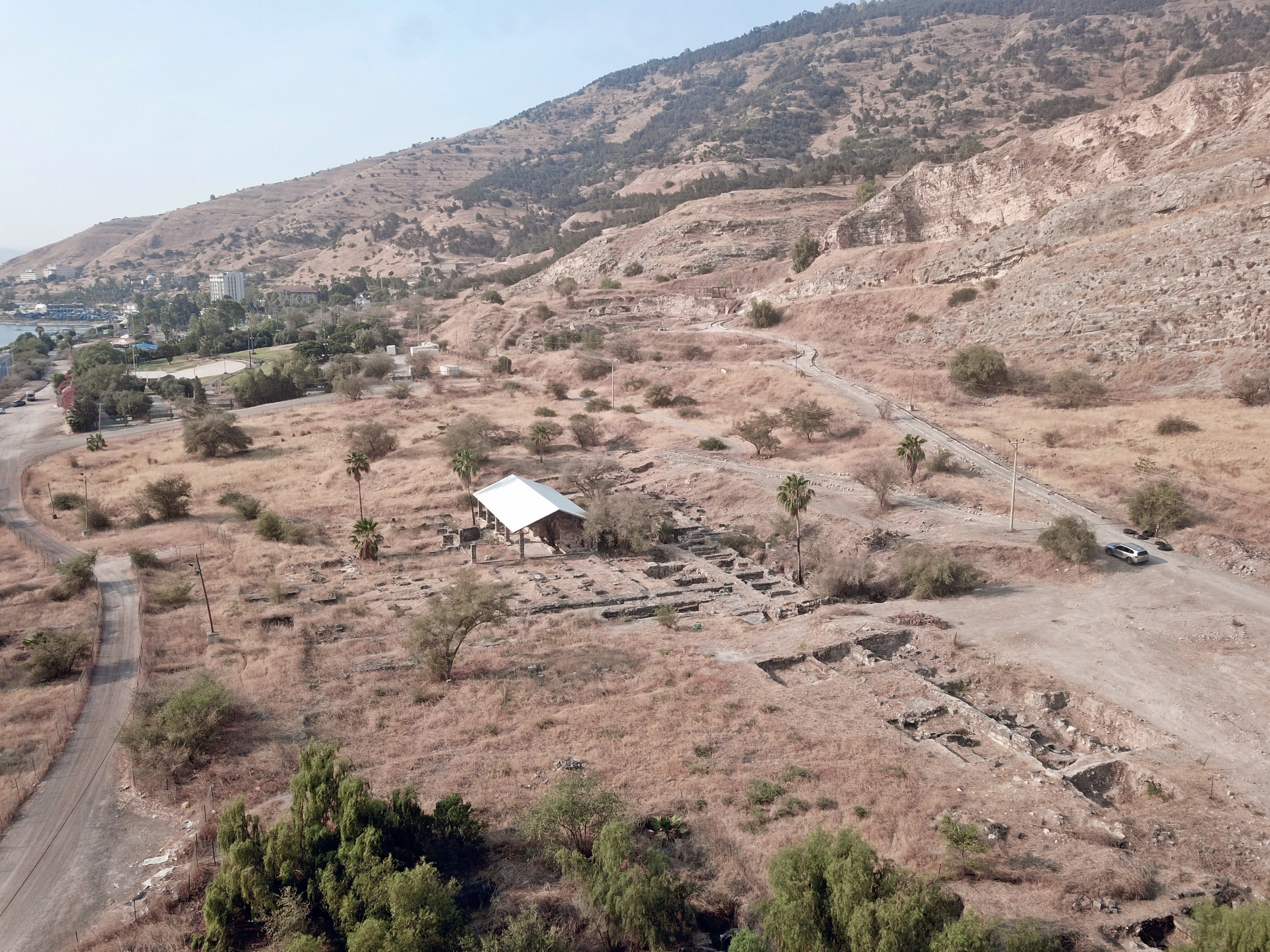
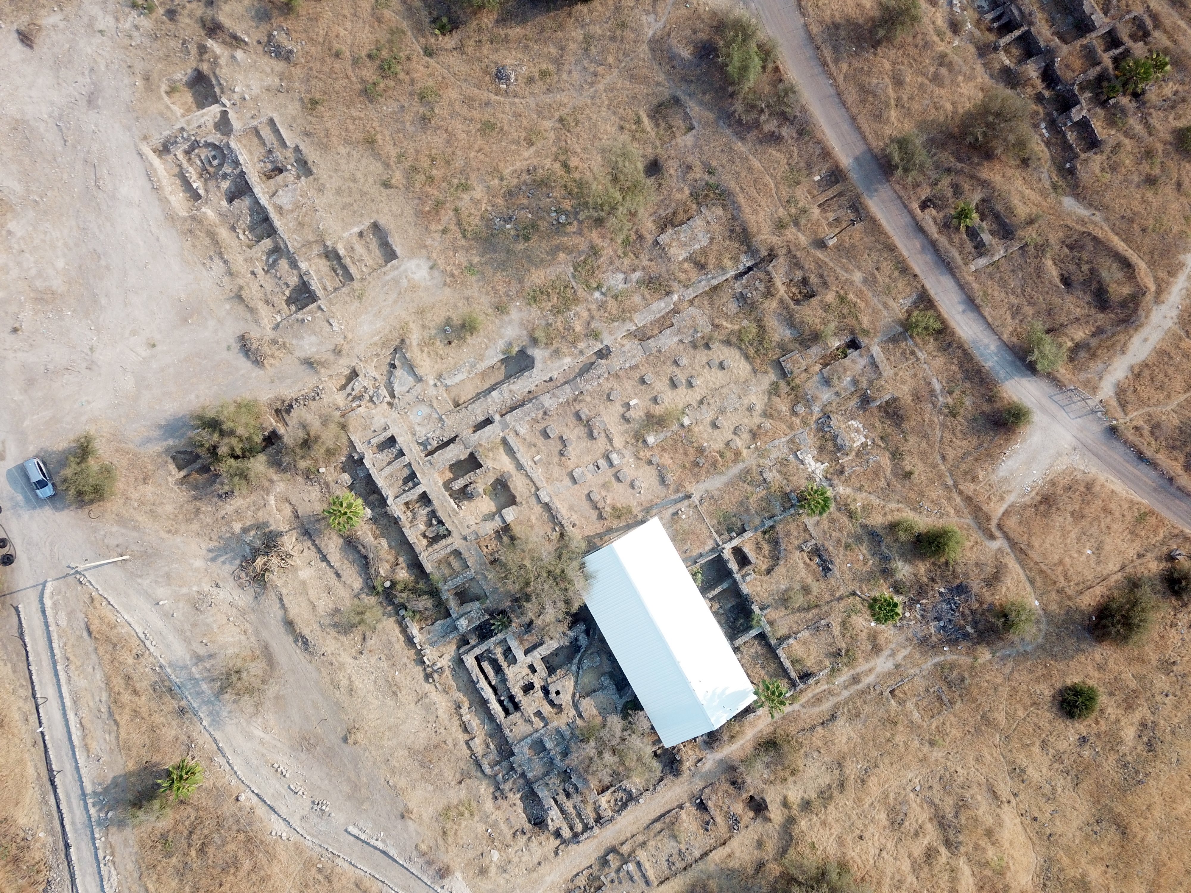
The next drone view, oriented towards the north and focusing on the bathhouse , shows the plan of the area around the bathhouse. Its eastern wing, with the mosaic floors, is under the white canopy roof. The western wing is to the left, adjacent to the Cardo Maximus. North of the bathhouse are the ruins of the city market.
Another view towards the Sea of Galilee is seen below. The Cardo Maximus passed along the western wing of the bathhouse, and the market is on the north (left) side.
(b) Video Tour
Visit the site with this 6.5 minutes video tour (visited June-July 2025).
Etymology:
- Stoae: plural of stoa – an ancient Greek covered walkway
Links:
* External:
-
Yizhar Hirschfeld, Excavations at Tiberias: 1989–1994, Israel Antiquities Authority (includes stratigraphy and architectural phasing).
-
B. Rabani, in Excavations at Tiberias: 1973–1974 – The Early Islamic Periods (gives background on reuse and transformation).
* Tiberias BibleWalks sites:
BibleWalks.com – enter the gates of the Holy Land
Theater <<<–previous site—<<< All Sites>>> —-next Sea of Galilee site –>>> Berniki Hill
This page was last updated on Aug 10, 2025 (add photo)
Sponsored links: