The best preserved Roman camp, located on the eastern fringes of Samaria.
Home > Sites > Samaria > Khirbet es-Suwede (Roman camp)
Contents:
Overview
Aerial Map
History
Plan of camp
Photos
* Aerial Views
* Tower
* The Camp
* Extensions
* Water Works
* Necropolis
* Ceramics
* Roman Road
* Flight Over
Etymology
Links
Overview:
The Roman camp at es-Suwede is a significant but relatively lesser-known archaeological site located on the eastern fringes of the Samaria highlands, overlooking the Jordan Valley.
It is particularly notable because it is one of the few examples of a large, permanent Roman military camp in the region, as opposed to the more common temporary siege camps found elsewhere in Israel.
Map / Aerial View:
An aerial map is shown here, indicating the major points of interest around the site. The ruins of the camp area spread over 40 dunams (4 Hectares). A Roman road passed near the camp on the ridge above Wadi Shaib.
History:
- Biblical periods
An ancient settlement existed on this location prior to the Roman camp. This is based on the survey’s ceramics dating, with 15% of the pottery collected around the site was dated to the Bronze/Iron and Hellenistic ages.
The cities and roads during the ancient periods up to the Roman period, are indicated on the Biblical Map below. The site is indicated as a red square. Its location is close to the Jordan valley, to the North-South route, and to the Jordan river crossings. An ancient east-west route passed on the north side, ascending to heart of Samaria and the city of Shechem.
Map of the area – during the Bronze/Iron ages to Roman periods (based on Bible Mapper 3.0)
- Roman period
The site was primarily active during the Early and Late Roman periods (1st–4th centuries AD), with evidence of continued use into the Byzantine era.
The camp likely originated around the time of the First Jewish-Roman War or shortly after. The Romans needed a permanent presence to prevent local insurgents from using the desert wadis as hideouts and to protect the road from Neapolis (Nablus) to the Jordan Valley.
The Romans didn’t just occupy the cities; they meticulously mapped and fortified the “edges” of their provinces. By placing a major camp at es-Suwede, they ensured that no one could move from the desert into the heart of Samaria without being seen by a Roman sentry.
During the 2nd and 3rd centuries, the camp functioned as a police and customs hub. It oversaw the “annona” (grain tax) being transported from the fertile Jordan Valley up into the central hills.
Illustration of a Roman camp – AI generated Credit: Gemini AI / BibleWalks Collection
- Byzantine period
While the military character of the site eventually faded, the infrastructure remained. In the Byzantine period, the site likely transitioned into a civilian or monastic settlement, utilizing the Roman-engineered water systems for agriculture. Some of the rooms in the camp were dismantled and their stones were reused for reconstruction, create farming courtyards, and block streets.
- Ottoman Period – (1516-1918 A.D.)
Conder and Kitchener of the Palestine Exploration Fund (PEF) surveyed the area during the Survey of Western Palestine (SWP) in 1874-75. This is a section of their map, focusing on the site. Notice the double dashed lines crossing at the vicinity of the camp – indicating major Roman roads. The road passing near the camp connected the Jordan valley to the heart of Samaria, while the north-south road on the right side of this section of the map connected Beit Shean to Jericho.
The surveyors merely stated (Volume 2, Sheet XII, p. 240): Khürbet es Suweideh (O n).—A ruined village with a rock cut tomb and sarcophagus, and a large watch-tower of solid masonry”.
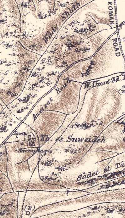
Part of map sheets 12 of Survey of Western Palestine,
by Conder and Kitchener, 1872-1877. (Published 1880, reprinted by LifeintheHolyLand.com)
- British Mandate
A 1940s British map shows the area around the site (enclosed in dotted area in the center of this section of the map, named Kh. es Suweida). To the west and north is Wadi esh Shayib, and to the south and east is Wadi el Firan. No sites are seen in the desert area around the camp.
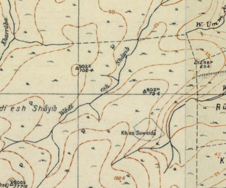
British survey map 1942-1948 – https://palopenmaps.org topo maps
License: public domain under the UK Copyright, Designs and Patent Act 1998
- Modern period survey
Adam Zertal thoroughly surveyed the site (in years 1993 thru 1996), and added valuable information in volume 2 of the The Manasseh hill country survey. This massive archaeological undertaking led by the late Adam Zertal (University of Haifa). Zertal’s work transformed our understanding of the eastern Samarian desert fringes, moving it from a perceived “wasteland” to a strategically managed imperial frontier.
Zertal and his team (notably Shay Bar in later volumes) documented the site in detail, primarily in Volume II (The Eastern Valleys and the Fringes of the Desert, pp. 530-535) of the survey series. Zertal identified es-Suwede as a critical link in a chain of Roman military sites. He argued that the camp was not just an isolated outpost but part of a coordinated defensive and administrative line designed to monitor the desert transition zones. Zertal highlighted that the camp was built at a precise ecological boundary. It sits where the Mediterranean climate of the Samarian hills meets the semi-arid Jordan Valley, allowing the Roman military to control the movement of nomadic groups and secure the “Ma’ale Ephraim” pass.
The survey noted the unusual preservation of the site. Because it was never built over by a modern city, it was possible to map a classic Roman castrum layout, including the principia (headquarters) and organized barracks, which is rare for this region.
Zertal placed heavy emphasis on the large dam and pool at the site. His survey concluded that the Roman engineers specifically chose this “inhospitable” spot because they could harness seasonal runoff, turning a dry wadi into a permanent water source for a full garrison.
Plan of es Suwede camp
Surveys of the Roman camp at es Suwede have revealed a highly organized military layout:
-
The camp features a large rectangular enclosure (188m x 100m) containing a network of rooms and internal streets, typical of Roman castra (fortified camps). It was initially protected by a 1.3m wide wall, and was divided in quarters by longitude and latitude intersecting streets. Ruins of a tower is standing on the south side overlooking the rea.
-
One of the site’s most impressive features is its sophisticated water system, which includes a dam and a large pool (reservoir) to sustain a permanent garrison in the arid eastern Samarian climate.
-
Archaeological surveys have identified structures extending outside the main walls, suggesting a civilian settlement or vici (auxiliary village) may have developed around the military presence.
-
Positioned on the edge of the desert, the camp likely served as a key administrative and defensive hub for controlling the routes between the central Samarian hills (near Neapolis/Nablus) and the Jordan Rift Valley.
An AI generated illustration shows a figurative view of the camp.
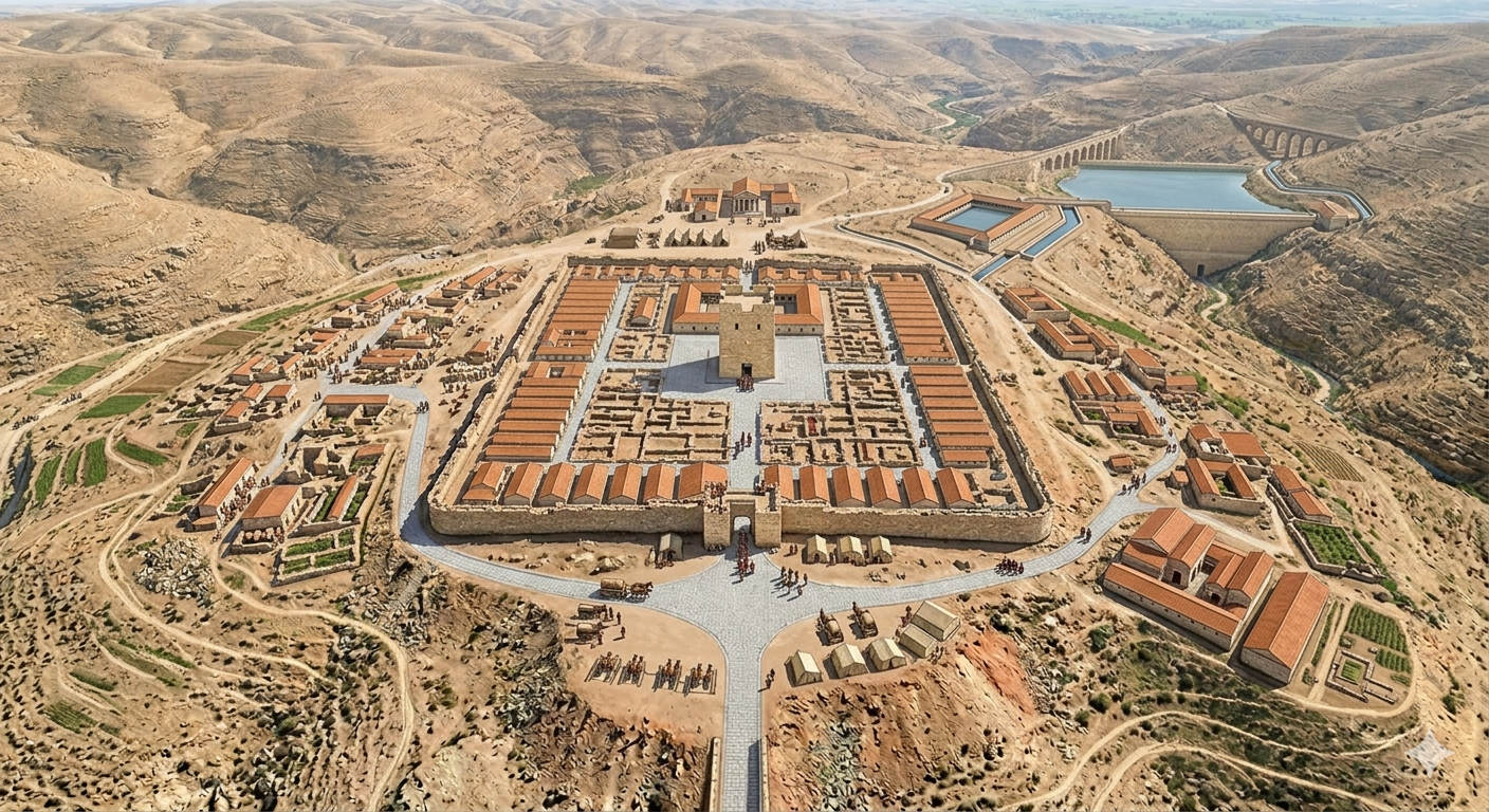
Proposed reconstruction of es-Suwede Roman camp – AI generated Credit: Gemini AI / BibleWalks Collection
Photos:
The photos and videos were captured on Jan 2023.
(a) Aerial Views
The following view is towards the north east. This vast camp was built over a ridge that descends into a lower valley.
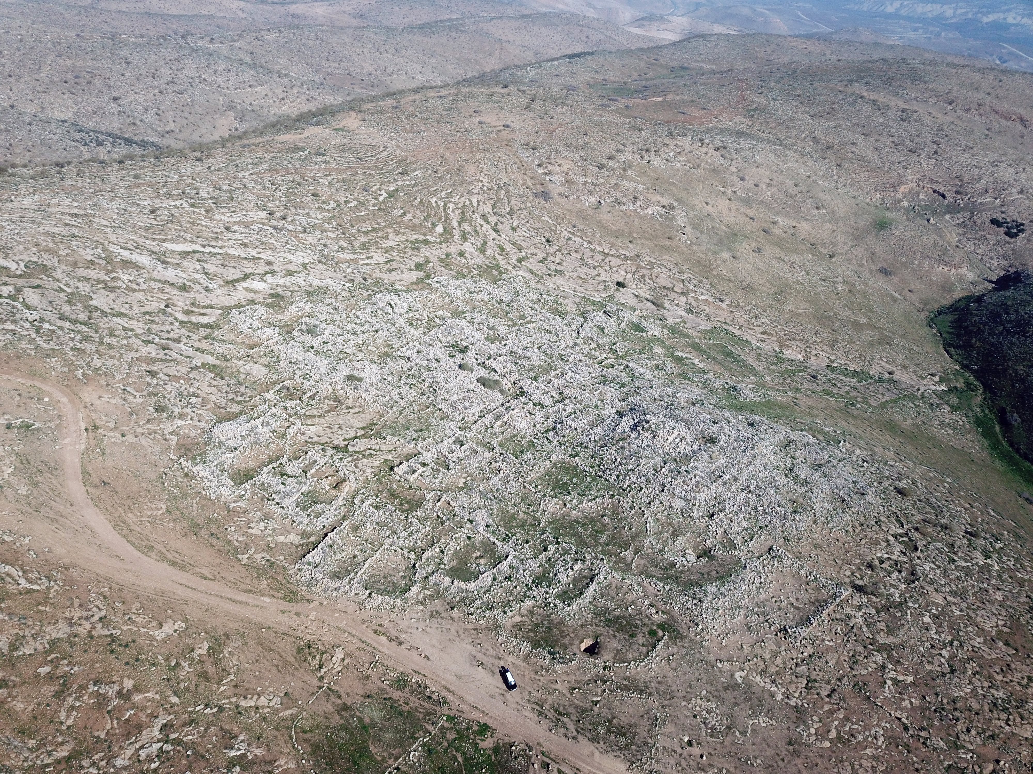
The major points of interest are illustrated on this view. The central enclosure is arranged as a large rectangular, measuring 188m long and 100m wide. The camp was constructed with its primary length oriented north-to-south to follow the natural contour of the ridge it sits upon.
The camp is densely built with dozens of small rooms. Longitude and Latitude streets allow movement within the enclosed area.
A tower stands high in the center of the southern section. Outside the central enclosure are extension structures on the east and west sides.
To the north is a Roman road that connected the the Jordan valley to Samaria. A large water reservoir was in the valley on the south east side.
A closer view of the southern section of the camp is shown below. This view is towards the east, and in the far background is the Jordan valley and the Jordanian mountains behind.
The tower, seen here at the top of the hill, stands high above the camp and has a great view of the surroundings.
The space was divided by a network of intersecting streets: Longitude streets (along the longer north-south axis, each 3m wide) and Latitude streets (along the east-west axis, each 4m wide). This layout created multiple blocks , that encompassed rooms, courtyards and alleys.
The following aerial view is oriented to the south:
Yet another view towards the north:
(b) Tower
A high tower rises over the southern part of the enclosed area.
The area of the tower is 10m x 10m. It is built with very large stones with drafted margins.
An aerial view of the central tower is shown below, as seen from the north side.
From the tower are great views of the camp, such as this northern view below. North of the tower is a long hall.
On the northern side of the camp were two smaller towers.
(c) The Camp
In his Manasseh Hill Country Survey, Adam Zertal identified a total of 85 rooms within the rectangular enclosure of the Roman camp at es-Suwede. The average size of the rooms was 4m x 4m. The rooms in the southern section had 2 floors, as judges by the amount of fallen stones.
This is a view from the north, viewing the area north of the tower:
These rooms were organized into several distinct functional areas that reflect the highly structured nature of a Roman military garrison:
-
The Barracks (Contubernia): The majority of the 85 identified rooms belonged to the soldiers’ living quarters. These were arranged in long, linear blocks along the inner perimeter and the internal streets.
-
The Headquarters (Principia): A cluster of rooms at the center of the camp served as the administrative core, including the commander’s office and a small inner courtyard.
-
Commanding Officer’s Residence (Praetorium): Larger, more distinct rooms were identified as likely belonging to the residence of the unit’s commander.
-
Storage and Workshops: Additional rooms located near the gates were identified as granaries (horrea), stables, and maintenance workshops for military equipment.
The rooms were not scattered but were arranged in regular rows bordering internal streets. This layout is typical of a castrum, where efficiency of movement and clear hierarchy were prioritized.
The layout within the rectangular area featured a repeating grid of 4×4 room clusters. This is a hallmark of the Centuriation (or limitatio) planning system applied to military architecture. This is called a “Quadruple contubernium”, a common Roman military plan.
Here is an example of intersecting streets (marked in yellow), with a 4×4 grid of rooms built between them. A 4×4 grid of rooms allowed for the housing of two full centuries (with their respective front and back rooms) in a single, compact square block. Each room is 4x4m in area, and so the area of the grid is 16 x 16m. A Roman century (roughly 80 men) was divided into ten contubernia (groups of 8). A 4×4 grid of rooms allowed for the housing of two full centuries (with their respective front and back rooms) in a single, compact square block.
In this 16-room (4×4) configuration, the layout usually followed a strict hierarchy:
-
Inner Rooms: Often used for sleeping quarters (the papilio).
-
Outer Rooms: Used for the arma (storage of shields, heavy gear, and sometimes pack animals).
-
The Grid Lines: The paths between these 4×4 blocks were kept precisely clear to allow for the “Alarm Response”—ensuring that hundreds of men could exit their rooms and reach out of the camp simultaneously without creating a bottleneck.
The following are some views inside the camp:
Some of the door entrance standing jambs are seen standing in across the camp.
Another example of door jambs is below.
Bolt-holes cut directly into the gate-stones held the locking beams in place.
The walls were constructed using large, roughly hewn blocks of local limestone. The thickness of these walls suggests they were intended to withstand significant pressure or prolonged isolation.
Some of the stones have drafted margins, and a rough boss in the middle with carved lines.
(d) Camp Extensions
Extensions to the rectangular area of the camp were built on the western and eastern sides. They were probably built in another phase of construction when the camp had to grow in size. These external buildings may also suggest a civilian settlement or vici (auxiliary village) that may have developed around the military presence.
On the Western side about 10 dunams of rooms were added. On the eastern side, viewed below, the area was also populated with courtyards and rooms.
Another view (northwards) of the extended area below the eastern side:
(e) Water Works
The area of Es Suweide sits in a transitional climatic zone. Because it lies on the eastern leeward side of the mountain range, it experiences a “rain shadow” effect, where precipitation drops off significantly compared to the western slopes. As clouds move from the Mediterranean across the Samarian highlands, they lose most of their moisture on the western side. By the time they reach the eastern slopes heading toward the Jordan Valley, the air descends and warms, leading to much drier conditions. The annual average rainfall for this specific part of Eastern Samaria typically ranges between 200 mm and 300 mm (roughly 8 to 12 inches). Like most semi-arid regions, the actual amount can vary wildly from year to year. A “wet” year might see over 400 mm, while a drought year could result in less than 150 mm.
The closest spring to the site was in Ein Hilu (Ein-Helweh, Arabic for “sweet”) is 5 km north. In this dry area, the engineers needed to find a good supply of water for the camp within the reach of the soldiers.
One solution was to build reservoirs. Fifty cisterns were built under the buildings to store the run off rain water for the supply of water. Here is one of them:
However, use of cisterns was not sufficient for the supply of water for this large camp, and so the engineers added a large pool outside the area of the camp. Its location is seen here in the green area at the top of this view towards the south east.
The pool was located in the bottom of the valley of Firan, 200m east of the camp and about 50m lower than the camp. It collected run off rain water that accumulated in the valley above the pool during the few rain days. Nearly all precipitation occurs between October and May, with the heaviest rainfall typically concentrated in December, January, and February.
The pool was created by building a dam across the valley. The dam was 15m long and 2m wide.
The size of the rectangular pool was 20m x 26m, with 1m wide walls. It could store more than 1000 cubic meter of water.
A path led from the pool, at the bottom of the valley, up to the camp.
We noticed several rock installations at the bottom of the valley, such as this one:
(f) Central Necropolis
This aerial view shows the west side of the camp. On the hill, 0.5km west of the ruins, is a modern farm.
A number of stone burial coffins were found on the foothill, 200m west of the camp. Burial caves were found along the valley on the east side of the camp. This was the central necropolis of the camp.
The following view shows the western foothills from the ground level. Notice a section of a burial coffin (sarcophagus) , with other coffins higher up the foothill. Rock hewn graves are also seen on this foothill.
Another stone coffin and a column are seen nearby:
A closer view of the column:
A closer view of another stone coffin (sarcophagi):
This sarcophagi is decorated on one side.
Sarcophagi decorated primarily on one side (often with the other sides left plain or less ornate) were very common in the Roman world, particularly when designed to be placed against a wall, in a niche, or inside a family tomb.
A number of burial caves are seen on the eastern side.
Another entrance to a burial cave:
(g) Ceramics
According to Zertal’s ceramic survey, conducted on the summit and the eastern and northern slopes, the team dated the pottery to these periods: Middle Bronze 2b – 5%, Iron I – 5%, Iron 2 – 5%, Hellenistic – 5%, Early Roman – 10%, Late Roman – 60%, Byzantine – 10%.
The Roman/Byzantine sherds indeed cover the ground in thousands:
Here are a few Roman period pottery sherds we have seen:
The Zertal survey also found 4 coins: A Hasmonean coin, two Hadrian coins (Caesarea and Aelia Capitolina), and one Byzantine coin.
(h) Roman Road
A Roman road passed on the north side of the camp along the ridge. According to Zertal’s survey (road “R2”, page 31) it was paved with large stones.
The road connected, on the west, to Horvat Sumra (along the modern Allon road), and on the east to the Jordan valley road and the Jordan river crossing. The modern road (Ma’ale Shay, Hwy #5788) runs 500m north and parallel to the Roman road, but traverses the valley rather than along the ridge.
(i) Flight over the site:
![]() The following YouTube video shows a flight of a drone over the site, captured on Dec 2017. The drone video starts from the summit, passes above the palace, then views the water cisterns along the eastern foothills.
The following YouTube video shows a flight of a drone over the site, captured on Dec 2017. The drone video starts from the summit, passes above the palace, then views the water cisterns along the eastern foothills.
Etymology – behind the name:
* Names of the site:
- es-Suwede, es Suweida – Arabic for “The Blackish One” or “The Small Black Place. In the context of Middle Eastern archaeology, sites are often named “Suwede” or “Aswad” because of the color of the stones or the soil found there. At this specific Roman camp, the name likely refers to the presence of dark, weathered limestone or basalt-like rocks used in the construction of the camp’s walls and structures, which stand out against the lighter, dusty colors of the surrounding eastern Samarian desert.
- The original Roman name of the camp – (such as a Legio or Castra name) has been lost to history,
- Wadi Shaib, Wadi Shayib (passes along the valley) – From a purely linguistic perspective, the Arabic root sh-ʿ-b refers to something that branches out, diverges, or forms a cleft. In the rugged terrain of the eastern Samarian fringes, a “Sha’ib” often refers to a cleft in the mountain or a ravine that branches off from a larger valley. It describes how the wadi cuts through the limestone cliffs as it descends toward the Jordan Valley.
- Shaib, Shayib – The name is most famously associated with the pre-Islamic prophet Shu’ayb, who is traditionally identified with the biblical Jethro, the father-in-law of Moses. Shu’ayb is known in the Quran as a prophet sent to the people of Midian. Because the eastern fringes of Samaria and the Jordan Valley were historical transition zones for nomadic tribes, many geographical features in this area bear his name.
- Roman name of the camp? Interestingly, the original Roman name of the camp at es-Suwede has been lost to history.
Links:
* External links and references:
- “The Manasseh Hill Country survey”, Adam Zertal, Volume 2, site 239.
* BibleWalks sites:
- Horvat Sumra – Nearby Roman period village on the side of Allon road
- Roman roads – overview and reviewed sites
- Roman camp of Tel Shalem – 11km north of here; served the Legio VI Ferrata from the end of the 1st century AD to the middle of the 2nd century.
BibleWalks.com – “Arise, walk through the land in the length of it and in the breadth of it…”
Sartaba <<<—previous site—<<<All Sites>>>— next site—>>> Rujm es Sia’a
This page was last updated on May 12, 2026 (misc updates, add illustration)
Sponsored Links: