A Nabatean/Roman station, on the side of a desert trade route.
Home > Sites > Negev> Horvat Hazaza
Contents:
Background
Location
History
Plan
Videos
Etymology
Links
Overview:
The structure, dated to the Nabatean and Roman periods, was built on a low hill at the meeting place of two brooks – Haro’a and Hazaz. It consists of two distinct wings – North and South. The site was a Nabatean station on the side of a desert route during the 2nd to the 4th century.
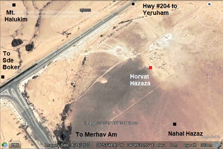
Location and Map:
The site was built on a low hill 4km northwest of Sde Boker, near the entrance to the community of Merhav Am.
History:
- Biblical periods
This site is located on the side of an ancient desert trade route. The route, now highway #204 from Sde Boker to Yeruham, may have been the Biblical ‘Way of the Atharim’—the major north-south artery mentioned in the Bible. This legendary route ascended from the Arava Valley through the Ramon Crater, cutting through these highlands near Sde Boker and Yeruham on its way via Aroer to Beer Sheba and Arad.
A Biblical map is shown here, with the route marked with an orange line. The site is marked with a red and black square, south of Mt. Halukim (here:”Mt Halak”).
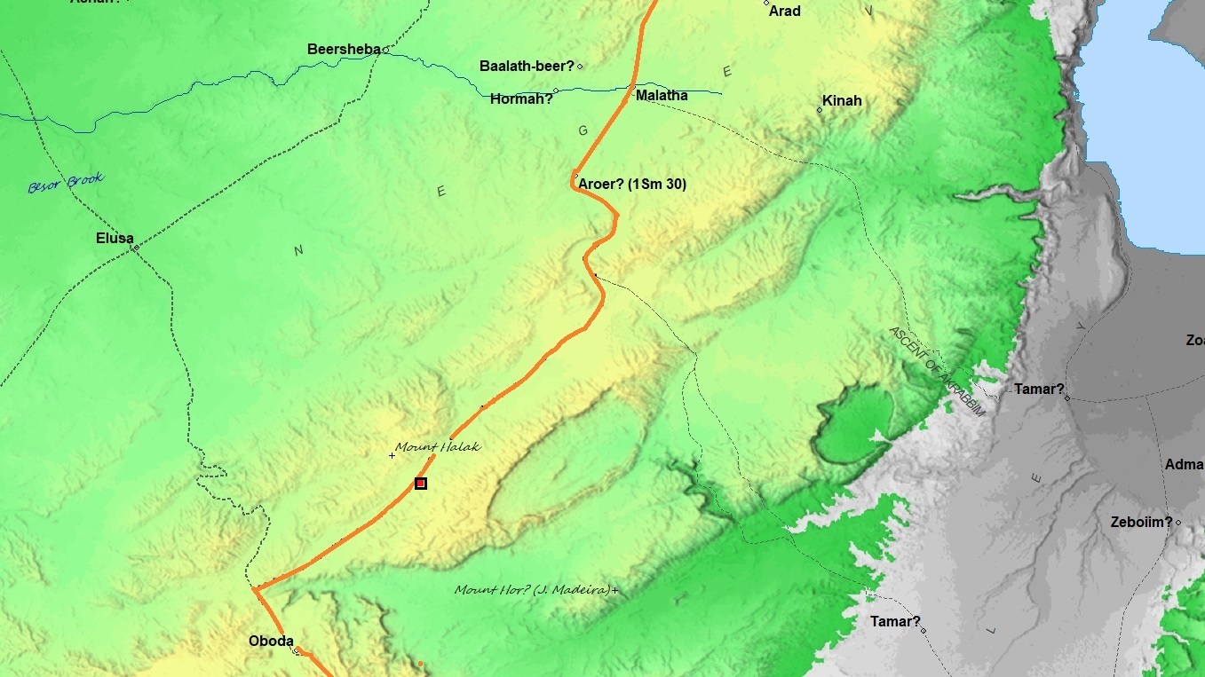
Way of the Atharim (based on Bible Mapper 3.0)
- Roman period
The structure was occupied from the 2nd century thru the 4th century. It was a Nabatean station along the road from the Avdat (Oboda) to Yeruham.
Excavations were conducted in 1971, headed by R. Cohen, with assistance of the students of Midreshet Sde Boker.
- Modern period:
Merhav Am, a religious community settlement, was founded in 2001 and was built near the site. It was first named Halukim, based on the nearby ruin. The name was changed to Merhav Am, where Merhav means an open area, while Am is a short form of Rechavam, honoring the late minister Rechavam Ze’evi who was assisisnated in 2001.
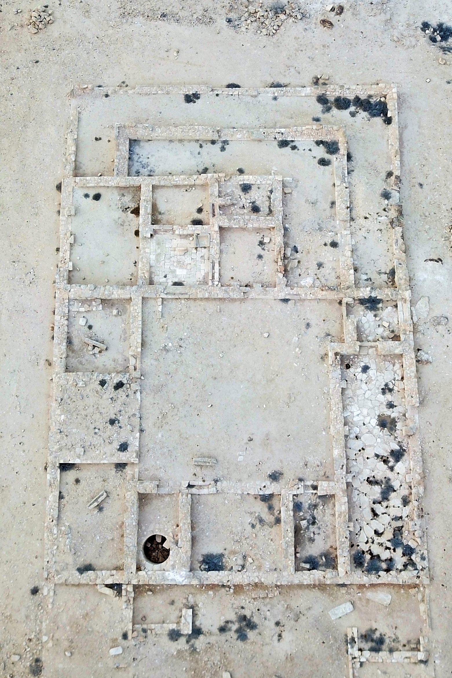
Plan:
(a) General Plan
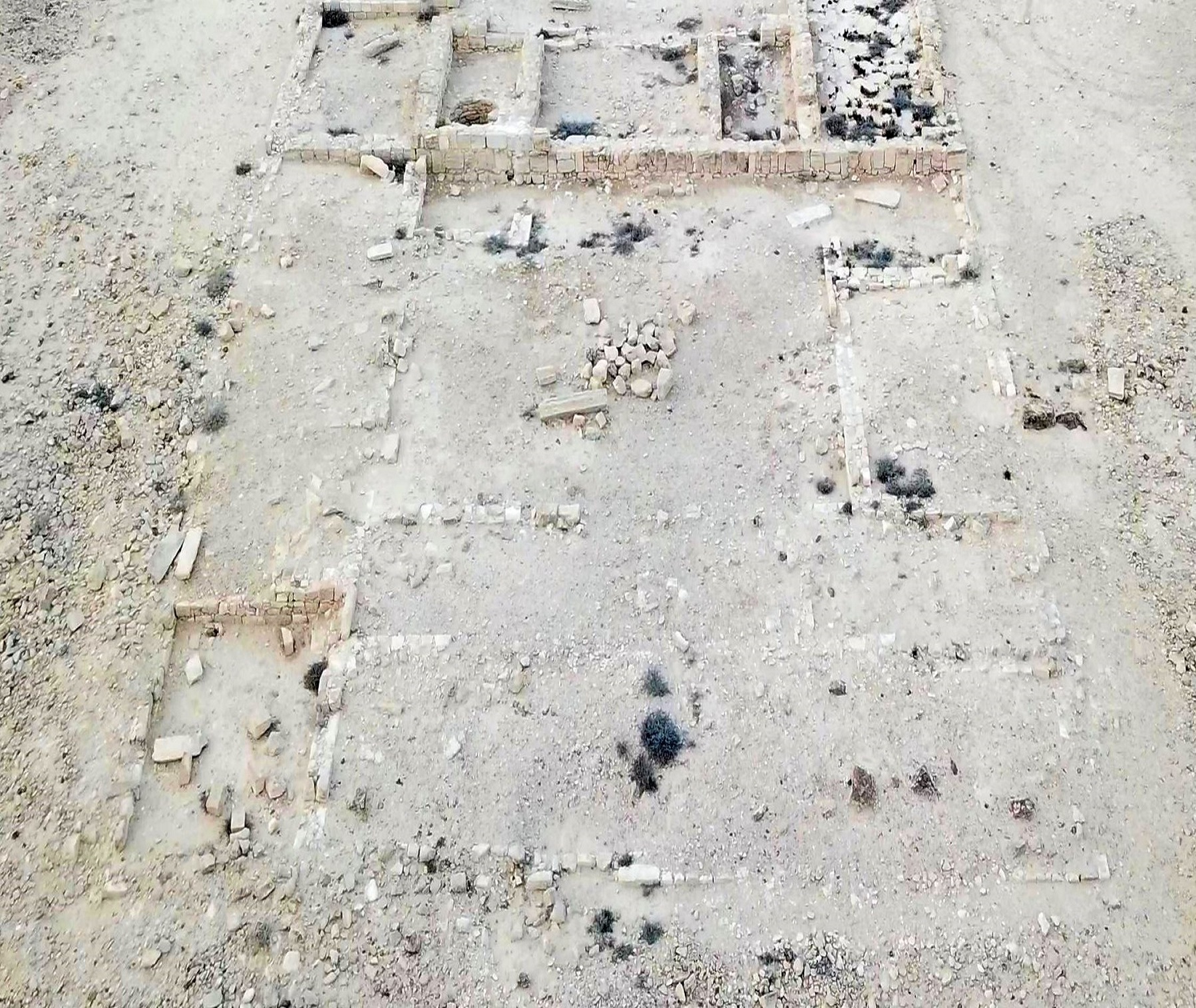
The site features a rectangular plan covering an area of 22 meters by 51m. It is oriented north-west to south-east.
It consists of two distinct wings – North and South. Each wing has a separate entrance leading to a central courtyard surrounded by rooms and halls. No passage was found connecting the two wings. The building is constructed of ashlar masonry (hewn stones).
Click on the photos to view in higher resolution…
Each of the wings are detailed here:
(b) The Northern Wing
Measuring 33 x 22 meters, this wing comprises 12 rooms and 5 long halls arranged around a central courtyard (11 x 11 meters).
- Entrance: Located in the center of the western wall, the entrance room is paved with large, coarse stones.
- Water Basin: In the southwestern corner of the entrance room, a large water basin is hewn into a stone block.
- Bench: A low stone bench, 2 meters long, stands along the northern wall.
- Internal Layout: From the entrance room, doorways lead to the courtyard and a large hall, which is also paved with large, coarse stones.
- North of the courtyard: Five rooms, one of which is paved with finely dressed stones. The archaeologists found a juglet, parts of decorated oil lamps, and basat grinding stones.
- Several long halls are located to the north and west of these rooms.
- South of the courtyard: A row of three rooms; the middle room is relatively large (5.20 x 4.30 meters). The eastern room contains a plastered cistern with a diameter of 1.65 meters.
- East of the courtyard: Another row of three rooms. One of the rooms was a basalt grinding installation for tehina, and a water vessel.
(c) The Southern Wing
This wing, measuring 18m by 22m, is attached to the southern wall of the Northern Wing.
- Entrance: A large entrance room in the west (3.50 x 3.50 meters) leads to a central courtyard (11.50 x 9.50 meters).
- Internal Layout:
- East of the courtyard: A row of three rooms.
- South side: Two long halls.
- West side: In addition to the entrance room, there is another large room (5.50 x 3.50 meters).
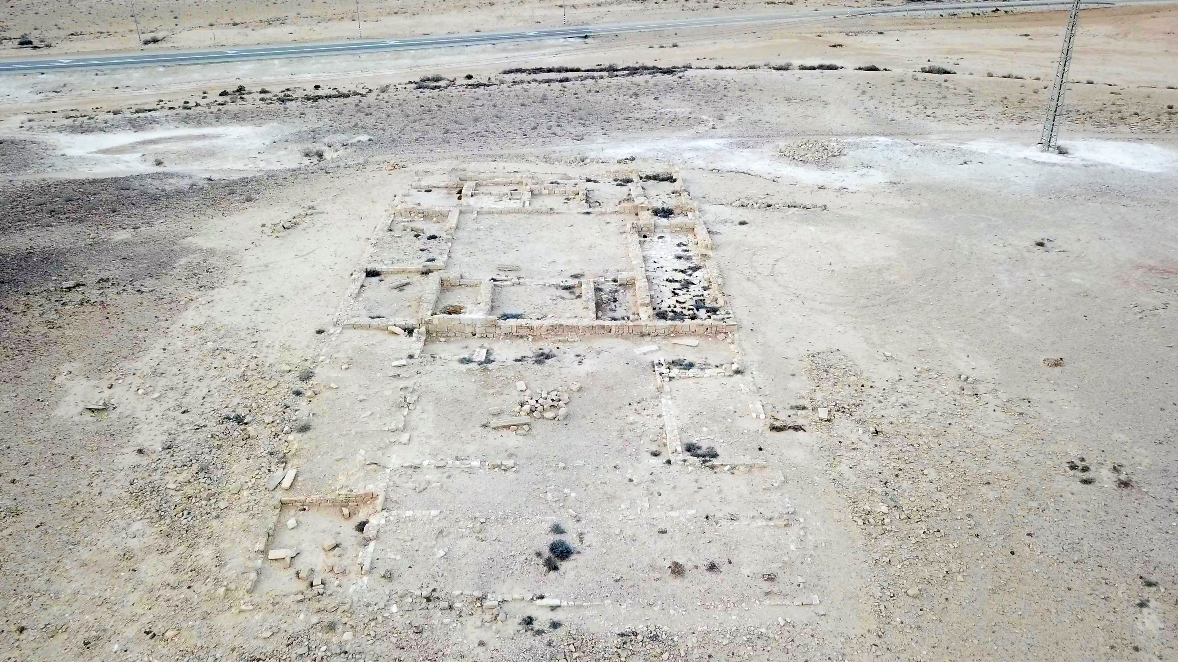
Videos:
This is an aerial view of the site, captured on Nov 2018:
Etymology (behind the name):
* Names of the area:
- Hazaza – from Arabic – Hazaz, meaning: gravel
- Nahal Hazaz – this brook passes on the south side of the hill, joins Haro’a brook that flows to the Besor river
- Merhav Am – the community settlement near the site, named after Rechavam Ze’evi
- Halukim (Haluqim) – Hebrew: pebbles. The modern Hebrew name is based on the Arabic name of the hill – Jebel Haleiqim – and the valley – Wadi Haleiqim.
Links and References:
* External links:
* Internal links:
- Horvat Halukim – nearby site
- The Nabateans – info page
- Map of Nabatean sites in Israel
![]()
BibleWalks.com – Sites of the Nabatean history
Yeruham overview <—previous Negev site—<<<All Sites>>>—next Negev site —>Horvat Haro’a
This page was last updated on Mar 21, 2026 (new page)
Sponsored links: