Ruins of a Israelite period desert fortress and small settlement, near the confluence of Nahal Haro’a and Mezadim streams.
Home > Sites > Negev > Horvat Haro’a
Contents:
Background
Location
History
Photos
* Aerial view
* Fortress
* Commander’s house
* Circular Area
* The Valley
* Nature
* Video
* Nearby sites
Etymology
Links
Overview:
Horvat Haro’a (“The shepherdess ruin”) is a significant Iron Age archaeological site located in the Negev Highlands, approximately 5 kilometers northeast of Sde Boker. This Iron Age IIa desert fortress sits on a strategic hill overlooking the ancient route along Nahal Haro’a, and may have been built during the periods of David or Solomon and destroyed by pharoah Shishak.
Location and Map:
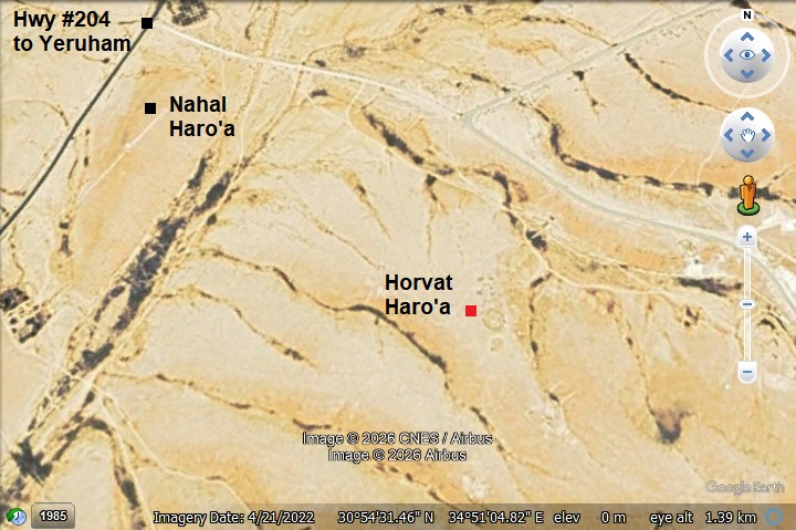
The site is located about 5KM northeast of Kibbutz Sde-Boker. Access to the site is from a dirt road that starts from highway #204 (Sde Boker-Yeruham) and continues east, then a short walk off road.
History:
-
Iron Age IIa period (1000-925 BC)
In the Negev area are over 40 fortresses of small to large sizes that were identified as “Israelite fortresses’ and dated to the Judean Kingdom period. The majority had common features – located near major trade routes, a plan of central courtyard with casemate rooms, have been built around the 10th century BC, and had small 4-room houses were built at their side.
The fortress of Horvat Haro’a is one of these small forts. The fortress, built in the 11th-10th century, overlooked a valley where a major trade route passed. Several dwelling structures were built around the fortress. The site existed for a short period.
- Who built the desert fortresses?…
Who built this fortress, as well as others in the desert area? Scholars offer various identifications. Some relate their construction to the royal administration of the Judean Kings, such as David and Solomon (only the small forts, such as this site), or to Jehoshafat (870-849 BC) and Uzziah (mid 8th century) for the larger fortresses with towers. The fortresses offered protection on the major trade routes and established control and royal presence.
- “Way of the Atharim” trade route
Scholars believe the forts along this route via Yeruham guarded the ‘Way of the Atharim’—the same major north-south artery mentioned in the Bible. This legendary route ascended from the Arava Valley through the Ramon Crater, cutting through these highlands near Sde Boker and Yeruham on its way to Tel Arad, Aroer and BeerSheba. It is shown on the map below as an orange line.
We find its first mention in Numbers 21:1, which describes the King of Arad hearing that Israel was approaching along the ‘Road to Atharim.’ “When the Canaanite king of Arad, who lived in the Negev, heard that Israel was coming along the road to Atharim, he attacked the Israelites and captured some of them.” He launched a strike here, marking one of the first organized military resistances the Israelites faced on their journey to the Promised Land.
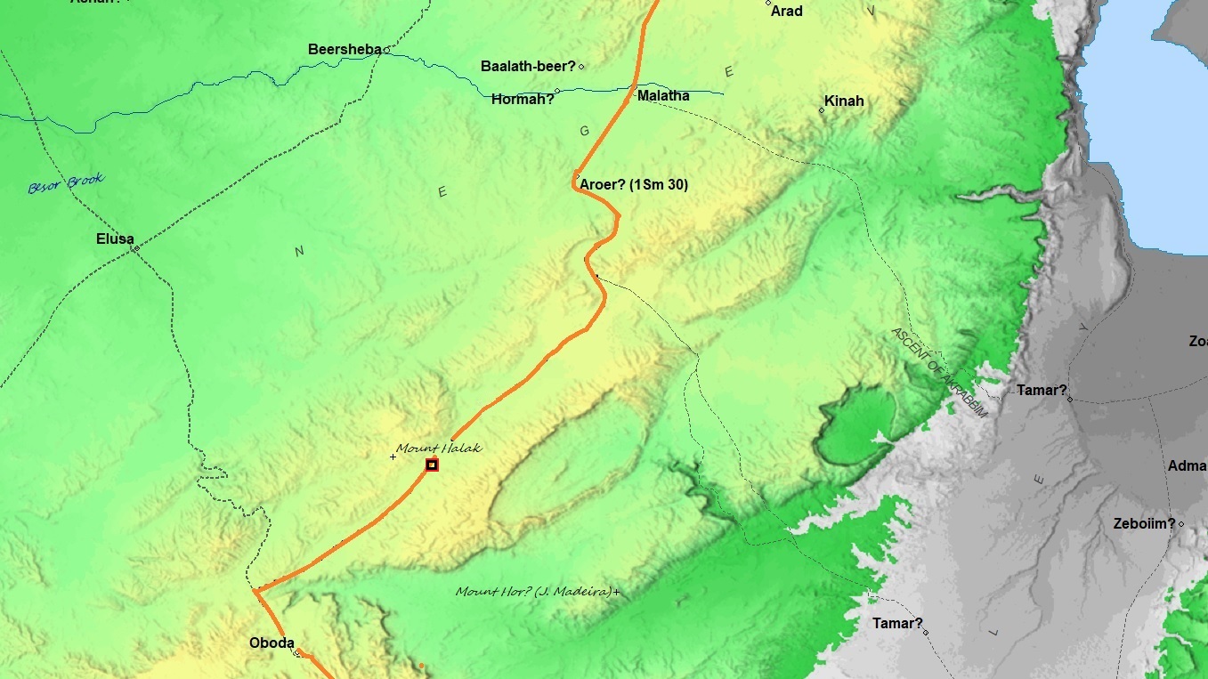
Way of the Atharim – orange line (based on Bible Mapper 3.0)
-
Plan of the site
The central feature of the site is a large, oval-shaped fortress. Its long diameter is 50 meters, and its short diameter is 42 meters. The fortress is constructed with casemate walls (double walls divided into rooms). Excavations revealed 17 rooms within these walls, with an average width of 2.5 meters and lengths varying between 5 and 10 meters. Archaeologists believe these rooms served as quarters for the soldiers stationed there to protect the desert road.
Additional Structures: Outside the fortress, researchers found 12 other buildings. Most are simple one-to-four-room structures. One of the buildings is a 5-room structure, suggested to be the commander’s house.
It is likely that the Negev desert fortresses, such as this site, were destroyed during the Egyptian invasion of Shishak (926 BC), who swept through the kingdom of Judah (Bible: 1 Kings 11:40; 14:25-26; 2 Chronicles 12:2-9).
- Nearby Iron Age sites
This important desert route was protected by other Iron age fortresses. A nearby site is in Horvat Halukim, 5km south west of the site. See other sites in the info page on Negev desert fortresses.
- Persian period
Remains of a Persian period fortress are located 300m north east of this site.
- Nabatean/Roman
Ruins of a Nabatean/Roman station are located 2km south west of the site, on the side of the desert trade route to Yeruham. Visit Horvat Hazaza for more information.
- Modern period
The site was first surveyed in 1965 by a team led by Rudolf Cohen. Excavations were carried out that same year and again in 1967 on behalf of the Department of Antiquities (now the Israel Antiquities Authority).
The site is open to the public, accessible by car and foot.
Photos:
(a) Aerial Views
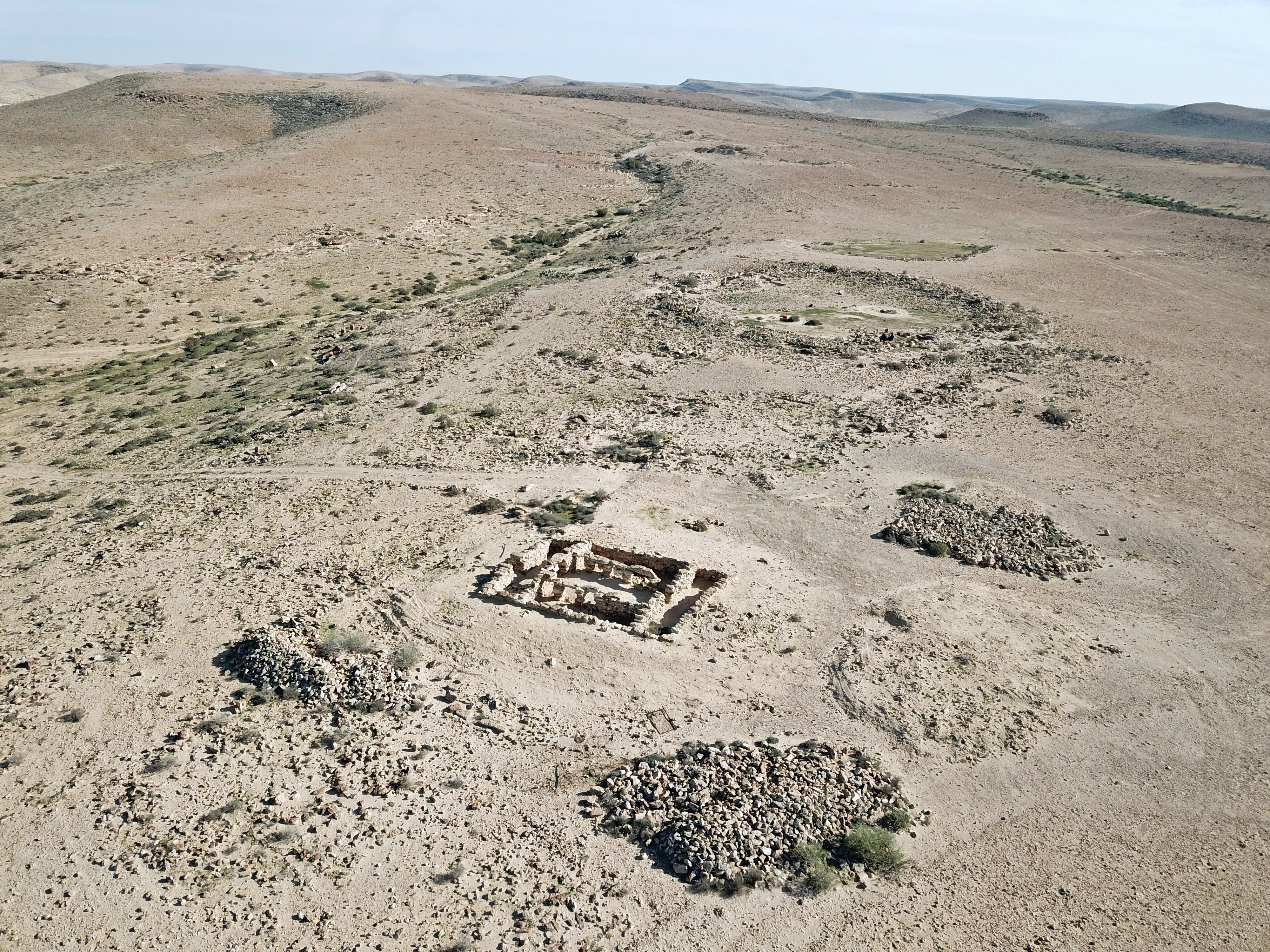
A drone captured this view of the site from the north side. The site stretches 200m on the west side of the valley, and its width varies from 50m (north side) to 100m (south side). Excavations were conducted in limited areas, revealing only one archaeological layer across the whole site.
Click on the photos to view in higher resolution…
The major points of interest are marked on this aerial view.
The next aerial view is looking north. The aerial perspective reveals a deep valley cutting along the eastern flank, roughly 10 meters below the site’s elevation. This layout is a hallmark of Negev highland fortifications: by utilizing the natural topography of the wadis, the builders gained a defensive advantage while simultaneously positioning themselves to harvest and store precious runoff during the desert’s occasional flash floods.
The ancient road passed along the foothills 500m north of the site, seen here in the far background.
(b) The fortress (building I):
The central feature of the site is a large, oval-shaped fortress. Its long diameter is 50 meters, and its short diameter is 42 meters. The excavator marked it as building I.
The fortress is constructed with casemate walls (double walls divided into rooms). Its walls are 0.5m, made with coarsely cut local flintstones. There are a total of 17 casemate chambers, with an average width of 2.5 meters and lengths varying between 5 and 10 meters. Archaeologists believe these rooms served as quarters for the soldiers stationed there to protect the desert road.
On the following aerial view, oriented to the north, are two sections of the casemate wall that were exposed: area ‘A’ on the right (east) side, and area ‘B’ on the left (west) side.
Fortress – area A:
The following photo shows area ‘A’ on the east side. A long chamber (number 10) is 10.2m long and 2.5m wide. Its walls are 0.4-0.5m wide and preserved to a height of 0.7m. The walls are made of flintstones,
An aerial view of chamber 10 is seen below. An opening from the room to the courtyard (marked with a white arrow) is located in the center of the western wall, and is flanked by larger stone blocks.
On the north side of the chamber was the entrance to the fortress. The opening, 1m wide, is marked with a black arrow. The wall of the gate was constructed of extra large stones, each 80 x 50 x 25 cm.
Fortress – area B:
The following photo shows a section of chamber 12 inside the exposed area ‘B’ on the west side of the fortress. This room is unique as it is the only room that extends from the casemate wall into to the courtyard. It is 5.5m long and 3.3m wide, with walls that were preserved to a height of 0.6m. On its floor the excavators found pottery sherds and 2 installations.
(c) Building II – Commander’s house?
Outside the fortress, researchers found 12 other buildings. Most are simple one-to-four-room structures.
One building, located 50m north of the fortress, stands out for its unique five-space layout (4 rooms around a central courtyard). It appears to be a variation of the classic Four-Room House, typical of the Israelite Iron Age.
Rudolf Cohen, the primary excavator, suggested this larger, more complex building might have served as the residence for a regional commander.
The building was preserved to a height of 1.5m. The archaeologists suggested that the ceiling was 1.8m-2.0m high, and the roof was supported by wooden beams that did not survive.
The building covers an area of 12m by 8m. The walls are 60cm wide, and are built with flintstones that are arranged in a pattern of one course of headers (stones laid with their short end facing outward) and one course of stretchers (stones laid with their long side facing outward).
Below is a view from the north west side. This room on the back of the building (number 19 according to the survey report) is 7m long and 2m wide.
A northwest view of the building is next. The room along this wall (number 17) is 6.6m long and 1.5m wide.
Another northeast view of room 17, on the north side of the building, shows an opening to the central courtyard (room 16).
Entrance to the building is on the east side. It opens to room 15.
A view of the eastern wall below. The entrance is 1m wide.
The walls on both sides of the entrance extend 70cm outside of the building.
The floor of the building is pressed ground. Above the floor was a layer of 20cm of ash and fragments of pottery sherds. The largest layer of ash was in the entrance room (15), while most of the pottery remains were found in the northern room (17) and also in the courtyard (16).
A grinding stone was found in one of the rooms.
(d) Building III
Another building was exposed on the southern coner of building II with 1m a shared wall. It had 3 or 4 rooms, and shares a large (25 x 17m) external courtyard with building II. According to the findings of storage vessels, it was suggested that this building served as a storehouse of building II.
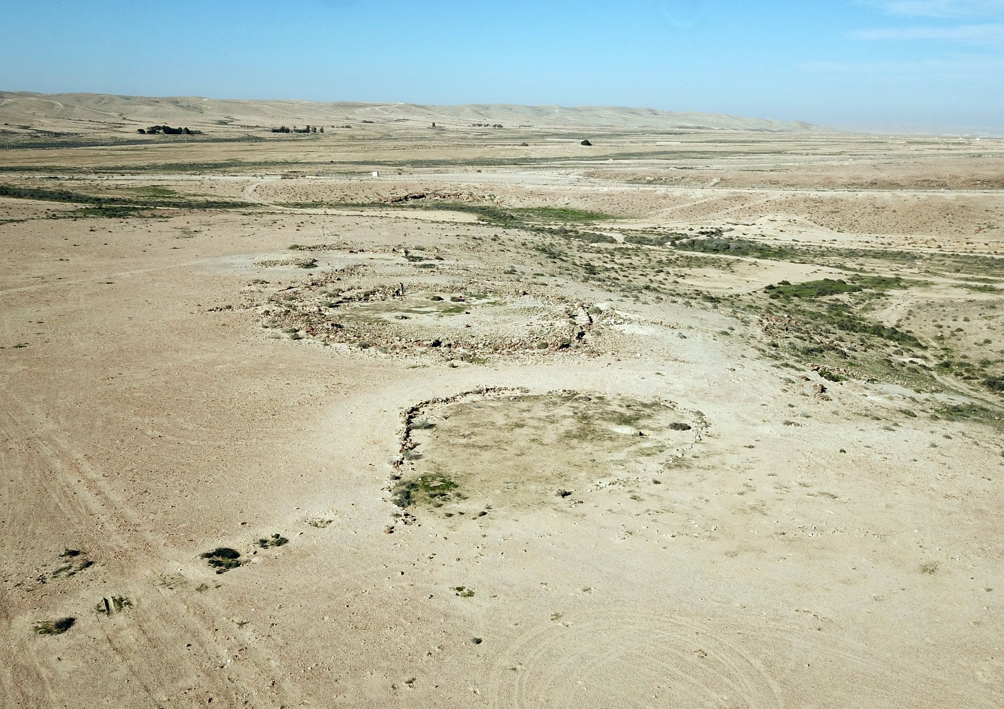
(e) Large circular area
A large circular open area is located south of the fortress. Its diameter is about the same as the area of the fortress.
The area is surrounded by a law wall.
(f) The valley
The village was built along the valley. Water cisterns (Ma’agura) were built along the bank of the valley to capture and stoire run off water.
A Ma’agura (from the Hebrew root agar, meaning “to collect” or “store”; in Arabic called a harabe) is a water cistern hewn into a rocky slope. Some cistern feature rock-cut stairs leading down into its interior. These cisterns are designed to collect and store surface runoff. Typically, a Ma’agura is constructed on the bank of a wadi (stream bed), where seasonal floodwaters are diverted into its opening via a system of conveyance channels.
Ma’agorot can be found in many locations across the Land of Israel. They are particularly characteristic of the Negev—for example, at Nahal Havarim, Mezad Ma’agura near Sde Boker, and the Borot Lotz (Loz Cisterns).
Around the site are terraces, walls, and farming areas.
(g) Nature
We noticed a desert lizard. Its gray-brown, speckled pattern is specifically adapted to blend into the flinty, rocky soil of the Negev.
(h) Flight over the site:
![]() The following YouTube video shows a flight of a drone over the site.
The following YouTube video shows a flight of a drone over the site.
(g) Nearby sites
Other nearby Iron Age IIa period fortresses – Horvat Halukim, Horvat Ritma, Ramat Boker.
Etymology (behind the name):
- Sde Boker, Sede Boqer – Kibbutz, established 1952.Meaning (Hebrew): herding field.
- Haro’a -Meaning: Shepherdess. Named after Barbara Propper, one of the founding members of Kibbutz Sde Boker in the eraly 1950s.She took on the difficult and solitary role of a shepherdess, grazing the kibbutz’s flock in the rugged desert terrain. In 1952, while tending to her flock near the hills where the ancient site now stands, she was tragically killed by local Bedouin infiltrators. To honor her memory and her connection to the land, the nearby stream was named Nahal Haroa (Shepherdess Stream), and the ancient Iron Age fortress discovered on the ridge above it became known as Horvat Haroa (The Shepherdess Ruin).
Links and References:
* External links:
- Atar Haro’a – Rudlph Cohen, Atiqot Volume 6 1970 pp. 6-24
- Archaeological Survey of Israel – Map 167 (Sde Boker West) – site 64 – Horvat Haroa (Hebrew)
- Who built the Israelite fortresses in Negev heights? – Zeev Meshel, 1975 (Hebrew, pdf) – a thorough review of the site
- Sde Boker – Home page of the Kibbutz (Hebrew)
* Other Iron Age II desert fortresses in BibleWalks:
- Ramat-Boker fortress
- Halukim
- Negev Iron Age fortresses – overview of Iron Age II desert fortresses
* Other Internal links:
- BibleWalks YouTube channel – join!
BibleWalks.com – Search for the lost cities of the Bible
Horvat Hazaza<<<—previous site—<<<All Sites>>>—Next Negev site—>>>
This page was last updated on Mar 23, 2026 (New site)
Sponsored links: