This overview page reviews ancient sites on Mt. Poriya.
Home > Sites > Sea of Galilee> Mt. Poriya (Poria)
Contents:
Background
Location
History
The Sites
* Horvat Menorim
* Tel Kedesh
* Poriya Spring
* Round Tower
Etymology
Links
Background:
This overview page reviews ancient sites on Mt. Poriya, overlooking the south west side of the Sea of Galilee. The settlements reviewed are from the Bronze period and the Iron age.
Location:
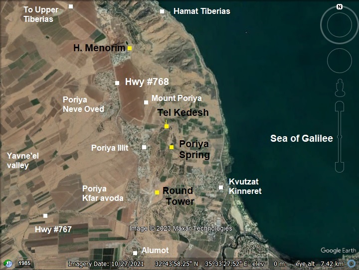
The sites reviewed in this page are marked with a yellow square on this aerial map.
Mount Poriya, or Poriya heights, is an elongated ridge towering above the Sea of Galilee on its east side and the Yavne’el valley on its west side. Its highest point is on the north side, south of Tiberias, is ~240m above sea level, or about 460m above the lake. On the south side, at Alumot junction, its height drops to 20m. This lowest point is where highway #767 descends along a serpentine road down to Kvutzat (Kibbutz) Kinneret.
History:
- Biblical periods – Bronze/Iron Age
The settlements that are reviewed in this web page are from the Biblical periods. A Biblical map is shown here, focusing on the area west and south of the Sea of Galilee. Mt. Poriya is indicated by one of the four reviewed sites in this page – marked as “Kedesh-Naphtali”.
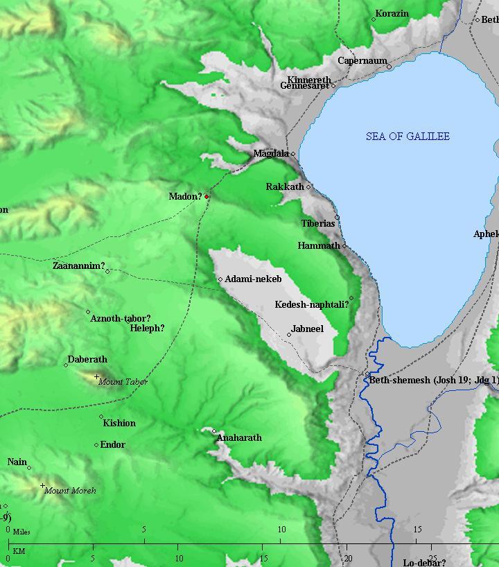
Roads and cities during the Canaanite/Israelite periods thru the Roman period, 20th BC- 1st century AD (based on Bible Mapper 3.0)
- Ottoman period
Conder and Kitchener surveyed this area during the Survey of Western Palestine in 1882. A section of their map is seen here, on the south west corner of the Sea Of Galilee. The sites reviewed in this page is el Menarah (Tel Menorim) and Kh. Kadish (Tel Kedesh), located on Mt. Poriya overlooking the lake. All these sites were ruined during that time.
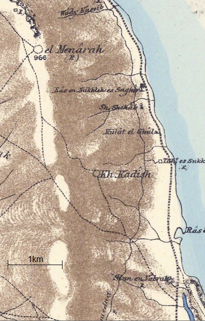
Part of map Sheet 6 of Survey of Western Palestine,
by Conder and Kitchener, 1872-1877.
(Published 1880, reprinted by LifeintheHolyLand.com)
-
Modern Age
The area of Mt. Poriya started to be populated after the establishment of the State of Israel. These are the communities on Mt Poriya:
- Poriya Illit is a village situated on the slopes of Mt. Poriya in the northern part of Israel. It is located just west of the city of Tiberias and overlooks the Sea of Galilee. The village is known for its tranquil atmosphere, picturesque views, and proximity to nature. Poriya Illit offers a peaceful and scenic environment, making it an attractive residential area for those seeking a quieter lifestyle away from larger urban centers. The village features a mix of residential housing, community facilities, and green spaces. Its elevated position on the slopes of Mt. Poriya provides residents with beautiful vistas of the Sea of Galilee and the surrounding landscapes.
- Poriya Neve Oved is another community, north west of Poriya Illit.
- Poriya-Padeh is a medical center and hospital south of Poriya Illit.
- Poriya Kfar Avoda are 4 small communities south of Poriya Illit.
The Sites:
(a) Horvat Menorim
Horvat Menorim (Kh. el Menara – “The light House”) is an archaeological site, situated on a cliff overlooking the Sea of Galilee. The mound is located behind Poria-Pade medical center, 2km south and 470m above the city of Tiberias.
An aerial view of the ruin was captured from the south side. The site is located on a mound that is seen in the center of the view. On the right (east) side is the Sea of Galilee, while far in the north is the city of Tiberias.
The site covers an area of 30 dunams (3 Hectares). Several new open trenches are seen in this view on the south west side of the site where an additional reservoir is planned to cut a section of the mound.
Across the mound are traces of structures, terraces, installations, pottery and basalt stones. The limited excavations dated 2 major periods of settlement: Early Bronze IB (3330-3100 BC) and the Iron Age (1000-596 BC).
- Flight over the site:
![]() Fly above and around the site with this YouTube video.
Fly above and around the site with this YouTube video.
The drone scans the site starting from the southern foothills side, turns around the eastern side of the hill, then around to view the Sea of Galilee.
(b) Tel Kedesh:
Tel Kedesh (Khirbet Qadish) is an archaeological site located on the foothills of the Poriya ridge, 220m above the Sea of Galilee. On the site are traces of structures and walls built with basalt stones.
An aerial view of the site and its surroundings is seen below, as captured from the east side. The ruin covers a large area bounded by the orchards. On the hill on the far background are the residential houses of Poriya Illit.
Ceramics were dated to the Bronze and Iron ages as well as later periods.
Some Scholars, such as Y. Aharoni, suggested that this ruin was the Biblical Kedesh Naphtali (Joshua 20:7): “Kedesh in Galilee in mount Naphtali”. However, another identification of Kedesh Naphtali is in the Upper Galilee near the border of Lebanon.
(c) Poriya Spring:
About 0.6km south of Tel Kedesh is a perirenal spring named Poria spring (Ein Poriya). It was the main source of water for Tel Kedesh.
The KKL-JNF drained the water from the muddy slopes of the spring and created this pool.
An observation point is nearby, commemorating Naomi Shemer, a leading Israeli musician and songwriter who was born in the nearby Kvutzat (Kibbutz) Kinneret.
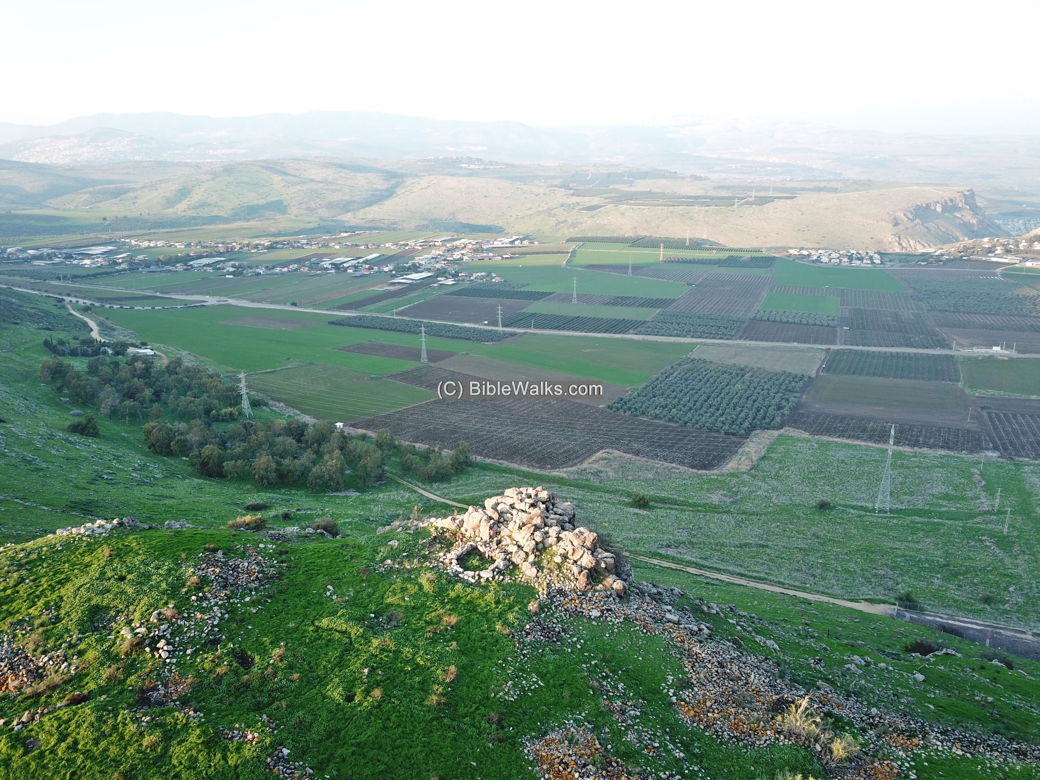
(d) Round Tower:
On Mt. Poriya, overlooking the southern side of the Sea of Galilee, are large earth works of a new residential neighborhood of Kfar Avoda. The new neighborhood is built along the foothills above highway #767 that descends to the Kinneret junction.
On a small hillock are remains of a unique tower dated to the Iron Age I-IIa period. An ancient road led to the site from the west side. Remains of walls were unearthed north of the hillock. Iron Age and Roman pottery fragments were found around the site.
The tower is 19m in diameter, and built of 3 concentric walls, with small fieldstones in between. Pottery fragments that were dated to the Iron age – the time of its construction. Between the concentric walls are radial walls. Round towers of the Iron Age are rare, and were found to date only in 3 other locations in Israel – Kh. Makhruk, Rujim abu Mukheir, and Kh. Umm Ghazal (esh-Shakk).
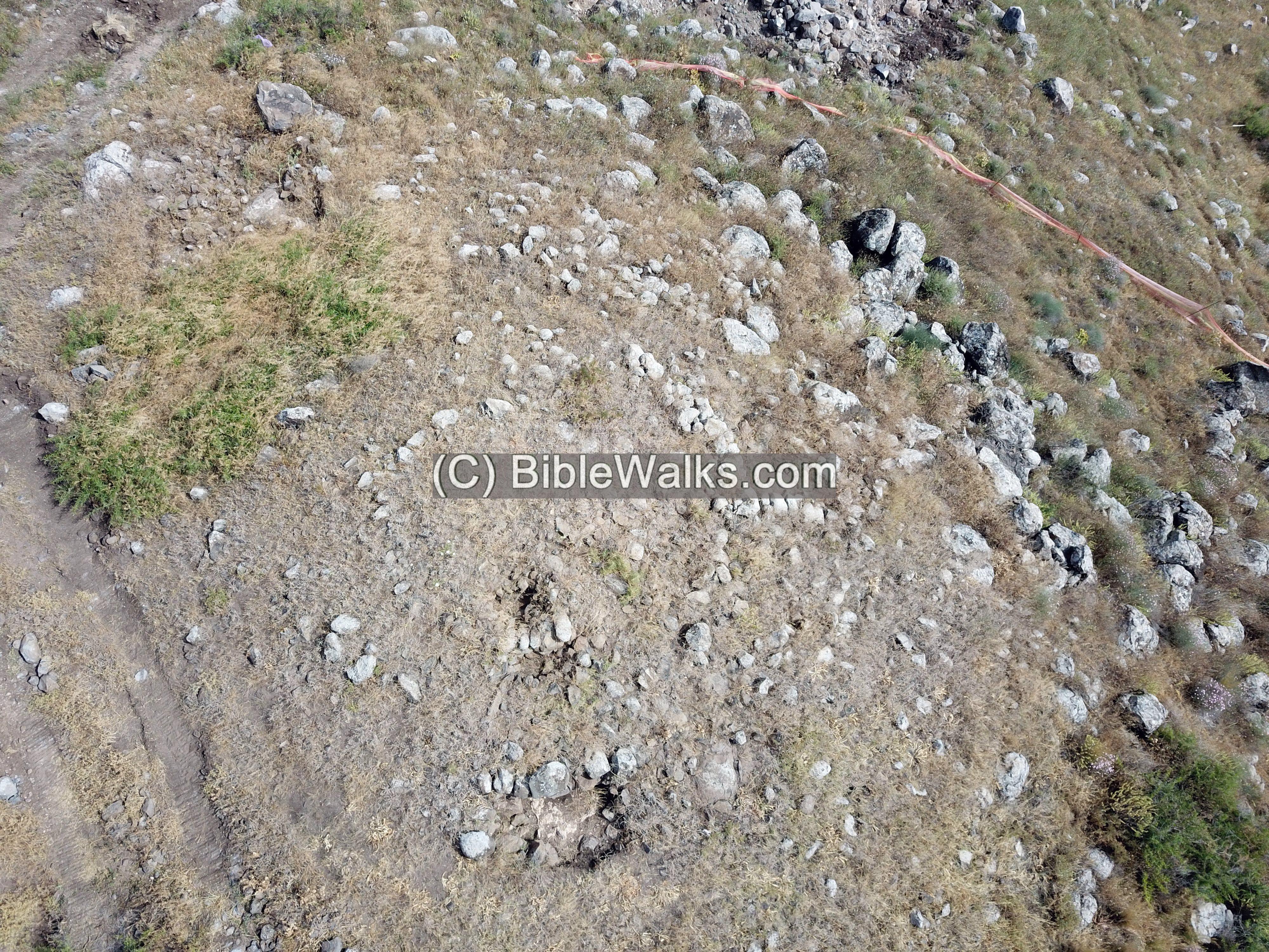
Although the modern earthworks damaged the fringes of the site, we hope that it will be preserved and incorporated as an archaeological park.
- Flight over the site:
![]() Fly above and around the site with this YouTube video.
Fly above and around the site with this YouTube video.
The drone scans the site starting from the eastern foothills side towards Poriya, then turns around to view the Sea of Galilee.
Etymology (behind the name):
- Poriya – Hebrew: fertile. Based on the Hebrew word Pri (fruit), meaning fruitful.
- Poriya – a number of communities above the south western side of the Sea of Galilee share this name:
- Poriya Illit – Hebrew for: upper Poriya. Established in 1955.
- Poriya-Padeh Medical center – founded 1955. Prof. B. Padeh headed the hospital for 2 years.
- Poriya Neve Oved – Hebrew for: Poriya worker oasis. Village was established in 1949.
- Poriya Kfar Avoda – founded in 1949, and is built in several sections along highway #768
Links:
* Archaeological:
* Other:
- Map of the sites
- Other Iron Age round towers: Kh. Makhruk, Rujim abu Mukheir, and Kh. Umm Ghazal (esh-Shakk)
* Nearby sites:
BibleWalks.com – walk with us through the sites of the Holy Land
Kankuza<<<–previous Sea of Galilee site—<<<All Sites>>> —-next Sea of Galilee site –>>>Tell Kinneret
This page was last updated on July 29, 2024 (add round towers links)
Sponsored links: