Iron Age IIa period desert fortress in the Negev.
Home > Sites > Negev> Iron Age Negev fortresses
Contents:
Background
Location
History
The Sites
* Nahal Avnon
* Horvat Ritma
* Horvat Halukim
* Mt. Eldad
* Ramat Boker
* Be’erotayim
Etymology
Links
Overview:
This page is an overview of Iron Age IIa period desert fortress in the Negev.
Location and Map:
The sites featured in this page are marked on this Biblical map.
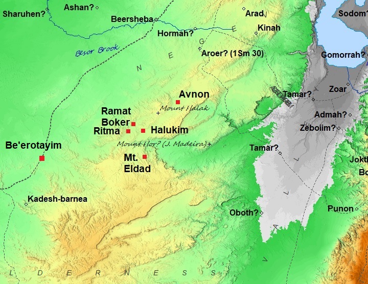
Map of the area around the site (marked by red square) – during the Roman/Byzantine periods (based on Bible Mapper 3.0)
- Desert Routes
The fortresses of the Negev Highlands were strategically constructed along major desert arteries that connected the Arava Valley—a source of copper and a gateway to the Red Sea—to the heart of Judea. The Four Primary Routes (North to South):
A. The Zoar Route (The Ascent of Luhith / Scorpions)
-
Path: Leads from Zoar at the southern tip of the Dead Sea, climbing westward toward the Judean hills. Marked on the map above.
-
Context: This was a vital link for the transport of salt and bitumen from the Dead Sea, as well as goods coming from Moab. It likely connected toward the Hebron hills via the Zohar and Hemar stream beds.
B. The Tamar–Aroer Route (The “Ma’ale ‘Akrabbim” Axis)
-
Path: From Hatzeva (Biblical Tamar) in the Arava, ascending through the passes between the Small Crater (HaMakhtesh HaKatan) and the Large Crater (HaMakhtesh HaGadol), reaching Aroer. Marked on the map above
-
Context: This route was protected by a string of Iron Age fortresses. It provided a direct line for copper transport from the mines at Punon (Feinan) toward the administrative center at Arad.
C. The Central Highlands Route (The “Way of the Sites”)
-
Path: From the Arava, crossing the Ramon Crater, passing through the Yeruham region while bypassing the Large Crater, and splitting toward Aroer/Arad to the north and Kadesh Barnea to the west.
-
Context: Scholars often identify this as the biblical “Derekh Ha’Atarim” (Way of the Sites). The density of fortresses here—like those at Ramat Matred and Har Halukim—suggests this was a high-traffic royal road, likely used for the Arabian incense trade.
D. The Kadesh Barnea Route (The Southern Gateway)
-
Path: A more southern lateral route connecting the Arava directly to the massive fortress at Kadesh Barnea (Tell el-Qudeirat). Marked on the map above
-
Context: Kadesh Barnea was the largest and most significant Iron Age stronghold in the region, serving as a border outpost and a central hub for controlling the nomadic tribes of the Sinai and Negev.
Additional Geographical Context:
-
The Ascents (Ma’alot): The primary challenge for these routes was the “Stepped Ascent.” The Iron Age engineers chose routes where the limestone cliffs of the craters could be scaled by pack animals.
-
The “Darab el-Sultane”: Many of these Iron Age routes remained in use for millennia, eventually becoming known in the Ottoman period as the “Sultan’s Road.”
-
Water Security: Each route was dictated by the location of reliable cisterns and seasonal wells, many of which were rock-cut during this specific period to support permanent garrisons.
History:
- Iron Age IIa – The fortified enclosures during the United Monarchy
During the period of the United Monarchy, the Central Negev Highlands experienced a surge of rapid and widespread settlement. This rugged landscape—bounded by the Nahal Zin cliffs, the Machtesh Ramon crater, and the Kadesh Barnea oasis—became home to dozens of unique structures that continue to spark debate among historians today.
Archaeologists have identified and surveyed approximately 50 fortified enclosures, often termed “fortresses.” Near this site, just a few kilometers to the north, are additional Iron Age fortresses – Givat Refed and Hatira fortress. There are more Iron Age IIa fortresses in Nahal Boker area to the south of this site. Several of those are reviewed in BibleWalks.com: Ritma, Ramat Boker, Halukim, Mt. Eldad.
- Common Structure
Key characteristics of these sites include:
- Location: Built on hilltops within sight of one another, usually near wadi beds or water sources.
- Architecture: Most range from 25–70 meters in diameter, with shapes (circular, oval, or triangular) dictated by the natural contour of the hill.
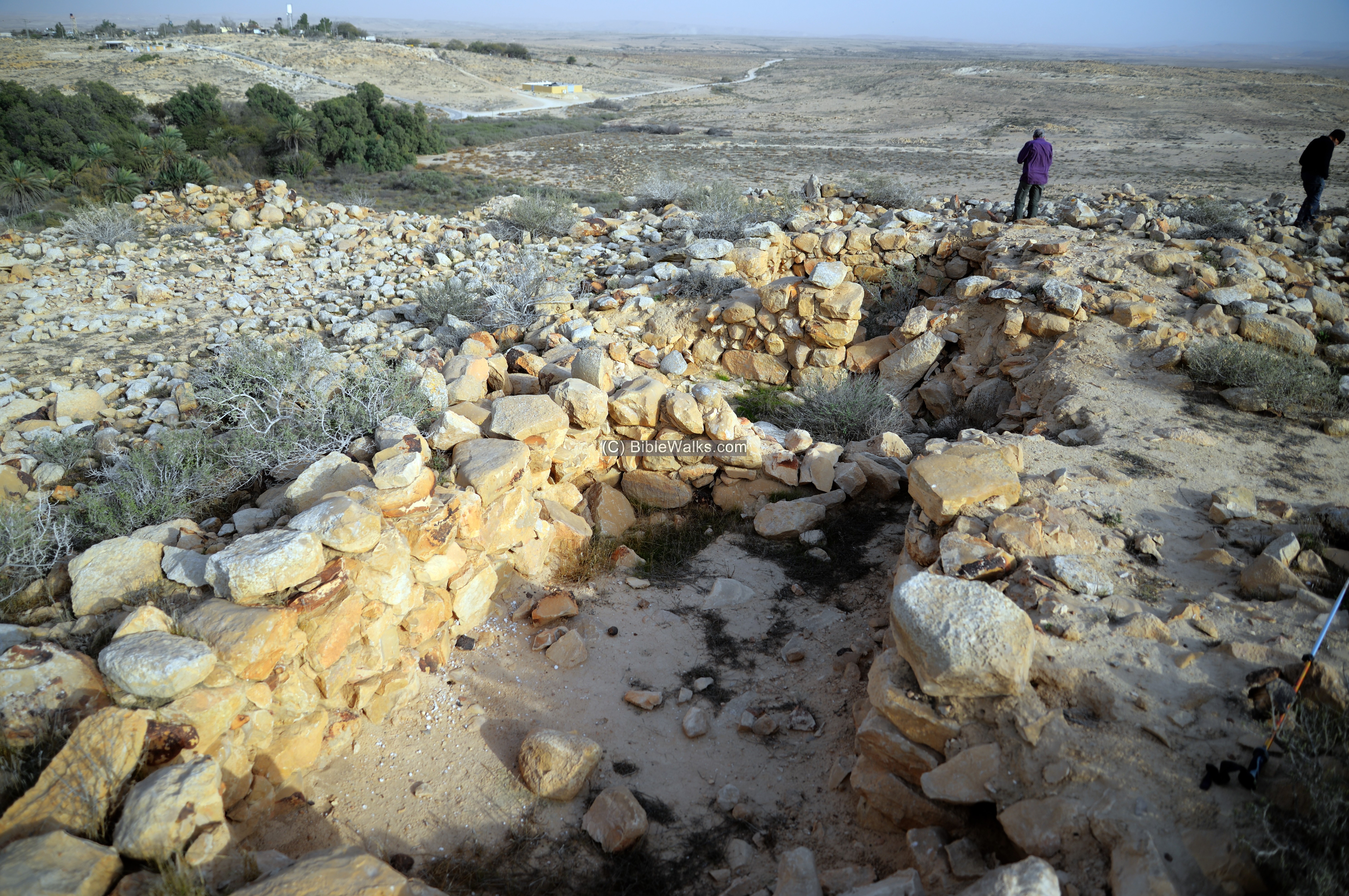
- Layout: They typically feature casemate walls (double walls divided into rooms) surrounding a large central courtyard accessed via a narrow entrance.
A casemate wall is ancient fortification system consisting of two parallel, longitudinal walls (one outer and one inner) connected at regular intervals by short, perpendicular walls. It is a common plan of fortified places, characteristic of the Iron Age period.
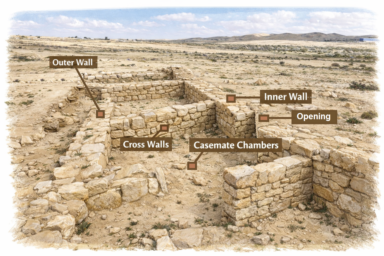
Illustration of casemate wall (Image created by AI using OpenAI’s ChatGPT)
Excavations near these fortresses have uncovered groups of dwellings, suggesting the sites served as hubs for larger communities. Interestingly, the pottery found at these locations tells a story of two distinct cultures:
- Wheel-made Pottery: Identical to shards found throughout Judah, dating to the United Monarchy.
- Negbite Ware: Crude, handmade pottery created by local nomadic groups.
- Who built these structures, and why?
The origin of these enclosures is one of the most contested topics in Levantine archaeology. Here are some concepts: (a) I. Finkelstein suggests that these weren’t fortresses, but sedentary structures built by Amalecites or the Tribe of Simeon, similar to modern Bedouin animal pens. (b) Y. Aharoni considered that they represent a gradual Israelite penetration into the Negev during the 11th century BC (Iron Age I). (c) Z. Meshel/R. Cohen suggested that these were administrative centers built by Saul or Solomon to protect the frontier against desert nomads.
- Destruction
It is likely that the sites were destroyed during the Egyptian invasion of Shishak (926 BC), who swept through the kingdom of Judah as reported by the Bible. After the split of the Unified Kingdom, Shishak invaded the land of Israel and captured Aroer as well as other fortified Judean cities. Shishak (also known as Sheshonk I) was an Egyptian pharaoh who ruled from 945-924 BC. He is known for his military campaigns in the Near East, including his invasion of Israel in 925 BC. The Bible wrote about this campaign (1 Kings 11:40; 14:25-26; 2 Chronicles 12:2-9). These verses are from 2 Chronicles 12:2-4:
“And it came to pass, that in the fifth year of king Rehoboam Shishak king of Egypt came up against Jerusalem, because they had transgressed against the LORD, With twelve hundred chariots, and threescore thousand horsemen: and the people were without number that came with him out of Egypt; the Lubims, the Sukkiims, and the Ethiopians. And he took the fenced cities which pertained to Judah, and came to Jerusalem”.
In this relief on the wall of the Great Temple at Karnak, the pharaoh listed the places he conquered in his campaign. The conquest of Tel Yeruham appears on a wall in his palace in Upper Egypt, and the name appears as Y-r-h-m.

Karnak: Commemoration of Shishak’s victory over Rehoboam
Photo of the Library of congress (American Colony, taken 1900-1920)
Sites:
The following table lists the sites that are featured in BibleWalks, and detailed below.
| Forts’s name | Forts Plan | Size | Route |
| Nahal Avnon, Yeruham | Central courtyard, casemate wall along peripheral | 30m x 55m (estimated) | “Way of the Sites” – Yeruham to Tel Arad |
| Horvat Ritma | Square fortress; large central courtyard surrounded by casemate rooms. | 21m x 21m | East-west route along Nahal HaBesor |
| Horvat Halukim | Oval-shaped fortress; 7 casemate rooms around a central courtyard. | 23m in diameter | “Way of the Sites” – Ramon to Yeruham |
| Mt. Eldad fort | Rectangular-trapezoidal shaped fort; 5 casemate chambers around an inner courtyard. | 14m x 18m. | “Way of the Sites” – Ramon to North and West |
| Ramat Boker | Triangle shaped, pointed towards North-North-West. | 31m/33m/28m | East-west route along Nahal HaBesor |
| Be’erotayim | Rectangular structure, a tower and residential rooms, | 22m x 24m. | “The way to Shur” – Beersheba to Kadesh-Barnea |
Overview of each site is listed below. Click on the site name to visit the page of the site.
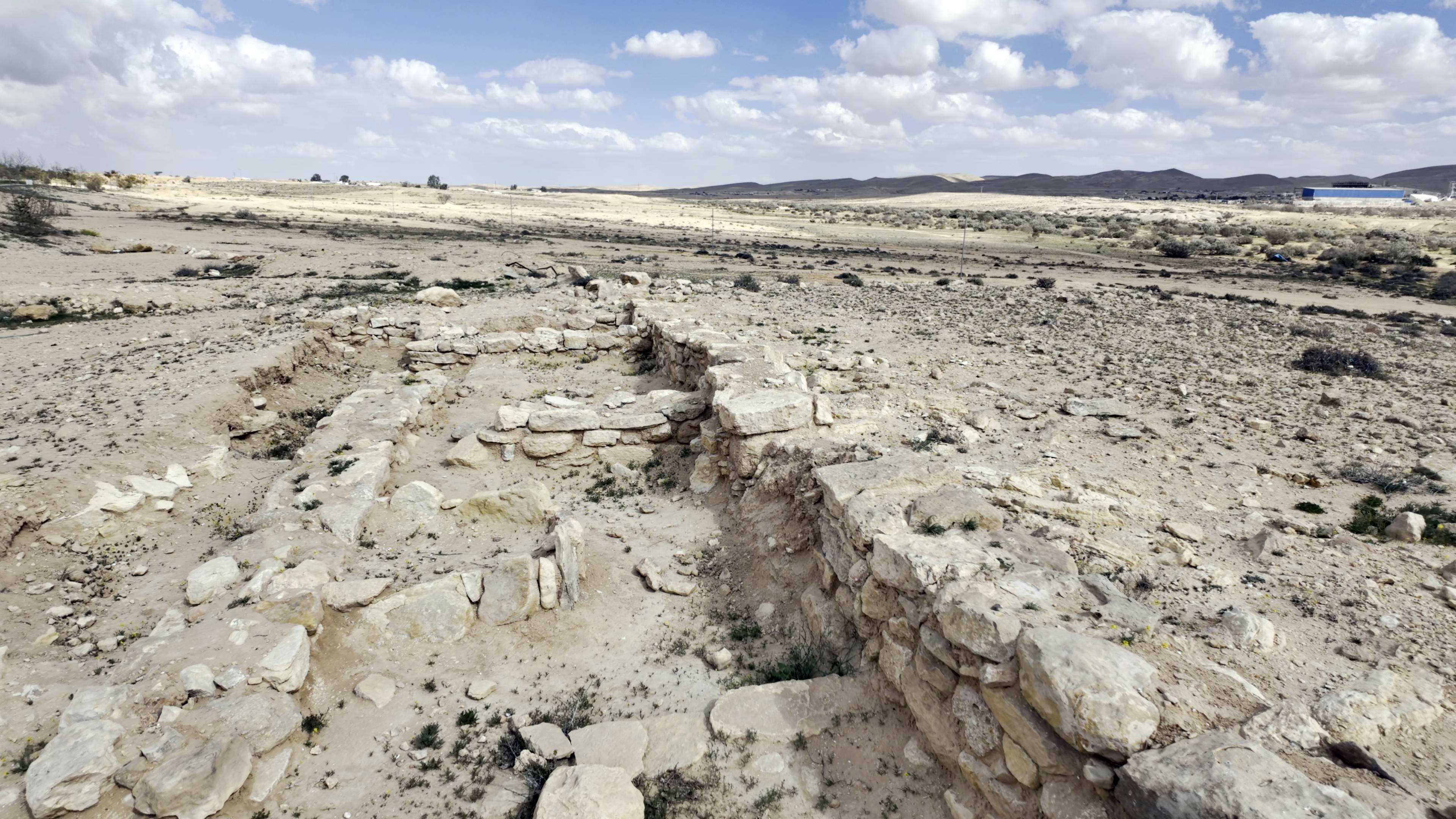
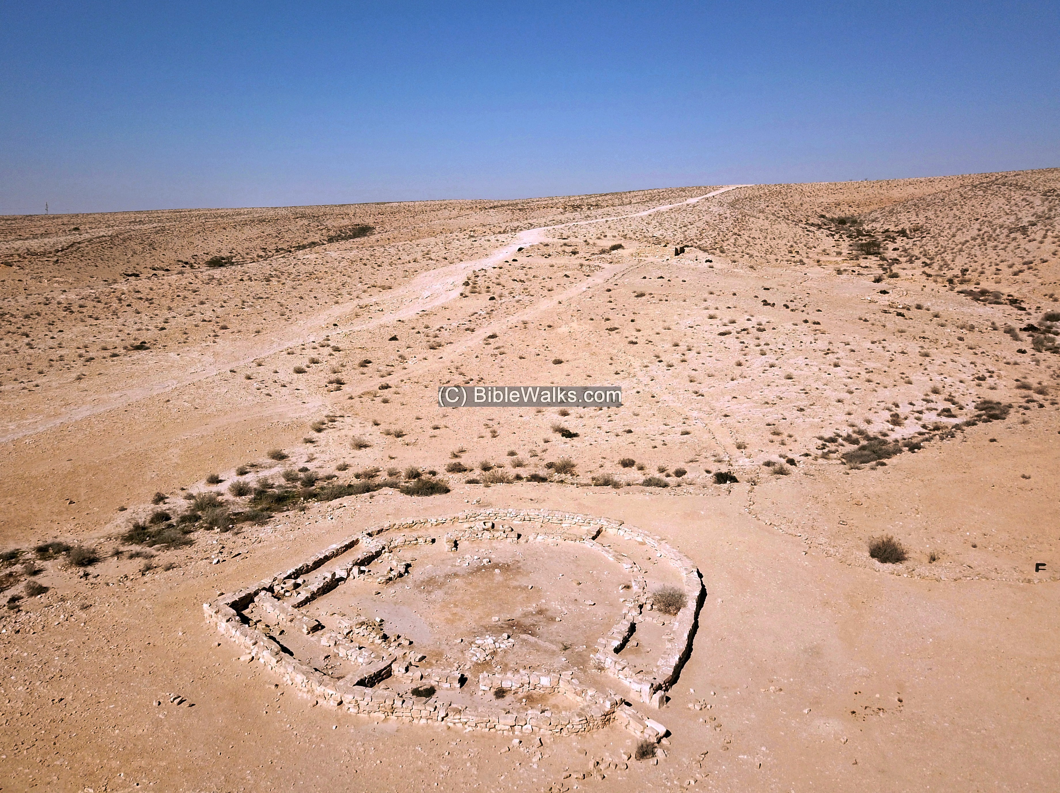
(a) North bank of Nahal Avnon, Yeruham
The fortress was built along the north bank of Nahal Avnon that crosses the modern city of Yeruham. This creek flows from Mt. Avnon, on the edge of the great crater, to Nahal Revivim, a source of Nahal HaBasor.
Recent excavations revealed the north east corner of the fortress, which incorporated a casemate wall. It covers roughly 30 by 55 meters (estimated) – one of the largest of the Negev fortreses.
(b) Horvat Ritma
Ruins of a Israelite IIa period desert fortress and small settlement, on the southern bank of Nahal Boker. It overlooked the vast valley, and guarded the ancient east-west desert route that passed along Nahal HaBesor.
The fortress is square – 21m x 21m. Its plan is a large central courtyard surrounded by casemate rooms.
The fortress was also occupied during the Persian and Nabatean periods.
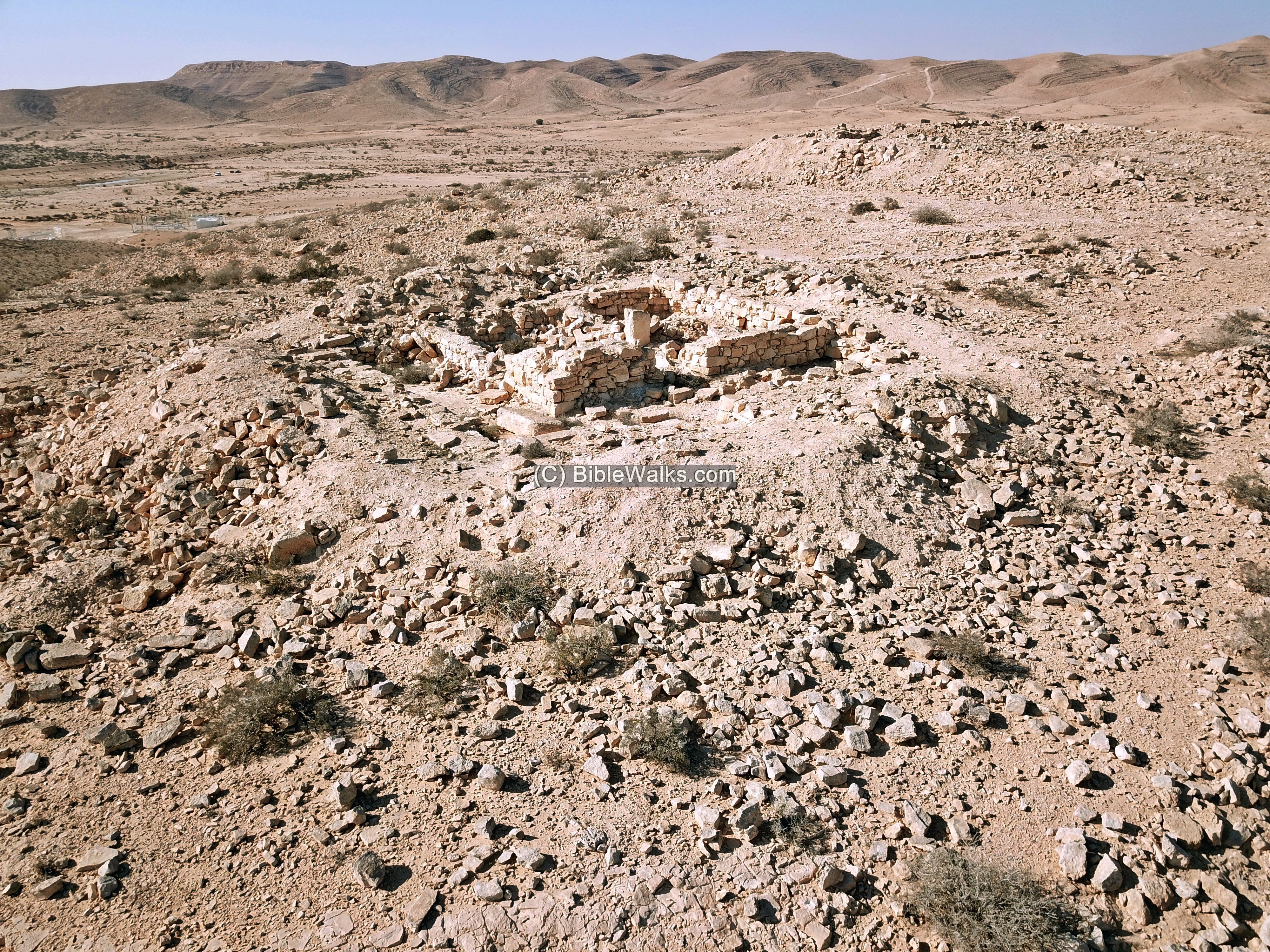
(c) Horvat Halukim
Ruins of an Israelite period (Iron age IIa) fortress and village. The village consists of 25 structures, built along 3 valleys of the HaRo’a stream.
The fortress is 23m in diameter, with 7 casemate rooms arranged around a central courtyard. The walls consist of limestone slabs.
The oval-shaped fortress was reused by the Nabateans during the Roman period.
(d) Mt. Eldad fort
This small Iron Age fort is located on a small rocky hill, on the North-West bank of Nahal Zin, 2km south of Avdat National Park. It guarded the ancient route from Makhtesh Ramon towards the north and west.
The rectangular-trapezoidal shaped fort covers an area of 14m by 18m. The fort consists of an entrance room on the south side, and 5 casemate chambers arranged around an inner courtyard.
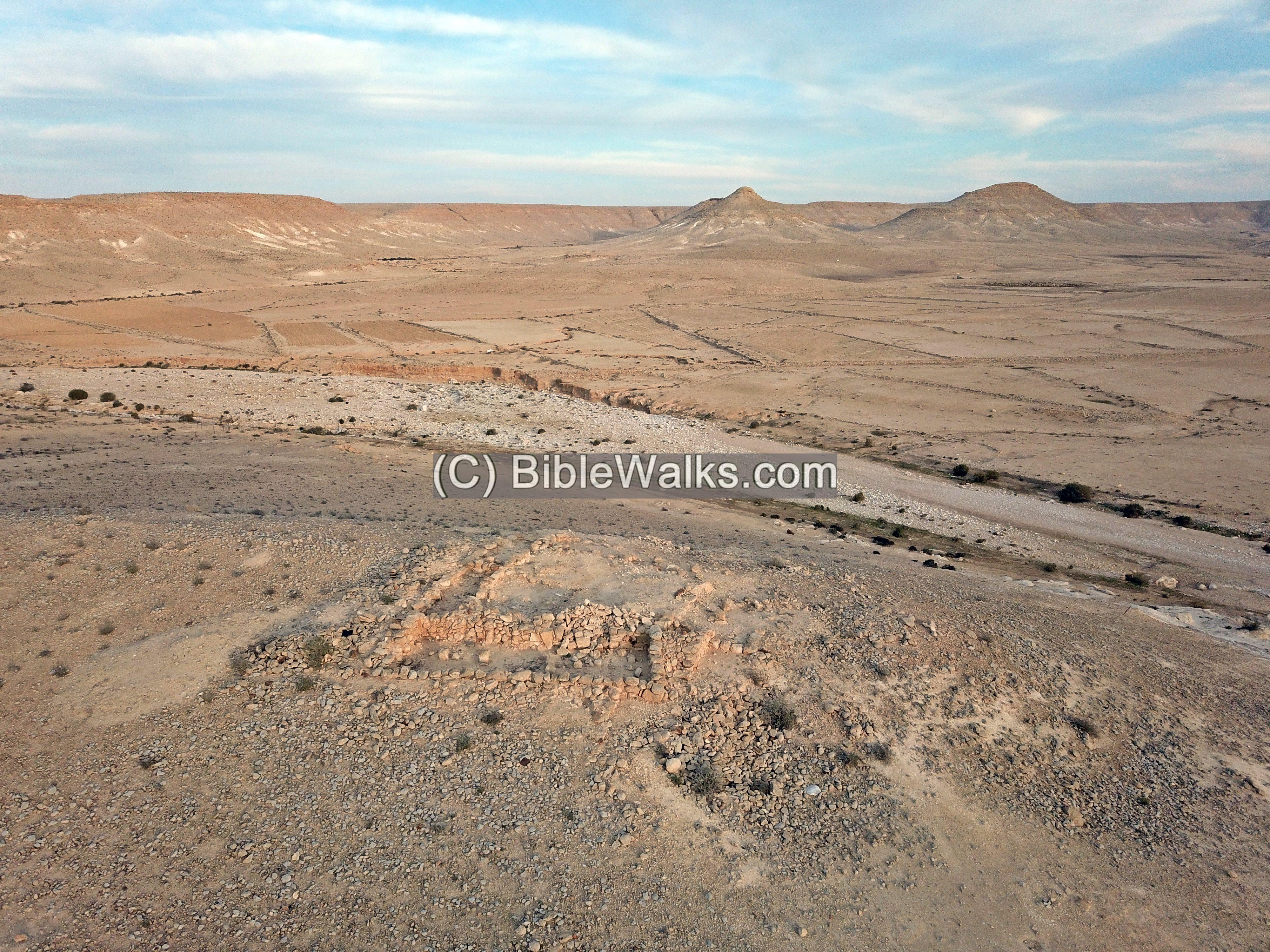
(e) Ramat Boker
On the south east ridge of Ramat Boker (also: Ramat Boqer), north of Nahal Boker valley, are ruins of an Iron Age fortress and houses. It guarded the ancient east-west desert route thru Nahal Besor.
The fortress was built on a natural hill and was planned according to its shape. It covers an irregular area, in a form of a triangle pointed towards North-North-West. The western edge is 31m long, the eastern 33m, and the southern edge is 28m long where the entrance was located. On the northern corner was a structure, built in a second phase, oriented with a shift to the northwest. An aerial view of the fortress, with a view towards the north, is seen below.
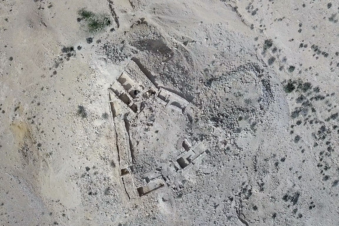
(6) Be’erotayim
A desert Oasis with two wells (named Moses and Aaron). A fortress was located along the western hill overlooking the ancient route, dated to the Iron Age IIa period (1000-925 BC). The fortress includes a rectangular structure, a tower and residential rooms, covering an area of approximately 22x 24m. It is identified by some scholars as Biblical Beeroth.
The route that passed here is Darb el-Shur ( “The way to Shur” – Beersheba to Kadesh-Barnea). This route is based on the Biblical name, described in the story of Hagar and Sara (Genesis 16: 7): “And the angel of the LORD found her by a fountain of water in the wilderness, by the fountain in the way to Shur.”
Etymology (behind the name):
* Names of the area:
- Yeruham – the town was established in 1951. The name is derived from the Hebrew root R-H-M (ר-ח-ם), means “mercy,” “compassion,” or “to cherish.” Before the modern town was founded, the area was known by the Arabic name Bir Rakhma, meaning “Well of Mercy.” It is located north east of the Lake’s park area. Local tradition identifies this ancient well as the one revealed by God to Hagar when she was wandering in the desert with her son Ishmael (Genesis 21)
- Tel Yeruham – – an Iron Age site on the west side of the town.
- Khirbet A-Rakhma – Arab name of Tel Yeruham, an ancient mound north of Yeruham. In Arabic: the ruins of mercy.
- Qasr Rekhmeh – the Arabic name of the site (means: fortress of mercy)
Links and References:
* External links:
* Internal links:
- Yeruham – overview of sites around the city
![]()
BibleWalks.com – Exploring the Negev Iron age fortresses
Hiding complexes<—previous Negev site—<<<All Sites>>>—next Negev site —> Moa
This page was last updated on Mar 18, 2026 (add Beerotayim, summary table)
Sponsored links: