Ruins of a Bronze/Iron Age and Roman/Byzantine settlement north west of Menahemiya.
Home > Sites > Jordan Valley> Horvat Melahat (Sheikh el-Muweilihat)
Contents:
Overview
Aerial Map
History
Photos
* Aerial Views
* Center
* North West
* North East
* Eastern Foothills
* Ceramics dating
* Nature
Videos
Etymology
Links
Background:
Horvat Melahat (Sheikh el-Muweilihat) is an archaeological site situated west of the modern village of Menahamia in the Jordan Valley. The site occupies the edge of a ridge that marks the mid-slope of the eastern ascent from the Jordan Valley. The area surrounding the site is dotted with several springs, likely crucial for sustaining ancient settlement. The ridge overlooks the northern bank of Wadi el-Jurum, whose Arabic name means “Valley of the Eroded Land.” This deep basalt canyon, known for its dramatic landscape, continues to attract hikers today.
On the summit of the ridge are the remains of about a dozen ancient structures, their foundations built from local basalt stones. These may have formed part of a small fortified outpost or observation point, guarding movement along the ridge and overseeing access to the valley below. Our surface survey conducted at the site have revealed pottery sherds from multiple periods, including the Bronze and Iron Ages, as well as the Roman and Byzantine periods—indicating intermittent or continued occupation over a long span of time.
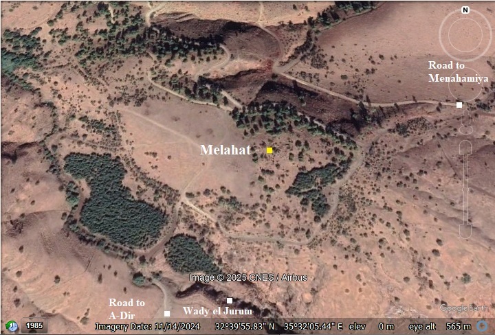
Map / Aerial View:
The aerial map below shows the area around the site, indicating the main points of interest. The site lies at 70m above sea level, approximately 260 meters above the Jordan valley floor. It is in the middle of the descent from the Sirin Heights, which are 300 meters above and west of the site.
History:
- Bronze/Iron (Biblical) Age
The site was settled in the Bronze and Iron ages. It was located near trade routes that descended to the Jordan valley, or ascended to the Sirin heights.
The cities and roads during the ancient periods, up to the Roman period, are indicated on the Biblical Map below. The site is marked as a red circle. The ancient west-east route is not indicated here.
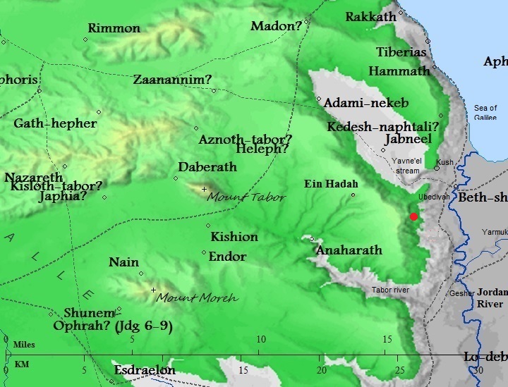
Map of the area – during the Canaanite and Israelite periods (based on Bible Mapper 3.0)
The strategic placement of Horvat Melahat is emphasized by its relation to a known ancient route that once traversed this landscape. According to David Dorsey (“The Roads and Highways of Ancient Israel,” 1991, p. 107), this path—designated as Route ‘T3a’—descended from the Sirin Heights via Mizpe Elot (Sheikh Muzeighit) and Horvat Melahat, continued past Khirbet el-Jurum near Menahamia, and ultimately reached the Jordan River crossing at Tel Ubeidiya. This route remained in use not only in antiquity but also during the Ottoman period, serving travelers and traders into the 19th century.
Another branch (‘T2’, p. 106), from Mt. Tabor, passing via Tel Ein Haddah, is another west-east Biblical route that passed near the site.
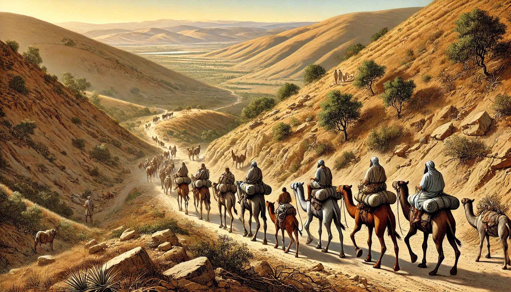
Caravan descending to the Jordan valley – AI generated by Stable Diffusion
The site was part of a network of fortified settlements or posts that were positioned by the Israelite northern kingdom at strategic locations along major roads:
- Horvat A-Dir, a similar Iron age fortress, is 1.5km south east of this site and on the side of the road that descends from this site.
- Horvat Kush, yet another Iron age fortress, is 2.5 km north east of this site. It also guarded an important route descending to the Jordan valley along the Yavne’el valley.
- Israelite period (House of Omri)
According to Finkelstein (“Omride Architecture in Moab: Jahaz and Ataroth”), these Iron age fortified settlements were constructed by the Omri House monarchs (Omri, Ahab, Ahaziah, Yoram, and Athaliah, who reigned during the years 885-835 BC). During these years, the arch enemy Aram-Damascus was probably the trigger to construct defense lines along the eastern frontier.
Omri was a general, who was made king (882 BC) over the Northern Kingdom during the mutiny of Zimri (1 kings 16 16): “And the people that were encamped heard say, Zimri hath conspired, and hath also slain the king: wherefore all Israel made Omri, the captain of the host, king over Israel that day in the camp.”. After regaining the control of his Kingdom, Omri turned to defend his country against their arch-enemy – Aram-Damascus – and the rising empire of Assyria.
Ahab, his son, fought against Aram-Damascus in 3 battles, but was killed (850) in the 3rd battle. Ahab’s son Yoram continued to confront the Syrians, and was killed in Jezreel (842), thus ending the house of Omri. (1 kings 22:35): “And the battle increased that day: and the king was stayed up in his chariot against the Syrians, and died at even: and the blood ran out of the wound into the midst of the chariot”.
The assaults continued from the north: the Assyrians forces – a rising force in the region- hit the Northern Kingdom in 841, and Aram-Damascus headed by Hazael invaded in 815-810, as per Biblical accounts (2 Kings 8:12, 12:18-19, 13:3+7; Amos 1:3) and (2 Kings 10 32): “In those days the LORD began to cut Israel short: and Hazael smote them in all the coasts of Israel;”. In one of these intrusions the city of Rechov, the major city in this region, was violently destroyed. The archaeologists dated this destruction to an approximate date 840-830BC. This was probably the fate of the other Iron Age forts in this area.
- Roman/Byzantine period
The site was resettled during this time. Most of the structures seen on the hilltop are from that period.
-
Ottoman period
The area was examined in the PEF survey (1866-1877) by Wilson, Conder and Kitchener. A section of their map is seen here. The site is not indicated on the map, but we marked it as a red dot . A road is shown connecting the village of El Hadetheh (Bronze/Iron age Tel Ein Haddah) to nearby Mizpe Elot (esh Sheikh Muzeighit), but probably it descended thru Melahat and a-Dir. Another road descended from Sirin, passed near the site, and down to the Jordan valley.
The report did not review the site.
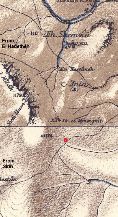
Part of Map sheets 6 & 9 of Survey of Western Palestine,
by Conder and Kitchener, 1872-1877.
(Published 1880, reprinted by LifeintheHolyLand.com)
-
British Mandate – Map:
A section of the 1940s British map shows the area around the site, which is seen as a dotted recnagle (and we marked it in red color). Notice that there is a route (a dashed line) that descends from the Sirin heights thru the site, passing Mizpe Elot (Esh Sheikh Muzeighit), and continues down the foothill thru Kh. ed Deir. These sites were settled during the Bronze/Iron age periods as well as Byzantine period, so they are a chain of settelemnst and fortified stations along this important trade route..
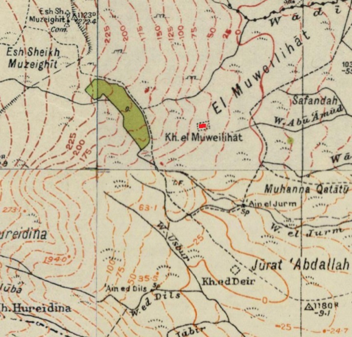
British survey map 1942-1948 – https://palopenmaps.org topo maps
License: public domain under the UK Copyright, Designs and Patent Act 1998
- Modern Period
The site was not yet thoroughly researched. During our visits to the site we attempted to understand its structure and history.
Photos:
(a) Aerial views
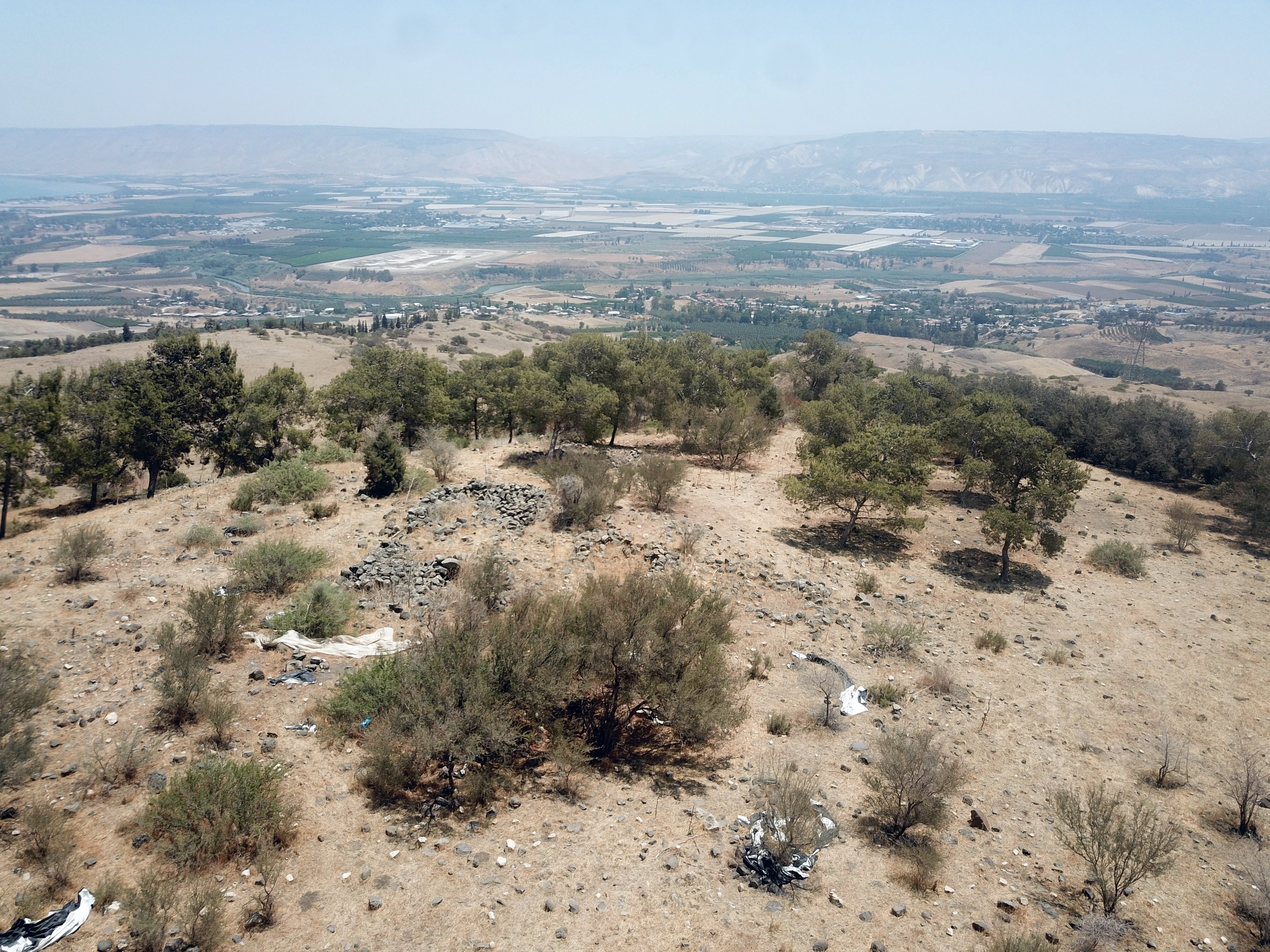
A drone view captured this eastern view towards the Jordan valley. Ruins of structures, made of rough basalt stones, are scattered on the peak of this hill.
Click on the photos to view in higher resolution…
(b) Structure in the center
In the center of the site, on the summit of the hill, are several of the ruined structures. The structures are small, just a few meters in length, and made of rough basalt stones.
This one is the largest seen on the site.
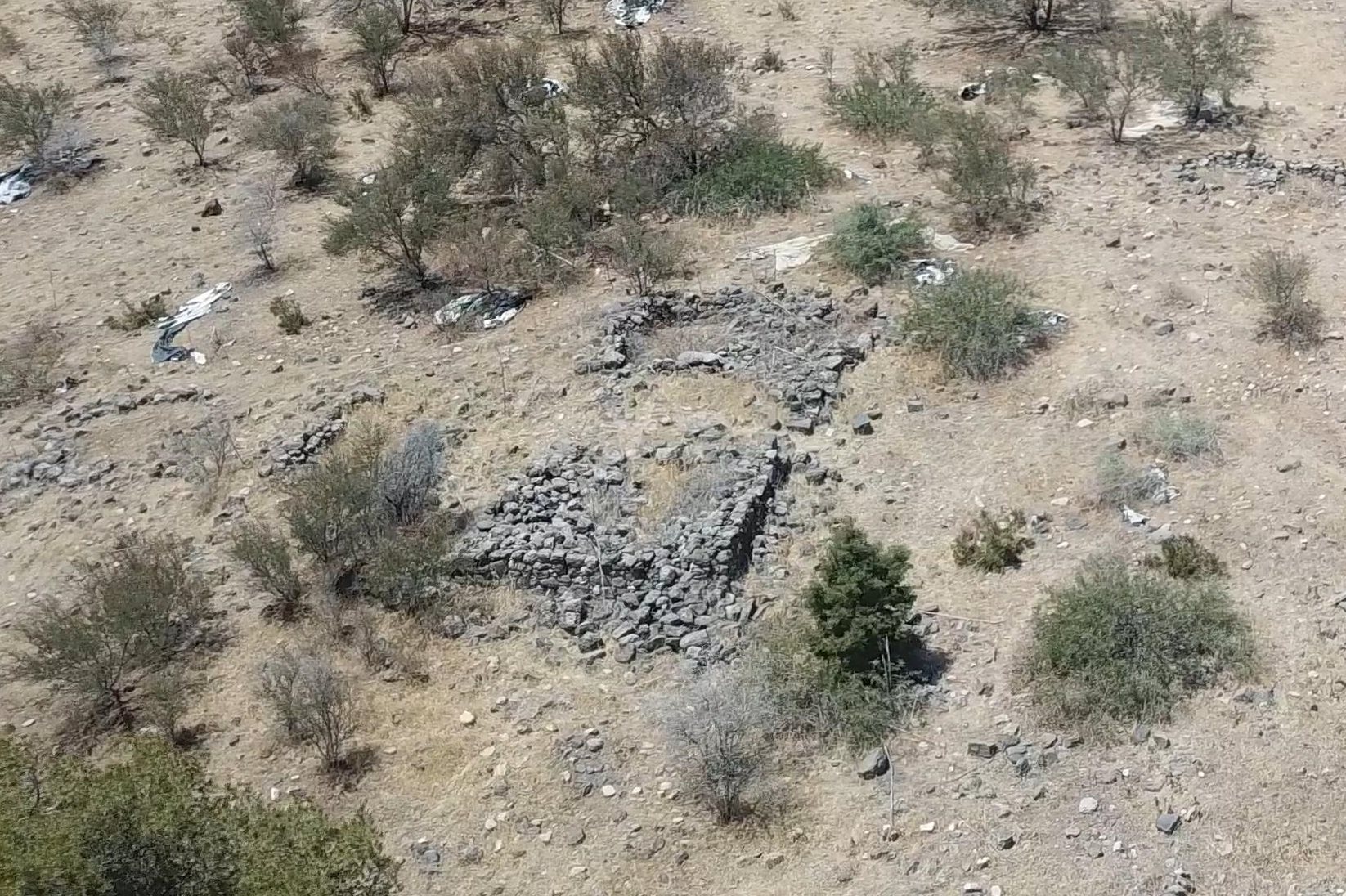
Next is a view from above.
This rectangular house has two rooms, an open courtyard between them, with an entrance thru the courtyard on its north side. Smaller structures on the south side are detached from the main structure. This plan seems is typical of the Byzantine period.
The same structure is seen below, captured from the ground level on its north west side.
Note that the archaeological scale bar, placed at the side of the structure, has white and black bars 10cm wide.
The northern wall is better preserved, standing several courses high.
This is the same side, but captured during the winter.
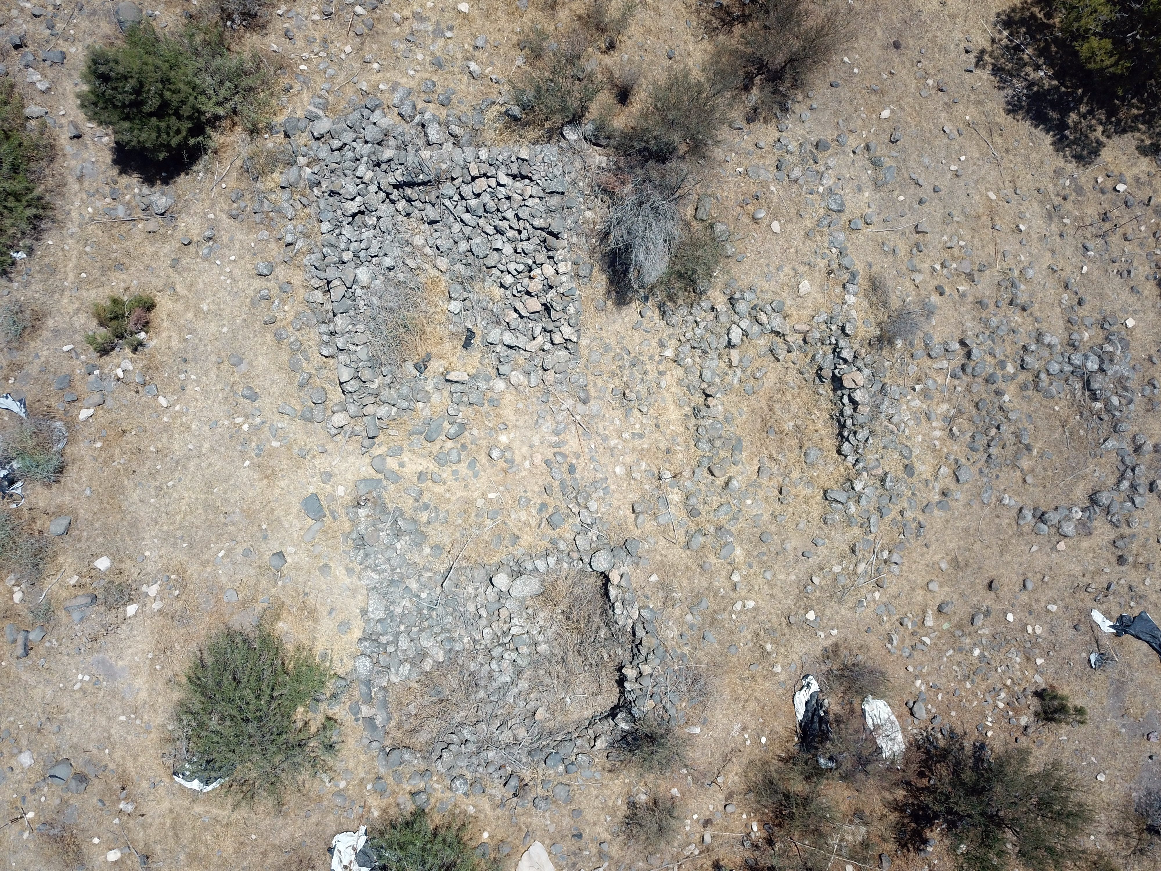
(c) Stucture on the North West side
Another similar ruin is on the north west corner of the site.
Next is a view of the structure from above.
It also has a rectangular plan with two rooms, an open courtyard between them, and smaller walls in the open area behind.
(d) Stucture on the North-East foothill
Another structure was built along the north-east foothill.
Entrance to the structure is on its south side.
From this structure are great views of the Sea of Galilee and the Jordan valley on its south side.
A closer view of the area. The Levy Eshkol memorial and observation point is located on the top of the hill in front of the view of the lake.
We also photo’ed this structure during our winter visit:
(e) Structure on the Eastern foothill
On the eastern foothill is another structure, with several sections covering a large area.
A section in the middle of this complex is rectangular, with a size of about 5m in length and 2.5m in width. It is divided by an internal wall, as seen in this aerial view.
(f) Pottery Dating
Pottery sherds we collected for dating purposes indicate that the settlement was occupied during the Bronze and Iron Ages, as well as Roman and Byzantine periods.
A sample of pottery sherds are seen below, with Byzantine period on the left and Roman period on the right.
We also dated Bronze and Iron age period sherds:
(g) Nature photos
A turtle was seen in the site:

A closer view of the shy turtle:

Videos:
![]() This video summarizes a field survey of the site by BibleWalks staff, conducted on July 2025. Remains of the surrounding walls were observed during the survey, and pottery sherds were dated. The survey was captured on video and posted as a YouTube video:
This video summarizes a field survey of the site by BibleWalks staff, conducted on July 2025. Remains of the surrounding walls were observed during the survey, and pottery sherds were dated. The survey was captured on video and posted as a YouTube video:
Etymology – behind the name:
* The name of the site:
- Kh. El Muweilihat – as appear on British map.The name “al‑Muweilihat” (الموييلات) appears to derive from the Arabic root w‑l‑h, commonly used in words that signify beauty, radiance, or sheen (e.g. muweel from jameel, meaning “beautiful”). The feminine plural or diminutive form (‑‑ihat) may signify “the little radiant [ones]” or “the charming/well‑shaped ones”.Alternatively, it could be a tribal or family name referencing dwellers or landowners, but in the landscape context it likely refers to a scenic or renowned place.
- Horvat Melahat – Hebrew name, based on the Arabic name
- Sh. el Mezcighit – as appears on PEF map, but could be another site (Mizpe Elot). The PEF suggests the private name means ‘angry’.
* Other names in this area:
- Wadi el-Jurum – Arabic: “Valley of the Eroded Land.”
Links and references:
* References:
* External links:
* Internal links:
-
- Horvat Ziwan – A similar Iron age fortress, south of this site
- Horvat Kush, another similar Iron age fortress, is 2.5km north east of this site.
- Horvat A-Dir – another similar Iron age fortress, is 2.5km south east of this site.
- Mizpe Elot – another Iron age site on a higher ground
- Jordan valley survey – by BibleWalks team
BibleWalks.com – walks along the Jordan river
Mizpe Elot<<<—previous Jordan Valley site—<<<All Sites>>>—next site—>>>Horvat Anin
This page was last updated on Nov 18, 2025 (new page)
Sponsored Links: