In the vicinity of Kfar Ruppin is a cluster of Biblical sites, located near a major crossing point of the Jordan river.
Home > Sites > Jordan Valley > Kfar Ruppin ford crossing (overview)
Contents:
Background
Location
History
River Crossing
Geology
Photos
* Artal
* Karpas
* Karpas north
* Horvat Dveka
* Halashon
* Zarom
* Tel Kataf
* Masad
* Hasut
Etymology
Links
Background:
Many sites surround a a major crossing point across the Jordan River, known as Makhadet esh Sheikh Daoud (Ford of Sheikh David). This overview page describes river crossing and the high concentration of Biblical sites in the vicinity of Kfar Ruppin.
(Joshua 2:7): “And the men pursued after them the way to Jordan unto the fords…”.
Location:
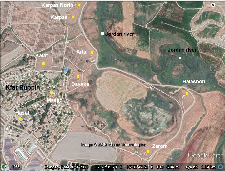
The ancient sites are located within a 1km radius around Kibbutz Kfar Ruppin. The 9 sites are indicated by yellow squares. In antiquity this was a major crossing point of the Jordan river through the ford at this area.
History:
-
Biblical map
The cities and roads during the Canaanite and Israelite periods are indicated on the Biblical Map below, with the crossing point marked by a red dot on the west bank of the Jordan river.
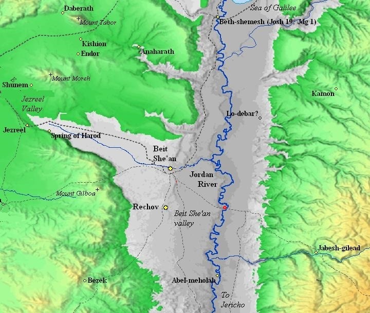
Map of the area around Kfar Ruppin – during the Canaanite and Israelite periods (based on Bible Mapper 3.0)
David Dorsey (“The roads and Highways of Ancient Israel”, 2018, pp.111-112) suggested that a east going highway (marked T7c), connecting Jezreel and Beit She’an thru the fords near Tel Artal, was the major route used to cross the Jordan river. This route is marked in the map as a dashed line that crosses the Jordan river, passing near the red dot. The main river crossing was named Makhadet esh Sheikh Daud (ford of Sheikh David). It is near several Bronze/Iron age sites in the vicinity of Kefar Ruppin. The highway connected on the other side of the Jordan river to the city of Pehel (Pella), and was the main crossing point in this region. It continued to the Transjordan highlands and on to Damascus and beyond.
- Roman period
An ancient Roman highway (from Scythopolis/BethShean to Pella/Pehel) passed on the north side of Tel Artal. It probably traced the route of Nahal Hobari that flows between Tel Karpas and Tel ‘Artal.
A group of 5 Roman milestones were found during the PEF SWP survey in Umm el-‘Amdan (K. Ruppin map 67, site 86). The PEF survey wrote about this find (Vol 2 p. 130): “Several fragments of rude pillars, lying in the water by the road. They seem probably to be Roman milestones”. Their location was 1.5km NE of Tel ‘Artal, and 5.8km from Scythopolis, on the north bank of Nahal Hobari. Two of the milestones marked the 4th mile from Scythopolis to Pella, which is the distance where they were found (5.8km = 4 Roman miles). The group of milestones were transferred to Gadash Gilad shed.
-
Ottoman period
Edward Robinson, the “father” of Biblical Geography, crossed the ford on his travels in 1852, arriving from the east bank (E. Robinson, published 1857, “Biblical researches in Palestine, and in the adjacent regions”, p. 325):
“…Another ford is considerably further up the stream. We now turned down the river about S. S. W. and came in fifteen minutes to the lower ford, called Tumra, at 3.35. A low Tell and Wely are on the opposite side, a third of a mile below, called Sheikh Daud.’ The same guide again waded through, and gave a favorable report. The two Sheikhs rode through first ; the current was strong, and the water came up high on the horses’ sides, and to the tops of their tails behind. We now made our arrangements for crossing, as in the morning. Sheikh Kasim, who had shown himself by far the most courteous and obliging, proposed to wade and lead our horses through one by one. To this we gladly assented ; and so came safely over, with a slight wetting of some of the saddlebags, but without injury to anything. — The ford, both here and above, lay across a bar in the stream, on the brow of a rapid, as in the morning. The river was deeper and broader, measuring one hundred and forty feet in width.’ We started again at 4.05 ; and at 4.10 reached the top of the high bank of the lower valley.'”
The site was examined in the PEF survey (1866-1877) by Wilson, Conder and Kitchener. The surveyors assumed that the main mound in this area – Tel Artal (Tell esh Sheikh Daud) – was a natural hill. They ignored the other Tels around it. Their survey report was short (Vol 2, p. 128):
“Tell esh Sheikh Daud—Possibly a natural mound; a ruined Mukam of modern masonry exists near it”.
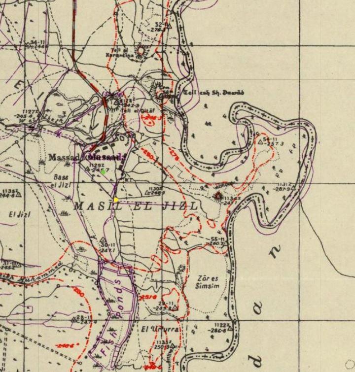
A section of their map is shown here. Notice the serpentine shape of the river at this point.
The river crossing (marked as Mak.t – short for Makhadet – Arabic for ‘ford’) appears as a line south east of the Tel. The map shows a large number of fords that were used for the river crossing, also marked as Mak.t. A road, leading to the river crossing, appears at the south side of the hill. This may have been the route of the Roman period road and during the previous periods.
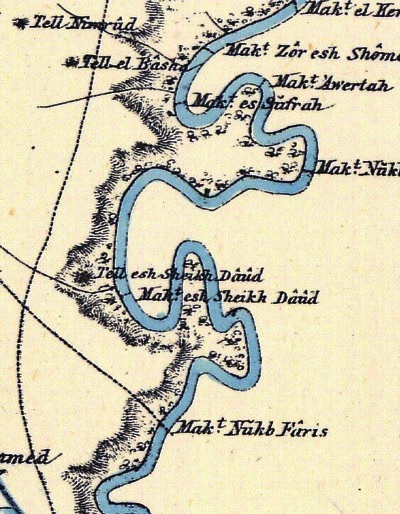
Part of Map sheet 9 of Survey of Western Palestine,
by Conder and Kitchener, 1872-1877.
(Published 1880, reprinted by LifeintheHolyLand.com)
- British Mandate
A 1940s British map shows the area around the site with more details. The site is marked here as “Tell esh Sh. Daoud”. The Jordan river passes on the eastern side of the map. Its course changed a bit (moved slightly east) as marked by the purple colored parallel lines that were drawn as corrections.
A number of other Tels (6) are marked around it. The number of ancient sites in this small area indicate the importance of the area during the antiquity. This is one of the most highly concentrated areas with Bronze/Iron Age ruins.
British survey map 1942-1948 – https://palopenmaps.org topo maps
License: public domain under the UK Copyright, Designs and Patent Act 1998
A 1922 archaeological survey reported:
“Tell Esh Sheikh Daoud – Only one tell is marked on the map and that not the most important. Actually there are not less than six grouped together, the largest lying to the South of that marked on the map and having on the top several Moslem graves. Right on the summit is a trigonmetrical station for the new survey, which is marked by a beacon. The other four tells lie to the West and South of this and one of them has an occupied Arab house upon it. This settlement was evidently one of great importance” Visited 27.5.1922″.
The surveyors added:
“Due East of Sheikh Daoud a tongue of high ground runs North into a Loop of the Jordan, On this are two tells one on the tip and the other at the root. Little pottery was seen on the former and its possibly natural. Neither is marked on the map. Visited 27.5.1922”.
Note that we wrote these lines exactly 100 years later on 27.5.2022!
In 1938 a Kibbutz, Kfar Ruppin, was founded on nearby Tel Massad.
In May 1939 the British army requested to build a pillbox fort on the hill, but the archaeological inspector denied this request unless it was approved by the director of Antiquities. It was not…
A survey in 1942 mentioned that there are some graves on the top.
A later survey in 1946 provided additional details:
“A high artificial mound, moderate size. It is prolonged in shape running parallel to Jordan river (N-S). Potsherds of Bronze Age and later on … on surface. The Jordan river to E is fordable in two places. It lies nearly half was between Scythopolis and Pella (Tabaqat Fahl). It is most probable that the Roman road passed nearby. To the W. there is a flat mound, artificial appearance, called Tell el Qatif. Another small mound is standing to N.W… Condition: the site has not been cultivated. – RWH 9.1.46.”
-
Modern Times
The Tels are accessible by car from Kefar Ruppin. However, a section of the road is not permitted for entrance since it is on the Jordanian border. The restricted section is marked by signs.
River crossing in antiquity
In the antiquity the Jordan river crossings was by crossing fords along the river rather than using bridges or ferries. Bridges were constructed only during the Roman and Mameluke periods. Dorsey (“The roads and Highways of Ancient Israel”) claims that no Bronze or Iron Age bridges were found along the Jordan, and the Bible does not mention such bridges.
Same goes to ferries – there is no evidence of Biblical period ferries. The Madaba map depicts a rope ferry crossing, but that was illustrated during the Byzantine period (6th century AD), 1000 years later than the Iron Age.
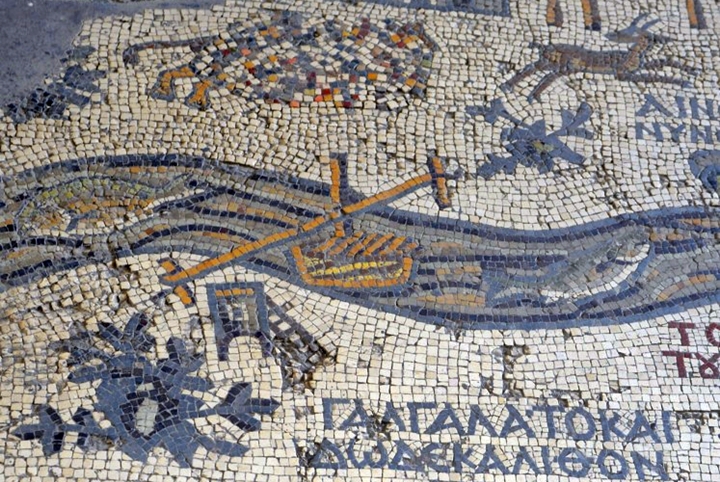
Jordan river rope ferry crossing – p/o Madaba map – 6th century AD
During the antiquity the Jordan river was more powerful and harder to cross, so trade routes connecting the west to east had to select the most convenient location for the crossings. This changed in modern times, as the source of the Jordan river was blocked in 1932 by the Degania dam on the south side of the Sea of Galilee, and the river turned into a slow flowing creek.
According to an article by David Moster, in the Biblical period it was easier to cross the Jordan river to the north of the Zarqa (Jabbok) river (near Argaman) rather than to the south of it. The North, with 41 fords, had less water and a narrow valley to cross. The south, with a deeper and more difficult crossing, had only five fords. According to report of W. F. Lynch (1847), the river expanded from 160 feet and 2.5 feet deep at the Sea of Galilee, to 120 ft wide and 6 feet deep at the Yarmouk river, farther south to 120 feet wide and 7 feet deep at the Zarka river midway, and up to 240 feet wide 7 feet deep in the Dead Sea – a 410% increase in river flow from North to South.
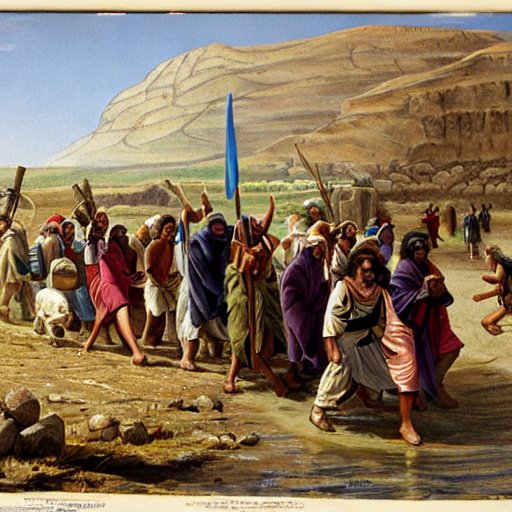
Crossing a ford on the Jordan river – AI generated by Stable Diffusion
The Jordan river crossings appears at least 60 times in the Bible. The noun “Ford” appears 11 times. Example (Joshua 2:7):
“And the men pursued after them the way to Jordan unto the fords: and as soon as they which pursued after them were gone out, they shut the gate.”
(Joshua 7:7):
“And Joshua said, Alas, O Lord God, wherefore hast thou at all brought this people over Jordan, to deliver us into the hand of the Amorites, to destroy us? would to God we had been content, and dwelt on the other side Jordan!”
(Genesis 32: 22):
“And he rose up that night, and took his two wives, and his two women servants, and his eleven sons, and passed over the ford Jabbok“.
In external sources, one of the letters in papyrus Anastasi, probably dated to the times of Rameses II (1279-1213 BC), described the path a chariot would take from Megiddo to Syria via the Jordan valley. A section of this Late Bronze letter refers to the ford crossings near Beit She’an, Tarqa-El (an unkown city close to Beit She’an), and Rechov (as per Rainey & Notely 2006:102):
“…let me know Rehov [Ra-ha-bu], explain to me Beth-shan [Bi-y-ta-sa-‘a-[al]] and Tarqa-El [Ta-ra-qa-‘i-l]. As for the fords of Jordan [Ya-ar-du-na] how is it crossed? Let me know the route passing Megiddo [Ma-k-ta], which is on it”.
The crossing was harder during the winter time, and so only selected fords were used. The ford near Tel Artal is probably one of the major crossing points, as indicated by the number of Tels that are found here surrounding the ford.
Topography and Geology:
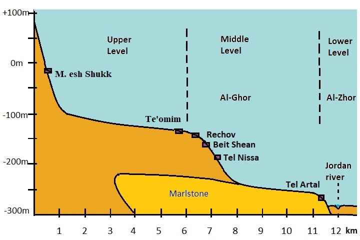
The Western side of the Jordan valley can be divided to 3 levels in the area of Beit Shean valley:
- Lower level known as Al-Zhor (‘הזור’, Ge’on Hayarden), 270m to 300m below sea level, 1km wide;
- Middle level known as Al-Ghor (‘הע’ור’, Kikar Hayarden, the depression), ~200m under sea level, 5km wide;
- Upper level (~100m below sea level), ~5km wide.
Tel Artal, as the other Tels in Kfar Ruppin, is located on the Al-Ghor middle level, next to the lowest level (Al-Zhor, -275m). The geological composition of Al-Ghor includes marlstone on the western side. On the Al-Zhor level it consists of Alluvium – silt that was eroded from mountains, and deposited by the river’s running water.
Photos:
Archaeologist Ayelet Goldberg-Keidar led our short survey of the sites. Here are results of our visits to the 9 sites around Kfar Ruppin.
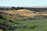
(a) Tel ‘Artal
Tel Artal (Tell esh-Sheikh Daoud) is seen in the following view from the north side. This steep artificial hill rises above the area, surrounded by water from three sides – Jordan river on the east side and streams Masil el- Jizl and Hobari on the north side.
Flintstones collected here were dated to the Upper Paleolithic and Chalcolithic period.
Ceramics collected on the mound and on its foothills were dated to the Early Bronze (many), Intermediate Bronze, Mid Bronze II, Late Bronze (many), Iron I, Iron II (many), Persian, Hellenistic, Roman, Byzantine, Early Muslim, and Mameluke.
![]() Read more on Tel ‘Artal.
Read more on Tel ‘Artal.
Click on the photos to view in higher resolution…
(b) Tel Karpas
Tel Karpas (Tell el-Karantina) is a larger mound, 7 dunams in area, located on the north bank of Nahal Hobari, 300m north-north-west of Tel ‘Artal.
Flintstones collected here were dated to the Neolithic or Chalcolithic period.
Ceramics collected on the mound and on its foothills were dated to the Early Bronze, Intermediate Bronze, Mid Bronze II, Late Bronze (few), Iron I (few), Iron II (few), Persian, Hellenistic, Roman, Byzantine (few) and Early Muslim. An Egyptian Middle Kingdom scarab was found on the tell.
The Arabic name of the site – Tell el-Karantine – was named after an adjacent animal quarantine station to its north.
The Hebrew name of the site – Tel Karpas – is named after the wild herb named Karpas Reihani (“engl celery”, Apium graveolens) that grows inside and at the edge of shallow waters. Celery, a common name for cultivated Karpas, is one of the traditional rituals in the Passover Seder.
Reference: Tel Karpas IAA survey, map 67, site #83 , Tzori 1962, site #52
The site was damaged by military works. An observation point was constructed on its summit with an orientation map.
From the observation point are great views of the Jordan river ford at the eastern foothills of the site. This was the crossing point over the shallow and narrow flowing creek. In the background are Jordanian villages and mountains.
(c) Tel Karpas North
Another site was surveyed on the north side of Tel Karpas – named Tel Karpas North. Its area is 2 dunams.
Ceramics collected along the ridge were dated to the Intermediate Bronze (most of the sherds) and Hellenistic period.
This settlement was part of the Intermediate Bronze age settlement that stretched along the western bank of the Jordan river.
Reference: Tel Karpas North, IAA survey, map 67, site #84 , Tzori 1962, site #52
(d) Horvat Daveka
The Jordan river loops around, flowing from the side of Tel Artal towards the east. A small lake formed inside the loop.
Another ancient mound is on the west side of this lake, adjacent to Tel Artal from the south. This is a Horvat Daveka. Its Arabic name is el-Karm, meaning “the ridge”. Its area is 8 dunams.
This north view was captured from the summit of Tel ‘Artal.
The site is covered on three sides with the al-zhor escarpment. The swimming pool of Kfar Ruppin is located on the western edge of the mound.
Reference: Horvat Daveka IAA survey site #79
The following is view of Horvat Daveka from the east, beyond the flow of the Jordan river.

Ceramics were dated by earlier surveys to the Early Bronze Age I, Intermediate Bronze, Mid Bronze II, Late Bronze, Iron I, Iron II, Hellenistic, Roman, Byzantine and Early Muslim.
A sample of ceramics we found on the Tel are shown here. All items were returned to their original location.
a. Handle, dated Iron Age II (10th-9th century BC)
b. Handle, Iron Age II
Excavations revealed tombs from the Early Bronze I age, Iron Age I and II and Roman period.
One of the findings included a seal bearing the name of the 13th century BC pharaoh Thutmose III.
(e) Halashon
Another surveyed area is a collective of small mounds on the east side. This is the area of Halashon (Hebrew meaning: the tongue) along the course of the river.
The area of the sites covers an area of 250 dunams. Sherds, collected on the top of small mounds, dated to Iron Age and late Roman/Byzantine period.
Reference: Halashon IAA survey site #94,Tzori 1962 site 60.
Yet another view from the north west:
(f) Horvat Zarom
Horvat Zarom is a small hill on the east side of the lake. It covers an area of 2 dunams.
Ceramics were dated to Early Bronze 1, Middle Bronze 2, Late Bronze, Iron 1 and 2 and Byzantine periods. A fenestrated incense burner, decorated with a snake pattern, was found here.
Reference: Horvat Zarom IAA survey, map 67, site #76, Tzori 1962, site #59
From the hill is a great view of the Jordan valley and the Jordanian villages across the river.
(g) Tel Kataf
Tel Kataf (Tell el-Qitaf) is a multi-period mound, on the north west side of Kfar Ruppin. The site is located on the south bank of Nahal Avuka (Masil el-Jizl) that flows into the Jordan river on the north side of Tel ‘Artal.

This low and flat mound covers a large area of 25 dunams. It was severely damaged by military works in the center of the mound.
An aerial view was captured in 2024 above the site (credit: Ayelet Goldberg-Keidar). It is oriented towards the south.
Ceramics were dated by earlier surveys to the Early Bronze Age, Intermediate Bronze age, Mid Bronze II, Late Bronze, Iron I, Iron II, Hellenistic, Byzantine, Umayyad, Crusader, Ayyubid and Mameluke.
Reference: Tel Qataf IAA survey, map 67, site #80, Tzori 1962, site #55
Samples of sherds we found around the foothills:
1. Bottom of a vessel
2. A handle with Potter’s Mark, Iron Age
3. Handle, Iron Age
4. A Muslim colored sherd
(h) Tel Massad
In the center of Kibbutz Ruppin was another multi-period mound – Tel Massad. Its Arabic name was: Kh. el-Hajj Mahmud, named after this Sheikh’s tomb which was once located on the hill. Its covers an area of 12 dunam.
Pottery sherds were dated to the Early Bronze Age I, Intermediate Bronze Age, Middle Bronze Age II, Late Bronze Age, Iron Age II, Hellenistic, Byzantine, Umayyad and Mamluke. On its eastern side were remains of a large colonnaded building of the Byzantine period, which was in use also during the Umayyad period.
Reference: Tel Masad IAA survey, map 67, site #78 , Tzori 1962, site #57
On November 28, 1938 a group established Kibbutz Ruppin on the site. This water tower was erected on top of Tel Masad.
On the foothills of Tel Masad is an open air museum, with a collection of antiquities that were collected on the site and in the vicinity.
The museum includes agriculture installations and instruments, bases and columns, milestones and other findings.
(i) Horvat Hasut
A small Tel, 0.5 dunam in area, is located on the south west side of kibbutz Ruppin. Pottery sherds and flint stones were dated to the Neolithic, Chalcolithic, Intermediate Bronze Age, Middle Bronze Age II, Iron Age, Hellenistic, Byzantine and Umayyad.
Reference: H. Hasut IAA survey, map 67, site #77 , Tzori 1962, site #58
Etymology (behind the name):
- Tel (Tell) – mound (See more on the story of a Tel).
- Makhadet – Arabic: Ford
- Makhadet esh Sheikh Daoud – Ford of Sheikh David
Links:
* External, archaeological links:
- British Mandate survey report
- IAA survey, map 67 – Kfar Ruppin sites
- N. Tzori 1962
- Crossing the Jordan river during the Biblical period – north versus south – David Moster, Aram 29 (2017), pdf
- Late Bronze Survey in Jordan valley – James Mark Schaaf (545 pages, 2012, thesis, Univ S. Africa); great resource!
- Bergman & Brandsteter Arch. surveys in Beit She’an valley (1940-1941:86-90, Hebrew)
- Survey of Tel Rechov area – Ahia Cohen-Tavor , 2010, Hebrew Univ, Hebrew
- The ‘bathtub coffin’ from Tel Qitaf – Laura Mazow 2014, Palestine Exploration Quarterly 146(1):31-39
* External, other links:
- Arrow of Peace – monument by Danny Zayit on Tel Artal
- Kfar Ruppin page – in bird watching site
- Biblical pictures by Gustave Doré (1832-1883) – public domain
- Wild flowers of Israel – ‘Artal flower (Hebrew)
* Internal links:
Other river crossing sites:
BibleWalks.com – exploring the ancient sites of Israel
Tel. ‘Artal<<<—previous site—<<< All Sites>>> — Next site—>>> Tell Abu Sus and Sakut
This page was last updated on Sep 6, 2025 (add Robinson)
Sponsored links: