This page describes the ancient roads to Jerusalem.
“All roads lead to Jerusalem.”
Home > Sites > Jerusalem > Roman Roads
Contents:
Overview
History
Peutinger Map
Sites of Roman Roads
Biblical refs
Etymology
Links
Overview:
Jerusalem is located in the center of Israel, on top of the Judean mountains (700-800M above sea level). For the past 3000 years it is one of the most important cities in the region, and required good roads to support the travel to all parts of the land. The travelers included pilgrims (Jews were required to visit the temple 3 times a year), commercial and military traffic.
Micah 4 2: “And many nations shall come, and say, Come, and let us go up to the mountain of the LORD”
History:
The Romans conquered the Holy Land in 63BC and ruled for over 700 years. Among their major effect on the land and its history was the quality of the roads. The Romans perfected the art of road engineering, and enabled them to effectively manage the vast empire by improving the links between the cities. They repaved existing roads, laid out new roads, and added stations along these links. New towns, fortifications and services were added along the renewed or new roads.
A Figurative Roman road – AI generated by Stable Diffusion
The roads would have been used primarily for military and trade purposes, allowing Roman troops and merchants to move quickly and safely between the two cities. During the great revolt (66-74 AD) the Romans constructed new roads to make their long supply lines more efficient, and to assist in the military campaign against the rebels. Additional construction and improvement of the roads followed the visits of the emperors, such as the visit of Hadrian in 130, and following the Bar Kochbah revolt against Hadrian (132-136 AD).
Roman soldiers on horses along a road – AI generated by Stable Diffusion
Peutinger Map:
The Peutinger Map (Tabula Peutingeriana) is a medieval map which was based on a 4th century Roman military road map. It is named after Conrad Peutinger, who found it in a monastery and published it in 1507. The map was made in the 13th century, and copied from an older map. It is drawn as a long scroll (6.82M x 34 cm), arranged in the direction of England on the left side and India on the right side. The map shows the major roads, with indication of the cities, and geographic highlights (lakes, rivers, mountains, seas). Along the links are stations and distance in Roman miles (about 1.5KM per mile). The roads are shown as brown lines between the cities and stations.
In the section is the area of Jerusalem, drawn in a rotated direction (Egypt on the left, the Mediterranean sea on the top, and Syria on the right).
Jerusalem is illustrated as a double house icon, which represents a major city. It is listed as “formely called Jerusalem, now called Aelia Capitolina” (antea dicta Hierusalem n(unc) Helya Capitolina).
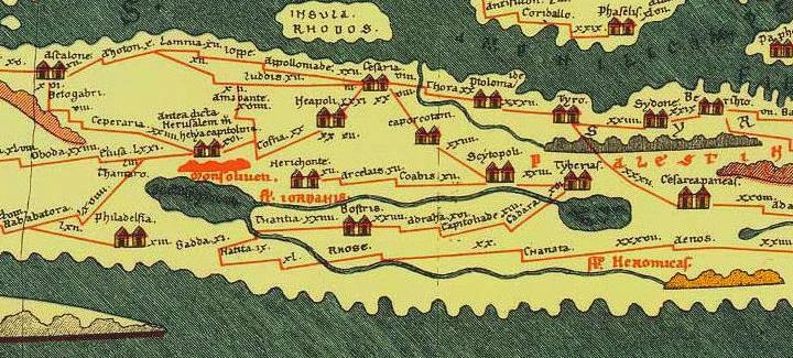
Below (east) of the icon of Jerusalem is an illustration of a hill, listed as Mount of Olives as “Mons Oliveti”). Under it is the Dead Sea (“La(cus) aspaltiates” – sea of Asphalt as the Romans called it). Two rivers flow into it – the Jordan (“Jordanis”) and the Yarmuch (“Heromicas”, which is a cartographic mistake since it flows south of the Sea of Galilee).
The major roads that lead to Jerusalem are shown on the map:
-
South through Elusa (Haluza), Obada (Avdat) and then to the Sinai desert
-
South-east through Zin, Tamar (Thamaro – either Ein Hazeva or Mezad Tamar), then to the Arava and Eilat (not shown).
-
South-west through Ceperaria (Kefar Zacharia) and Betogabri (Beit Gubrin) to the major city of Ashkelon (“Ascalone”) and Gaza. See a section of that road in Horvat Hanut and Valley of Elah.
-
Through or towards Gofna there are two roads:
-
West to Emmaus (“Amauante”) to Lod/Lydia (“Luddis”), and through there to Jaffa (“Joppe”).
Read more about this road.
-
North through Shechem (“Neapolis”) to Caesarea (“Cesaria”).
-
Sites of Roman roads to Jerusalem:
The major roads to/from Jerusalem, and the connected places, appear on the following illustration:
The major Roman roads are:
- Lod-Emmaus-Jerusalem
- Ashkelon-Beit Guvrin-Elah valley-Jerusalem
- Hebron to Jerusalem
- Jericho to Jerusalem
- Neapolis-Gophna to Jerusalem
- Lod/Lydda to Jerusalem
These Roman roads are detailed below, with a sample of photos and sights along the road.
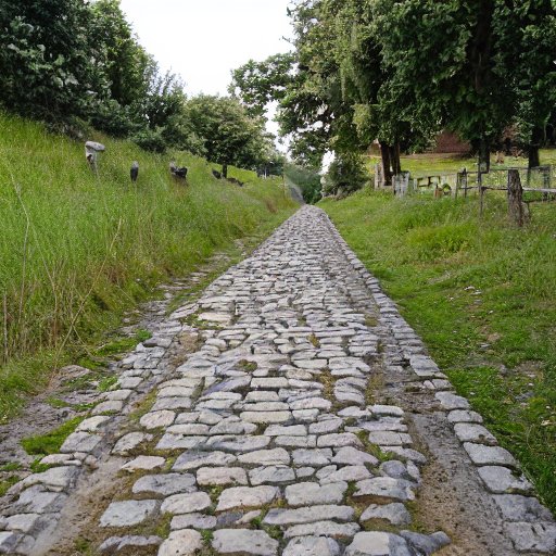
(a) Lod-Emmaus-Jerusalem road
This photo shows a section of the Roman road from Lod, thru Emmaus, to Jerusalem. A group of milestones were collected at this area. This section is near Sha’ar Hagay, above the valley of Nahal Ilan.
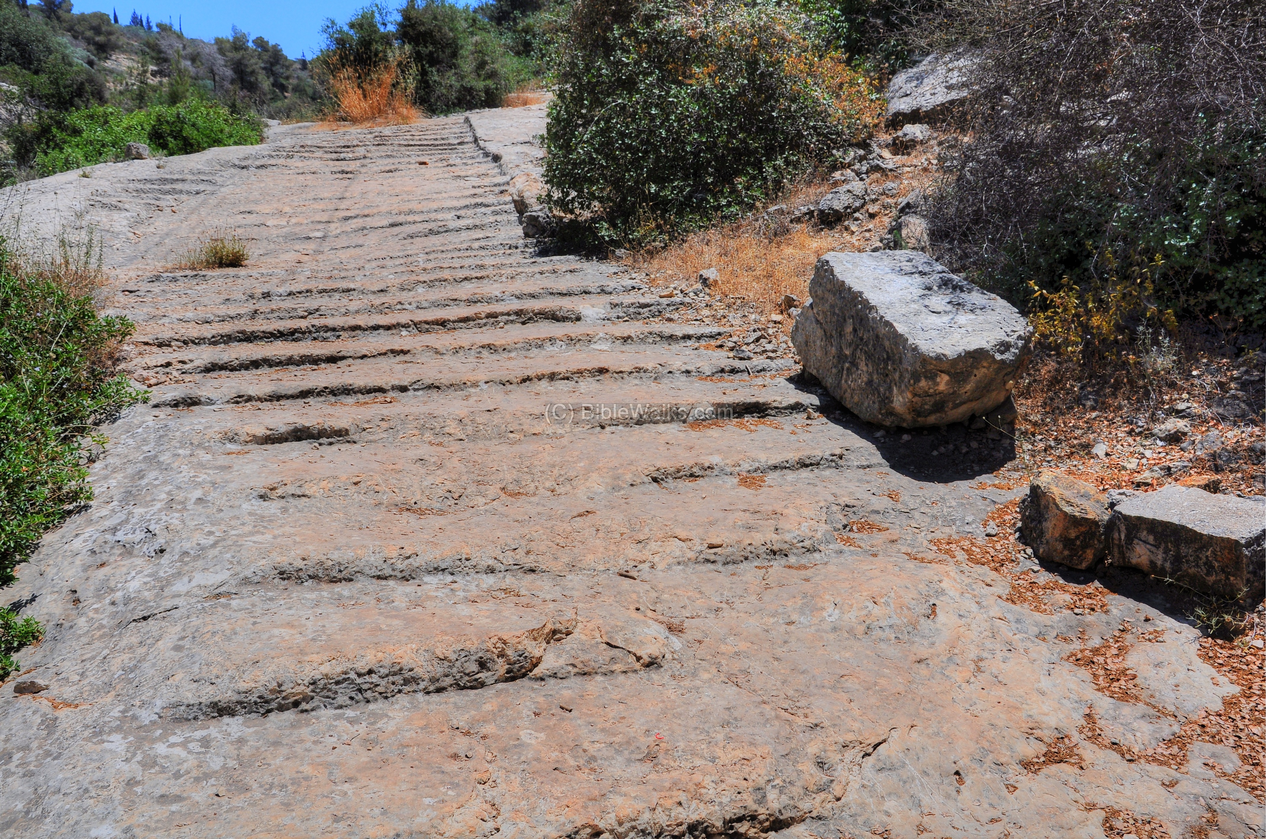
The next photo is another section of this road from Emmaus to Jerusalem. It is located south of Neve-Ilan hotel, about 4km to the east of the previous section. Notice the steps that were carved on the surface of the rock.
![]() See more: Nahal Ilan Road
See more: Nahal Ilan Road
(b) Ashkelon-Beit Guvrin to Jerusalem road
The Southern Road from Beit Guvrin to Jerusalem was an important route during the Roman period, connecting the city of Beit Guvrin (known as Eleutheropolis during the Roman era) to Jerusalem. This road continued west to the coastal cities Ashkelon and Gaza, and south to Beer Sheba. There were 29 milestones along this road, counting from 1 in Jerusalem. Several sections are detailed here.
- Section near Horvat Hanut
Roman steps near Horvat Hanut were part of the road from the coast through the valley of Elah. A group of milestones are also seen nearby.
- Beit Shemesh Kh. Beit Nettif
New excavations in 2016 unearthed a section of the Roman road leading to Beit Nettif, near Beit Shemesh. It may have been a section of the Caesar’s way from Ashkelon, via Valley of Elah, to Bethlehem and Jerusalem.
- Milestones near Givat Yeshayahu
The Roman road turns south from the Elah valley towards Beit Guvrin, along the modern highway #38. It ascends along the valley of Nahal Hakhlil, a tributary stream of the Elah stream, and reaches Nahal Guvrin at highway #35 south of Moshav Nechusha.
Near Moshav Givat Yeshayahu is a group of 5 Roman milestones that were collected during the construction of highway #38. The milestones can be seen in a KKL regional office near Givat Yeshayahu. The milestones are dated to the beginning of the 3rd century AD, and were the 24th milestone of the road from Jerusalem.
![]() See more: Elah Roman road
See more: Elah Roman road
- Section near Nechusha Junction
On the side of the old British road, adjacent to the junction of highway #38 and the road to Moshav Nechusha, are a group of pieces of milestones. They were the 26th milestone along this road.
Thanks to archaeologist Elad Liraz who pointed out to this place. He also wrote a thesis on this road.
- Section near Horvat Goded
Farther south and closest to Beit Guvrin, on the east side of Horvat Goded, are remains of the Roman road and several milestones. The milestones were the 29th mile along this road.
This photo is a view northward toward the valley of Elah. One of the milestone is seen standing in front of the tree. The edges of the Roman road are marked with stones in the field behind the tree.
Thanks to archaeologist Elad Liraz who pointed out to this place.
(c) Hebron to Jerusalem road
This road passed along the Judean mountains, part of an ancient route named the “Way of the Patriarchs”. The exact route of the road is not entirely clear, but it likely followed a path similar to the modern-day Route 60, which runs from Hebron to Jerusalem. The road would have been used primarily for military and trade purposes, allowing Roman troops and merchants to move quickly and safely between the two cities. It also served the pilgrims that flocked to the Holy City during the Byzantine period.
There were 29 milestones along the Roman road from Hebron to Jerusalem. At the section north of the Gush Etzion community of Alon Shvut is the twelve (XII) milestone.
A public ritual bath (Mikveh) was built on the side of the road.
Another milestone (XI) is located 1.5km north of XII, on a road south of the community of Neve Daniel.
(d) Jericho to Jerusalem
There were 14 milestones along the road from Jericho in the Jordan valley, to Jerusalem. Sections of this road passed along the modern highway #1, passing near the Inn of the good Samaritan. This photo shows a section of an old road east of the inn, which may have been used during the Roman period.
(e) Gophna to Jerusalem
The Roman road from Gophna, north of Jerusalem, had 13 milestones along the road.
Gophna (Gofna, Gophanit) was a Jewish village during the Roman period, located in the Judean Hills north of Jerusalem. It was located near major trade routes, including the Jaffa Road, which connected the coast to Jerusalem thru Antipathris (Tel Afek), and the road that led from Jerusalem north to Neapolis (Shechem, Nablus) and beyond to the Galilee via Samaria.
Additional milestones continued the count of Roman miles from Gophna to Neapolis (XVIII-XXVIII).
(f) Lod/Lydda to Jerusalem along Beit Horon
This road passed along the Beit Horon valley, and joined to the road to Gophna at Beit Hannina (on the side of modern highway #404 north of Jerusalem).
Biblical References:
Micah 4 1-2
I searched for a proper verse that will describe the roads to Jerusalem, and found it in Micah (Micha). The verses describe Jerusalem as the center of the world, and all nations will come to it to seek God.
“But in the last days it shall come to pass, that the mountain of the house of the LORD shall be established in the top of the mountains, and it shall be exalted above the hills; and people shall flow unto it. And many nations shall come, and say, Come, and let us go up to the mountain of the LORD, and to the house of the God of Jacob; and he will teach us of his ways, and we will walk in his paths: for the law shall go forth of Zion, and the word of the LORD from Jerusalem”.
Etymology:
- Via – Latin for “road”
- Derech – Hebrew: road, way.
- Micah – Hebrew for “Who is like God?”
Links:
* Internal:
-
-
- Roman roads in BibleWalks.com
- Emmaus-Jerusalem road (Nahal Ilan)
- Elah valley Roman road
-
* External:
-
-
- Section of the Shechem-Jerusalem Roman road found in Beit Hanina excavations
- Roman roads to Jerusalem (pdf)
-
BibleWalks.com – walk with us through the sites of the Holy Land
Condemnation<<<—previous site–<<< All Sites >>>—>next Jerusalem site—>>> Jerusalem Roman Streets
This page was last updated on Apr 11, 2023 (new sections, illustration)
Sponsored links: