A collection of Roman milestones, on the road along the valley of Elah.
Home > Sites > Judea > Elah Valley > Roman Road
Contents:
Overview
History
Sites
* 24th Mile Station
* 26th Mile Station
* 29th Mile Station
Etymology
Links
Overview:
This web page reviews a collection of Roman milestones along the route of the Roman road, thru the valley of Elah and Nahal Hakhlil, a tributary stream of the Elah stream. The road connected Ashkelon and Gaza to Jerusalem.
History:
-
Roman roads
Roman roads were an important part of the infrastructure built during the Roman period in Israel, which lasted from 63 BC to 324 AD. These roads were built by the Roman Empire to facilitate trade, communication, and the movement of troops throughout the region. They set up roads that enabled an efficient route through the tough terrain. Josephus Flavius (Wars, III 6 2): “… to make the road even and straight…that the army might not be in distress, or tired with their march”. Some sections of these Roman roads and their milestones are still visible today and can be explored by visitors to Israel.
A Figurative Roman road – AI generated by Stable Diffusion
- Roman road along the Elah Valley
One of the major Roman roads from Jerusalem to the coast passed through the Elah valley, following the path of Biblical way. The Roman road on this section is part of the ancient road from Ashkelon, a large Roman port city on the coast, to Bethlehem and Jerusalem. The road passed along the valley, then turn south and continued along the valley of Nahal Hakhlil, a tributary stream of the Elah stream, and reaches Nahal Guvrin at highway #35 south of Moshav Nechusha.
Roman soldiers along a road – AI generated by Stable Diffusion
The Roman road was repaired and enlarged during the campaign of the Roman Caesar Hadrian, who crushed the second Jewish revolt against the Romans – known as the Bar Kochba revolt (132-136AD). This date of the construction is not certain, and relies on the inscription on a milestone found along the road. Bar-Kochba and his troops made their last stand against the might of the Roman forces in Betar, a fortified village which is located along the road.
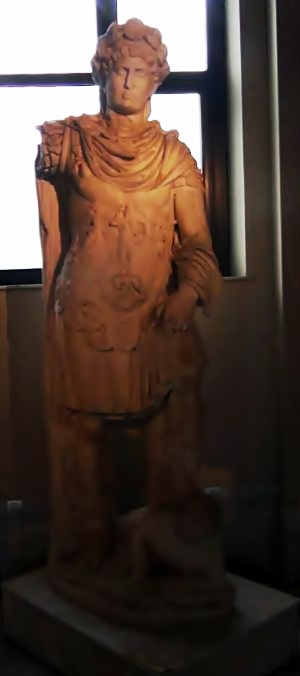
Emperor Hadrian 117-138
[Istanbul Archaeological Museum]
-
Septimius Severus
The city of Eleutheropolis (Greek: “city of the free”) was founded in 200AD in the site of Beit Guvrin. Coins commemorating the founding of the city were issued by Lucius Septimius Severus, Roman Caesar from 145AD to 211AD, who gave the city its freedom status.
This Caesar arrived here at autumn of 198, and the milestones at this location were dedicated to him probably before his arrival. The road was probably repaired during his army’s movement towards Egypt (199).
Bust of Septimius Severus
(from Roman coin; 198AD)
- Late Roman period:
The Peutinger Map (Tabula Peutingeriana) is a medieval map which was based on a 4th century Roman military road map. The map shows the major roads, with indication of the cities, and geographic highlights (lakes, rivers, mountains, seas). Along the links are stations and distance in Roman miles (about 1.5KM per mile). The roads are shown as brown lines between the cities and stations. In the section shown below is the area of Jerusalem, drawn in a rotated direction (Egypt on the left, the Mediterranean sea on the top). Jerusalem is illustrated in the center as a double house icon, which represents a major city. It is listed as “formerly called Jerusalem, now called Aelia Capitolina” (antea dicta Hierusalem n(unc) Helya Capitolina).
The section where the Roman road passes through the valley is indicated as a red square. Ashkelon is marked as “Ascalone”. Stations along the road are marked as:
-
“Caper (zac) aria” – Kefar Zacharia (XXIIII=24 miles from Jerusalem), located on Tell Zakariya, north of the location of the milestones
-
“Beto gabri” – Beit Guvrin (additional VIII=8 miles, and XVI=16 miles from Ashkelon). Also known as Eleutheropolis – city of the free.
The total distance of this road is 48 Roman miles, or about 71km – the actual distance between the two cities.
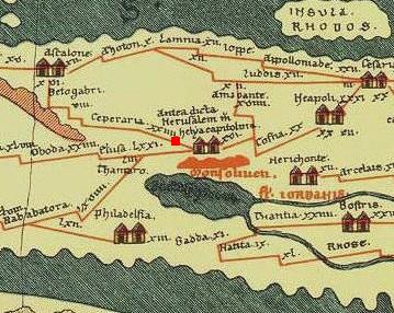
Part of Peutinger map, based on 4th century Roman road map.
-
Ottoman period – PEF survey
The first persons who explored and documented the road-system in the Holy land were Conder and Kitchener, who published their reports in the Survey of Western Palestine (1881).
This site of the 24th milestone is marked in the center of the section of their map of 1878 (by a yellow square). The surveyors marked the group of milestones as “R.M.S” – Roman milestones. Valley of Elah appears on this map in its Arabic form – “Wady es Sunt” (the valley of the Acacia) – although only the word “Wady” is seen on the right.
The Roman road passing thru the place is marked as double dashed lines with the title “Roman road”. It meets another road on the right side which passes thru the valley of Elah and is directed towards Jerusalem.
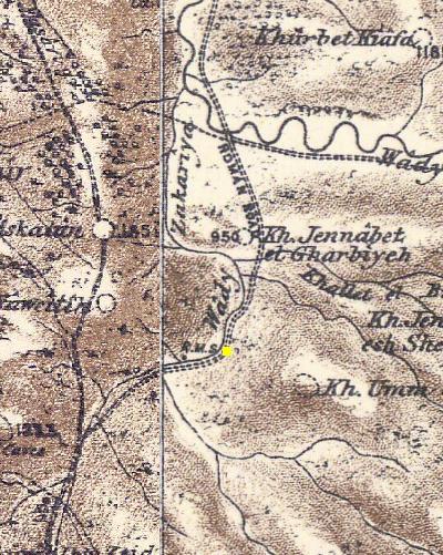
Part of Map Sheets 16&17 of Survey of Western Palestine, by Conder and Kitchener, 1872-1877.
(Published 1880, reprinted by LifeintheHolyLand.com)
Sites of Milestone Stations:
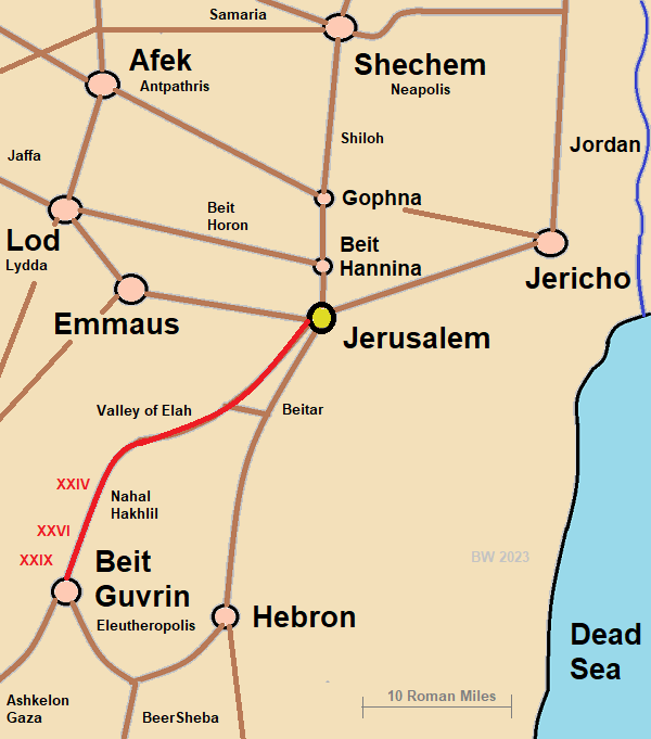
Three milestone stations are detailed in this section – the 24th (XXIV), 26th (XXVI) and 29th (XXIX). Their location is pointed on the road from Jerusalem to Beit Guvrin (Roman Eleutheropolis). All three locations are in the valley of Hakhlil – a tributary stream of the Elah Valley.
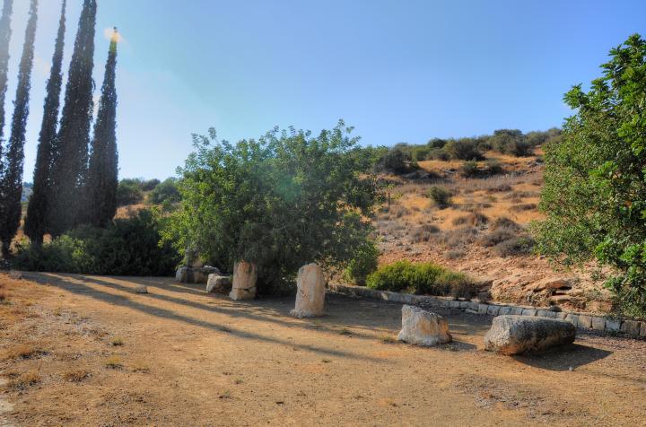
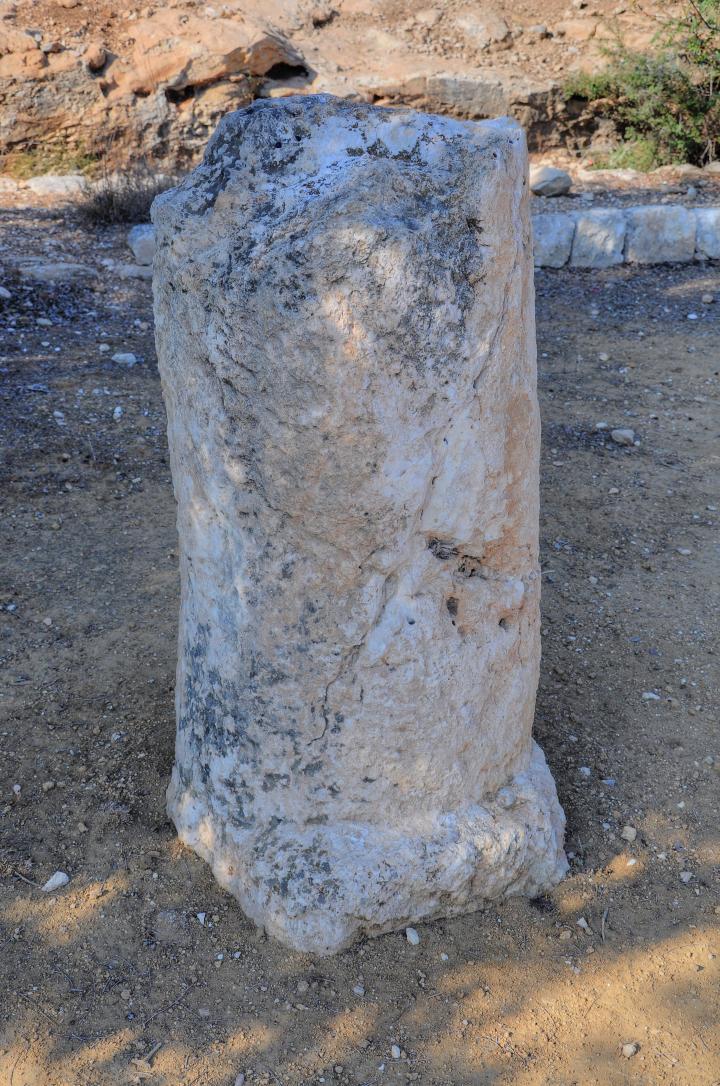
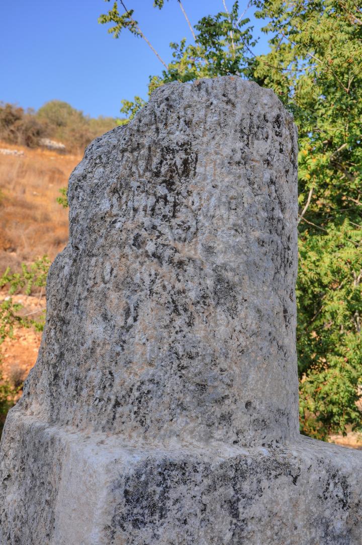
(a) 24th Mile Station
A number of Roman milestones were collected from the road that passed at the 24th (XXIV) milestone location near Givat Yeshayahu, and grouped together. The collection of milestones was first located on the western side of the road #38 south of the Elah junction. It then was moved to the eastern side of the road, inside the archaeological park of the KKL visitor center.
This aerial map shows the location of the old and new sites of the milestones:
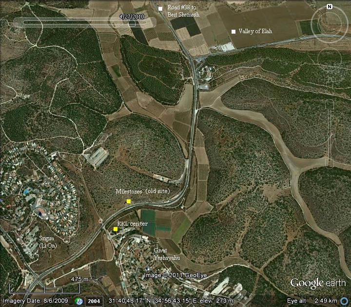
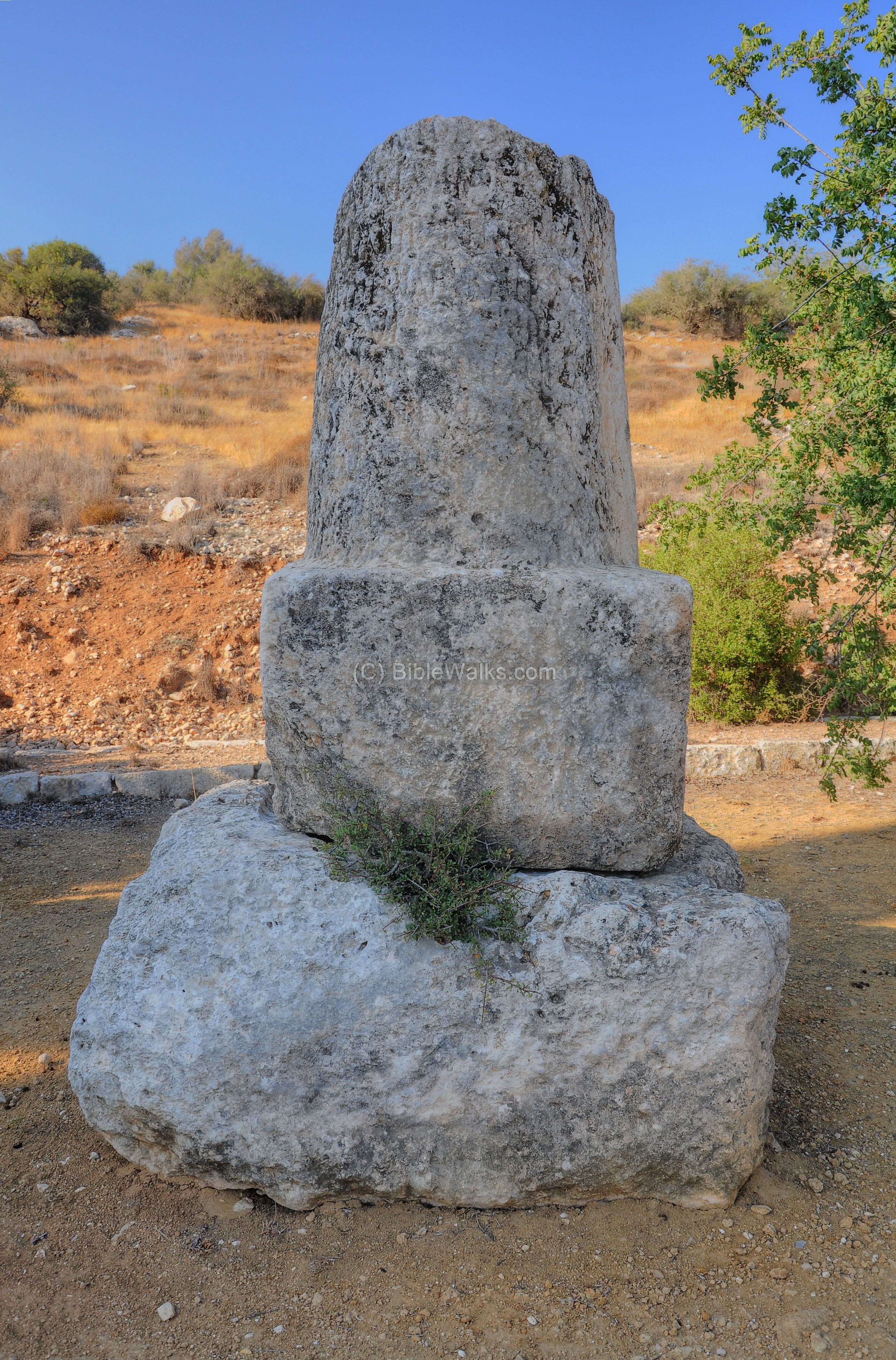
The stones have a shape of a round column, set over a square base. The milestones are dated to the beginning of the 3rd century AD.
Click on the photos to view in higher resolution…
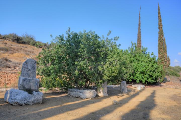
Roman milestones are usually made of limestone, and are 1.5-2.5m high. They are inscribed with Latin or Greek inscriptions, and in most cases bear the name of the Caesar, the road name (in this case – Ashkelon/Beit Guvrin to Jerusalem), the position or range along the road, and an optional blessing to the Emperor and his family.
(b) Milestone 1
The best preserved milestone is seen in the picture below. This milestone, dated to 198AD, is dedicated to the Caesar Lucius Septimius Severus (145AD – 211AD) who visited the area and has passed with his army on the way to the campaign in Egypt. During his visit he gave Beit Guvrin a free status, and renamed it Eleutheropolis (“city of the free”).
The milestone honors the Caesar, his eldest son Caracalla (Marcus Aurelius Severus Antoninus Augustus, reigned 198-217), and his other son and joint emperor Geta (Publius Septimius Geta Augustus, reigned 209-211).
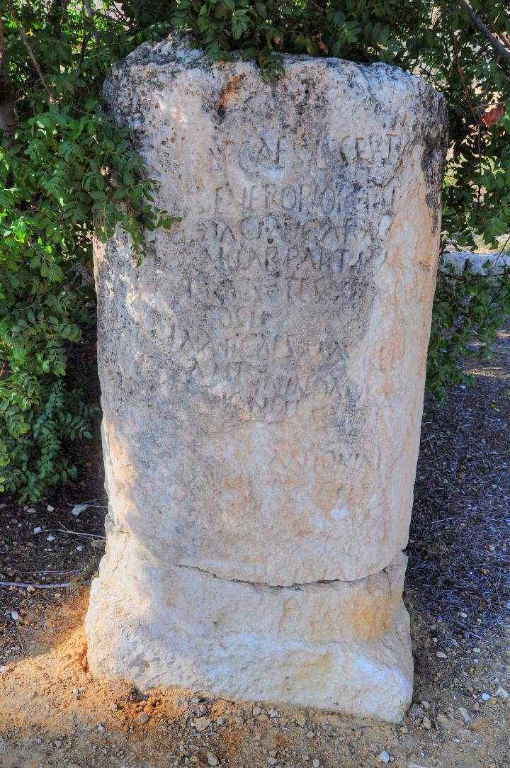
A closer view on the Latin text, and its meaning on the right:
IMP CAES L SEPT Emperor Caesar Lucius Septimius
SEVERO PIO P AVR Severus, Father of the Fatherland
….
ANTONIN (Marcus Aurelius) Antoninus – Caracalla son of Severus
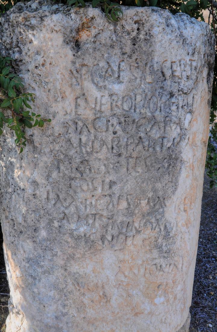
At the bottom of the milestone is the range from Jerusalem (Aelia Capitolina) – 24 miles. Note that this is the exact range that appears on the Peutinger map (“XXIIII”, near the station Caper (zac) aria).
(c) Milestone 2
Another milestone is shown in the next picture:
(d) Milestone 3
Another segment, also with visible inscription, is seen below. It stands above a milestone base.
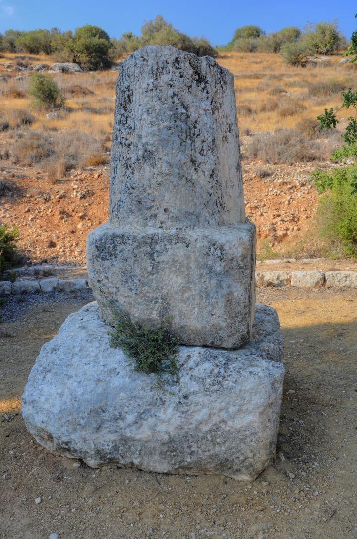
Another view of this milestone:
(f) Milestone 4
Another smaller segment of a milestone:
(f) Milestone 5
The following picture is a base of another milestone:
(b) 26th Mile Station
Farther south, on the side of the old British road and adjacent to the junction of highway #38 and the road to Moshav Nechusha, are a group of pieces of milestones. They were the 26th (XXVI) milestone along this road, and during the construction of the road they were piled on the side.
Thanks to archaeologist Elad Liraz who pointed out to this place. He also wrote a thesis on this road.
Here is one of the more complete milestone. There are no visible markings on it.
(b) 29th Mile Station
Closer to Beit Guvrin, on the east side of Horvat Goded, are actual remains of the Roman road.
This photo is a northward view toward the valley of Elah. The edges of the Roman road are marked with stones.
Thanks again to archaeologist Elad Liraz who pointed out to this place.
At this site are several milestones of the 29th (XXIX) mile location along this road.
A closer view of one of the milestones. There is no visible marking on the stone.
Etymology:
* Nearby villages:
- Givat Yeshayahu – A Moshav near the site, established 1958. Named after Yeshayahu Press – an Israeli researcher (1874-1955) Givat – Hebrew: “The hill of Yeshayahu” – Hebrew: Isaiah (the prophet)
- Srigim, Sarigim – Communal settlement, established 1960. Named after the Hebrew word for branches of grapevines (Genesis 40 10): “And in the vine were three branches: and it was as though it budded, and her blossoms shot forth; and the clusters thereof brought forth ripe grapes”.
- Li On – other name of Srigim/Sarigim. Hebrew: “I have the power”.
- Nechusha – Hebrew name of the Moshav, established 1955. Its name was derived from the Biblical town of Ir-Nachash “Serpent City” (1 Chronicles 4:12), initially identified at Deir Nakhkhas on the side of Highway #35.
* Beit Guvrin:
- Beit Guvrin – Aramaic – Beit (house) Guvrin (men), “House of the men”
- Beit Jibrin – Arabic name of the ruined village, which preserved the ancient name
- Eleutheropolis – City of the free (founded by Septimius Severus, 200AD)
Links:
* Internal web pages – Elah valley:
- Shaaraim – “Two gates” on the north side
- Sochoh – Biblical city on the south side
- Azekah – Biblical city on the west side
- Adullam – Where David hid in the cave
* Internal pages – Roman Roads
- Roman roads
- Roads to Jerusalem
- Horvat Hanut – group of milestones along the same road
- Tel Ashkelon
* Milestones:
- The Near East under Roman Rule – Selected papers – Benjamin Isaac (pp48-74) – great review
- 5 Milestones near Givat Yeshayahu – Y. Landao (pp 232-235, ידיעות בחקירת ארץ ישראל ועתיקותיה, תשכ”ד)
BibleWalks.com – All the Holy Roads lead to Jerusalem
Adullam<<<—previous Judea site–<<< All Sites >>>—next Judea site—>>>Beit Shemesh
![]()
This page was last updated on Aug 5, 2024 (add link)
Sponsored links: