A multi-period site near an ancient crossing point of the Jordan river.
Home > Sites > Jordan Valley > Dalhamiya
Contents:
Background
Location
History
The Sites
Photos
* Overview
* Foothills
* Top of Hill
* Around the site
* Ceramics
* Stones
* Metal
Etymology
Links
Background:
A multi-period site, on a flat hill overlooking the Jordan river, near an ancient river crossing point.
Location:
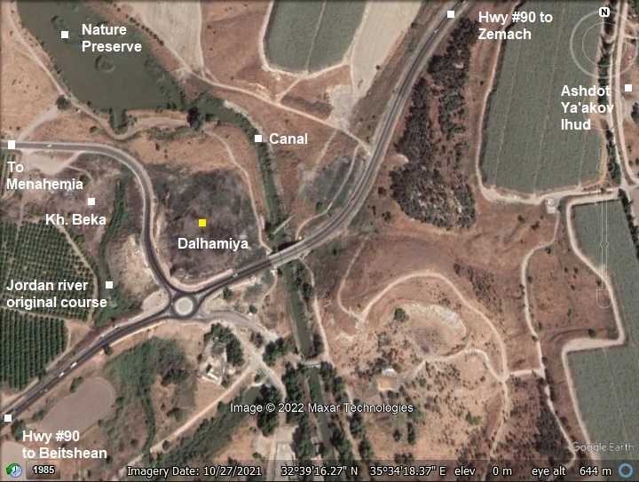
This map shows the area around Khirbet Dalhamiya. The original course of the Jordan river passed on the west side of the mound, between Kh. Beka and Dalhamiya. Today some of the waters of the Jordan river are conveyed along a concrete canal to the (closed) Rutenberg power station.
History:
The multi-period site was inhabited since the stone age. It commanded a river crossing that supported the trade routes connecting the land of Israel to the Trans Jordan mountains and beyond.
Based on surveys and limited digs, the site was occupied during the Chalcolithic period until the beginning of Early Bronze I. Settlement activity was resumed in the Roman period until the Mamluk periods.
-
Biblical map
The cities and roads during the Canaanite and Israelite periods are indicated on the Biblical Map below, with the site marked by a yellow circle on the side of the Jordan river, north of the Yarmouk river.
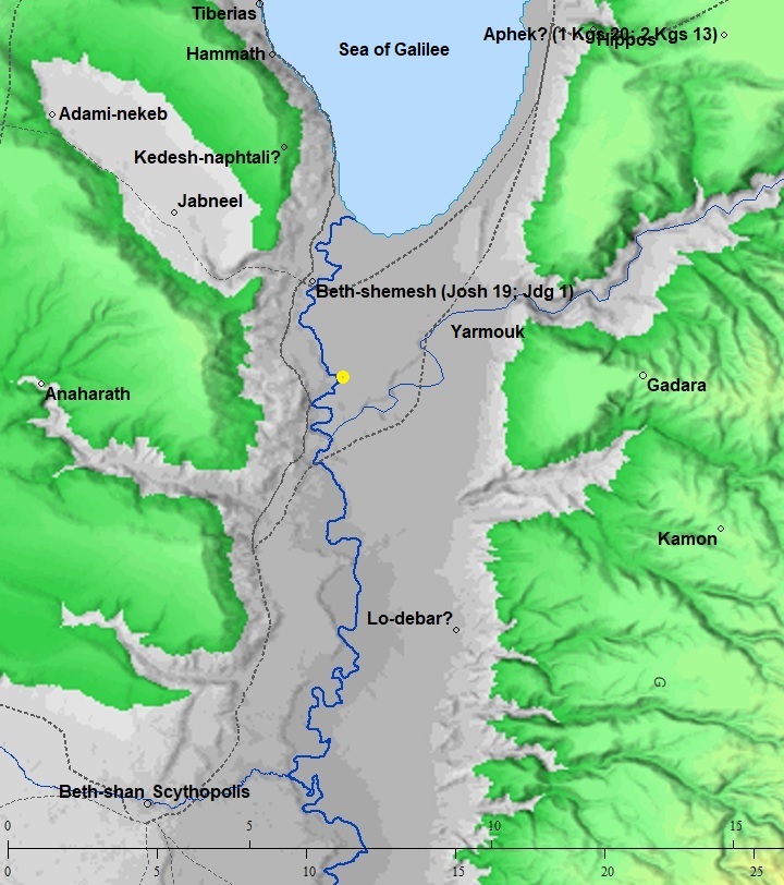
Map of the area of Jordan valley around Dalhamiya (yellow circle)- during the Canaanite and Israelite periods (based on Bible Mapper 3.0)
The location near the crossing was strategically important during the ages, as it guarded the river crossing.
These major routes passed near Dalhamiya:
- A major North-South highway along the Jordan valley passed near the site. David Dorsey (“The roads and Highways of Ancient Israel”, 2018) marked it as Bronze/Iron age ‘A3’.
- ‘T3’ – A West-east road from Tel Rekhesh, along the plateau to Sirin, then descending via Horvat Hagar to the river crossing near Dalhamiya.
- River crossing in antiquity
See Kfar Ruppin sites – another major river crossing.
- Late Roman/Byzantine period
An ancient Roman highway used the same North/South route connecting Beit She’an to the Sea of Galilee. Many Roman milestones were found along the route. For example, the milestones found near Tel Issachar.
The Peutinger Map (Tabula Peutingeriana) is a medieval map which was based on a 4th century AD Roman military road map. The map was made in the 13th century, and copied from an older map. The map shows the major roads, with indication of the cities, and geographic highlights (lakes, rivers, mountains, seas). Along the links are stations and distance in Roman miles (about 1.5KM per mile).
In the section shown below is the area of the Jordan valley, drawn in a rotated direction (south is left, north is right). The major cities appear on this section are: Beit Shean as Scytopoli, Acre as Ptolomaide, Tyre as Tyro, Sidon as Sydone, Tiberias as Tyberias (including the Sea of Galilee as La(cus) tyberias). The roads are shown as brown lines between the cities and stations. The location of the river crossing is marked with a yellow circle on the side of the Roman road between Beit Shean and Tiberias – which is XXIII (23) Roman Miles (34 km).
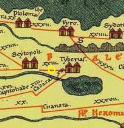
A section of the Peutinger map – yellow circle marks the site
-
Later periods
The site was examined in the PEF survey (1866-1877) by Wilson, Conder and Kitchener.
A section of their map is shown here. The mound, “ed Delhemiyeh”, is located on the east side of the river. The river crossing to the west side was named Mak.t ed Delhemiyeh (Mak.t – short for Makhadet – Arabic for ‘ford’) , and appears as a short line along the Jordan River.
The 19th century surveyors described the state of the village at Delhemiyeh as a miserable mud village, as other villages along the Jordan river (Volume 2, Sheet IX, p. 51): “…miserable mud hovels of Jericho, Scythopolis, and Delhemiyeh…”. Delhamiya is based on the Arabic word – Delham – ‘wolf’.
Kh. Beka is a village west of the site across the river. The surveyors wrote about it (Volume 2, Sheet IX, p. 121): Khirbet Beka —A mound, with no perceptible ruins nor any indication of date”. It guarded the west side of the river crossing.
Part of Map sheet 9 of Survey of Western Palestine,
by Conder and Kitchener, 1872-1877.
(Published 1880, reprinted by LifeintheHolyLand.com)
Train station and bridge:
The Ottomans built a section of the Hejaz (Hijaz) railway from Haifa to Damascus, Syria, more than 100 years ago (in 1905). This railway linked the city and harbor of Haifa to Turkey and Medina (Arabia) until the Independence of Israel in 1948. Since then, it was dismantled and only few of the original rail sections could be seen. The railway passed east of Khirbet Dalhamiya. A bridge over the Jordan river was named Delhamia bridge. A station was named after the Arab village that was located on the north bank of the Yarmouk river.

Al-Dalhamiyya train station, 1930s; Public domain
- British Mandate
A 1940s British map shows the area around the site with more details, although the roads on this map have since changed considerably with newly paved roads..
The site is marked as “Kh. Dalhamiye”. The Jordan river passes on the side of Kh. Dalhamiye. A canal that brought water to the Hydro Electrical power station (2km south of the site) is on the right side of the river.
British survey map 1942-1948 – https://palopenmaps.org topo maps
License: public domain under the UK Copyright, Designs and Patent Act 1998
-
Modern Times
A Hydro-electrical power station was built 2km south of the site, constructed by Pinchas Rutenberg during 1926-1933. It provided electricity until it was abandoned in 1948 following Israel’s independence.
In 1994, following the Israeli-Jordan peace accords, a tourist site named “Peace Island” was opened 1km south-south-west of the Khirbet Dalhamiya, with plans to open up the power station for the public. In 1997 a Jordanian soldier shot and killed seven school girls and wounded 6 others. A memorial park was constructed at the massacre site. In 2019, after 25 years, the “Peace Island” was closed again.
The site is in an open public place and is easily accessed.
Photos:
Tel Dalhamiya is a flat hill on the east side of the Jordan river. This view was captured from the west side of the Jordan river valley, seen here below the site. The valley was once the main path of the river, but some of its water were diverted to the hydro-power station.
Click on the photos to view in higher resolution…
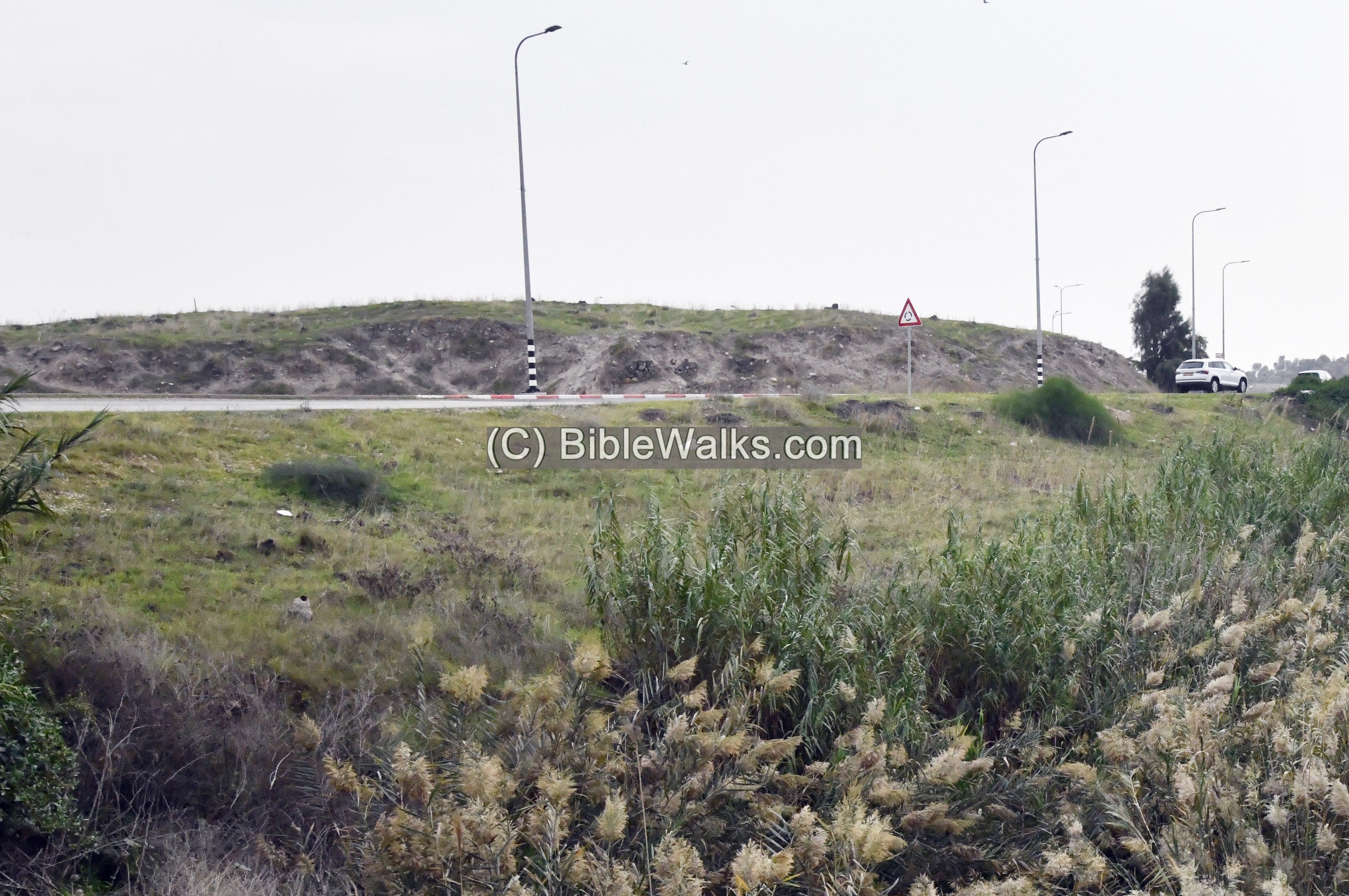
It is within the territory of Israel, between the village of Menahemia and Kibbutz Ashdot Ya’akov. Tel Dalhamiyah’s eastern foothills are along the side of highway #90 (seen below), connecting Beit Shean to Zemach on the south side of the Sea of Galilee.
The sign (“Emek Hamaayanot” – Hebrew for “valley of springs”) is a welcome sign of the regional council for all settlements along the Beit Shean valley. This valley is rich in springs and as a consequence – rich in ancient mounds.
Tel Dalhamiya was protected on all sides by high slopes and surrounding walls, and a moat that surrounded it. The following photos show the slopes around the hill.
First, a view from the west side:
Uncle Ronnie is seen here standing along the slope. Based on his height, the hill is rising ~5m above the surrounding ground on this side.
Section of walls are visible along the western slopes. They consist of medium sized rough basalt stones.
Below is a view of the western slope, looking south, where the road to the village of Menahemia passes at the southern side of the site.
A wide moat is cut in front of the slopes. Since the Jordan river pass near the ancient site, it is probable that the moat was flooded by water to provide a formidable defense.
The northern slopes are even higher.
Beyond the northern slopes, seen below, is a dirt road. Behind it is a modern canal that conveys waters to the hydro-electric station.
On the north east corner is a cut along the slope. This may have been a modern dig into the hill.
The top of the hill is flat with few visible structures. This is a view from the center towards the south.
Another view below – towards the west. On the left background is the village of Menahemia. On the right background is the lake of the Jordan river. The river is split here: east via the canal (right side) and south (left side) by a tunnel under the road.
Next is a view towards the east.
Kibbutz Ashdot Ya’akov is hidden beyond the trees on the north background.
(d) Around the site
There are several points of interest around the site.
The Jordan river flows here from the Sea of Galilee, creating a lake.
A nature reserve (“Morad HaYarden”) was established around the lake, and continues north up to the Yardenit. The nature reserve is open to the public.
A closer view of the lake:
A modern, cement enforced, diversion channel was built in the 1930s to convey the waters to the Hyro-Electric station. Its excavation caused some damages to the fringes of the mound, and also changed the flow of the river.
To the south of Tel Dalhamiya is the original course of the Jordan river. It receives water from the lake by a pipe under the road. You can hear the gush of the water while standing near the course of the river and along it. The river continues under highway #90, turns south and joins the Yarmouk river on the long way to the Dead Sea.
This is a view from the east towards the north west.
At the location around the large tree is another ancient site – Kh. Beka. This site guarded the descent road from Sirin Plateau along Nahal Hagal, and the Dalhamiya river crossing from the west side. The emergency excavation of 1968, built as a preparation to the road construction to Menahemia, revealed 6 layers on the mound. They were dated to the Chalcolithic, Late Bronze, Iron Ages I-II, Hellenistic and Muslim periods. It seems that the missing periods on the eastern mound may have moved to the mound on the western mound.
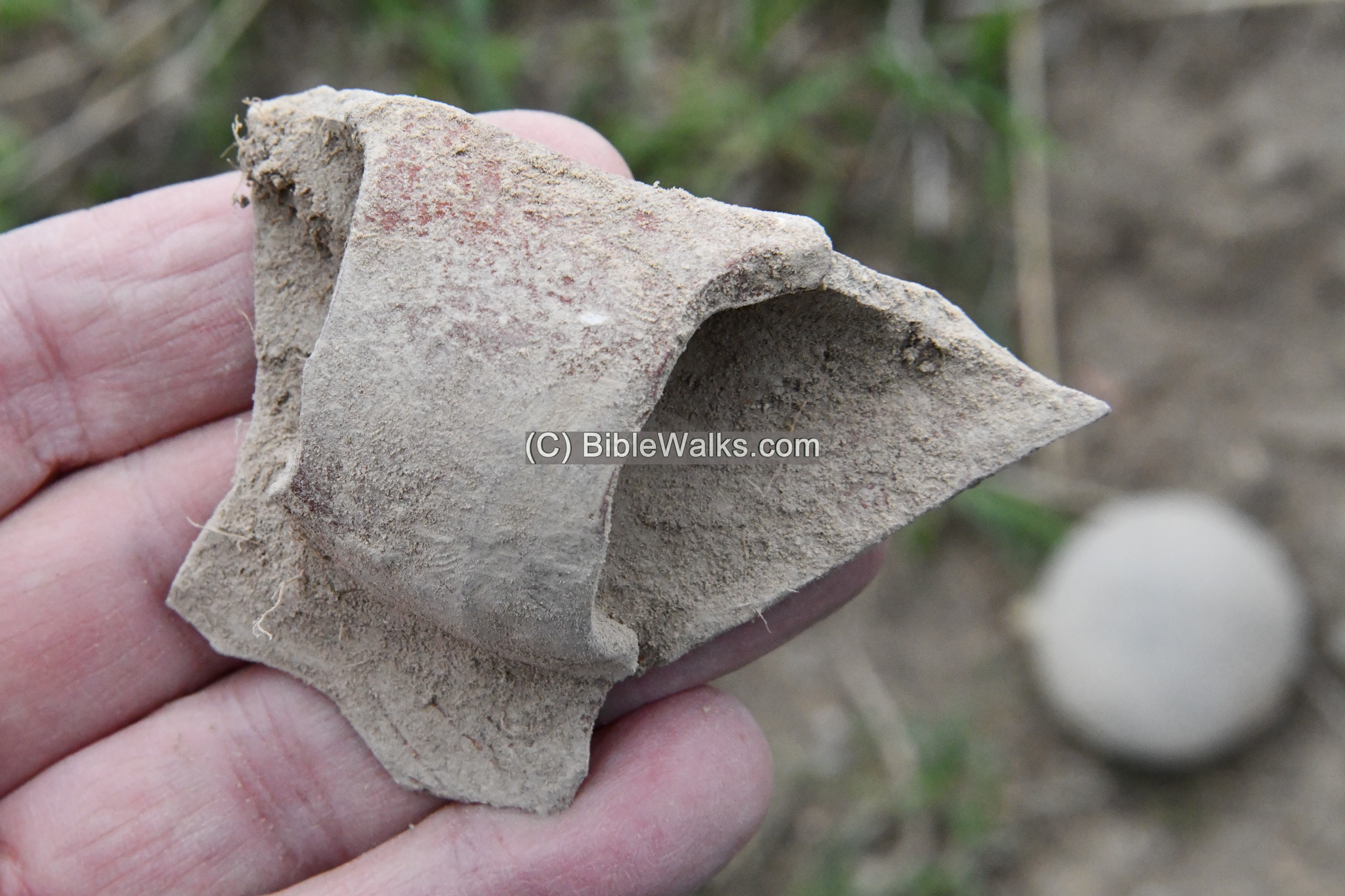
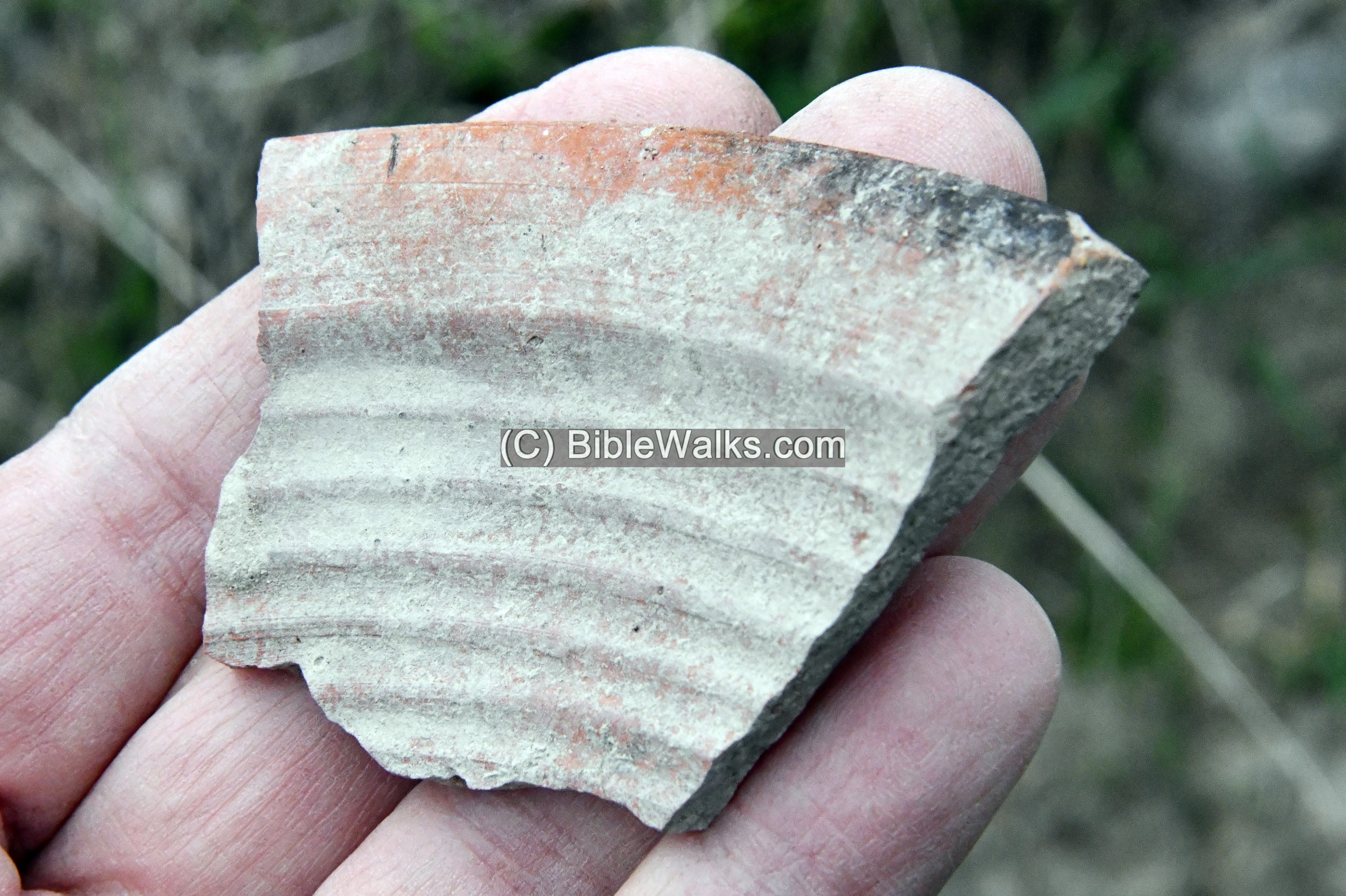
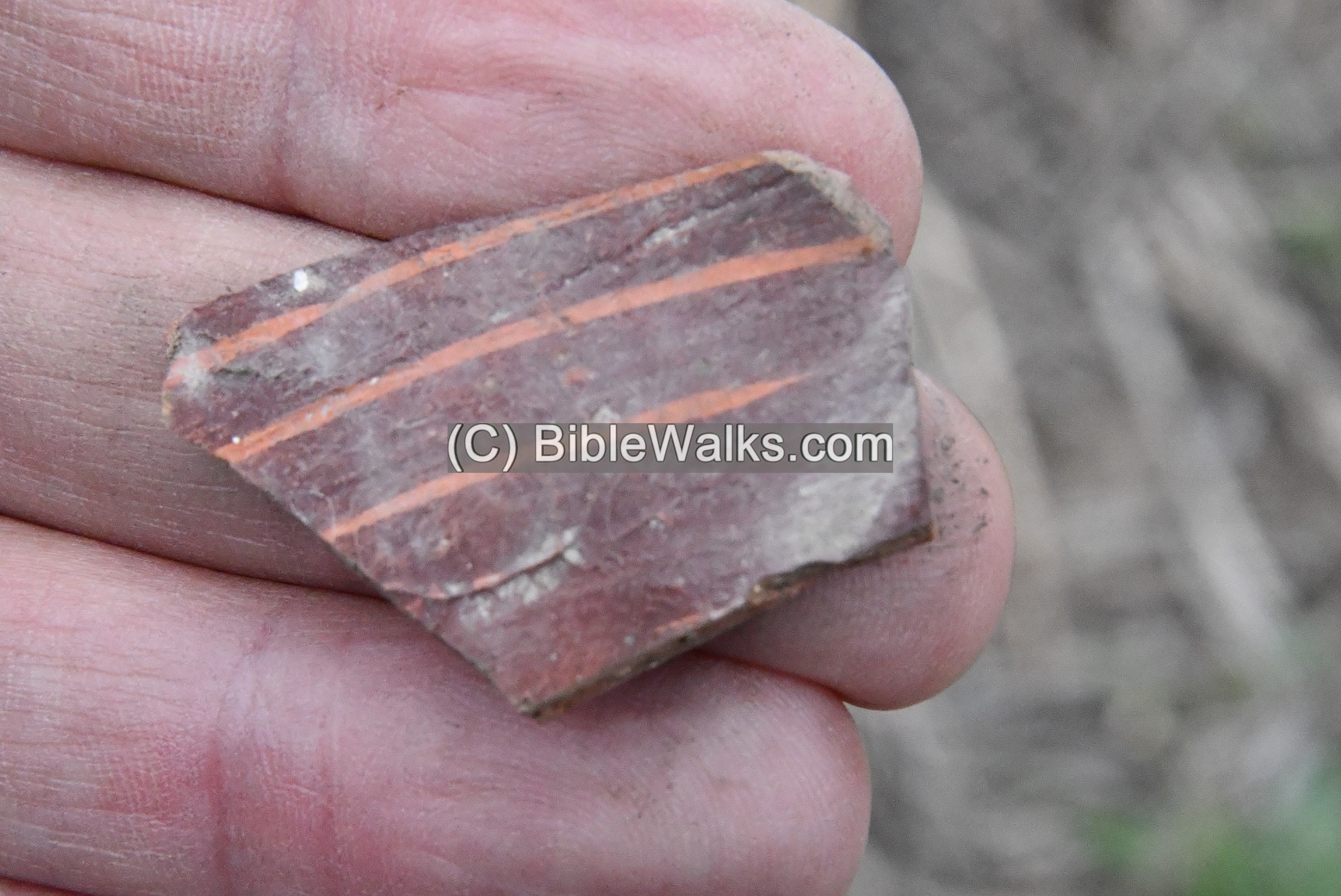
(e) Ceramics
Previous surveys dated the ceramics to the Chalcolithic period until the beginning of Early Bronze I, then after a large gap – from the Roman period until the Mamluk period.
During our short stay on the site, we collected a few samples. All items were left on the site.
1 Roman vessel
2 Roman vessel
3 Roman vessel
4 Roman/Byzantine vessel
5 Muslim colored pottery
6 Early Bronze?

7 Late Chalcolithic decorated body (fingers pressed into wet clay)
8 Unknown ?
9 Late Roman (found across the valley, in the area of Kh. Beka)
10 Byzantine vessel (2 parts)
(f) Stone objects
During our short survey of the hill and on its footsteps, we noticed several stone tools. Here is a sample of what we saw.
1 Large basalt stone with a deep cut
2 Large basalt stone
3 Large basalt stone
4 A rectangular hand millstone, made of basalt stone, probably Roman period.
This type is called “Olynthus mill” or “Hopper Rubber” grain mill. (Reference: R. Frankel’s article, AJA 2003). The process of grinding is where the upper millstone with the grooves is rubbed back and forth over the lower millstone, using a lever. An example is seen in Gamla web page.
5 A chalcolithic basalt artifact
6 Chalcolithic period; perhaps a stone weight for textile production
7 Chalcolithic grinding stone and stone weight for textile production
8 Grinding stone?
The coin in this photo is for reference.
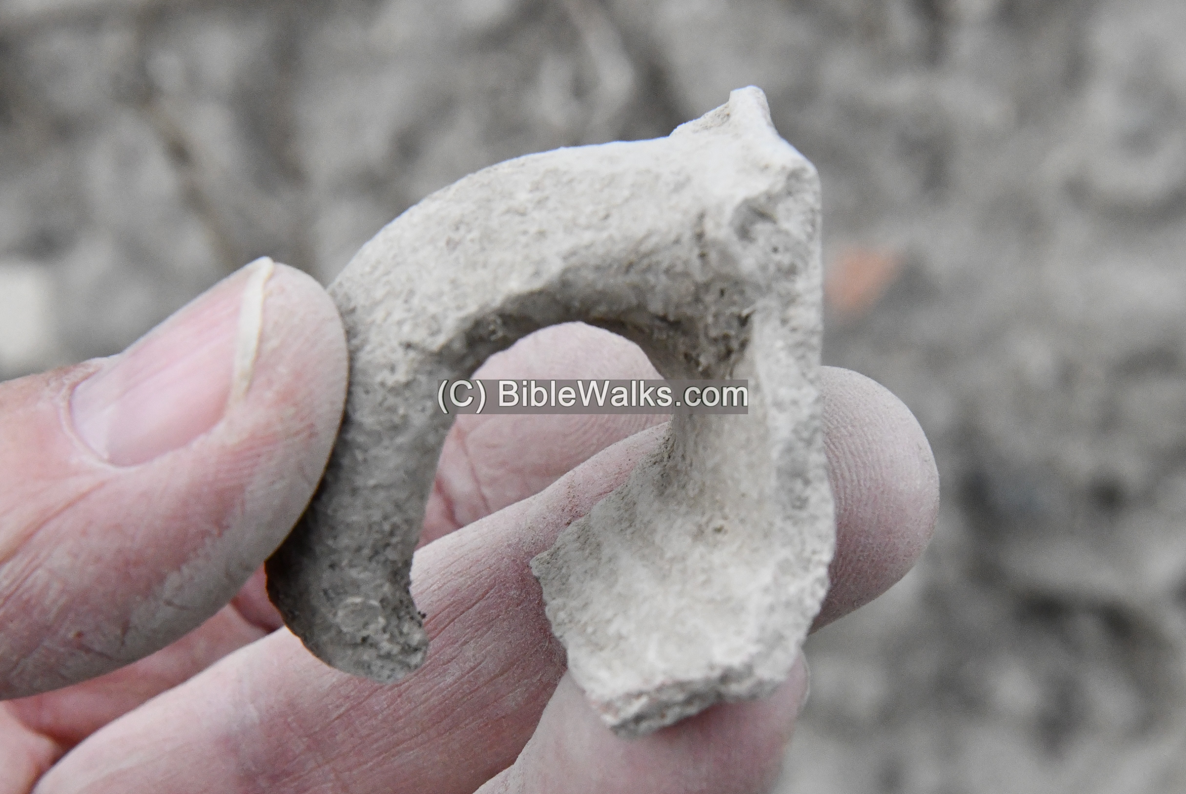
(g) Metal
- An unusual horse shoe
Regular horse shoes are crescent in shape, in order to fit to the geometry of the horse hooves. According to our farrier equine expert, wide horse shoes are used in case of muddy grounds, such as existing here in a river crossing site, as it has a larger contact area than regular horse shoes.
The shoe is dated the Roman period until the Ottoman period. References:
- a. similar item 3rd-4th century, excavated in Germany.
- b. similar item, huge Roman Period Iron Horse Shoe
Etymology (behind the name):
- Tel (Tell) – mound (See more on the story of a Tel).
- Makhadet – Arabic: Ford
- Delhemiyeh, Dahamiya – a family name, from Delham, meaning (Arabic) ‘a wolf.’
- Khirbet Beka – Arabic: “Ruin of the valley”.
- Ashdot Ya’akov – Hebrew: James’s rapids. Rapids – of the Yarmouk river; James- after James de-Rothschild. There are 2 adjacent communities: Ichud (southern side) and Mehuchad (northern side).
Links:
* External, archaeological links:
- Khirbet Dalhamiya – HA 132 2020
- Khirbet Dalhamiya – HA 126 2014
- Khirbet Dalhamiya – HA 121 2009
- Rutenberg and the Jordan river – a revolution in Hydro-electricity
* Other Jordan river crossings:
* Internal links:
BibleWalks.com – exploring the ancient sites of Israel
Ein Hayadid<<<—previous Jordan Valley site—<<< All Sites>>> — Next site—>>>Tell Migda’
This page was last updated on Jan 3, 2023 (update on horse shoe)
Sponsored links: