Ruins of a Bronze/Iron Age mound and Roman/Byzantine settlement north west of Menahemiya.
Home > Sites > Jordan Valley> Horvat Anin (Khirbet Anin)
Contents:
Overview
Aerial Map
History
Photos
* Aerial Views
* Ground Views
* Eastern foothill
* Anin Spring
* Ceramics
Videos
Etymology
Links
Background:
Ruins of a fortified Bronze/Iron age site, and a Roman/Byzantine settlement, situated above a perennial spring, north west of the village of Menachemiya. It guarded a Biblical route that ascended from the Jordan valley to the heights of Sirin.
Map / Aerial View:
The aerial map below shows the area around the site, indicating the main points of interest.

History:
- Bronze/Iron (Biblical) Age
The cities and roads during the ancient periods, up to the Roman period, are indicated on the Biblical Map below. The site is marked as a red circle. The ancient west-east route is not indicated here.
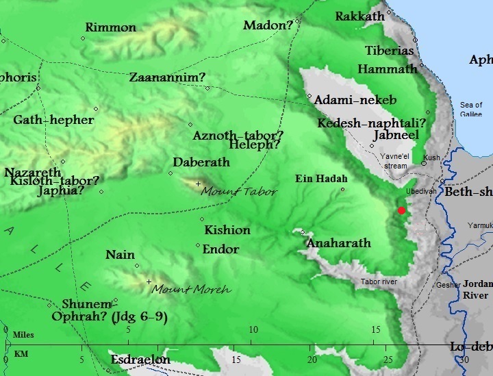
Map of the area – during the Canaanite and Israelite periods (based on Bible Mapper 3.0)
Iron Age roads:
D. Dorsey (“The roads and highways of ancient Israel”, p. 106) named 2 roads that passed at this place down to the Jordan river ford of Ubeidiya:
- T2 (from Mt. Tabor, via Tel Ein Haddah)- a west-east Biblical route passed through the site. The route, designated as “T2”, connected Mount Tabor, through Tel ein Hadda on the Yavne’el heights, descending through Sheikh Muzeighit and Horvat A-Dir, down to Tel Ubediyah road. The road was used for crossing the Jordan river at the ford near Ubediyah, and also for using the Jordan valley route for north and south directions.
- T3a – (from Tel Rekhesh, via Sirin) – another west-east Biblical route that passed at the site.
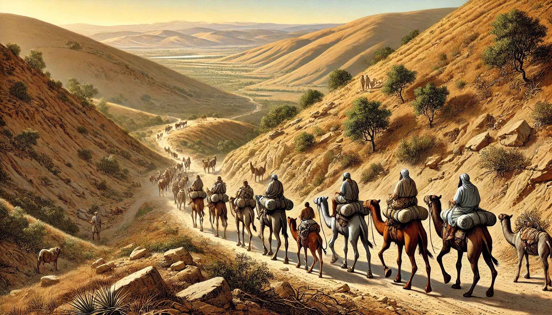
Caravan descending to the Jordan valley – AI generated by Stable Diffusion
The site was part of a network of fortified settlements or posts that were positioned by the Israelite northern kingdom at strategic locations along major roads:
- Horvat A-Dir, a similar Iron age fortress, is 1.5km south east of this site and on the side of the road that descends from this site.
- Horvat Kush, yet another Iron age fortress, is 2.5 km north east of this site. It also guarded an important route descending to the Jordan valley along the Yavne’el valley.
- Israelite period (House of Omri)
According to Finkelstein (“Omride Architecture in Moab: Jahaz and Ataroth”), these Iron age fortified settlements were constructed by the Omri House monarchs (Omri, Ahab, Ahaziah, Yoram, and Athaliah, who reigned during the years 885-835 BC). During these years, the arch enemy Aram-Damascus was probably the trigger to construct defense lines along the eastern frontier.
Omri was a general, who was made king (882 BC) over the Northern Kingdom during the mutiny of Zimri (1 kings 16 16): “And the people that were encamped heard say, Zimri hath conspired, and hath also slain the king: wherefore all Israel made Omri, the captain of the host, king over Israel that day in the camp.”. After regaining the control of his Kingdom, Omri turned to defend his country against their arch-enemy – Aram-Damascus – and the rising empire of Assyria.
Ahab, his son, fought against Aram-Damascus in 3 battles, but was killed (850) in the 3rd battle. Ahab’s son Yoram continued to confront the Syrians, and was killed in Jezreel (842), thus ending the house of Omri. (1 kings 22:35): “And the battle increased that day: and the king was stayed up in his chariot against the Syrians, and died at even: and the blood ran out of the wound into the midst of the chariot”.
The assaults continued from the north: the Assyrians forces – a rising force in the region- hit the Northern Kingdom in 841, and Aram-Damascus headed by Hazael invaded in 815-810, as per Biblical accounts (2 Kings 8:12, 12:18-19, 13:3+7; Amos 1:3) and (2 Kings 10 32): “In those days the LORD began to cut Israel short: and Hazael smote them in all the coasts of Israel;”. In one of these intrusions the city of Rechov, the major city in this region, was violently destroyed. The archaeologists dated this destruction to an approximate date 840-830BC. This was probably the fate of the other Iron Age forts in this area.
- Roman/Byzantine period
The site was resettled during this time, probably below in the area east of the Iron Age mound. In our short survey we found in the field near the spring many pottery fragments of the early Roman to the Byzantine periods (1st-5th century AD), but no architectural elements.
According to Zvi Ilan, the site may have been a small Jewish settlement. Architectural features and building materials, typical of synagogues and settlements of the period, where collected by residents of Menahamiya from the ruin of Anin.
-
Ottoman period
The site was examined in the PEF survey (1866-1877) by Wilson, Conder and Kitchener. A section of their map is seen here, with the site indicated on the map as ‘Anin. A road is shown connecting the village of El Hadetheh (Bronze/Iron age Tel Ein Haddah) to nearby Mizpe Elot (esh Sheikh Muzeighit), but probably it descended thru Anin. Another road from Yavneel and Kh. Shemsin (on the banks of Nahal Yavneel) passed near Anin.
The report did not review the site.
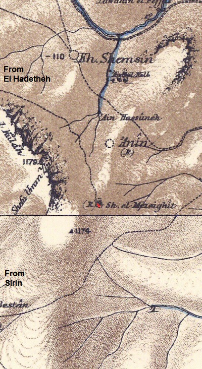
Part of Map sheets 6 & 9 of Survey of Western Palestine,
by Conder and Kitchener, 1872-1877.
(Published 1880, reprinted by LifeintheHolyLand.com)
-
British Mandate
The site was first surveyed by the Finnish archaeologist Aapeli Saarisalo in 1927. In his book (“The Boundary between Issachar and Naphtali”) he reported about his limited excavation and findings at the site (pp 73-74). Here is a summary:
Saarisalo describes Hirbet ʿAnin (Sel-ʿAnin) as a ruin located about 1.5 km east-southeast of the site marked on the Survey of Western Palestine map and at the same distance east-northeast of the sacred tree Sejeret el-Mzerit, close to the Jordan River—only about 1 km away, where the river bends eastward. The site occupies a gently rising slope at the base of a ridge, bordered on the south by a wadi running west–east. The ruin extends about 150 m westward from a spring toward the hill and is roughly oval in shape, about 10 m high. Debris continues for another 100 m northward across the plain beyond a smaller wadi.
Saarisalo recorded massive ruined walls, up to 2 m thick, built without mortar, especially on the western side—suggesting strong construction, perhaps defensive. The northern part of the ruin field is covered with Arabic tombs, indicating later re-use.
Pottery finds included: Early Arabic sherds, confirming early Islamic occupation (the most abundant group); Byzantine-period fragments and mosaic tesserae, pointing to earlier settlement; Bronze Age sherds found east of the mound toward the Jordan, indicating prehistoric occupation.
During water-pipe installation, Jewish colonists dug a 4 m deep trench near the spring and exposed a curved, unmortared wall, which Saarisalo interpreted as the remains of a large round pool where the spring originally issued. The colonists also uncovered two large stone pedestals, now placed in the nearby colony of Milhamiyah (modern Menahemiya), each 76 cm high and 60 cm in diameter at the top.
Interpretation: Saarisalo concluded that Hirbet ʿAnin was a multi-period settlement beside the Jordan floodplain, occupied in Bronze, Byzantine, and Early Arabic periods. Its strategic location near springs and the river, and the remains of strong walls and a large pool, suggest a small fortified settlement or village center with a water cult or utilitarian installation at its heart.
Map:
A section of the 1940s British map shows the area around the site, which is seen above the cliff. Notice that there is a route (a dashed line) that descends from the Sirin heights thru the south side of Anin, continuing south east to Menahamiya. Another route descends thru Kh. Anin on its north side and continues north east to the Jordan crossing at Ubeidiya or continues north to the Sea of Galilee.
British survey map 1942-1948 – https://palopenmaps.org topo maps
License: public domain under the UK Copyright, Designs and Patent Act 1998
- Modern Period
The site was not yet thoroughly researched. During our visits to the site we attempted to understand its structure and history.
Photos:
(a) Aerial views
A drone view from the north east side of the sites is seen here.
The Iron Age site is located in the center of this view, while the Roman/Byzantine period remains are scattered on the field to the east, that are not seen in this view.
Click on the photos to view in higher resolution…
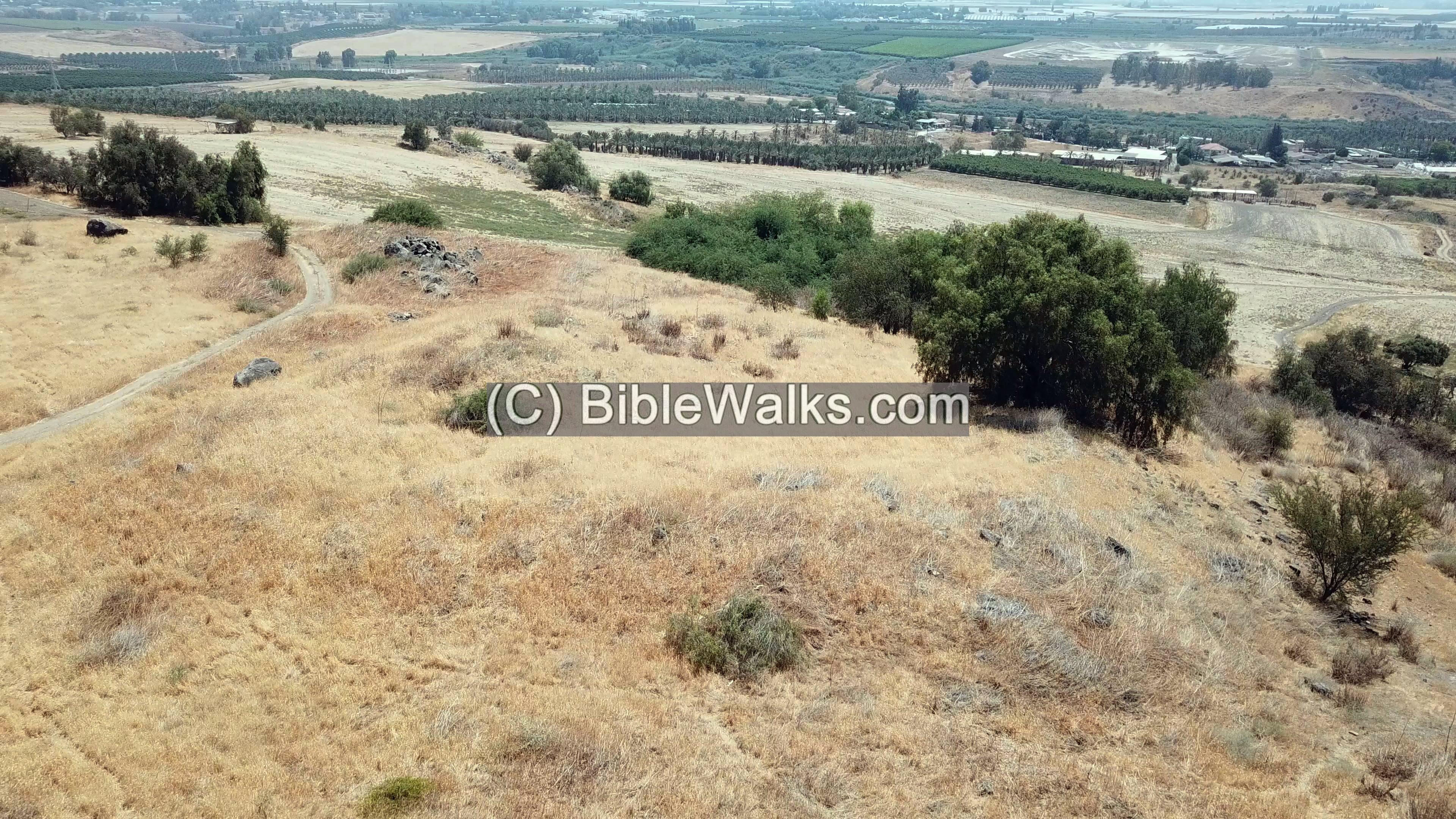
Another view from the drone is from the south west side. Here the western and southern walls are better visible.
In the green bush below the site on the east is the location of the spring of Anin. In the far background is the Jordan valley.
At the time we surveyed the site it was covered with dry weed, but the lines of the walls of the mound were partially visible. Based on our survey, we saw that the upper side of the walls were aligned in a rectangular shape, as marked on this south-west drone view:
To better understand the topography of the site, we used a 3D software to see the plan of the site. A set of mosaic photos were captured by our drone over the site, then were converted to a 3D view by Ayelet Keidar. A “heat map” of the heights was also generated, showing a raised area (orange color) in the center, with slopes on all directions, and low areas on the south and east sides. The larger orange/red objects are bushes and trees.
Based on this map we can suggest that a dry moat was cut into the ridge on the west side, making the weakest side of the mound more defendable. Such similar moat construction was also seen in another iron age site – Horvat Ziwan.
(b) Ground Views
The following view was captured from the north east side, where a road passes along the side and ascends to the west. It follows an Ottoman period road that ascended to the Sirin heights above, seen here in the far background.
The next view is of the center of the site, captured from the south west corner. In the center of the site is a raised area, seen here behind the bush on the left. It is perhaps a base of a structure.
Below in the valley is Menahamiya and the Jordan valley. In the far background are the Jordanian mountains.
- Southern wall:
On the south west corner are remains of a section of a wall. It may have been part of a corner tower, storage pits or a grain silo.
Note that the archaeological stick has 10cm bars.
On the south wall is yet another pile of basalt stones that also may have been used for storage.
To the south of the mound is a deep valley. Between the valley and the southern wall passed an ancient route that ascended to the Sirin heights, as appear on the British map.
Eastern wall:
Along the eastern side are basalt stones that may have been part of the eastern wall.
Along the eastern foothills are many holes that were cut by porcupines. In this hole we found a piece of an Iron Age “Hypo ” jar.
These mammals dig deep into the soft ground and pull out pottery fragments.
- Northern wall:
Along the north side are visible sections of a wall.
(c) East side of the mound
Along the bottom of the eastern foothills is a access road that opens up to the field below.
We found an excellent place for a coffee break under the olive tree.
(d) Anin Spring
Just below the eastern foothills, under the large bush, is the ‘Anin spring.
The spring used to water the fields around and convey water to the village Menahemiya. A heavy door used to seal the spring, but it is now tossed to the side.
The perennial spring flows out of a built tunnel and its waters are collected by a pipe.
(e) Pottery dating
In order to date the site we examined the pottery fragments on and around the site. Previous surveys dated the pottery to Iron Age(?), Byzantine and Mameluke.
- Iron Age:
We were able to find a possible pottery fragment of the Iron Age, that was dug out of the eastern wall by the porcupine.
- Roman/Byzantine:
In the field east of the mound were mainly Roman/Byzantine pottery (1st-6th century AD) as well as Early Muslim/Mameluke, as seen here:
As usual, all findings were left on the site.
A more thorough search and dating will be performed in the future.
Videos:
![]() This video summarizes a field survey of the site by BibleWalks staff, conducted on July 2025. Remains of the surrounding walls were observed during the survey, and pottery sherds were dated. The survey was captured on video and posted as a YouTube video:
This video summarizes a field survey of the site by BibleWalks staff, conducted on July 2025. Remains of the surrounding walls were observed during the survey, and pottery sherds were dated. The survey was captured on video and posted as a YouTube video:
Etymology – behind the name:
* The name of the site:
- ‘Anin – the PEF dictionary explained this name as a private Arabic name.
- ‘Anin (near Jenin) – There is another site near Jenin that was also named ‘Anin. See Conder and Kitchener, 1882, SWP II, p. 51.
- Anin – Hebrew for: sensitive, delicate, refined (a modern phonetic translation from Arabic)
* Other names:
- Menahemiya – The village was established in 1901 (the first Jewish settlement in the Jordan valley).
Links and references:
* References:
* External links:
* Internal links:
-
- Horvat Ziwan – A similar Iron age fortress, south of this site
- Horvat Kush, another similar Iron age fortress, is 2.5km north east of this site.
- Horvat A-Dir – another similar Iron age fortress, is 2.5km south east of this site.
- Mizpe Elot – another Iron age site on a higher ground
- Jordan valley survey – by BibleWalks team
BibleWalks.com – walks along the Jordan river
Horvat Melahat<<<—previous Jordan Valley site—<<<All Sites>>>—next site—>>>
This page was last updated on Oct 12, 2025 (summarize Saarisalo)
Sponsored Links: