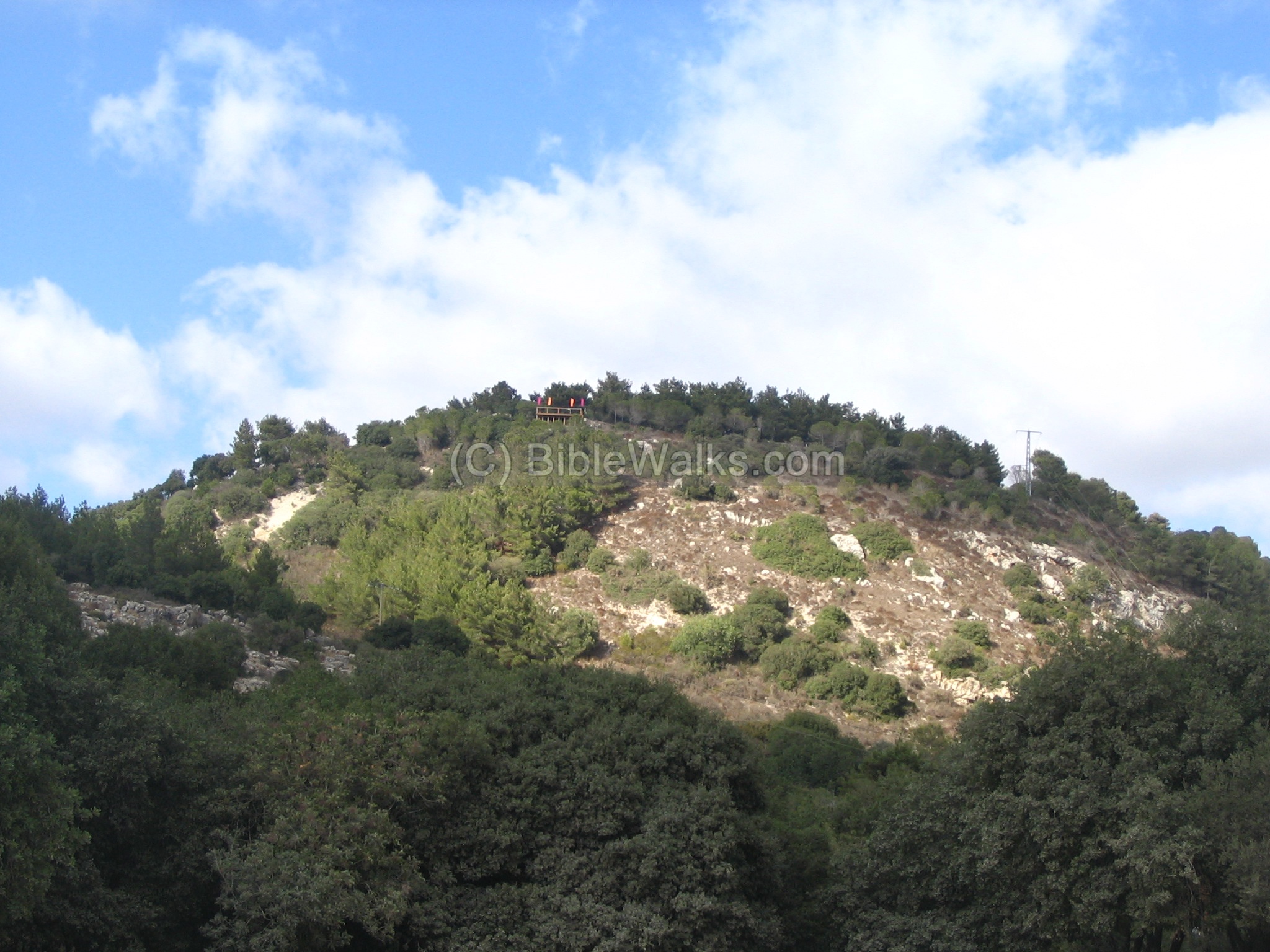
The site is in the center of mount Carmel, on top of a hill, overlooking the Oren valley. It was the largest city on Mount Carmel from the Late Bronze to the Roman/Byzantine periods.
Home > Sites > Carmel > Horvat Oren (Khirbet Shalale)
Contents:
Background
Location
History
Modern
Photos
*General
*South side
*East side
*West side
*North side
*North East side
*Oren Valley
Etymology
Links
Background:
Horvat Oren (Khirbet Shalale or Shallala) is an ancient city in the center of Mount Carmel, situated on the top of a high peak. It is located on a steep hill overlooking Oren valley. It was the largest city on Mount Carmel from the Late Bronze to the Roman/Byzantine periods.
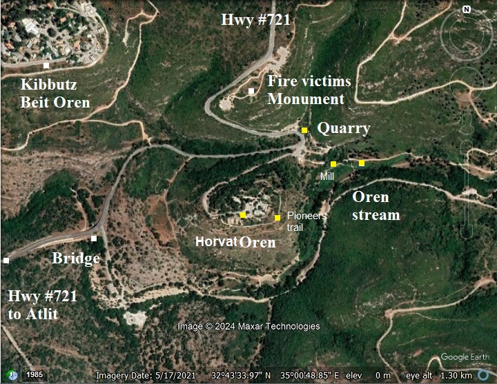
The hill was also called Ya’arot HaCarmel (“the forests of the Carmel”), renamed as Mishmar HaCarmel (“Carmel Guard”) and today houses the park’s offices.
Location:
Horvat Oren is close to Kibbutz Beit Oren, about 10KM south of Haifa, in the center of the Carmel nature park. You can drive here by car from Atlit (driving east and up the Oren valley), or from the University of Haifa (driving 4KM towards the Druze villages, then 2KM south).
History:
- Prehistory
The site has been lightly populated at prehistoric times, at the caves below the hill. The early men enjoyed the flowing waters in the Oren valley, and a natural pond just under the hill. Additional sites were in caves in the lower Nahal Oren area.
- Bronze/Iron age
Settlement on the hill started in the Late Bronze period. Ceramic survey and excavations of the site dated the pottery to the following periods: Late Bronze Age, Iron Age I, Iron Age II. Previous surveys also dated Early Bronze and Middle Bronze period pottery.
This early settlement level was not yet excavated.
During these periods there were few settlements on Mt. Carmel. They were only located around the mountain, situated along the major trade routes (such as Tels Yokneam, Shikmona, Dor, Abu Hawam, Burga).
Biblical significance: Mount Carmel was part of the territory of the tribe of Manasseh, and this site was the major city on the mountain. Mount Carmel, located in present-day northern Israel, holds significant importance in the Bible, especially in the Old Testament. It was a place of great natural beauty, known for its lush vegetation, and symbolized fertility and richness. Mount Carmel was known for its rich plant life. Isaiah 35:2 refers to its beauty, saying, “The glory of Lebanon shall be given unto it, the excellency of Carmel and Sharon.” Its abundant vegetation made it stand out in contrast to the surrounding drier regions. It is not a single peak but a mountain ridge extending about 39km (24 miles) from the Mediterranean Sea inland. Its location gave it strategic importance as a natural boundary between coastal plains and the interior of Israel. The most famous biblical account involving Mount Carmel is the confrontation between the prophet Elijah and the prophets of Baal (1 Kings 18). This took place during the reign of King Ahab and Queen Jezebel, who promoted the worship of Baal, a Canaanite deity.
The fertility and beauty of Mount Carmel made it a symbol of God’s blessings. In biblical poetry and prophecy, it is often used to symbolize abundance and favor (Isaiah 33:9, Amos 1:2).
- Persian/Hellenistic periods:
The city was resettled during the Persian/Hellenistic period (6th-3rd century BC). The excavations unearthed building material of this period that was later reused and incorporated into the Roman city that was built on top of the level of this period. Coins of the Seleucid kingdom were found on the hill.
There are several other sites of the Persian/Hellenistic period in the Carmel (a total of 23 sites) around the site, and close by – like Horvat Alon (1 KM upstream) and Horvat Lubim (2 KM north west). The reason for this increase of sites was the Phoenician harbor cities along the shores of the Carmel (Shikmona, Atlit, Dor, Abu Hawam, and others) and the trade with these cities.
- Roman period:
During the Early Roman period a city was built on the hill. A residential area was unearthed north east of the house, including structures, oil presses, cisterns, reservoirs. The town, apparently large in size, was founded in the 1st century AD and continued until the 3rd century. The archaeologists also found carved stones and a pedestal that may have been part of a Hellenistic or a Roman Ritual structure.
A previous IAA survey also described remains of a city gate on top of the hill, 2.2m wide, built of stones. A hinge hole was observed. We have not yet found the source of this finding.
A destruction level during the Early Roman period implies that the town was damaged during the Great revolt or the Bar Kochba revolts. The settlement was deserted for several dozens of years following the destruction, and resettled at the end of the 2nd century.
The excavations also revealed that an army unit may have camped here, based on a Roman military ornament that was found. The military unit may have been stationed here as part of the Roman efforts to quell the revolts.
The Carmel was at its peak in the Roman and Byzantine periods, mostly after the Jewish revolt in the 1st century AD, when the Jewish population migrated North and the population expanded. The Carmel reached its peak in the 3rd century AD with over one hundred(!) villages, mostly based on agriculture. The road from these villages in the central Carmel went down through the valley of Oren towards Atlit, and therefore the site was a center of trade with these villages, and probably an administrative center. Note that Oren is the largest streams in Mount Carmel, and so the road was the most important in the area and were used by a majority of the inner mountain villages.
Horvat Oren was the largest city on Mount Carmel during this period. It covered the areas east, west and north of the summit. The archaeologists suggested an identification of the site as “Ir Carmel” – Hebrew for Carmel city. They base this hypostasis on the accords of the Roman historian Plinius (AD 23/24–79, aka Pliny the Elder) of an ancient city of the Carmel. (Natural History, Book V, Chapter 15): “We then come to the Promontory of Carmelus, and, upon the mountain, a town of that name, formerly called Acbatana”.
The Roman city was abandoned during the middle 3rd century.
- Byzantine period
The excavations of 2003-2015 (headed by S. Dar and Y. Ben Efraim) also unearthed a column with a cross and a cross pendant, indicating that on the hill was also a Christian community during the Byzantine or Crusader period.
Later traditions suggest that Mount Carmel became a place where hermits and prophets would seek God in prayer. Some sources connect it with the early roots of the Carmelite order, a group of Christian hermits in the 12th century, though that’s outside the biblical timeline. Hermits resided inside a Roman cave complex, located upstream Nahal Oren, 800m to the east. A cross was carved on the entrance to the burial cave.
- Early Islam
After the 6th century AD most of the villages in the Carmel were demolished after the Arab conquest, and the sites remained in ruins since then. The excavations dated pottery from the Early Islam period..
- Crusader/Mameluke/Ottoman:
The settlement continued during the Crusader Mameluke periods, based on coins and ceramics that were dated to these periods. According to an excavation of the flour mill in the Oren stream (Avizur, 1958), the mill was built during the Crusader or Mameluke period.
During the 18th-19th century, Druze settlers lived on the hill but the village was abandoned in 1840 following active hostilities from the Muslim majority on Mt. Carmel.
- Ottoman period:
Conder and Kitchener of the Palestine Exploration Fund (PEF) surveyed the area during the Survey of Western Palestine (SWP) in 1874-75. This is a section of their map, focusing on the area. It shows a mill south of the site, and tombs on and around the hill.
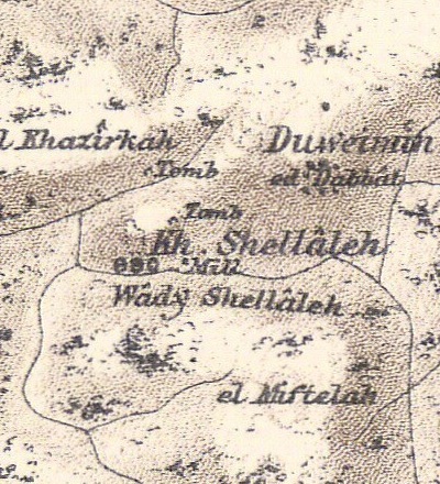
Part of map sheet 5 of Survey of Western Palestine,
by Conder and Kitchener, 1872-1877.
(Published 1880, reprinted by LifeintheHolyLand.com)
The surveyors wrote about the site (SWP, volume I, sheet V, p. 320-321):
“A ruined village, in a very strong position, on a promontory, surrounded by valleys about 600 feet deep with slopes of 35 degrees. On the north-east a road approaches it; below it, on the east, is a broken aqueduct leading to a mill. This aqueduct consists of a small masonry, with two pointed arches; a fragment of a larger stone, 1 ‘ 6″ high, is built in, and on this is a Maltese cross is cut, with a raised border. Several small stones occur in the ruins, with broad flat drafts ; the bosses dressed. Also a lintel, 7 feet long, 2 feet deep, 1 1/2 foot broad, with the face well-dressed; and a draft, 3 inches broad, 1 1/2 inch deep. There is also a pillar-shaft in several pieces ; two caves, some good pieces of ashlar, and on the east a scarp, apparently the foundation of a tower, with rock-cut steps in front on the north-east. Behind the knoll is the quarry from which the masonry came. In it there are two tombs : one a loculus, 8 feet long, 2 feet broad, placed like a koka in the rock, with an arch in front, 4 feet diameter, cut back 2 feet. The second is a chamber 7 paces long, about 3 paces broad, with a recess on the right, 4 paces deep, in which is a loculus, under an arcosolium. At the end of the chamber is a similar loculus. The general impression is that an early Byzantine monastery stood here.
Visited 11th March, 1S73.”
- British Mandate period:
In 1934 there was a single Arabic house in the top of the hill. It was purchased, with the surrounding lands, and settled by a group of 15 Jewish workers. The site served as a watching tower and camp. They intended to build a city here – named Ya’arot Ha-Carmel.
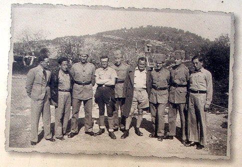
The place was attacked during the Arab revolt in 1936 and some of the workers were killed. In 1939 a Kibbutz (Beit Oren – “House of the Pine”) was established by the another group in the nearby Hill to the west of Khirbet Oren.
A section of the British map of the 1940s is shown here. It shows that on top of the hill is a single house. North west is the location of a newly founded kibbutz Beit Oren (it is spelled wrongly ‘Orel’). On the south side of the hill: a wooden bridge that was constructed at that time to cross the Oren river (Wady esh Shallalah).
On the north side: an ancient road crosses the area of the quarry, continues to Khirbet Damun. The site was a Roman/Byzantine ruin of a monastery and Church, and later a small British mandate period village that was depopulated in 1948. In 1953 the building on the site was converted to a jail.
https://palopenmaps.org – Palestine 1940s 1:20,000 map
- Israel state:
In the 1990s offices for the Carmel park were established on top of the hill. It was initially named “Ya’arot Ha-Carmel” (Carmel forests) and later renamed “Mishmar Ha-Carmel farm” (Carmel Guard farm).
In Dec 2,2010, a disaster occurred near the site, when a massive forest fire claimed 44 lives. The dead were mostly police cadets who perished in a bus that was ascending the road past Khirbet Oren, on its way to the nearby Damun prison in order to evacuate the prisoners. A monument was later erected on the hill above the site to commemorate the dead.
Excavations headed by S. Dar and Y. Ben Efraim, of Bar Ilan University, were conducted on years 2003-2015. The excavations focused on a limited area of the acropolis around the old house.
Photos:
(a) Aerial Views:
This aerial view photo is taken from the bottom of the Oren stream, from the south side. It was captured by a quadcopter 70m above the ground. The ancient site is located on the top of the hill, with steep slopes on all sides. The Oren stream is seen here on the right side, flowing to the bottom side.
Click on the photos to view in higher resolution…
Another view from the south east side is in the next quadcopter photo. Kibbutz Beit Oren is seen here on the left background.
![]() The following YouTube video shows a flight of a drone, viewing the north and east sides of the hill. The video was captured on August 8, 2021.
The following YouTube video shows a flight of a drone, viewing the north and east sides of the hill. The video was captured on August 8, 2021.
(b) South Side:
The steep hill, on which the ruins of the ancient site is located, is covered by bushes and trees around. It is accessible by a road from the north side, and parking is available at the top of the hill.
At the top is a new balcony where you can sit and enjoy the view of Oren valley and the Carmel landscape. This observation place is seen here in the top of the hill.
At the top is a new balcony where you can sit and enjoy the view of Oren valley and the Carmel landscape. This observation place is seen here in the top of the hill.
This is the view from that balcony, looking west. The road passes the Oren’s stream on a bridge, the the road winds down towards the beach, and passing the prehistoric sites at the Oren Caves at the western edge of Mount Carmel.
Further downstream the Oren valley there were several water-powered bread mills, which were used by Arab villagers until WW1. The stream is dry most of the year, but at the spring time- when the wheat grains were farmed – the water could turn the mills.
(c) East side – Pioneers trail
A new walking trail was built along the eastern foothill of the hill. It commemorates Asaf Ramon who was killed during a training mission when his plane crashed in the Hebron Mountains. On the side of the memorial sign is a carved stone in the shape of his plane. Asaf was the son of astronaut Ilan Ramon who died when the space shuttle Columbia disintegrated upon reentry.

The trail curves around the eastern side, from south to north.
From the trail are east views of the Oren valley. The Oren stream continues east to the outskirts of the Druze village of Isfiya. It is a recommended hiking place, accessed by a trail that descends from the parking place on the north side of Horvat Oren.
In this view is the vertical cliff on the north east side – a favorite rappelling place. Under it in the valley are remains of an ancient flour mill. On the top of the mountain on the left side is Damun – location of a ruined Byzantine monastery and a modern jail.
Along the path are several caves that were cut into the hill. One of these caves (marked #40 in the report) was excavated. The archaeologists dated it to the Late Roman period. The hewn cave was used initially as a reservoir, with a volume of 100 cubic meter. The walls and floor are covered by a layer of a grey sealing plaster.
A stair case leads down to the floor.
The cave was converted at a later stage to storage and working area. On the floor are several hewn stones.
Past the northern section of the trail is an ancient stepped trail that descends to the parking area on the lower north east side. It is built between two parallel fortification walls, similar to an Iron Age casemate wall.
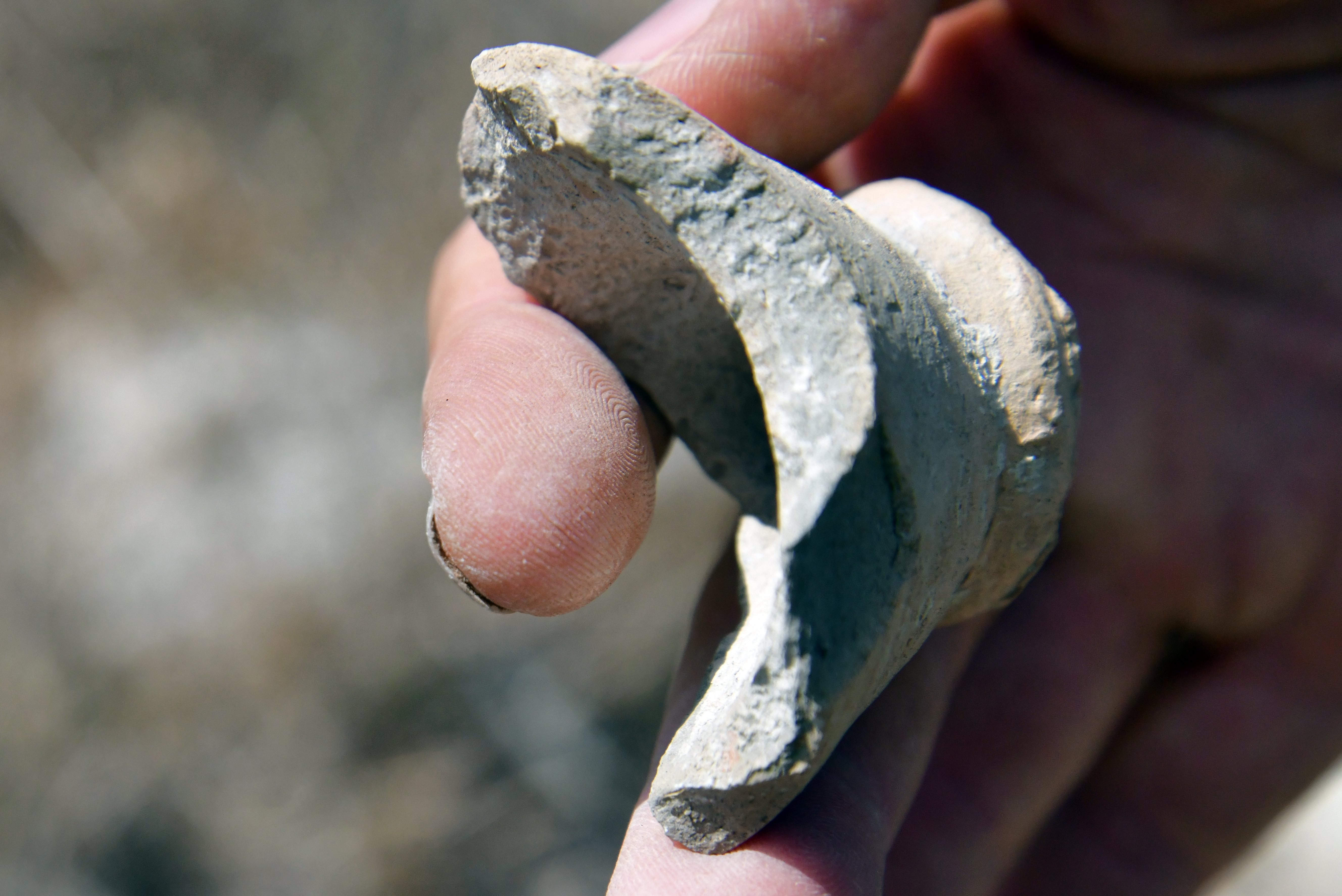
Along the pioneer trail are numerous pottery fragments visible on the hillside above the trail. We dated a few to the Bronze/Iron age (top row), Roman/Byzantine period (lower row), Early Roman (lower right) and Mameluke/Ottoman (left).
Below are closer views of these ceramics, and other samples, that we collected along the trail. All items are left on the site.
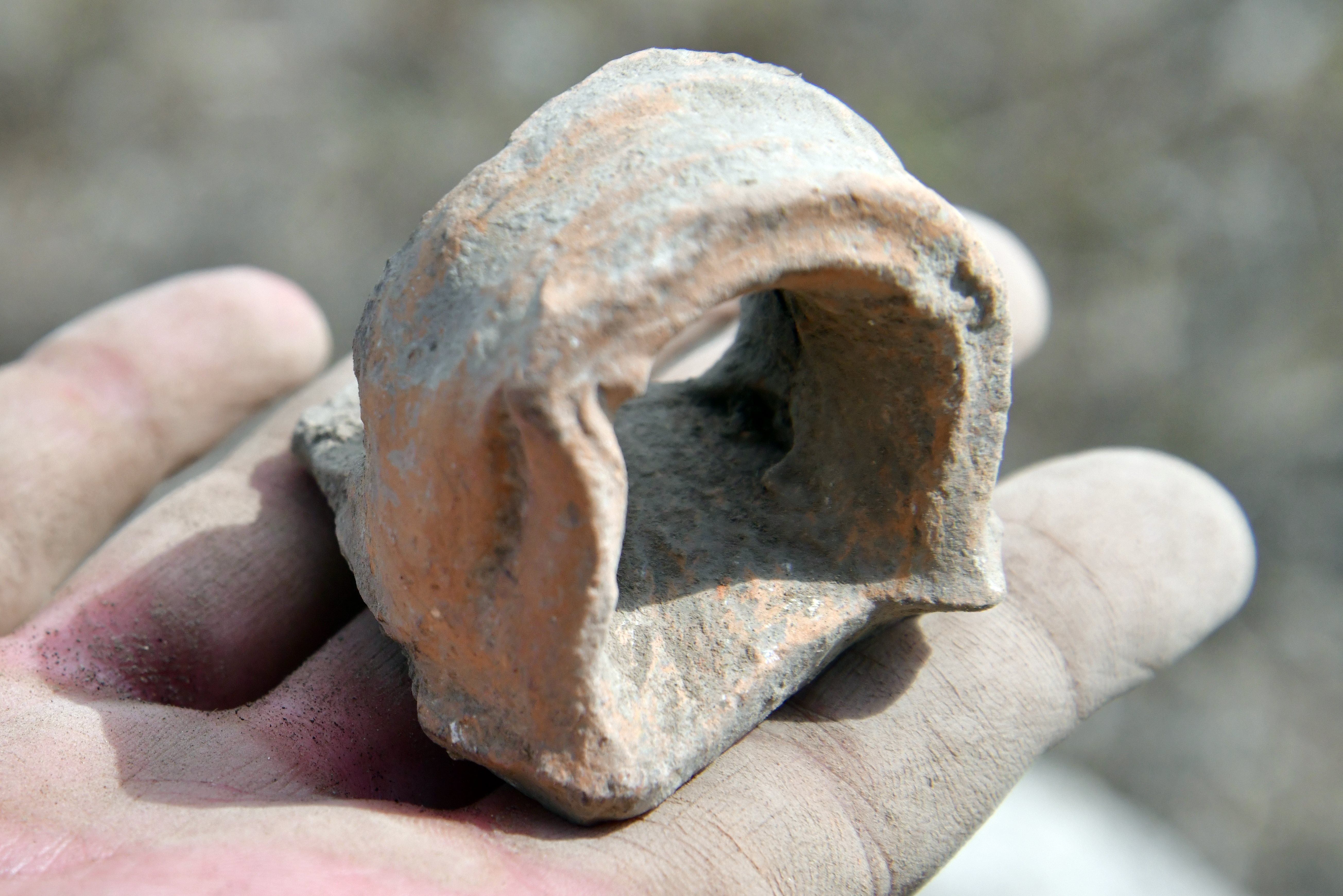
A handle – dated to the Bronze/Iron age:
Byzantine period handle:
Roman/Byzantine fragment of a vessel:
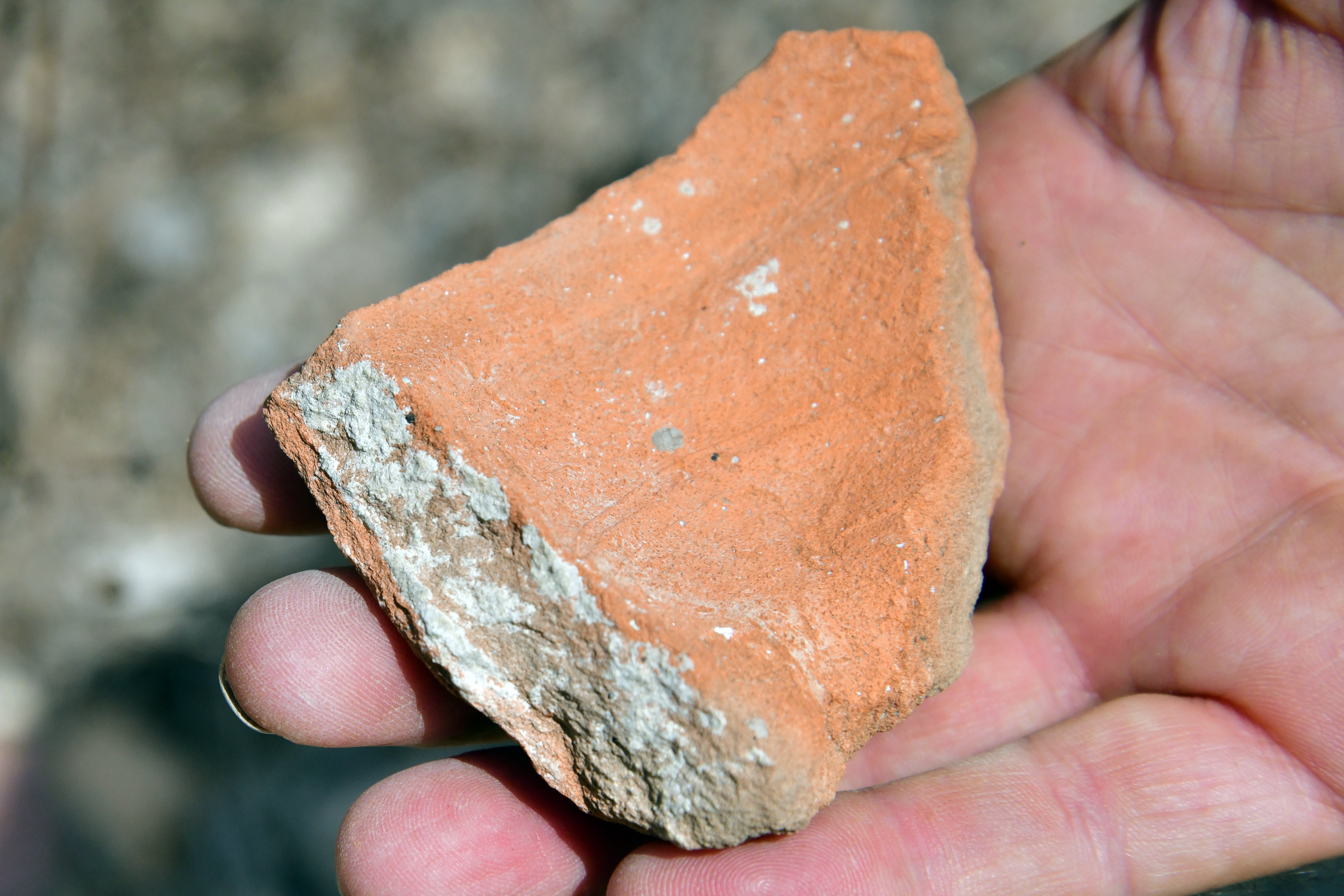
A fine polished rim, dated to the Early Roman period:
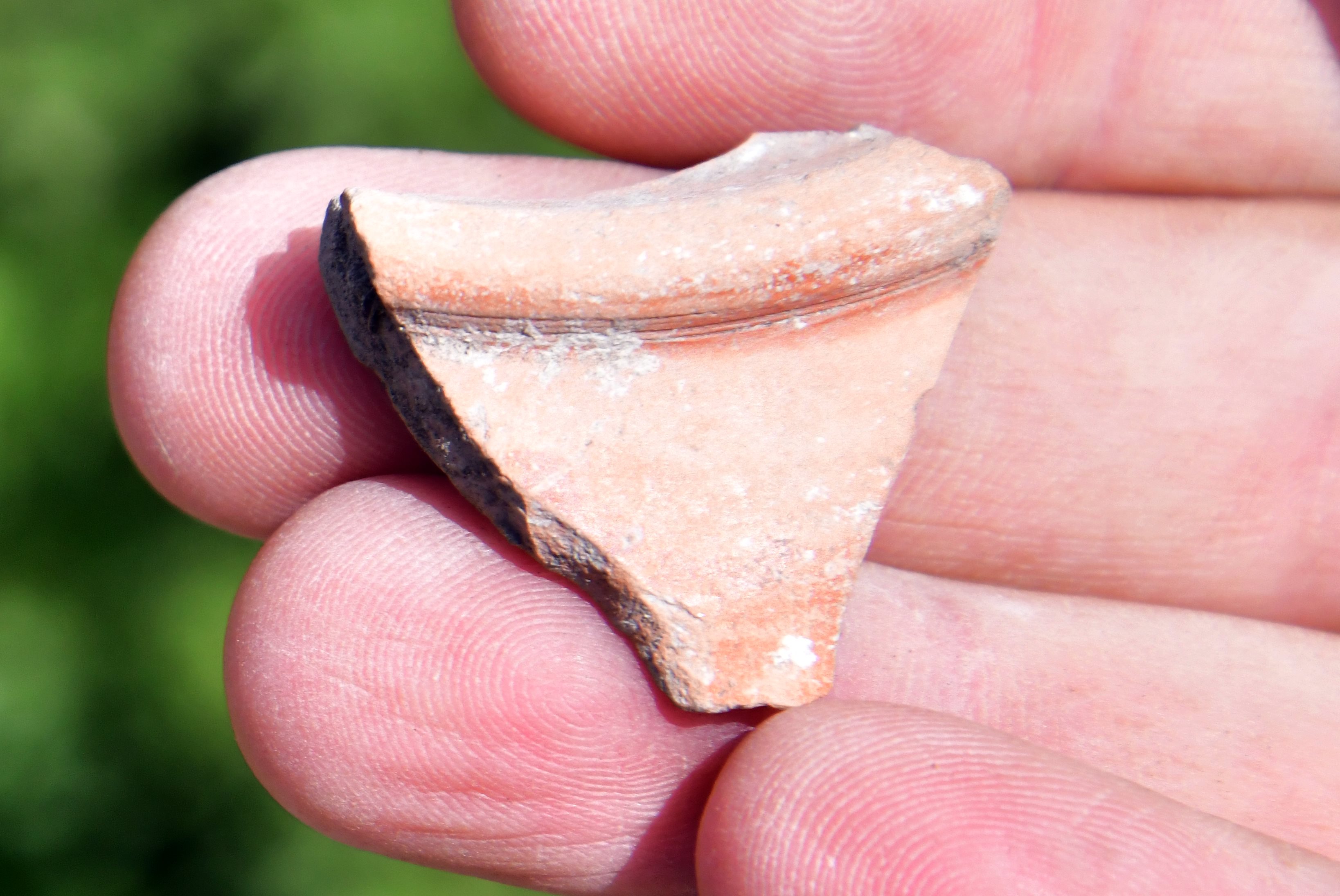
Hellenistic period pitcher:
(d) West Side – entrance road:
The modern paved access road, that ascends from the park’s gate to the top of the hill, was cut along the western side. The historic layers are visible all along the side of the hill. Many ceramic parts are seen along the cut side. A section of a wall of an ancient cave is also seen here on the left.
We searched along the foothill for ancient pottery remains that are stuck in the cut hillside. Most of the pottery fragments were dated to the Iron and Persian period. These are the earlier layers of the city.
We found this specimen – a complete base of a vessel dated to the Bronze/Iron period.
(e) North side – a stone quarry:
The following photo shows the ancient stone quarry near the site, on the northern side. The ancient quarry covers an area of 16 x 92m, and produced ~20,000 slabs.
The quarry was dated to the Hellenistic and Early Roman period. The stones were cut out off the hillside, then used as building material for the coastal city of Dor and for the site on top of the hill. The ancient road continued at the side of the quarry, connecting along the east bank of Nahal Damun to Khirbet Damun.
In the stone quarry remained a broken element of an oil press, that was prepared at the site.
(f) North East Side:
Nearby, looking over the valley, there is a tomb cut into the stone. The stone wall in this site raises up from the valley almost vertically, and is a favorite place for rappelling, as can be seen in the next photos.
The wall drops vertically into the valley, and the rappelling rope is visible on the cliff.
The valley is all covered by Pine (Oren) trees, hence the name of the valley. This photo was taken in the direction upstream (east).
The excavation team also suggested that in ancient times an impressive engineering project was conducted here on the side of the cliff, constructing a trail that established an improved water supply from Oren spring (1 km to the east).
A winepress installation floor was cut on a lower ground below the cliff.
(g) North East side – Oren Valley:
Ruins of a water powered mill are located in the Oren valley, on the north east side of Horvat Oren.
The water that powered the mill was brought via a 0.5km long aqueduct.
The source of the water was from the Alon spring. A pump house was built in the 20th century to raise the water to the settlements in the vicinity.
Etymology (behind the name):
- “Oren” is Pine tree in Hebrew
- Beit Oren – Hebrew: “House of the pine”; A kibbutz that was founded in 1939
- “Khirbet” is a ruined village in Arabic, Horvat in Hebrew
- “Shalale” – The name of the site in Arabic, and means: spring, water source, water falls. The water mill down the stream was called by this name.
- City of the Carmel – possible name during the Roman period
- Ya’arot HaCarmel – Carmel forests, old name of the park offices
- Mishmar HaCarmel (Carmel Guard) – new name of the park office on the site
Links:
* This site:
- Late Roman period ring found on Kh. Shalaleh – (July 2024)
- Pioneers trail – a new nature trail, based on a Roman trail, crosses the site, commemorating Asaf Ramon (Hebrew article).
- Uncovering Ir Carmel at Khirbet Shalaleh – S. Dar, Y. Ben-Ephraim, Qadmoniot 159 (2020), pp 52-58
- Shallale, Ancient city of the Carmel – S. Dar, Y. Ben-Ephraim, Book 2009
- Pliniy the Elder – natural history Full text; Book V chapter 17
* Prehistoric sites:
* Other:
- Oil production and presses
- Quadcopter Aerial views – collection of Biblical sites from the air
- BibleWalks – extreme sports – reppelling
- Byzantine monks
BibleWalks.com – walk with us through the sites of the Holy Land
Khirbet Dubbah <<<—previous site —-<<<All Sites>>>—next Carmel site—>>> Oren Caves
This page was last updated on Oct 15, 2024 (add new photos)
Sponsored links: