Kh. Harithiya is a large Hellenistic and Roman period city, located near Kibbutz Shaar Ha’amakim It is identified as “Geva” or “Gaba”.

Home > Sites > Lower Galilee > Kh. Harithiya (Gaba, Geva Parashim)
Contents:
Background:
Khirbet Harithiya was a large city in the Hellenistic and Roman periods. The site is identified as “Geva Parashim” or “Gaba” or “City of Horsemen”, based on Josephus Flavius ‘s description.
Josephus Flavius (Wars 3: Chapter 3: 1): “Gaba, which is called the City of Horsemen, because those horsemen that were dismissed by Herod the king dwelt therein;”
Location:
Khirbet Harithiya (Arabic for : “ploughed land”) is located near Kibbutz Sha’ar Ha’amakim (“the gate to the valleys”).
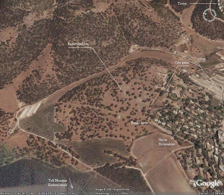
This aerial map provides a close up on the main area of Khirbet Harithiya, on the north-west side of the Kibbutz. The site is located on a hill (100M), surrounded by valleys on 3 sides. As seen on the photo, there are traces of ancient walls around the site. The road from the south side entered through the city gates, and traces of them can be seen at that point.
History:
-
Earlier period in Tell el-Amar
The city first started in the late Bronze period in Tell Meamer (el-Amar), located 1.5KM to the east, just behind the Kishon river. The city is identified as “Geva Shemanim”. Later, the city on the Tell gradually became a minor site and finally abandoned, since it was too small for the larger population.
-
Establishment
The new city was established during the Hellenistic period on the hills east of the Tell, in Khirbet Hartiya. It first started as a farm in the Persian period, grew, then finally replaced the old city. In recent years large structures from the Hellenistic period were excavated – see photos below.
Note that there are debates among scholars on the location of Geva during the Hellenistic period. Some rely on Josephus description, which makes Khirbet Harithiya the best candidate. However, there are other opinions – check the references.
-
Roman period
The new site continued to grow in the Roman period. The new city was the place where King Herod resettled his retired Horsemen. It is called also as Geva-Parashim (the latter means “horsemen”). It is described by Josephus Flavius (see below). The city was probably given to him by Augustus in 30 BC after his victory over Marc Anthony and Cleopatra, in addition to Jaffa and other coastal cities.
In the Jewish revolt (summer of 66) the Jewish mob attacked the Roman military unit in the city.
-
Later Periods
The city continued until the early Arabic period (6-7C AD), then it started to decline. Some parts of the city continued to be populated until recent times.
-
Ottoman period – PEF survey
The area around the valley was examined in the Palestine Exploration Foundation (PEF) survey (1866-1877) by Wilson, Conder and Kitchener. This area appears in the center of the section of the map of 1878 (below). As seen, the site is located on crossroads of ancient highways: an east going road (marked by a double dashed line) traverses the site on the way to Nazareth and beyond. Another road connects North via Acre, to South via Yokneam. These gave the site a strategic importance.
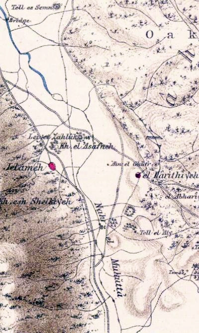
Part of Map Sheet 5 of Survey of Western Palestine,
by Conder and Kitchener, 1872-1877.
(Published 1880, reprinted by LifeintheHolyLand.com)
The sites marked on this map include the following points of interest-
“el Harithiyeh – A miserable hamlet of mud, on high ground, with an open plateau to the east and a spring below on the west (‘Ain el Ghafr). The population in 1859 is stated by Consul Rogers at 120 souls, and the village at twelve feddans. This place has been supposed to be the ancient Harosheth of the Gentiles from the identity of name (Judges iv. 2). The position is not an impossible one. Guerin proposes this place as the site of Josephus’s Besara (Life iv 24), which was twenty miles from Gaba. He places Gaba at Sheikh Abreik”.
“Tell ‘Amr (or Leiyet Zahluk) – A large artificial mound with stones on it”.
“Kh. el ‘Asafneh – Heaps of stones”.
“Kh. Jelameh Heap of stones and cisterns”. [Arabic meaning: “ruin of the hill”].
- WW1:
During the World war I (1916-7) the Turks had an army base that dug into the hills of Harithiya, since they anticipated that the British will advance through the Kishon valley just below the site.
-
Modern times
Today Khirbet Harithiya is in ruins. It was excavated by Prof. Arthur Segal of the Haifa University.
South-east to it is Kibbutz of Sha’ar Ha’amakim, established in 1935 by Zionist pioneers from Yugoslavia.
Photos:
(a) Aerial view
A drone view from the east side of the site is seen below. The ruins of the site are scattered on the hill, with a small section excavated in the center.
In the left background is Mt Carmel, with the Biblical mound of Tell Mea’mer in front its foothills.
Click on the photos to view in higher resolution…

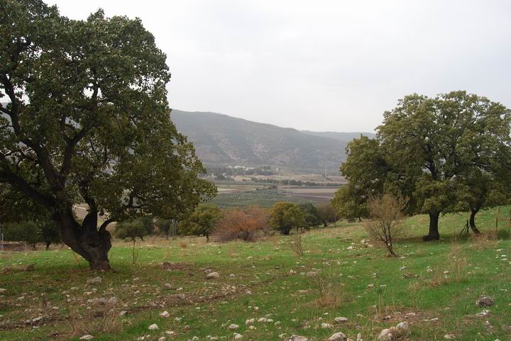
(b) General view
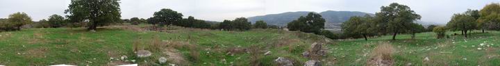
The photo below, towards the west, shows the area of Khirbet Harittiya, which is in ruins and buried under the hillside among the oak trees. In the far background is the northern slopes of Mount Carmel, and in the near background is Tell Meamar (el-Amar), which predated the site.
A view towards the south shows the west side of Kibbutz Sha’ar Haamakim. Some parts of the ancient site are buried under the houses on that southern side.
A wide panoramic picture of the area around the site is seen in the photo below.
Click on the photos to view in higher resolution…
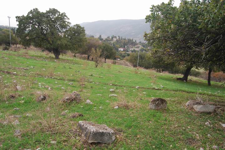
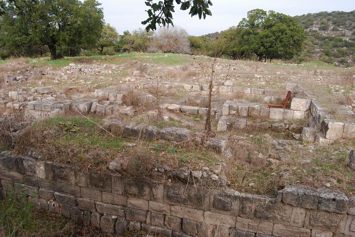
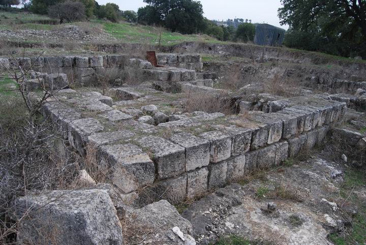
(c) The excavated area – South side
The next photos show the site from the south side. The excavation unearthed a Hellenistic structure on a hill on the north-west side of the Kibbutz.
*** The information is preliminary – we will add more data on this excavation.
Another view towards the north-east.
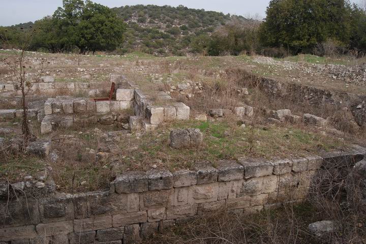
A view from the west side towards the north-east.
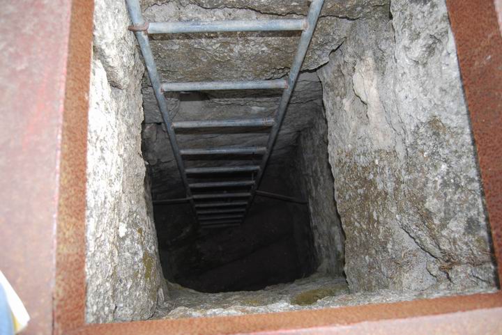
(d) The excavated area – Center
Stairs lead down to a pit located under the structure, under the rusting cover that is seen in the upper photo.
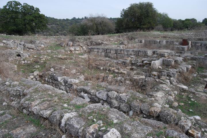
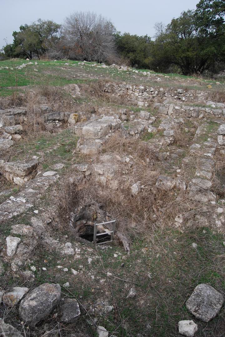
(e) The excavated area – West side
A view towards the west. A second hole and ladder is located at this point.
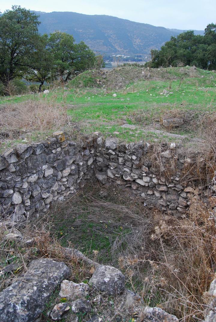
Another view towards the west.

The south-west corner of the excavation, with a view of Mount Carmel in the background.
Historical References:
(a) Josephus Flavius (Wars 3: Chapter 3: 1)
In this text the Historian (ex-commander of the Galilean Jews against the Romans) describes the new city of Geva (Gaba) which is where King Herod (37BC-4BC) resettled his retired horsemen.
Now Phoenicia and Syria encompass about the Galilees, which are two, and called the Upper Galilee and the Lower. They are bounded toward the sun-setting, with the borders of the territory belonging to Ptolemais, and by Carmel; which mountain had formerly belonged to the Galileans, but now belonged to the Tyrians; to which mountain adjoins Gaba, which is called the City of Horsemen, because those horsemen that were dismissed by Herod the king dwelt therein; they are bounded on the south with Samaria and Scythopolis, as far as the river Jordan; on the east with Hippeae and Gadaris, and also with Ganlonitis, and the borders of the kingdom of Agrippa; its northern parts are hounded by Tyre, and the country of the Tyrians. As for that Galilee which is called the Lower, it, extends in length from Tiberias to Zabulon, and of the maritime places Ptolemais is its neighbor; its breadth is from the village called Xaloth, which lies in the great plain, as far as Bersabe, from which beginning also is taken the breadth of the Upper Galilee, as far as the village Baca, which divides the land of the Tyrians from it; its length is also from Meloth to Thella, a village near to Jordan.
(b) Josephus Flavius (Wars 2: Chapter 18: 1)
When the Jewish revolt started in 67AD, the Jewish rebels attacked several cities, including Geva (Gaba) where a Roman unit was positioned (as per the next text).
Now the people of Cesarea had slain the Jews that were among them on the very same day and hour [when the soldiers were slain], which one would think must have come to pass by the direction of Providence; insomuch that in one hour’s time above twenty thousand Jews were killed, and all Cesarea was emptied of its Jewish inhabitants; for Florus caught such as ran away, and sent them in bonds to the galleys. Upon which stroke that the Jews received at Cesarea, the whole nation was greatly enraged; so they divided themselves into several parties, and laid waste the villages of the Syrians, and their neighboring cities, Philadelphia, and Sebonitis, and Gerasa, and Pella, and Scythopolis, and after them Gadara, and Hippos; and falling upon Gaulonitis, some cities they destroyed there, and some they set on fire, and then went to Kedasa, belonging to the Tyrians, and to Ptolemais, and to Gaba, and to Cesarea; nor was either Sebaste [Samaria] or Askelon able to oppose the violence with which they were attacked; and when they had burnt these to the ground; they entirely demolished Anthedon and Gaza; many also of the villages that were about every one of those cities were plundered, and an immense slaughter was made of the men who were caught in them.
(c) Josephus Flavius (Life : 24)
In this text the Commander talks about his acts during the preparations to the revolt (66-67AD). In this text he actually describes the range from Gibea (Geva) to Beit-Shearim (Besara) – 20 furlongs (4KM), which is the location of Kh. Harithiya. This is an important identification hint for the site which were used by the scholars.
“Now king Agrippa sent an army to make themselves masters of the citadel of Gamala, and over it Equieulus Modius; but the forces that were sent were not allow to encompass the citadel quite round, but lay before it in the open places, and besieged it. But when Ebutius the decurion, who was intrusted with the government of the great plain, heard that I was at Simonias, a village situated in the confines of Galilee, and was distant from him sixty furlongs, he took a hundred horsemen that were with him by night, and a certain number of footmen, about two hundred, and brought the inhabitants of the city Gibea along with him as auxiliaries, and marched in the night, and came to the village where I abode. Upon this I pitched my camp over against him, which had a great number of forces in it: but Ebutius tried to draw us down into the plain, as greatly depending upon his horsemen; but we would not come down; for when I was satisfied of the advantage that his horse would have if we came down into the plain, while we were all footmen, I resolved to join battle with the enemy where I was. Now Ebutius and his party made a courageous opposition for some time; but when he saw that his horse were useless to him in that place, he retired back to the city Gibea, having lost three of his men in the fight. So I followed him directy with two thousand armed men; and when I was at the city Besara, that lay in the confines of Ptolemais, but twenty furlongs from Gibea, where Ebutius abode, I placed my armed men on the outside of the village, and gave orders that they should guard the passes with great care, that the enemy might not disturb us until we should have carried off the corn, a great quantity of which lay there: it belonged to Bernice the queen, and had been gathered together out of the neighboring villages into Besara; so I loaded my camels and asses, a great number of which I had brought along with me, and sent the corn into Galilee. When I had done this, I offered Ebutius battle; but when he would not accept of the offer, for he was terrified at our readiness and courage, I altered my route, and marched towards Neopolitanus, because I had heard that the country about Tiberias was laid waste by him. This Neopolitanus was captain of a troop of horse, and had the custody of Scythopolis intrusted to his care by the enemy; and when I had hindered him from doing any further mischief to Tiberias, I set myself to make provision for the affairs of Galilee”.
Etymology (behind the name):
- Geva – In Hebrew its a short form of the word “hill”. There were other places with this name. This is why there is a prefix : Geva-Shemen and Geva-Parashim.
- Khirbet Harithiya (Geva; Geva-Parashim):
- Name in the survey of Western Palestine (1881): El Harithiyeh
Arabic for “the ploughed land”.
- Name from the British Mandate map (1940): Kh. el Harithiya
- Also called Geva-Parashim (Hebrew for “horsemen”), since Herod resetlled his retired horsemen in this city.
- Kibbutz Shaar Haamakim – the name means in Hebrew “the gate to the valleys” – the valleys are Jezreel and valley of west Galilee.
- Kiryat Harosheth – “Kiryah” is in Hebrew: city or suburb. “Harosheth” is in Hebrew: industry. It is called after the area “Harosheth of the Gentiles” described in the Biblical battle of Barak and Sisera (Judges 4,5).
Archaeological References:
-
Arch. Survey of Israel – Nahalal Map (28) – Avner Raban [1982] , site #4, #5 (Kh. Harithiya)
-
Carta’s Atlas of the 2nd Temple Period – M.Avi-Yonah [Carta Jerusalem 1966] – Shop for this must-have book.
Site: Kh. Harithiya Maps: 60, 68, 75, 83, 84, 92, 104, 107, 159
-
“Four Seasons of Excavations at the Hellenistic Site at Shaar HaAmakim”, Qadmoniot 81-82 (1988), pp. 24-30. [Hebrew]. Prof Arthur Segal, Univ of Haifa – the excavator in Harithiya.
-
Geva in the Hasmonai period (Hebrew) – [ Z. Safrai, M. Lin] this article identifies Geva in an alternative site – Tell Abu-Shusha (Shush) near Mishmar Haemek
Other ancient sites close to Geva:
- Tell Meamar (el-Amar) – the ancient city before Harithiya, identified as Geva-Shemen; 1.5KM west
- Tell Yokneam – located 7Km to the south. According to the Bible, Yokneam was part
- Tell Kassis – located 5KM to the south. Identified as Biblical Khelkat.
- Beit Sharim – located 3-4KM to the south-east, and was a large ancient city, including a famous necropolis (with tombs buried inside caves).
Other Links:
- Drone Aerial views – collection of Biblical sites from the air
BibleWalks.com – walk with us through the sites of the Holy Land
Geva <<<—previous site—<<<All Sites>>>—next lower Galilee site—>>>T. Hannathon
This page was last updated on June 19, 2015 (Added aerial view, reformat, add PEF report)
Sponsored links: