Newly discovered Iron Age II period desert fortress east of Yeruham.
Home > Sites > Negev> Yeruham> Nahal Avnon fortress
Contents:
Background
Location
History
Photos
Videos
Etymology
Links
Overview:
Recent excavations unearthed an unkown Iron Age IIa desert fortress inside the city of Yeruham, on the north bank of Nahal Avnon.
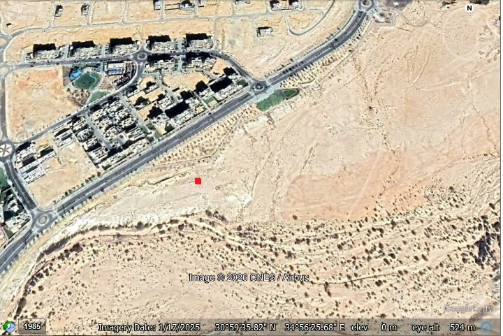
Location and Map:
The site is located inside the city of Yeruham, north west of the Industrial area. It is marked as a red square, adjacent to a new neighborhood.
History:
As the modern city of Yeruham expanded, it revealed a hidden piece of ancient history: an Iron Age II fortress perched on the north bank of Nahal Avnon. This isn’t an isolated outpost; it’s part of a strategic chain of Judean Kingdom sites stretching across the central Negev. Some of these Iron Age sites were already reviewed in BibleWalks: Mt. Eldad fort, Horvat Ritma, Ramat Boker, Horvat Halukim.
- Biblical periods – “way of the Atharim”
Scholars believe these forts guarded the ‘Way of the Atharim’—the same major north-south artery mentioned in the Bible. This legendary route ascended from the Arava Valley through the Ramon Crater, cutting through these highlands near Sde Boker and Yeruham on its way to Tel Arad.
We find its first mention in Numbers 21:1, which describes the King of Arad hearing that Israel was approaching along the ‘Road to Atharim.’ “When the Canaanite king of Arad, who lived in the Negev, heard that Israel was coming along the road to Atharim, he attacked the Israelites and captured some of them.” He launched a strike here, marking one of the first organized military resistances the Israelites faced on their journey to the Promised Land.
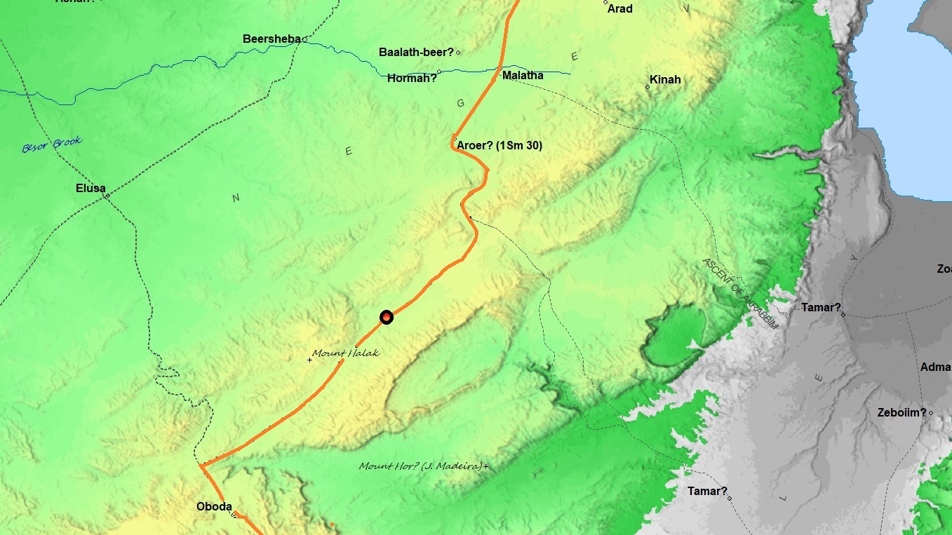
Way of the Atharim (based on Bible Mapper 3.0)
The word “Atharim” (הָאֲתָרִים) is a “hapax legomenon”—a term that appears only once in the entire Hebrew Bible. Because of its uniqueness, scholars and theologians have proposed several explanations for its meaning.
1. The Linguistic/Functional View: “The Way of the Spies”
This is the most traditional interpretation, favored by the King James Version and ancient Aramaic translations like Targum Onkelos.
-
-
The Root: It derives from the Hebrew root Tayar (תור), meaning to scout or spy.
-
The Logic: Proponents believe the word was slightly altered over time or represents an archaic form. Under this view, the Israelites were retracing the path of the twelve spies sent out by Moses decades earlier. The King of Arad, hearing they were on the “Scouts’ Road,” knew exactly which mountain passes to defend.
-
2. The Geographic View: “The Way of the Tracks”
Many modern historical geographers, including Yohanan Aharoni, look to related Semitic languages for a solution.
-
-
The Root: In Arabic, the word Athar means a “trace,” “footprint,” or “track.”
-
The Logic: This suggests the route was named the “Way of the Tracks” or “The Well-Beaten Path.” This implies it was a prominent, ancient caravan trail that had been etched into the desert floor by centuries of use before the Israelites ever arrived.
-
3. The Archaeological View: “The Way of the Sites”
This interpretation is based on the modern Hebrew word Atar (אתר), meaning a “site” or “location.”
-
-
The Root: Pluralizing Atar gives you Atharim.
-
The Logic: The route may have been named for the series of established Middle Bronze Age sites or settlements it passed through. As you’ve noted in your survey, the Negev is dotted with ancient fortresses and water points; this name would literally mean “The Road of the Settlements,” identifying it as a major artery connecting known hubs of human activity.
-
4. Effect of the death of Aharon:
Another interpretation of this event was that the King of Arad heard that Aharon the high priest has just died (as per previous chapter, Numbers 20:22-29), and assumed that the Israelites are now weak due to the lost connection with their God, and so he siezed the opportunity to attack them.
5. The Proper Noun View: “The Place Named Atharim”
Some scholars argue that Atharim is simply the specific proper name of a location that has since been lost to history.
- Iron Age IIa – The fortified enclosures during the United Monarchy
Fast forward about 300 years to the 10th century BC, and this desert route was formalized with permanent defenses. During the period of the United Monarchy, the Central Negev Highlands experienced a surge of rapid and widespread settlement. This rugged landscape—bounded by the Nahal Zin cliffs, the Machtesh Ramon crater, and the Kadesh Barnea oasis—became home to dozens of unique structures that continue to spark debate among historians today.
Archaeologists have identified and surveyed approximately 50 fortified enclosures, often termed “fortresses.” Near this site, just a few kilometers to the north, are additional Iron Age fortresses – Givat Refed and Hatira fortress. There are more Iron Age IIa fortresses in Nahal Boker area to the south of this site. Several of those are reviewed in BibleWalks.com: Ritma, Ramat Boker, Halukim, Mt. Eldad.
Key characteristics of these sites include:
- Location: Built on hilltops within sight of one another, usually near wadi beds or water sources.
- Architecture: Most range from 25–70 meters in diameter, with shapes (circular, oval, or triangular) dictated by the natural contour of the hill.
- Layout: They typically feature casemate walls (double walls divided into rooms) surrounding a large central courtyard accessed via a narrow entrance.
Excavations near these fortresses have uncovered groups of dwellings, suggesting the sites served as hubs for larger communities. Interestingly, the pottery found at these locations tells a story of two distinct cultures:
- Wheel-made Pottery: Identical to shards found throughout Judah, dating to the United Monarchy.
- Negbite Ware: Crude, handmade pottery created by local nomadic groups.
- Who built these structures, and why?
The origin of these enclosures is one of the most contested topics in Levantine archaeology. Here are some concepts: (a) I. Finkelstein suggests that these weren’t fortresses, but sedentary structures built by Amalecites or the Tribe of Simeon, similar to modern Bedouin animal pens. (b) Y. Aharoni considered that they represent a gradual Israelite penetration into the Negev during the 11th century BC (Iron Age I). (c) Z. Meshel/R. Cohen suggested that these were administrative centers built by Saul or Solomon to protect the frontier against desert nomads.
- The site at Nahal Avnon
The site we’re looking at covers roughly 30 by 55 meters (estimated). The Avnon fortress is one of the largest of the Negev fortreses. Its design is a classic Iron Age layout: a central courtyard surrounded by casemate chambers—double walls with rooms built right into the fortifications. While only the northeast corner has been excavated so far, it’s enough to show us that this wasn’t just a camp; it was a high-stakes border crossing between the desert and the heart of the kingdom.”
The excavators also unearthed pottery, flintstone tools, and animal bones of goats and sheep. They dated the fortress to the Iron Age IIa (1000-925 BC).
- Destruction
It is likely that the site was destroyed during the Egyptian invasion of Shishak (926 BC), who swept through the kingdom of Judah as reported by the Bible.
After the split of the Unified Kingdom, Shishak invaded the land of Israel and captured Aroer as well as other fortified Judean cities. Shishak (also known as Sheshonk I) was an Egyptian pharaoh who ruled from 945-924 BC. He is known for his military campaigns in the Near East, including his invasion of Israel in 925 BC. The Bible wrote about this campaign (1 Kings 11:40; 14:25-26; 2 Chronicles 12:2-9). These verses are from 2 Chronicles 12:2-4:
“And it came to pass, that in the fifth year of king Rehoboam Shishak king of Egypt came up against Jerusalem, because they had transgressed against the LORD, With twelve hundred chariots, and threescore thousand horsemen: and the people were without number that came with him out of Egypt; the Lubims, the Sukkiims, and the Ethiopians. And he took the fenced cities which pertained to Judah, and came to Jerusalem”.
In this relief on the wall of the Great Temple at Karnak, the pharaoh listed the places he conquered in his campaign. The conquest of Tel Yeruham appears on a wall in his palace in Upper Egypt, and the name appears as Y-r-h-m.

Karnak: Commemoration of Shishak’s victory over Rehoboam
Photo of the Library of congress (American Colony, taken 1900-1920)
Photos:
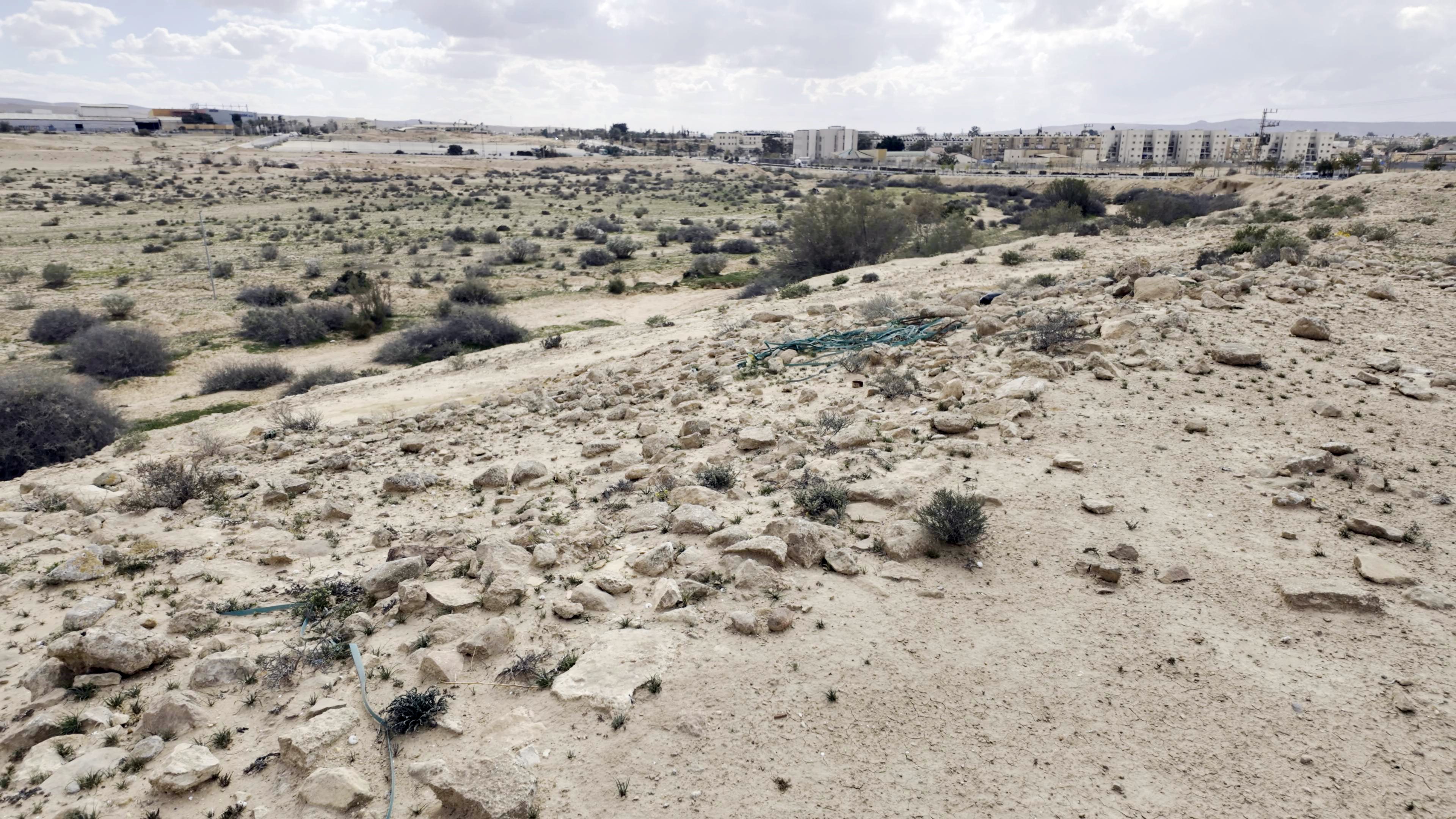
- North bank of Nahal Avnon
The fortress was built along the north bank of Nahal Avnon that crosses the modern city of Yeruham. This creek flows from Mt. Avnon, on the edge of the great crater, to Nahal Revivim, a source of Nahal HaBasor.
Click on the photos to view in higher resolution…
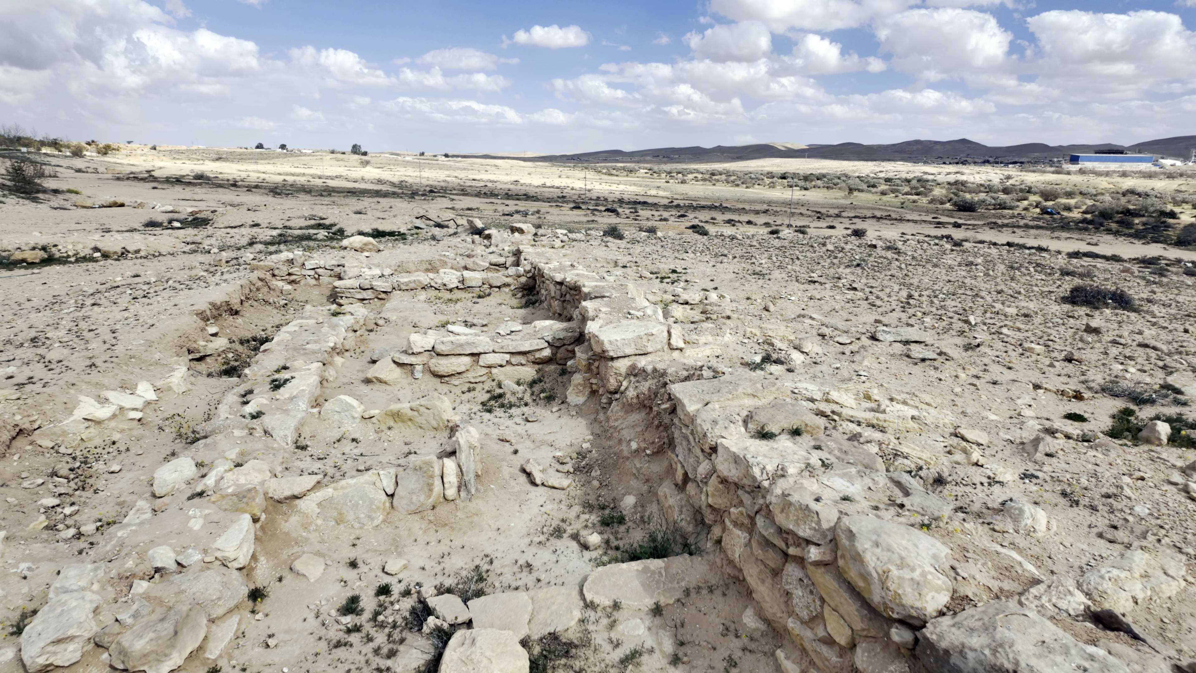
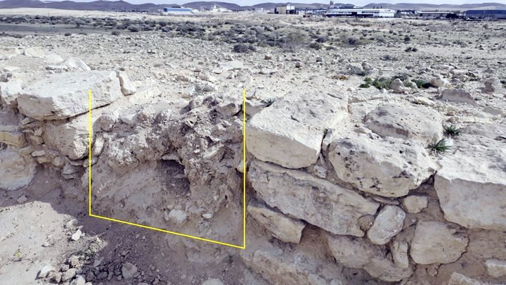
- North east corner
Recent excavations revealed the north east corner of the fortress, which incorporated a casemate wall. A casemate wall is ancient fortification system consisting of two parallel, longitudinal walls (one outer and one inner) connected at regular intervals by short, perpendicular walls. It is a common plan of fortified places, characteristic of the Iron Age period.
Here is an illustration made on the basis of this site:
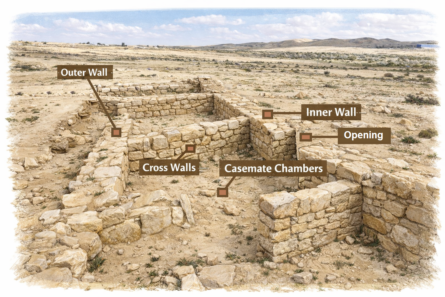
Illustration of casemate wall (Image created by AI using OpenAI’s ChatGPT)
Below is a view towards the north east. One wall is the inner wall (55cm wide), while the second is the outer wall (60cm wide). The two parallel walls have a 2m separation between the walls. A perpendicular wall, 200 cm long and 50 cm wide, divided the area into 2 chambers.
The floor of the chamber was paved with large flat slabs, although only few survived.
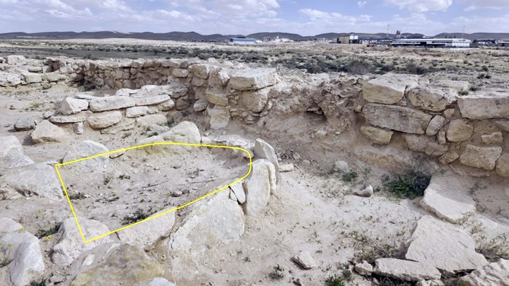
Inside the first chamber is a small installation, perhaps a ritual altar based on the burnt stones and bones found between the standing stones. Beyond the separation wall is a second chamber.
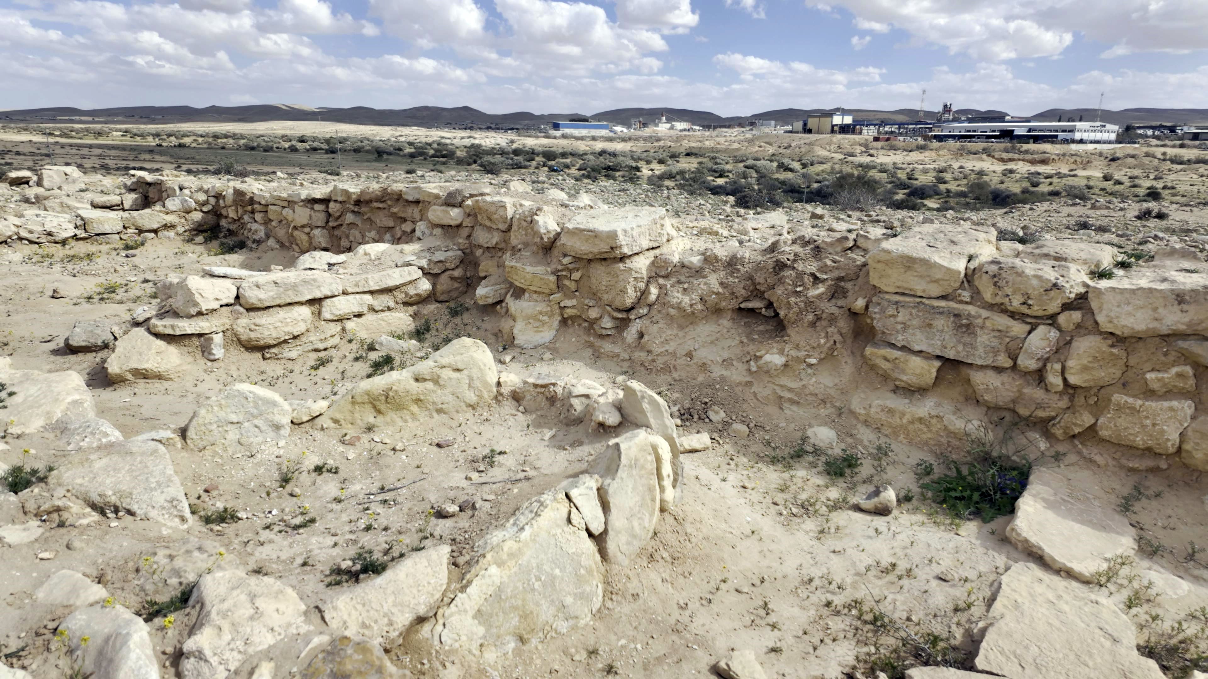
The altar is marked below with a yellow line. It is 90cm by 90cm and is attached to the outer wall. It was built upon a foundation of a raised pressed ground (25cm high) and is surrounded by standing slabs (30cm by 50cm). On the top was a layer of ash (20cm wide) with medium sized burnt stones, few pottery sherds and burnt bones.
The walls are made of two rows of medium sized roughly cut stones, filled with small fieldstones.
An opening, 1m wide, provided access to the courtyard.
On both side of the opening are doorposts.
The opening is marked here with yellow lines:
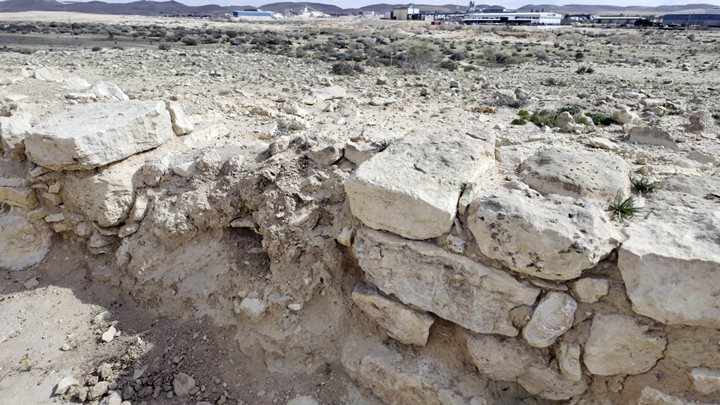
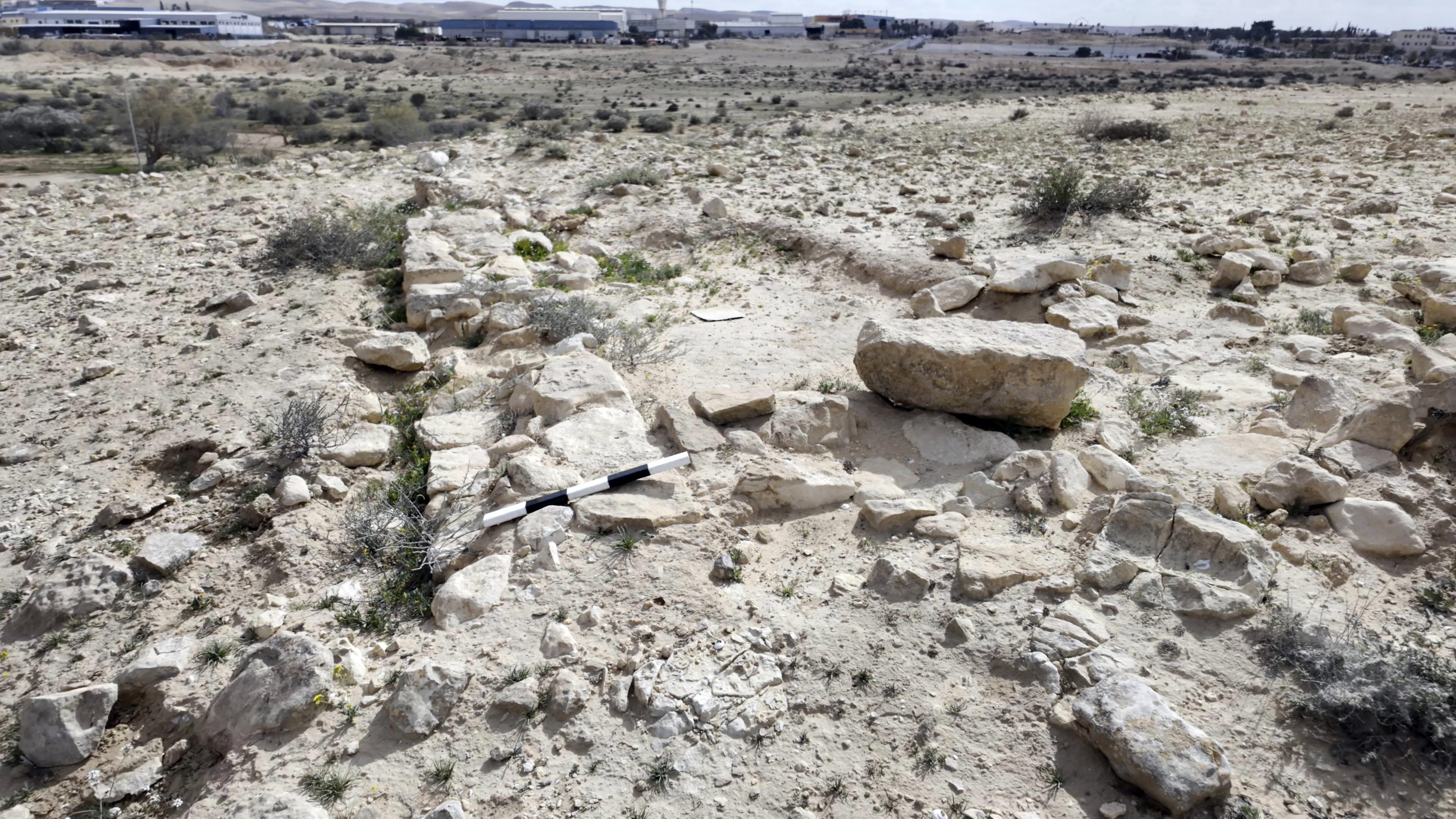
- Eastern wall:
Another section of the casemate wall was unearthed on the corner of the northern wall.
The outer wall is also 60cm wide. The inner wall is bearly seen on the right.
Videos:
A visit to the site was recorded in Februray 2026:
Etymology (behind the name):
* Names of the area:
- Yeruham – the town was established in 1951. The name is derived from the Hebrew root R-H-M (ר-ח-ם), means “mercy,” “compassion,” or “to cherish.” Before the modern town was founded, the area was known by the Arabic name Bir Rakhma, meaning “Well of Mercy.” It is located north east of the Lake’s park area. Local tradition identifies this ancient well as the one revealed by God to Hagar when she was wandering in the desert with her son Ishmael (Genesis 21)
- Tel Yeruham – – an Iron Age site on the west side of the town.
- Khirbet A-Rakhma – Arab name of Tel Yeruham, an ancient mound north of Yeruham. In Arabic: the ruins of mercy.
- Qasr Rekhmeh – the Arabic name of the site (means: fortress of mercy)
Links and References:
* External links:
- Yeroham, Nahal Avnon Fortress – HAESI 136 2024 – final report Sa‘ar Ganor, Shifra Weiss and Ahinoam Montagu
- Nahal Avnon trial excavation – HAESI Volume 133 Year 2021 – Lauren Wendy Davis
* Internal links:
- Yeruham – overview of sites around the city
- Negev Iron Age forts – overview of Iron Age fortresses
- Har Yeruham – prehistoric sites on the hill south of the lake
- The Nabateans – info page
- Map of Nabatean sites in Israel
![]()
BibleWalks.com – Exploring the Negev Iron age fortresses
Yeruham fortress <—previous Negev site—<<<All Sites>>>—next Negev site —> Yeruham overview
This page was last updated on Mar 15, 2026 (historic background)
Sponsored links: