Horvat Gedora is located on the side of the coastal section of the ancient Via Maris road, south of Afek. It was inhabited from the Bronze period through the Byzantine period.
Home > Sites > West Galilee >Horvat Gedora (Khirbet Jidru)
Contents:
Background
Location
History
Photos
* General views
* Pottery dating
* Rhodian amphora
* Purple Dye
* Nature
* Sculpture
Etymology
Links
Background:
The site is located on the side of the ancient road of Via Maris (Derech Hayam), the major highway that connected for centuries the south and the north of Israel. (Isaiah 9,1): “…the way of the sea… in Galilee of the nations”. Gedora was one of the sites along this ancient road. According to archaeological survey, the majority of the findings are from the Israelite period through the Byzantine period. Today the site is in ruins and was badly damaged. A new highway was built on its eastern side, and the 2007 emergency excavations may have found a section of the ancient road.
The Arabic name of the site, Khirbet Jidru, gave the valley of Zevulun its Arabic name – Jidru.
Location:
The site is located in the plains south to Afek and Acre (Akko), on the east side of the modern agriculture village of Kefar Bialik. It is easily accessed from the industrial area that surrounds the site. The hill covers an area of 100 by 250m, rising 6m above the surroundings.
History of the place:
Archaeological surveys have found remains from several periods, including the Bronze Age, Iron Age (Israelite period), Persian, and especially during the Hellenistic periods.
-
Bronze period
Archaeological surveys (1952, 1958) dated the earlier periods in the site to the Middle Bronze period II (2000-1550 BC).
-
Biblical, Hellenistic periods
The site continued through the Late Canaanite period (1550 BC – 1200 BC), the Israelite and Persian period (1200-332 BC). It peaked at the Hellenistic period (332BC – 37 century BC), probably as a Phoenician site under the Seleucid Kingdom ruled from Tyre.
A Biblical map of the area shows the position of the city (Gedora). It lies on the side of the road from the coast of Mt Carmel, via Tell Abu-Huwam (a harbour, on the banks of the Kishon River), to the north (Aphek and Acco). This map shows that another road connected Aphek to Jokneam pass.
Map of area around the site (yellow square) – from the Canaanite thru the Roman periods (based on Bible Mapper 3.0)
Via Maris (“Derech Hayam” – the way of the sea) was the major highway that for centuries connected the center and south of the Holy Land (Egypt and Africa) – to its north and beyond (Syria, Mesopotamia and Asia Minor). This trade road was the spine of the fertile crescent. The road had two Galilee branches – the western (coastal) branch which passes at Tel Gedora, and the eastern branch that passes through the Sea of Galilee.
David Dorsey (“The roads and Highways of Ancient Israel”, 2018, p. 79, Map 3) marked the main Bronze/Iron age highway thru this site as “I1”, connecting it to Tel Regev then Geva Shemen. Another fork was “I27” connecting thru Tel Nahal and Tel el Idham to the port of Tell Abu-Huwam (east of Haifa, at the crossing of the Kishon river). Both roads then converged after passing mount Carmel, about 30KM south, and continued along the coast through the heart of Israel towards Egypt.
Tel Gedora was one of the sites along the south-western road. In the map below you can see how dense the sites were along the ancient coastal road: there was a site almost every Kilometer, and the location of the sites was selected due to their proximity to the road, the natural higher ground (a hill) and close to source of water (wells). The map also shows the estimated location of these roads that split somewhere near Horvat Gedora.
Map of area of the bay area – from the Canaanite thru the Roman periods (based on Bible Mapper 3.0)
According to recent excavations, the shore was much closer to the site in antiquity than it is today. Over the years sand accumulated in the bay of Haifa, receding the shoreline.
- Roman/Byzantine periods
The site continued as a smaller village through the Roman and Byzantine periods (1st century BC thru 6th century AD). The site was ruined in the Arab period (7th century) and remained in ruins since then.
A possible reference to Gedora is in 3rd century Talmud Yerushalmi (Ma’asarot, aleph, aleph) where “Carobs of Gdira” are listed among other fruits of trees.
- Roman Roads:
The Romans perfected the art of road building, and enabled them to effectively manage the vast empire by improving the links between the cities, especially for military purposes. The Peutinger map (Peutingeriana tabula) of the 4th century Imperial Roman roads shows the coastal way from Acre (“Ptolemaide” in the top center) through Dor (“Thora”) to Caesarea Maritama (“Cesaria” on the top left). The position of the site is shown on the map, close to the Kishon river.
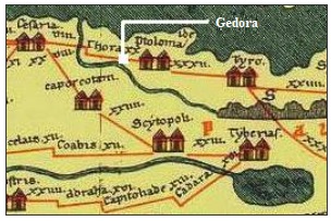
The split of the Roman road was probably at Gedora. The choice of Gedora as a splitting point is based on the topography and is enforced by the fact that its name, “Gedro”, is written as a landmark in a Roman milestone in Nahariyah. A large Roman stone tablet was found near the Roman road in Nahariyah. It has the following inscription:
” IMP[ERATOR] NER[ONI] CAESARI COL[ONIA] PTOL[EMAIS] VETER[ANORUM] VICI NEA COM[E] ET GEDRO”.
The tablet is dedicated to Nero Caesar (54-68AD), by the Roman veterans in the Acre Colony (Col Ptolemais). It indicates the road connected two towns: “New village” (maybe Shavey Zion, where two milestones were found) and Gedro (this site near Kefar Bialik, where via Maris splits).
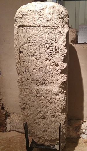
Nero stone tablet from Nahariyah
Courtesy Hecht Museum
-
Ottoman period
The area around the site is part of the Zevulun Valley (Emek Zevulun) and the Acre plain, which was characterized by extensive marshlands, particularly around the Kishon River and the Na’aman River (Mughr el Ghab). The Ottoman map below also shows a large marsh area west of the site. The presence of malaria in the swamps meant that permanent, large-scale settlements in the immediate marsh area were sparse in the early and mid-19th century.
Instead, the primary inhabitants of these specific marsh areas were members of the Bedouin tribe called the ‘Arab al-Ghawarina (or simply Ghawarina), whose name translates to “people of the lower area/valley”. They were semi-nomadic and lived in non-permanent dwellings or tent encampments among the reeds. They engaged in pastoralism (raising water buffaloes, sheep, and cattle) and some cultivation of crops like rice, a lifestyle adapted to the marsh environment.
In Jidru was one of the 5 Bedouin tenant farmer villages that were established during the Ottoman period in the Zevulun valley. These villages were owned by the Sursock family (also spelled Sursuq), a wealthy Greek Orthodox Christian family from Beirut, Lebanon. In the Jidru farmhouse were 60 residents (as counted in year 1870). They lived in a white house on the south west side of the farm, naming it Dar-el-Beida (“The White House”).
A 1926 photo of bedouins, on a farm in the bay of Haifa, may have been the site of Jidru.

Bedouins in the Bay of Haifa, 1926; Matson collection, public domain;
In 1875 Victor Guérin noted (Guerin, 1880, p. 409):
“…I arrive at Bir Djedrou. This village, recently raised from its ruins, is supplied with water by a well which one descends by a few steps, and which is covered by a small square construction surmounted by a dome. The stones that were used for this building seem ancient”.
- PEF Survey
The area was examined in the PEF survey (1866-1877) by Wilson, Conder and Kitchener. A section of their map is seen here, and the site appears as Jidru.
In their report, they described the farmhouse of the bedoins (Volume I, Sheet 5, p. 285): “…little farmhouse of Jidru, with a well. It belongs to a Greek from Constantinople.”. They did not describe the ancient site.
On the map is another site – Tell el Khiar – that they described as (Volume I, Sheet 5, p. 352): “Tell el Khiar —A low mound; fragments of p0ttery and glass”. According to “Ancient site of the Galilee”, by Salomon E. Grootkerk, p. 154, this small mound is 200m south west of Horvat Gedora. However, this mound (south of the gas station) was leveled by the farmers and no trace of it can be seen.
This section of the map there is a line of ancient sites: Jidru (Horvat Gedora), Tell el Khiar, Tell es Subat (Tel Zavat) and Tell en Nahal (Tel Nahal). They were part of the road that turned south-west, crossing the Kishon River, toward the ancient port town at Tell Abu Huwam (east of modern Haifa), and then around Mt. Carmel to continue south. Another route passed the site towards Jokneam. So the split of the road at Gedora to south west and south east continued as in ancient times.
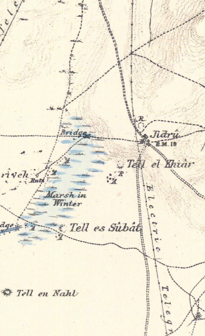
Part of Map sheet 5 of Survey of Western Palestine,
by Conder and Kitchener, 1872-1877.
(Published 1880, reprinted by LifeintheHolyLand.com)
- British Mandate period
* Haifa Bay Development company:
A section of the 1940s British Mandate map shows the area around the site. During the British period the main north-south road, from Akko/Acre to Haifa, was paved along the west side of Kiryat Bialik, 1km west of the site. The area west of the site, once an area of sand dunes and marshes, was now built with modern residential quarters (the “Krayot”). The swamps have been drained in the past century with canals that let the water flow to the Kishon river and out to the Mediterranean sea.
Kfar-Bialik, an agriculture village (Moshav), was built west and south of the ancient site. It is not marked on this map.
The ancient mound appears here as “Kh. Jidru”. A cemetery is marked on the noth west side of the mound. Two other ancient sites appear here – Tell ez Zibda to the north and Tell es Subat (Tel Zavat) to the south. These sites were adjacent to the ancient coastal road.
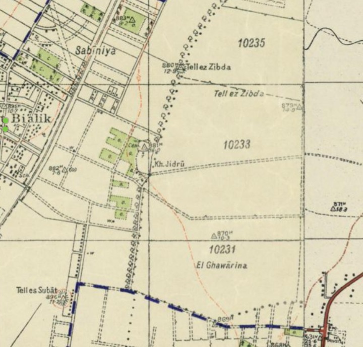
British survey map 1942-1948 – https://palopenmaps.org topo maps
License: public domain under the UK Copyright, Designs and Patent Act 1998
-
Modern Times
In 2007 excavations were conducted on the north- eastern side of the Tell, as part of the preparations for a new highway that is designed to pass on the east and south side of the Tell. A section of Via Maris may have been found in one of the trial square pits.
Photos:
(a) General views:
This is a view towards the north. The concrete water tower, on the center of the top of the mound, was built in 1934. It supplied water to the village and served as a fortified watch tower on the highest point in the area. It was fed from a water pump house that is located on the north west side of the mound.
The historic tower has found new life as a museum, where an original wooden staircase climbs toward its gallery. Every year on national memorial days, the tower stands as a silent witness and backdrop to ceremonies held in honor of the fallen soldiers of Kfar Bialik.
Click on the photo to view it in higher resolution…
According to the Haifa-East survey listing, a square cistern south of the ruin was a partly destroyed vault. Remains of a smaller vault was found on the south eatsern corner.
The top of the hill is covered with small sandstone and limestone rocks, and some pottery sherds. This is a view of the northern section of the mound, with a view towards the south west. Mt. Carmel is seen on the far background.
On the mound’s northwest slope lies a ruined Muslim cemetery, marked by modest rectangular graves surrounded by fieldstones. These were probably graves of the Ghawarina bedouins who resided in the area, and worked in the Jidru farm more than 100 years ago.
Although chemical treatments are used to clear the overgrowth from the site, nature takes over, and the weeds grow back around the stones until the next time the area of the cemetery is treated. In a recent visit (Feb 2026) the area was clean again of the weeds.
(b) Pottery
Across the site, and spread on the fields around the mound, are sherds of a wide range of periods: Iron Age, Persian, Hellenistic, Early Roman, Late Roman, Byzantine, Muslim, Crusaders and Mameluke periods (Yalkut 4786).
(c) Rhodian Amphora
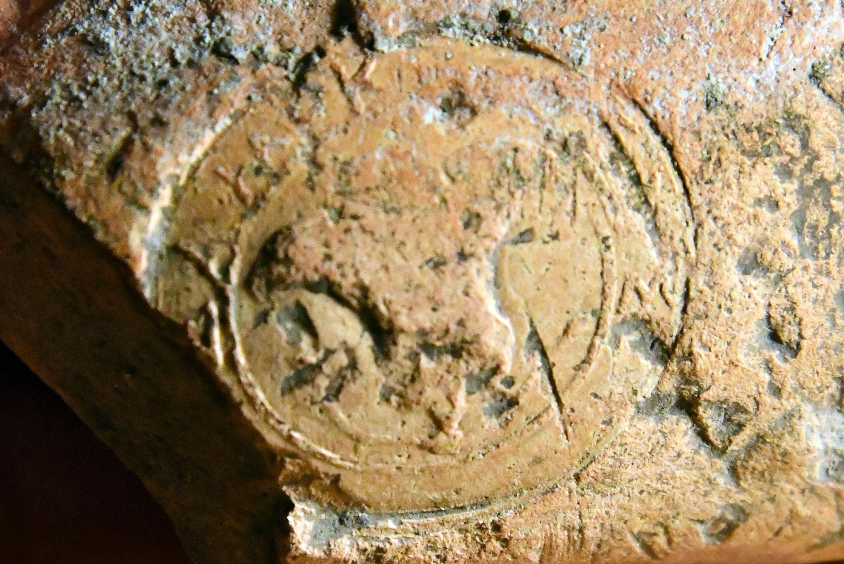
We also found a wonderful piece of archaeological evidence – a stamped amphora handle, which acts like an “ancient corporate logo” or a “vintage seal.” . It is 8cm in length.
The stamp belongs to a potter (or fabricant) named Damokrates (ΔΑΜΟΚΡΑΤΗΣ). He was one of the most prolific and famous amphora producers on the island of Rhodes during the late 3rd and early 2nd centuries BC. Rhodian stamps were unique because they often featured the Rose of Rhodes. In Greek, the word for rose is rhodon (ῥόδον), making it a visual pun on the name of the island.
The stamp wasn’t just for decoration. Rhodian amphorae were the “gold standard” of wine transport. The stamps served three main purposes:
- Quality Control: Verifying the capacity of the jar (usually about 25–28 liters).
- Taxation: Tracking exports for the Rhodian authorities.
- Dating: Many handles also included the name of the Eponym (the priest of Helios who served that year), which allows modern archaeologists to date these finds with incredible precision—often to within a single year.
Example of such stamped handle can be seen in the Met museum. This handle from Gedora was delivered to the IAA.
Below is a closer view of the stamp. The letters ΔΑΜΟΚP—Σ (Damokr—s) clearly stand up clockwise around the sign of the rose.
-
Sophisticated Residents: The people living on the mound at that time weren’t just subsistence farmers; they had the wealth and the taste to import “premium” Greek wine.
-
Trade Hub: It confirms Tel Gedora’s role as a stop along the trade routes branching out from the major port of Acre (Ptolemais). Wine would arrive at the port and be distributed to smaller inland settlements like this one.
-
The Hellenistic Influence: This period (the transition between Ptolemaic and Seleucid Greek rule) was a time of intense “globalization” in the Levant, where Greek goods and customs became common even in smaller villages.
- The presence of high-quality, stamped Rhodian wine jars strongly suggests a population that was part of the Greek-speaking, pagan world of the coast.At that time, the Zevulun Valley and the coastal plain were largely under the influence of the Phoenician city of Acre (Ptolemais). The residents of Tel Gedora were likely Hellenized Phoenicians or Greeks who had no religious restrictions against Rhodian imports.
- The residents on Gedora were probably non-Jewish. During this era, particularly leading up to the Maccabean Revolt (167 BC), there was an increasing push to avoid Greek wine because it was often dedicated to Greek gods (like Dionysus or Helios, the sun god of Rhodes) during production. Jewish dietary laws (Kashrut) have a specific prohibition regarding “Yayin Nesech” (wine used for libations) or “Stam Yenam” (wine produced by non-Jews).
Rhodian wine was sometimes considered a bit “cheap” or “medicinal” by ancient connoisseurs because it was often flavored with seawater or pine resin to preserve it during travel. However, the jars themselves were so well-made that they were frequently reused for years as water containers after the wine was gone!
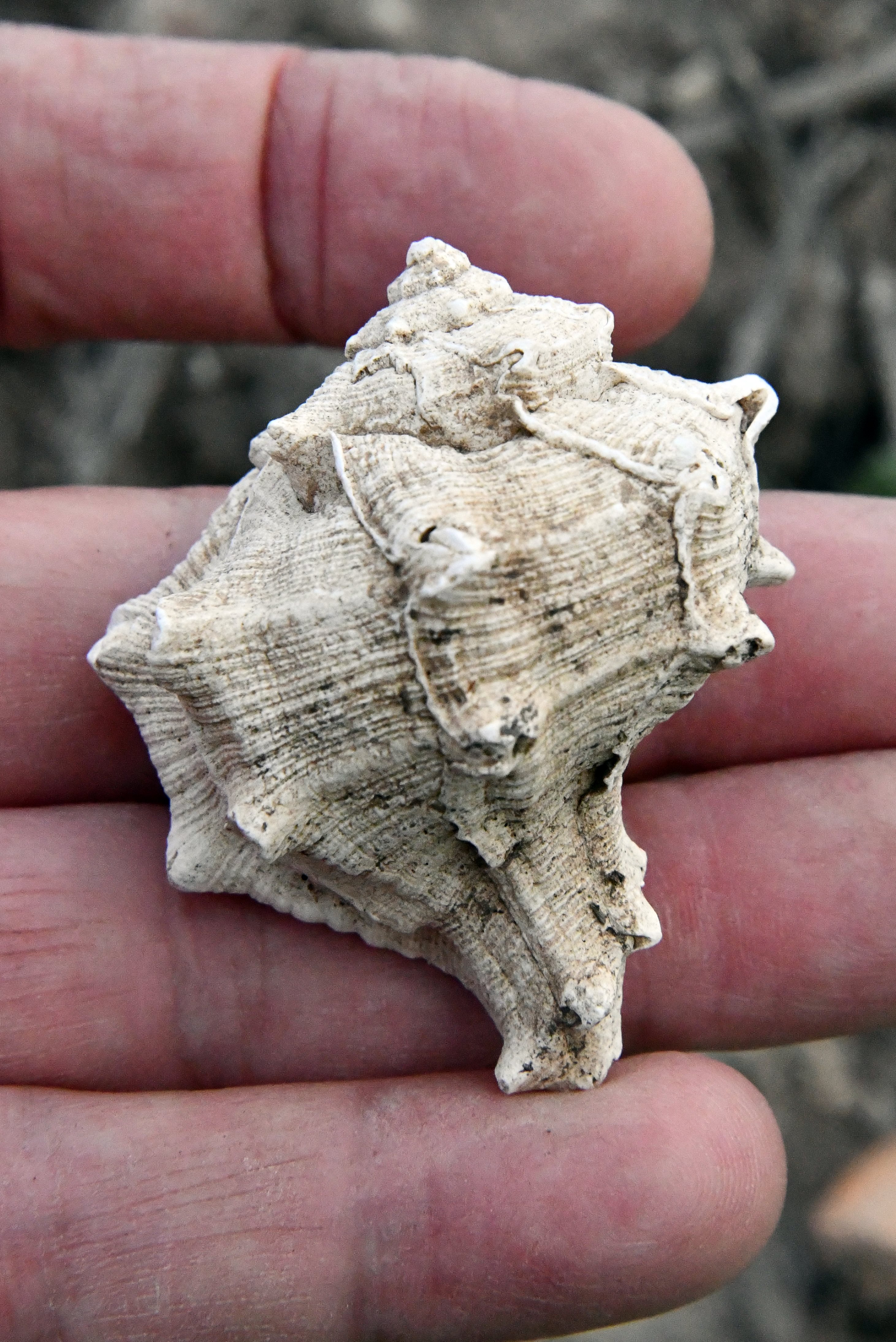
(d) Purple Dye Snails
Dozens of these shells can be found in the fields around the site.
This medium-sized marine snail (Hilazon in Hebrew, Murex trunculus as scientific name) was one of the important sources of dye colors in antiquity. The Canaanites, Hebrews of the Zebulun tribe, and especially the Phoenicians produced the deep-purple indigo dye which was used for the textile industry.
The Old testament specifies a blue dye (Tekhelet) for use in the Priestly garments as well in the layman’s tzizit (fringes). For example (Exodus 28:6): “And they shall make the ephod of gold, of blue, and of purple, of scarlet, and fine twined linen, with cunning work”.
According to Greek legend, the purple dye was discovered by chance: the patron gods of Tyre, Melqart and Tyros, were walking along the shore with their dog. The dog bit a snail, and came to his master with his mouth stained with color. Melqart collected more shells and prepared a purple robe for Tyros. Later, the Phoenicians of Tyre and around the Mediterranean coast skilled in purple dyeing. The Greek name of “Phoenician” means red-purple, based on their production and trade of the purple cloths.
Since 60,000 murex were needed to produce one pound of dye, the dye was highly prized in ancient times. Their shells are found in most of the Phoenician sites along the coast in Israel and Lebanon.
Judging from the number of shells found around the site, there could have been a purple dye industry workshop near the site.
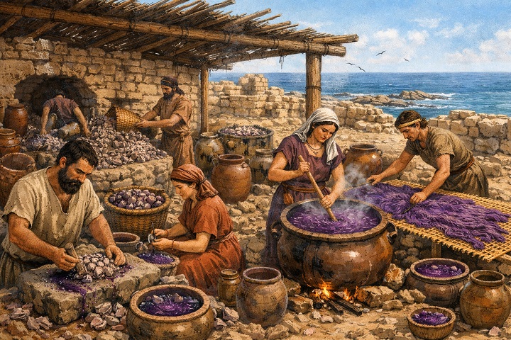
Illustration of purple dye workshop near Tel Shikmona (Image created by AI using OpenAI’s ChatGPT)
(e) Nature
A wild flower, found in the fields around the site, is common in agriculture farms – barns, cowsheds and poultry enclosures. This flower is called Solenum (Silverleaf Nightshade, or: Solanum elaeagnifolium), which flowers between May-August.
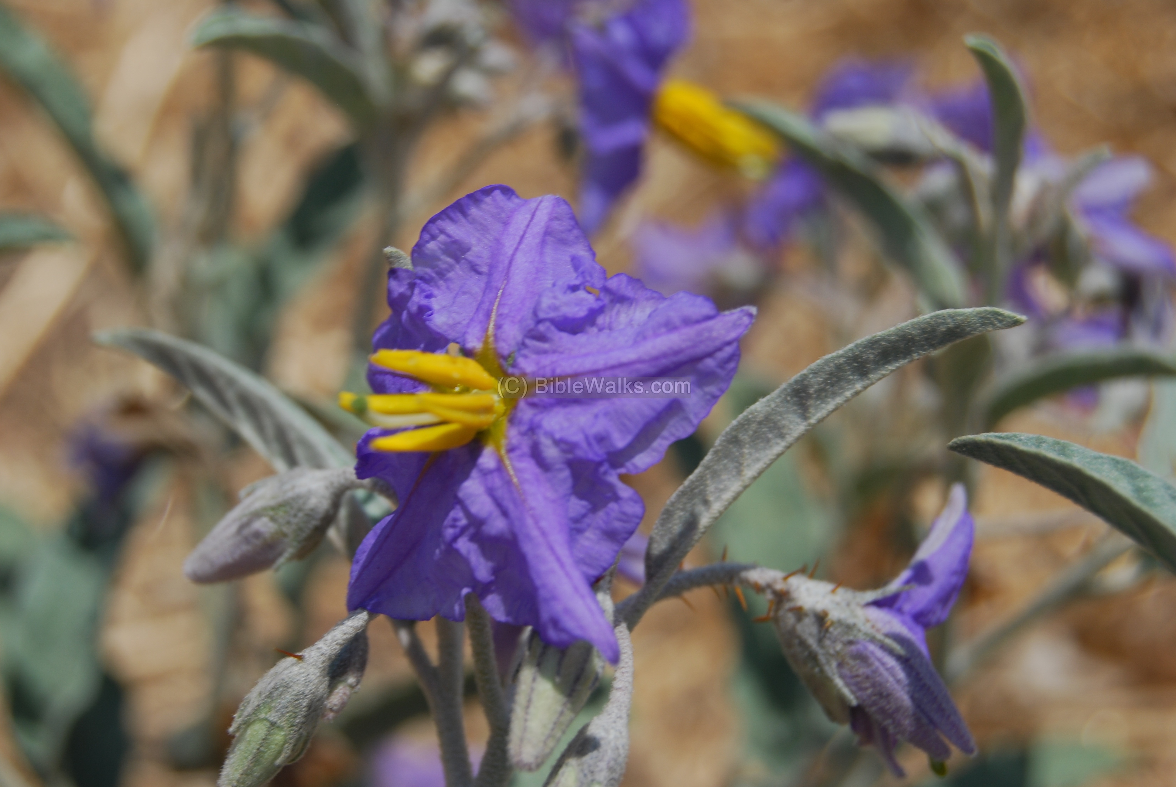
Its fruits small, round berries that start green, turning yellow/orange as they ripen. They are eaten by bats and birds, who spread it through their droppings. Warning: the fruits and other parts of this plant are poisonous if eaten by humans, and may even cause death!
(f) Sculpture
A small industrial area and a local gass station are located around the site. One of the workshops added a metal sculpture of a person holding the national flag. It can be seen from the adjacent highway 22 that passes nearby.
Etymology (behind the name):
-
Tel, Tell – a layered mound (read about the story of the Tells, including our animation)
-
Gedora – Hebrew name of the site. The name Gedora (גְּדוֹרָה) is derived from the Hebrew word Geder (גדר), meaning “fence,” “wall,” or “enclosure.” In an archaeological context, it usually refers to a “sheepfold” or a fortified enclosure.
- Gedro – name of the site on Roman period milestone.
- Jidru – Arabic name of the site. The PEF dictionary suggested it was a private name. It preserves the ancient Semitic root for “wall” or “enclosure.”, and the name Gedro that was used during the Roman period.
- Tell el Khiar – Arabic: the mound of the cucumbers.
-
Derech Hayam – Hebrew – the way of the sea. In Latin; Via Maris. Biblical reference (Isaiah 9,1): “Nevertheless the dimness shall not be such as was in her vexation, when at the first he lightly afflicted the land of Zebulun and the land of Naphtali, and afterward did more grievously afflict her by the way of the sea, beyond Jordan, in Galilee of the nations”.
References:
- David Dorsey (“The roads and Highways of Ancient Israel”, 2018) – pp. 78-81
Links:
- Bedouin Settlement in Late Ottoman and British Mandatory Palestine: Influence on the Cultural and Environmental Landscape, 1870-194; January 2011, S. Frantzman, R. Kark
- Zevulun survey – Deshe
- Yalkut 4786 – overview of the site (Hebrew)
-
Roman Roads – in BibleWalks
BibleWalks.com – touring the sites of the Holy Land
Tell Zavat<<<–previous West Galilee site—<<<All Sites>>>—->>> Kishon River
This page was last updated on Feb 3, 2026 (new page)
Sponsored links: