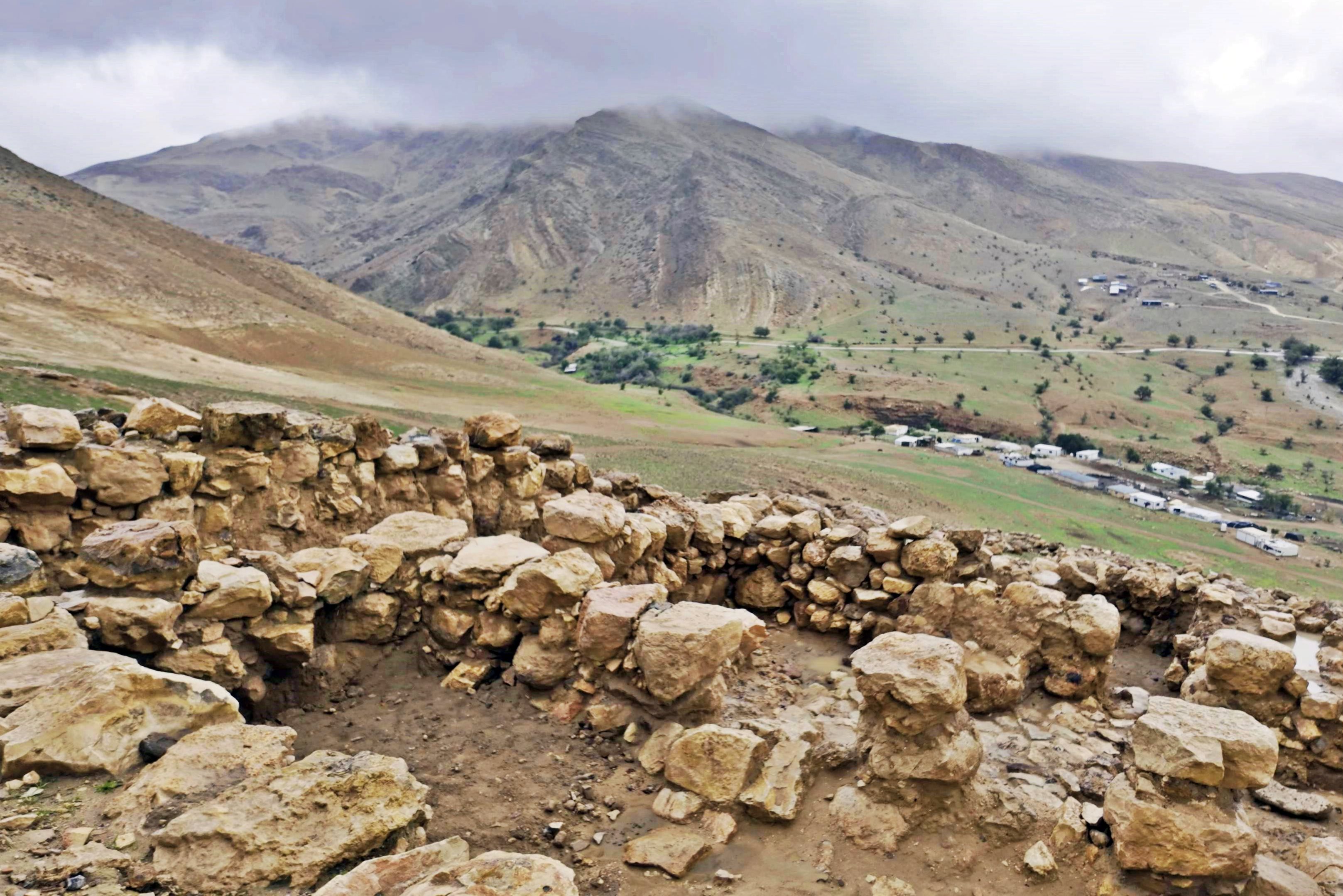
Ruins of a large fortified Iron Age city south of ‘Aujah Valley (Nahal Yitav).
Home > Sites > Jordan Valley>Khirbet ‘Aujah el Foqa
Contents:
Overview
Aerial Map
History
Photos
* Aerial Views
* Ground Views
Videos
Links
Etymology
Background:
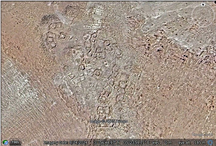
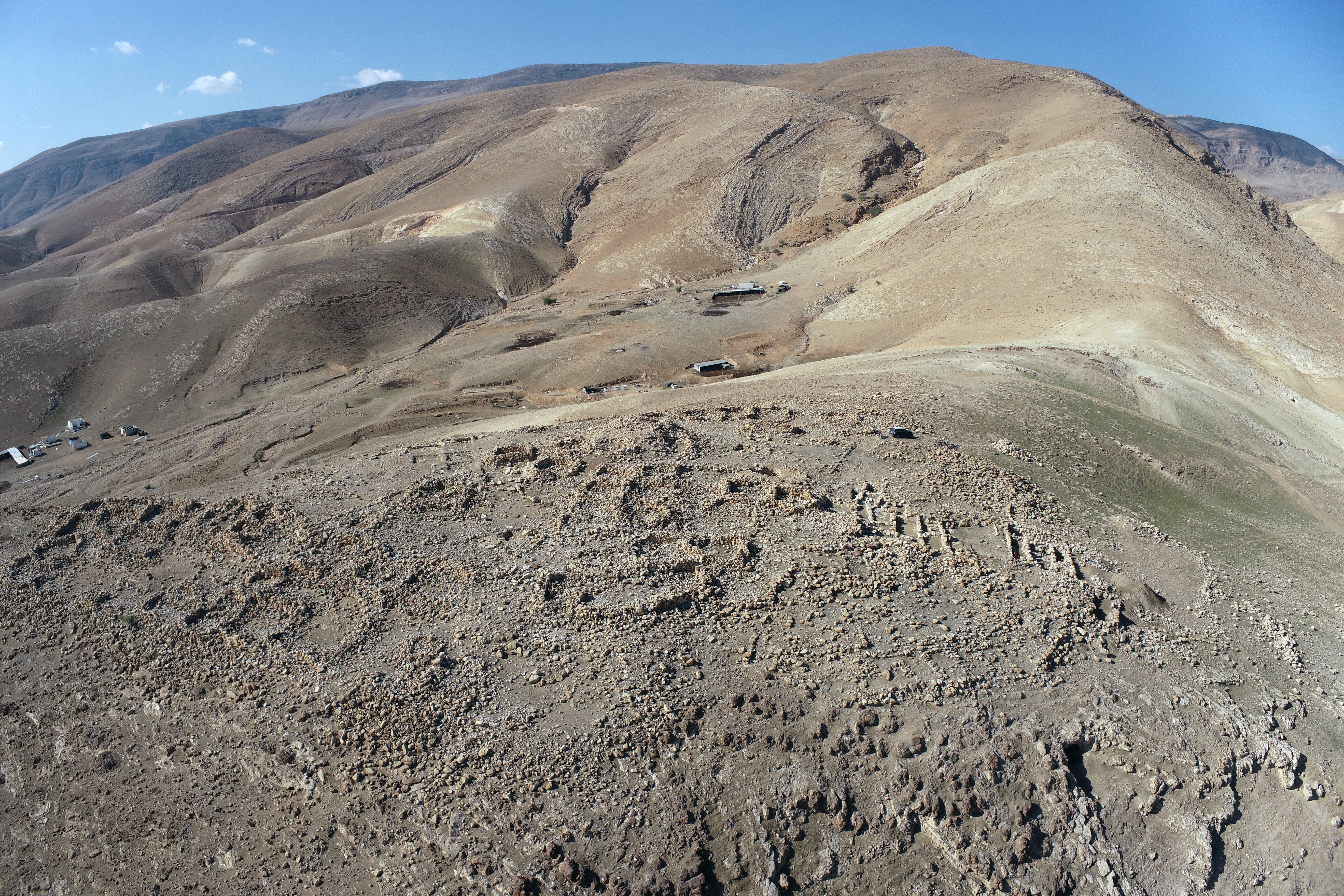
Situated on a prominent limestone spur in the southern Jordan Valley, Khirbet ‘Aujah el-Foqa represents one of the most significant and structurally intact archaeological sites in the region. Located approximately eleven kilometers northwest of Jericho, the site encompasses fifteen dunams across the summit of a steep hill, commanding a strategic position over the southern bank of Wadi Foqa, or Nahal Yitav. The surface is characterized by the conspicuous remains of dozens of stone structures.
The site’s principal occupation occurred during the Iron Age II, a period of significant geopolitical development in the Levant. A defining architectural feature of this era is the site’s casemate wall—a sophisticated double-wall fortification system consisting of two parallel masonry walls joined by transverse walls, creating internal chambers used for storage or living quarters. Based on its geographical coordinates and the biblical record in Joshua 16, researchers have proposed identifying these ruins with the ancient settlements of Ataroth or Na’arah, which served as topographical markers for the border between the tribal territories of Manasseh and Ephraim.
Functionally, the settlement operated as a primary military and administrative hub on the eastern frontier of the Northern and Southern Kingdoms of Israel. Its elevation allowed for absolute visual command over the ‘Aujah Spring—the region’s most vital hydrological resource—and facilitated the monitoring of the critical transit corridors through the Jordan Rift Valley.
Map / Aerial View:
The aerial map shows the area around the ruins. It is located on a ridge that rises 75m above the valley of Wadi ‘Aujah, and 400m away from the stream. The site is 2km west of modern settlement of Moshav Yitav, 10km north west of ancient Tel Jericho, and 12km west of the Jorday river .
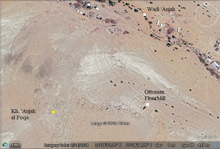
A closer view of the ruins is below. The area of the ruin has an oval shape, with an extension on its south side. The length of the site is 110m north to south, and its width is 85 meters in average west to east.
History:
-
Chalcolithic and Bronze age
According to pottery dating, the site was first inhabited in the Chalcolithic, Early Bronze period and Middle Bronze II periods. These early periods constitued just 5% of the sherds that were collected on the survey. The site was then deserted until the Iron age.
-
Iron (Biblical) Age
A fortified Israelite city was established in the Iron Age I and expanded in the Iron IIB period. Located on a steep, high, and isolated hill, it served as a desert frontier fortress, guarding the eastern border of the kingdom and overseeing the lush spring of ‘En el-Auja. The most significant remains date to the Iron Age II (roughly 9th–8th centuries BC), the era of the biblical Israelite and Judahite monarchies.
The city covered an area of 15 dunams (3.75-acre). The fortified town was protected by a casemate wall (a double wall with rooms inside) and a central tower.
Excavators found complete pottery vessels (storage jars, cooking pots), iron tools, and a rare collection of biconical clay slingstones, which were likely used for defense. A majority (88%) of the sherds found at the site date back to the Iron Age (as per the MHCS survey).
- Biblical Identification
Some scholars, most notably the late Adam Zertal, identify it as biblical Ataroth (Joshua 16:5,7):
“And the border of the children of Ephraim according to their families was thus…And it went down from Janohah to Ataroth, and to Naarath, and came to Jericho, and went out at Jordan”.
Other scholars have suggested it might be the Biblical Na’arah (also listed here as a city near Jericho).
Ataroth vs. Na’arah: Archaeologists are currently debating which Biblical city this site represents. Both names appear in Joshua 16:5–7 as markers of the boundary between the tribes of Ephraim and Manasseh.
-
Theory A: Ataroth. The late archaeologist Adam Zertal proposed this identity. The name Ataroth means “crowns” or “garlands,” which fits the site’s dramatic position “crowning” the top of a steep, isolated hill. However, some suggest that Ataroth is located in Fazael.
-
Theory B: Na’arah. The current excavation directors, David Ben-Shlomo and Ralph K. Hawkins, suggest the site is actually Na’arah (or Na’arta). They argue its location—descending from the highlands toward Jericho—aligns better with the biblical description of the border “going down” from Janoah to Na’arah and touching Jericho.
The cities and roads during the ancient periods, up to the Roman period, are indicated on the Biblical Map below. The site is marked as a red circle.
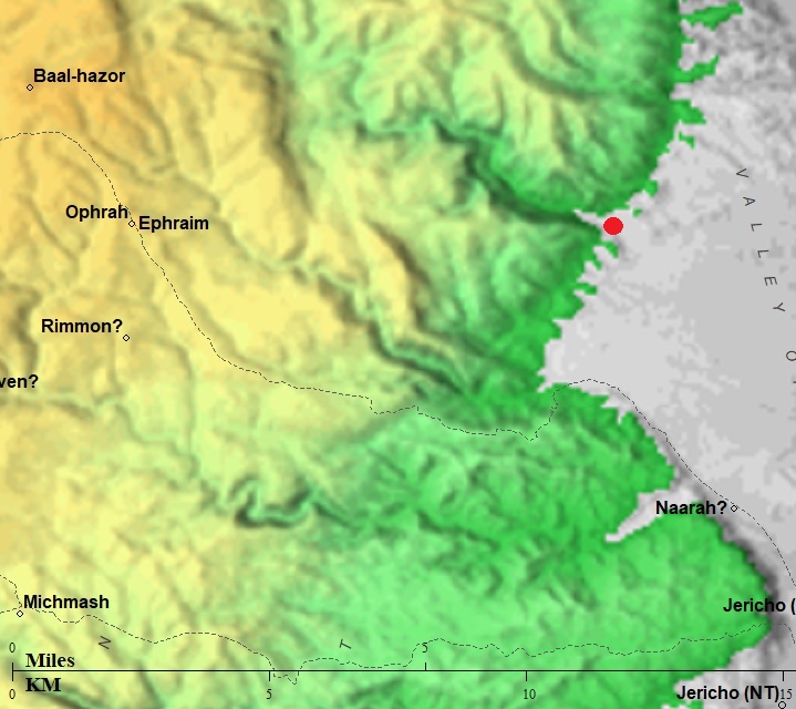
Map of the area – during the Israelite to Roman periods (based on Bible Mapper 3.0)
The strategic placement of the site is emphasized by its relation to a known ancient routes that once traversed this landscape. According to David Dorsey (“The Roads and Highways of Ancient Israel,” 1991, p. 202), this path—designated as Route ‘T29a’—descended from Samaria and reached the Jordan valley at ‘Auja el Tachta (the lower ‘Aujah, Site #409 on Dorsey’s list) passing near the site. This route descended eastward along the course of the ‘Aujah valley to cross the Jordan valley at the ford of Makhdat Mindisa. This river crossing was an important route during the Bronze and Iron Ages.
- Assyrian intrusions and destruction (732-712 BC)
In 732 BC was an intrusion to the North of Israel by the Assyrian King Tiglath-Pileser III, who annexed the area (as per 2 Kings 15: 29): “In the days of Pekah king of Israel came Tiglathpileser king of Assyria, and took … Galilee…and carried them captive to Assyria”. This intrusion affected the north of the Kingdom.
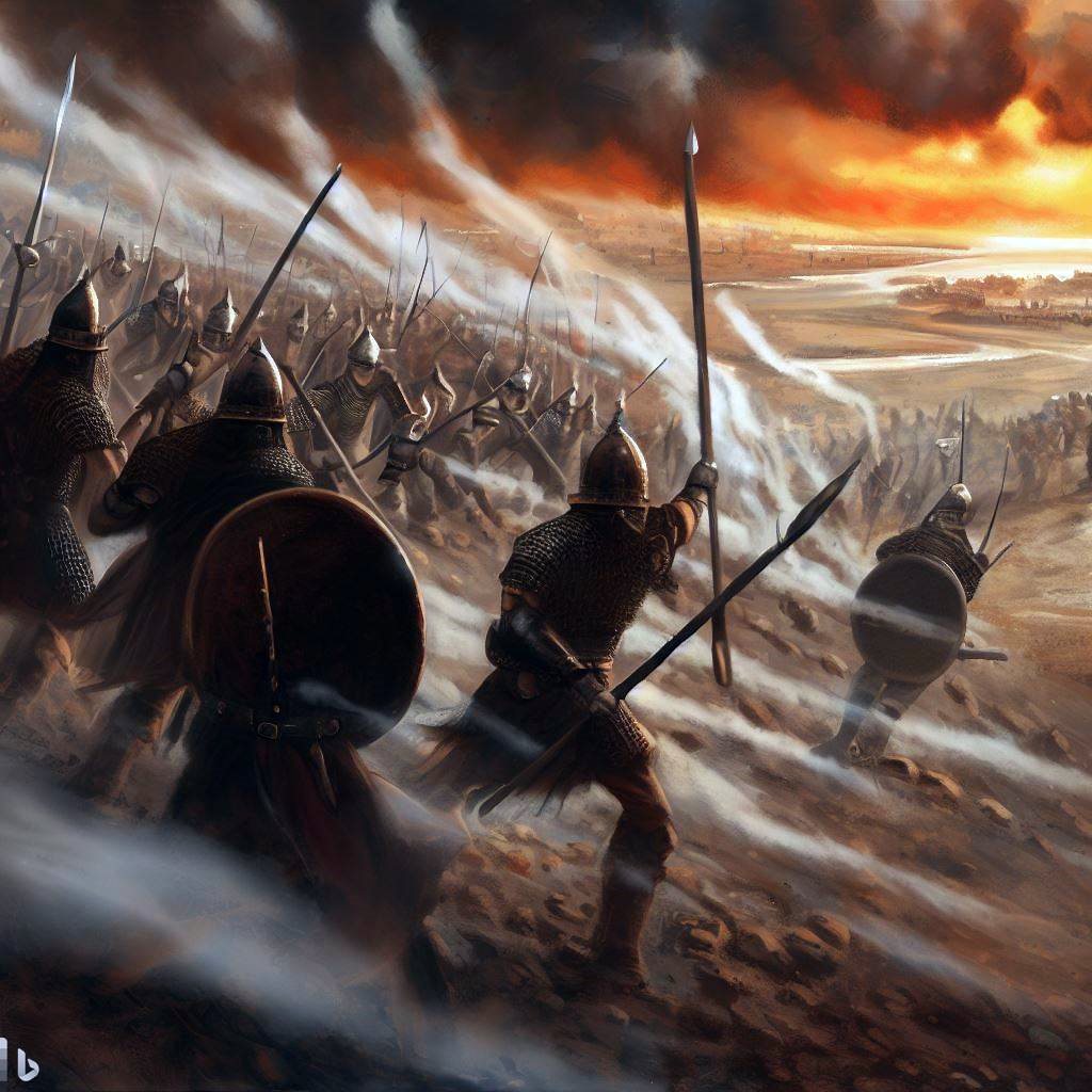
Assyrian forces attacking – AI generated by Bing
Following the death of Tiglath-Pileser, the Egyptians encouraged the people in the occupied territories of the Assyrians to revolt. Hoshea, King of Northern Israel, joined this mutiny, but made a fatal mistake. This time the Assyrians crushed the remaining territories of the Northern Kingdom. The intrusions of Shalmaneser V and Sargon II in 724-712 ended the Northern Kingdom (2 Kings 17: 5-6):
“Then the king of Assyria came up throughout all the land, and went up to Samaria, and besieged it three years. In the ninth year of Hoshea the king of Assyria took Samaria, and carried Israel away into Assyria, and placed them in Halah and in Habor by the river of Gozan, and in the cities of the Medes”.
The villages in the Galilee and Samaria were destroyed or abandoned. Evidence of a violent destruction (or hasty abandonment) was found here to occur during the 8th century BC, potentially linked to the Assyrian campaigns (e.g., Sargon II’s campaign in 720 BC).
-
Early Roman period
During the time of King Herod, the Jordan valley witnessed an unprecedented growth, which included construction of new roads, villages and water supply systems. The Fazael valley, north of the site, was one of the areas that benefitted from this growth. Herod established the nearby desert town of Fazael (Phasaelis) on his estate, and named it after his brother.
The settlement on this site was scarce during this period.
A major Roman road used the valley of Wadi el Abeid, 3km south of the site, to ascend from Jericho to the heart of Samaria. Modern highway #449 (aka, “Tarik abu George”) also uses this path. It is marked on the map above as a dashed line.
The aqueducts originating from ‘Ain ‘Aujah (also known as ‘Ein el-‘Aujah) are part of one of the most sophisticated ancient water management systems in the Jordan Valley. Because ‘Ain ‘Aujah is the most abundant spring in the region, it was utilized by several Judean dynasties to transform the arid valley into a lush agricultural estate. The system primarily consists of two major historical branches:
1. The Hasmonean & Herodian Aqueduct (The Main Branch):
This is the most famous system, constructed to transport water over long distances to support royal palaces and agriculture. It carried water approximately 12–15 km south to the Winter Palaces at Jericho (Tulul Abu el-‘Alayiq) and the agricultural estates on the banks of Wadi Qelt. Originally built under the Hasmonean kings (likely John Hyrcanus or Alexander Jannaeus) in the 2nd–1st centuries BC. King Herod the Great later renovated and integrated this system into his own massive building projects. He used the water to irrigate his famous balsam and date palm groves, which were highly lucrative export crops. The aqueduct was a masterpiece of gravity-fed engineering, maintaining a very slight but consistent slope over rugged terrain. It included rock-cut channels, plastered masonry, and bridges to cross desert wadis.
2. The Aqueduct to Archelais
A shorter branch of the ‘Ain ‘Aujah system was dedicated to the town of Archelais (modern Khirbet el-Beiyudat). This town and its accompanying aqueduct were built by Herod Archelaus, the son of Herod the Great. Archelaus founded the village specifically to house workers for his new date palm plantations, and the aqueduct provided the necessary irrigation to turn the surrounding desert into a productive oasis.
-
Byzantine period
During the late Roman and Byzantine period, there was some presence on the site. Sherds from the Roman/Byzantine, Middle Ages, and Ottoman periods constituted just 7% of the total pottery collected in the MHCS survey.
Aqueducts were constructed during this period to convey the spring’s waters, passing to the north of the hill (Site #141 in MHCS Volume 5). Additional aqueducts were built along the south and east sides of the hill.
- Mamluke and Ottoman periods
During the middle ages several dozen rounded stone houses built over the ancient ruins and using stones “robbed” from the original Iron Age walls. These are the most visible remains on the hill today.
The area was examined in the PEF survey (1866-1877) by Wilson, Conder and Kitchener. A section of their map is seen here. The site is indicated on the map as Khirbet ‘Aujah el Foka (“Upper ‘Aujah”). Their report of the site was merely a short sentance, and they assumed that the standing walls probably are modern (Volume 2, p. 391): “Khürbet el ‘Aujeh el Foka (Or).—A ruined village on a mound, the ruins apparently modern”. The surveyors did not further research the ancient mound under the ruins.
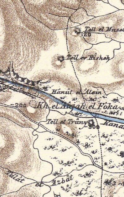
Part of Map sheet 15 of Survey of Western Palestine, by Conder and Kitchener, 1872-1877.
(Published 1880, reprinted by LifeintheHolyLand.com)
The PEF surveyors described the spring of ‘Ain el Aujeh, 1.5km north west of the site (Volume II, p.383): “This valley, called Widy el Mellahah is joined by the ‘Aujeh valley, which has a supply of fresh water from the fine spring (‘Ain el ‘Aujeh) at its head. An aqueduct from the spring formerly irrigated the Ghor”. They added (p. 263): “The water of the ‘Aujeh is very turbid, carrying down much sand”.
The waters from ‘Ain ‘Aujah remained vital long after the Roman period. During the Umayyad Period (7th and 8th centuries AD), the aqueducts were repaired and used to supply water to Hisham’s Palace (Khirbet al-Mafjar) and its surrounding farms. In the late 19th and early 20th centuries, several stone flour mills were built along the path of the spring’s flow, utilizing the drop in elevation to turn millstones.
- British Mandate
A section of the 1940s British map shows the area around the site. The map shows a “Disused Roman Canal” that passes along the eastern side of the site. Along the valley on the north east side is a road that leads upstream to the spring (‘Ain el ‘Aujah). On all sides of the site are roads that lead to the north and to the west.
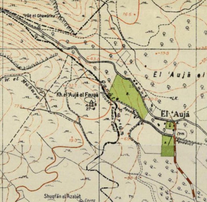
British survey map 1942-1948 – https://palopenmaps.org topo maps
License: public domain under the UK Copyright, Designs and Patent Act 1998
-
Modern times
The Jordan valley underwent a total reconstruction after the six day war (1967) under Israeli control. A new agricultural settlement, Moshav Yitav (Hebrew: יִיטַ”ב, an abbreviation of Yad Yitzhak Tabenkin), was established in 1970, 2km east of the ancient site. It started as a Nahal settlement, and was recognised by the state in 1977 as a kibbutz. It was abandoned in 1982, re-established in 1993 as a agriculture Moshav.
Recent excavations at Khirbet ‘Aujah el-Foqa (2019–2024) have significantly expanded our understanding of this site, transforming it from a “mysterious ruin” into a major focal point for studying the ancient Kingdom of Israel’s eastern frontier. In our surveys of the Jordan valley we have identified similar Iron Age II fortified sites, built along roads that ascended from the Jordan valley to the western highlands, but this site is indeed impressive.
Photos:
(a) Aerial views:
An aerial view of the site is seen here, with a view towards the Samarian hills on the south west.
The ruins cover an area of 15 dunams. The length of the site is 110m north to south, and its width is 85 meters in average west to east.
Click on the photos to view in higher resolution…
Aerial view by A. Keidar, Dec 2025
A closer view of a section on the north side of the ruins is below. Some of the structures were excavated, while others await future research.
Notice the casemate wall on the left side, and on the bottom of this view is a four-room house typical of the Iron Age.
Aerial view by A. Keidar, Dec 2025
(b) General views:
- Structures
Within the site’s perimeter, dozens of architectural features remain visible, revealing an urban plan that has remained remarkably consistent since the Iron Age. The city’s original layout exhibits minimal alteration, with very few subsequent extensions identified. The state of preservation is significant: several fortification and domestic walls still reach heights of 1 to 1.5 meters. Most notably, a central tower situated in the northwestern sector of the walled city survives to an impressive height of 5 meters.
While many of the extant remains date back to the primary Iron Age occupation, other structures reflect secondary use during later historical periods. These later additions largely utilized the original Iron Age foundations and adhered to the site’s established spatial organization.
- “Four Room” house
The Four-Room House (also known as the “Israelite House”) is the most iconic architectural feature of the Iron Age in the Levant. It appeared around the 12th century BC and remained the dominant domestic design until the Babylonian destruction in the 6th century BC.
Below – A view from the 4-room house to the ‘Aujah valley on the north and east. Note that the bars on the meter scale stick are 10cm (3.9″) wide.
Its design was so standardized that archaeologists use it as a primary indicator of sedentary life and social organization during the monarchic period.
1. The Layout and Architecture – Despite the name, a “four-room house” did not always have exactly four rooms; rather, it followed a specific tripartite+one spatial logic:
- The Central Courtyard (The “Long” Rooms): The house was divided into three parallel longitudinal areas. The central area was usually an open-air courtyard where cooking, weaving, and animal maintenance took place.
- The Side Aisles: Flanking the courtyard were two side rooms, often separated by a row of stone pillars. These pillars supported a roof or a second story.
- The Broad Room: A single room ran the entire width of the house at the back. This was typically the most “private” area, used for sleeping or secure storage of valuables.
Functional Sophistication:
The four-room house was a masterpiece of multi-functional living:
- Animal Integration: The side aisles often had stone mangers between the pillars. Livestock (goats or sheep) were kept inside at night to provide warmth to the family and protection for the animals.
- Vertical Living: Most scholars agree these houses had a second story or at least a flat, functional roof. The ground floor was for industry and animals, while the upper floor served as the primary living and sleeping quarters for the family.
- Storage: Large ceramic pithoi (storage jars) for grain, oil, and wine were typically found in the back broad room or sunk into the floors of the side rooms.
Below, the middle room within the “four room” house – a paved floor, with an oven and a griding stone.
- North Eastern Casemate wall
In the architecture of the Iron Age Levant, the casemate wall was a clever and cost-effective engineering solution used to fortify cities. Instead of building a single, massive solid wall (which required enormous amounts of stone and labor), engineers constructed two thinner, parallel walls and joined them with short transverse walls.
The north-eastern casemate wall (marked as “CW2” in the MHCS5 map on page 497) is 45m long. It is built of 2 parallel walls, each 1m in width. The walls are separated by 4m-5m. Cross-walls (transverse) walls are built every 4-5m, separating a dozen or more chambers along the length of the casemate wall. These cross-walls acted as “ribs,” bracing the two main walls against each other and providing structural integrity. The rooms created between the walls, known as casemates, were 4-5 meters long and 4-5m meters wide. During times of peace, the casemate rooms were used for grain storage, workshops, or even as living quarters for soldiers and their families.
Another parallel wall was laid on the west side of the casemate wall, with croos-walls that created additional rooms.
In one of the casemate rooms we encountered an illicit digging area, with large pottery sherds.
These sherds, left by the digger, were all dated to the Iron Age II.
- South Eastern Casemate wall
Another casemate wall on the south east side of the city (marked as “CW4” in the MHCS5 map on page 497) is 40m long, and reaches the southern edge of the city. A set of 4 rooms connect the edge to the western casemate wall (“CW1”).
- Western casemate
A longer casemate wall on the west side of the city (marked as “CW1” in the MHCS5 map on page 497) is 90m long, and connects the southern edge of the city to the north western area near the central tower (seen here on the right side).
This western casemate wall is 5m wide in average. The external wall (here on the right side) and the internal wall (here on the left side) are built of 2 coupled rows of field stones, with a width of 1m each.
The total 21 casemate chambers are 5m square. In the photo below are 3 such rooms. each separated by a 0.5m wide thin wall (one course of field stones).
Entrances, such as seen here, allow passege to the chamber from the inside area. Along the wall, from the side, are several rooms that are built against the casemate wall.
- Central tower
The central tower (marked “1” on the map) rises in the north western area of the city. It rises 5m above the area, allowing a view of the area around the city.
The tower, 7.5m by 7.5m, was built on the north west corner of a square courtyard (an area of 15m by 15m). The walls of the tower are plastered from the inside, and its entrance is from the west side.
- Roman/Byzantine period
Archaeological evidence further indicates subsequent phases of limited occupation during the Roman/Byzantine and Ottoman periods. During these eras, the primary Iron Age structures were salvaged and reused for secondary purposes, as evidenced by the presence of diagnostic ceramic sherds.
Notable among the architectural remains is a finely dressed limestone pillar featuring a recessed cavity at its apex; based on its craftsmanship and morphology, this feature is tentatively dated to the Roman/Byzantine period.
Videos:
(a) Survey (Full view, 29 minutes):
BibleWalks team surveys thius exciting site.
(b) Survey overview (1 minute):
A short overview of the site.
Links:
* External links:
- “The Manasseh hill country survey”, Volume 5 – Middle Jordan Valley [Adam Zertal , Hebrew, 2012] – Site #143 pp. 390-393; Appendix 3 pp. 494-534
- Excavations at Khirbet ‘Aujah el-Foqa: Results from the 2020–2021 Seasons – David Ben-Shlomo, Michael Freikman, and Ralph K. Hawkins
- Excavations at Khirbet ‘Aujah el-Foqa: Results from the 2022–2023 Seasons – David Ben-Shlomo, Michael Freikman, and Ralph K. Hawkins
- “With a Sling and with a Stone”: Iron Age Slingstones and Possible Slingstones from Khirbet ‘Aujah el-Foqa –
David Ben-Shlomo and Michael Freikman - New Excavations at Khirbet Aujah el-Foqa and the Iron Age II Settlement – David Ben-Shlomo, Michael Freikman and Ralph K. Hawkins, 2020
- Kh. ‘Aujah el-Foqa (Ataroth) — An Iron age fortified city in the Jordan valley – Adam Zertal, Dror Ben-Yosef, Oren Cohen and Ron Be’eri, 2009
* Internal links:
- ‘Auja el Foqa Field Survey – BibleWalks; YouTube, Jan 2, 2026
- ‘Auja el Foqa Aerial views – BibleWalks; YouTube, Jan 2, 2026
- Jordan Valley Archaeological survey – BibleWalks research
Etymology – behind the name:
- Wadi – Arabic: valley
- Wadi ‘Aujah – The valley of ‘Aujah, a riverbed known for its winding or “crooked” path.
- ‘Aujah, ‘Auja – Arabic for “crooked” or “bent.”
- Nahal Yitav – the Hebrew name of the valley
- El-Foqa: Means “Upper” or “Higher.” This distinguishes it from ‘Auja et-Tahta (“Lower ‘Auja”), which is the lower portion of the valley or the modern Palestinian village of Al-Auja.
- Yitav – name of the modern settlement; Hebrew: יִיטַ”ב, an abbreviation of Yad Yitzhak Tabenkin also means “will be btter”
BibleWalks.com – walks along the Jordan river
Jordan-Jericho <<<—previous site—<<<All Sites>>>—next Jordan Valley site—> >>Fazael Brook
This page was last updated on Jan 5, 2026 (add photos)
Sponsored Links: