Tel Yin’am is a multi-period ruin, strategically positioned in the Yavne’el Valley. It is identified as Biblical Jabneel, a southern border town of the Naphtali tribe.
Home > Sites > Lower Galilee> Tel Yin’am (Yenoam, Yavne’el, Jabneel)
Contents:
Overview
Aerial Map
History
Photos
Videos
Etymology
Links
Background:
Tel Yin’am is a multi-period ruin, strategically positioned in the Yavne’el Valley. It is identified as Biblical Jabneel, a southern border town of the Naphtali tribe (Joshua 19:32, 33). “The sixth lot came out to the children of Naphtali… and Adami, Nekeb, and Jabneel, unto Lakum; and the outgoings thereof were at Jordan”.
Map / Aerial View:
The aerial map below shows the area around the site, indicating the main points of interest. The mound rises 12m above the area. It is now 85m in diameter, but the ancient city once extended beyond the mound. There are ancient remains on terraces that rise 5m above the area, extending 100m to the north and west of the mound, and 50m to the south.

History:
The site shows continuous occupation from the Neolithic period through the Roman era, indicating it was a long-standing settlement.
- Neolithic and Chalcolithic
The site was settled starting from the early periods. Stone tools and pottery fragments of these periods were found in the mound as fills and in the terraces around the mound.
- Early to Middle Bronze
Around the mound the excavators unearthed remains of the Early Bronze 1 period.
Settlement during the Middle Bronze IIb was also limited.
- Late Bronze II period (14th-13th century BC)
During the Late Bronze age II (1300-1200 BC), a large Canaanite settlement was built on a natural hill, servicing an important route along the Yavne’el (Jabneel) valley. A nearby spring provided the settlement with fresh water supply, and farming fields around it provided food supplies.
The excavators unearthed a central building that was probably the residence of the governor. Within the central building the archaeologists mapped 8 rooms so far: four storage rooms on the west side, two smaller storage rooms to the east of them, and two rooms on the east side. In Rooms 2-4, 6 and 8 the excavations unearthed fragments of various ceramic and basalt vessels. Room 5 contained ceramic vessels, engraved cylinder seals and stamp seals with animal figure, onyx pendant, and beads of ceramic, faience and glass. In Room 7 the archaeologists found a bronze plough. Room 1 was also used for storage, as attested by a pile of burnt wheat. A rare iron smelting furnace was also found in the south east corner of this room.
The archaeologists mapped additional buildings that were built around the central building.
The Late Bronze city was demolished and burnt at the end of this period, as attested by a thick layer of ash, burnt wood, burnt mudbricks, and fire cracked stones.
Tell Amarna:
Some of the 14th century Tell Amarna letters, written from various Canaanite cities in Akkadian cuneiform letters to their Egyptian masters, may have been related to this Bronze period city in the Amarna correspondence. The letters in the group of letters mentioned a city in the Jezreel Valley region named Yinnam or Yenʿam (In Akkadian: URU i-na-am = the city of Inam / Yinnam / Yinʿam.). Some Scholars identify it with Tel Yinʿam.
For example letter EA 248. Yashdata, who wrote this letter, is belived to be a displaced ruler from Yin’am.
EA 248 – This letter is from Yashdata to the Pharaoh. It begins with a typical formula of obeisance (“I fall at the feet of the king … seven times and seven times”). Yashdata complains that the men of Tanaka [Ta’anach] have seized everything the Pharaoh gave him, slaughtered his oxen, and driven him away. As a result, he is now staying with Biridiya [King of] of Megiddo, and he pleads that the king take notice of his plight.
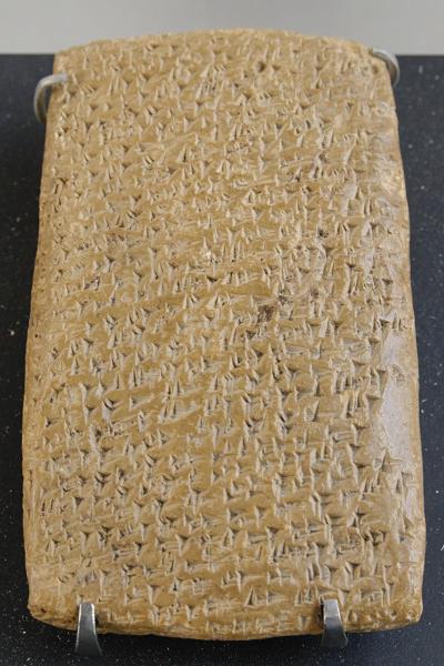
One of Tell Amarna letters (Louvre Museum, Public domain CC 2.5) Cuneiform writing on a clay tablet.
- Iron Age I (1200-1000 BC):
Shortly after the destruction of the Canaanite city, the new Israelite settlers rebuilt the city above the debris. They used the same architecture plan, laying the floors above the rubble of the earlier rooms.
Scholars identify this settlement as Biblical Jabneel, a southern border town of the Naphtali tribe (Joshua 19:32, 33):
“The sixth lot came out to the children of Naphtali, even for the children of Naphtali according to their families. And their coast was from Heleph, from Allon to Zaanannim, and Adami, Nekeb, and Jabneel, unto Lakum; and the outgoings thereof were at Jordan”.
Adami/Nekeb is agreed by many scholars to be Tel Adami. The next settlement (Jabneel) in this list is identified as Tell en-Naam (Tel Yin’am) north of modern Yavne’el. Then, proceeding eastward along Jabneel/Yavne’el stream, the border hits Lakum (Horvat Kush), before reaching to the Jordan river which is 1km east of Horvat Kush.
- Iron Age IIa (1000-925BC):
The archaeologists unearthed 2 structures in Area B (West side of the mound). In these rooms was an oil press with olive pits, and 43 loom weights used in the textile industry. Among other findings, they found a uniquely decorated knife and a rare conic seal engraved with a pair of long horned animals facing each other, each bearing a human figure on their backs.
Biblical Map:
The cities and roads during the ancient periods, up to the Roman period, are indicated on the Biblical Map below. The area north of Jabneel was allotted to the Naphtali tribe, while the area south of the site was Issachar territory.

Map of the area around Yin’am/Jabneel – during the Canaanite and Israelite periods (based on Bible Mapper 3.0)
Ancient roads:
The road along Yavne’el valley gorge was one of the major roads that descended to the Sea of Galilee basin during the Bronze and Iron ages. It connected west to east along these stations: Akko, via Hannathon, down thru the pass as Tel Adami (“Adami, Nekeb”), passing Tel Yin’am (“Jabneel”), down along the south bank of Yavne’el valley and passing near Horvat Kush. This route reaches Tel Ubeidiyeh (Beth Shemesh) in the Jordan valley and the river crossing at that point. According to D. Dorsey (“Roads and highways of ancient Israel”, p. 105-106, route “T1”) this Bronze/Iron age route, parallel to the route near Horns of Hittin (Madon?), made the descent shorter.

Caravan descending along the Adami-Nekeb pass – AI generated by Stable Diffusion
The ancient road (“T1”) was also used in later periods up to last century. The PEF surveyors wrote about an ancient road that passes near Kefr Sabt (near Adami-Nekeb) and continues down to Yavne’el valley. The Ottoman period road (Darb el-Hawarne – way of the Horan) passed here, exporting wheat on camels from the Golan to the port of Acre. (Volume 1 pp. 379-380):
“Another great road runs east and west across the sheet. It runs from ‘Akka to Tiberias. Passing over the low hills south of Rummaneh, it enters the plain north of Kefr Kenna, where it is joined by the road from Nazareth, which also shows traces of antiquity. Passing over the watershed close to esh Shejerah [BW: today’s Ilaniya], it descends to the broad plains on the east. After descending the first step of the series of terraces above Tiberias, near Kefr Sabt [BW: across Adami] the road divides, one branch running straight across the plain, and down the second step, to Tiberias ; the other descending the Sahel el Ahma [BW: shore of the lake], and emerging by the pass at its mouth. This is the great road used by the Bedawin and Druses, who bring barley from the plains of the Hauran to market at ‘Akka ; and in the autumn long strings of camels laden with barley are continually seen passing along it”.
- Persian period (539-332 BC)
During this period there was an extensive settlement activity. Two settlement layers were found during this period. A large building with 1m wide walls was unearthed in area B (on the western side of the mound). Another two story rectangular building was built on its north side.
- Hellenistic period
The city was abandoned during this period.
- Late Roman, Byzantine periods (4th-7th century)
The upper level of the mound was settled during this period.
A well preserved ritual bath (miqveh) with 6 steps was found in area C (southern side of the excavations), indicating a Jewish settlement. This 6th century plastered bath is the only structure on the mound that was built with hewn stones. Another structure was built over parts of the ritual bath, but the archaeologists could not determine its date of construction.
During the Roman and Byzantine period the Jewish population expanded beyond the capacity of the mound. Therefore, the population moved to Kfar Yemma, a town 1.8km south of Yin’am, situated on the foothills of Mt. Yavneel. The Finnish archaeologist Aapeli Saarisalo surveyed the site in 1927 and described it in his book (“The Boundary between Issachar and Naphtali”, pp. 46-48).
- Later periods
Destruction, nature and extensive farming activities changed the site considerably over the years, cutting sizeable areas around the site. However, the foundations of the Iron Age settlement are still found under the mound.
-
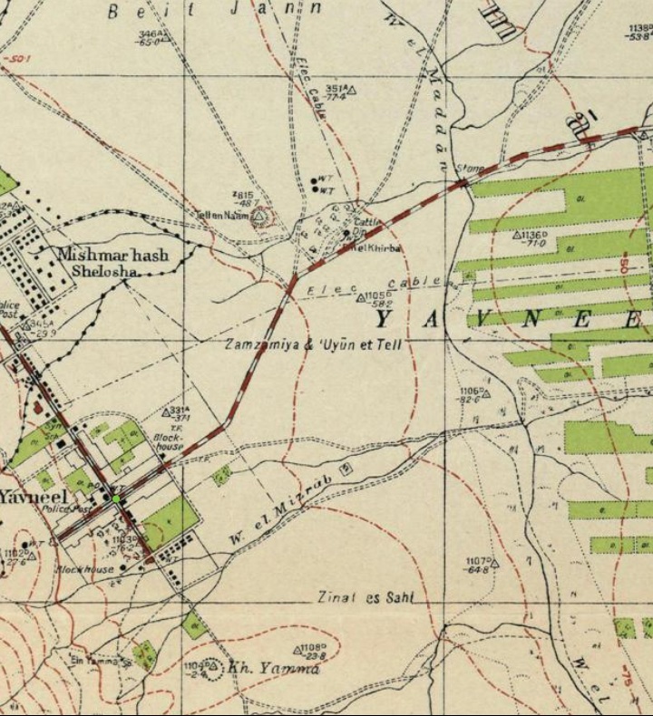
Ottoman period
The site was examined in the PEF survey (1866-1877) by Wilson, Conder and Kitchener. A section of their map is seen here, with the site marked “Tell en Naam”. It is located east of ruins of Beit Jenn, on the side of the ancient Darb el-Hawarne road (double dashed line) that enters to the Yavn’iel valley (Wadi Fejjas). The surveyors merely wrote about the site (Volume VI, p. 417): “Tell en Naam — Small artificial mound, with remains of basaltic ruins on the top ; several springs near”. They identified Biblical Jabneel in nearby village Yemma, based on the Talmudic identification. (Vol VI, p. 363): “Jabneel (Josh. xix. 33).—Called later Caphar Yama (Talmud, Jer. Megilla, 70d). The present ruin Ycmma, south-west of the Sea of Galilee”.

Part of Map sheet 6 of Survey of Western Palestine,
by Conder and Kitchener, 1872-1877.
(Published 1880, reprinted by LifeintheHolyLand.com)
- British Mandate period
The site was first surveyed by the Finnish archaeologist Aapeli Saarisalo in 1927. In his book (“The Boundary between Issachar and Naphtali”) he reported about his limited excavation and findings at the site named Tell en-Na’am (pp 44-45). This is a summary of his survey:
Tell en-Naʿam is a small, round artificial mound about 1.5 km east of Khirbet Beit Jinn and 0.5 km northeast of Yavneʾel. It stands 12 m high and about 360 m in circumference, built atop a low natural ridge that slopes gently north and northeast, and more sharply south toward the road. Surrounding debris and sherds extend over 100 m beyond the mound, indicating a wide area of ancient occupation. The spring of ʿEn Tell en-Naʿam lies 200 m to the south, in a marshy environment, and the ancient Darb el-Hawārneh road passes just southwest of the tell — a strategic location linking the Jordan Valley and Galilee uplands.
Saarisalo saw piles of small basalt stones and Arabic tombs on the summit, each marked by typical stone circles. Both Arab villagers and Jewish settlers were removing soil from the tell for construction, fertilizer, and brick-making, leaving deep cuttings that exposed archaeological layers — threatening the mound’s preservation. In one such section he found a human skeleton, still largely intact. A long section on the east side revealed three thick ash layers (about 3 cm each), rich in Late Bronze Age sherds, overlain by rough stone foundations — possibly remains of buildings.
Local settlers found two stone vessel fragments: One coarse, thick piece with raised hemispherical knobs on the base; Another, smoother and thinner, decorated with grooves and projecting rings, perhaps used for grinding grain, similar to examples from Megiddo. They also found a sandstone ball (6 cm wide) with a deep central dent, likely a spindle whorl rather than a weight, and a 40 cm tall Hellenistic jar (broken in a treasure-hunting attempt).
From the exposed layers and sections, Saarisalo collected abundant sherds from a broad range of periods: Early, Middle, and Late Bronze Ages; Early Iron I; Hellenistic and Roman periods. The Bronze Age sherds included: Painted pieces with brown and red-brown stripes; Jagged or dented rims; A handle incised with a palm-leaf motif. The Hellenistic pottery consisted of thin, yellowish wares decorated with smooth, glazed-like red and brown striping in alternating bands — showing advanced craftsmanship.
Saarisalo concluded that Tell en-Naʿam was a multi-period settlement with continuous or recurrent occupation from the Early Bronze through Roman times, possibly serving as a roadside settlement or local administrative post due to its proximity to the Darb el-Hawārneh route and the spring. He also warned that uncontrolled digging and soil removal were rapidly destroying the tell — making it one of the earliest recorded notices of site destruction by modern activity in the Galilee.
Saarisalo also examined another site just 1km south east of Yin’am – named Ayun Horeah. It is situated on the west bank of Nahal Mizrab. The site appears on the Ottoman period map as a spring, but Saarisalo wrote that it was a mistake. The mound is “a small artificial mound with a circumference of about 210m”. He found pottery of the Late Bronze and Iron 1. We also surveyed that site, and dated the site to Bronze and Iron Age.
A section of the 1940s British map shows the area around the site, which is marked with a circle and named “Tell en Naam”.
The site is situated in the fertile Yavn’el valley. A number of routes are marked passing near the site, and a paved road connected the farming village of Yavneel to Tiberias (going the north east). Wadi el Maddan, passing in the middle of the valley, is the upstream side of Wadi Fejjas (Nahal Yavneel).
British survey map 1942-1948 – https://palopenmaps.org topo maps
License: public domain under the UK Copyright, Designs and Patent Act 1998
- Modern Period
The farming settlement of Yavneel was founded in 1901.
The site of Tel Yin’am was excavated in years 1975-1989, headed by H. Liebowitz.
During our visits to the site we attempted to understand its structure and history.
Photos:
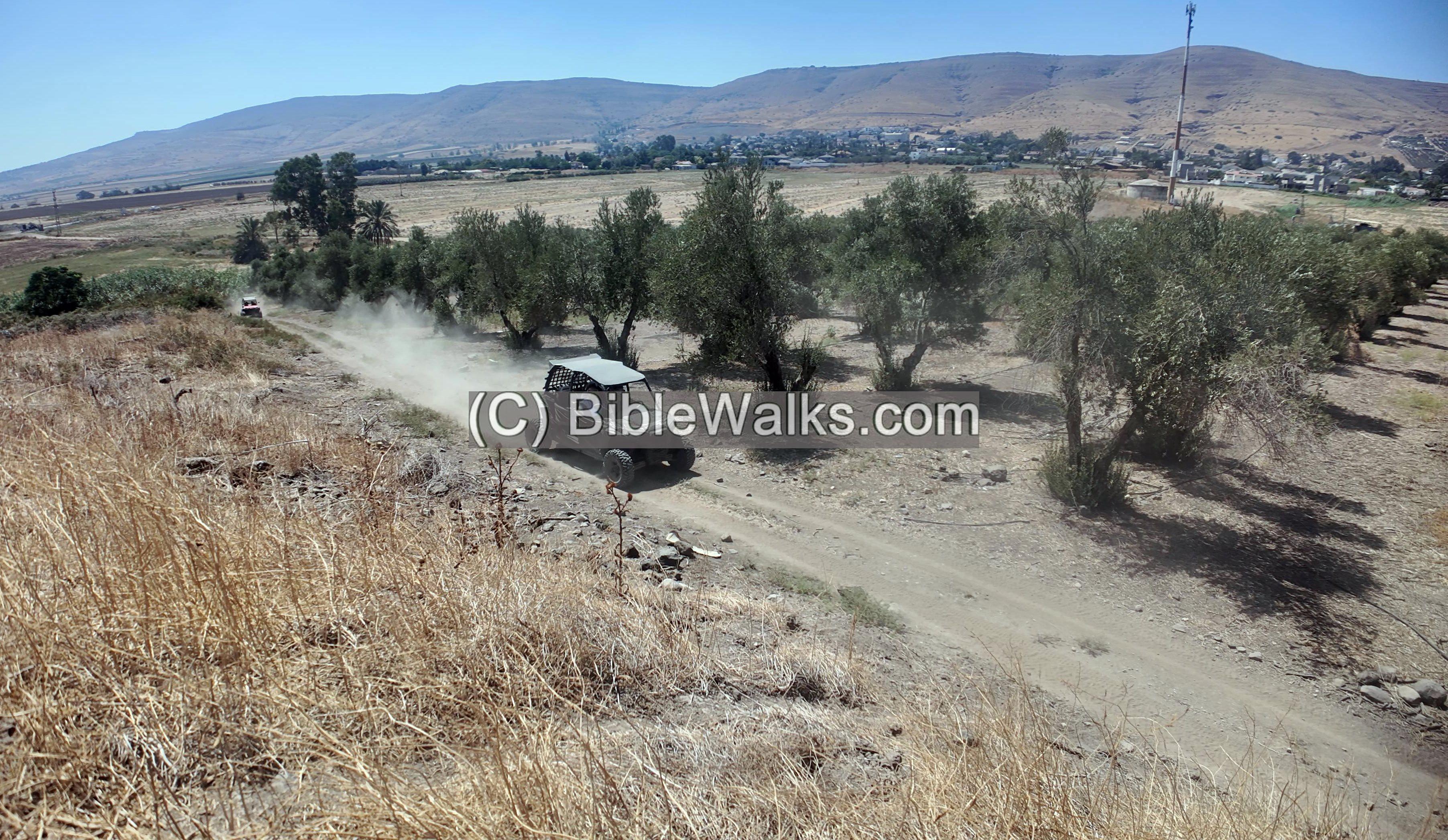
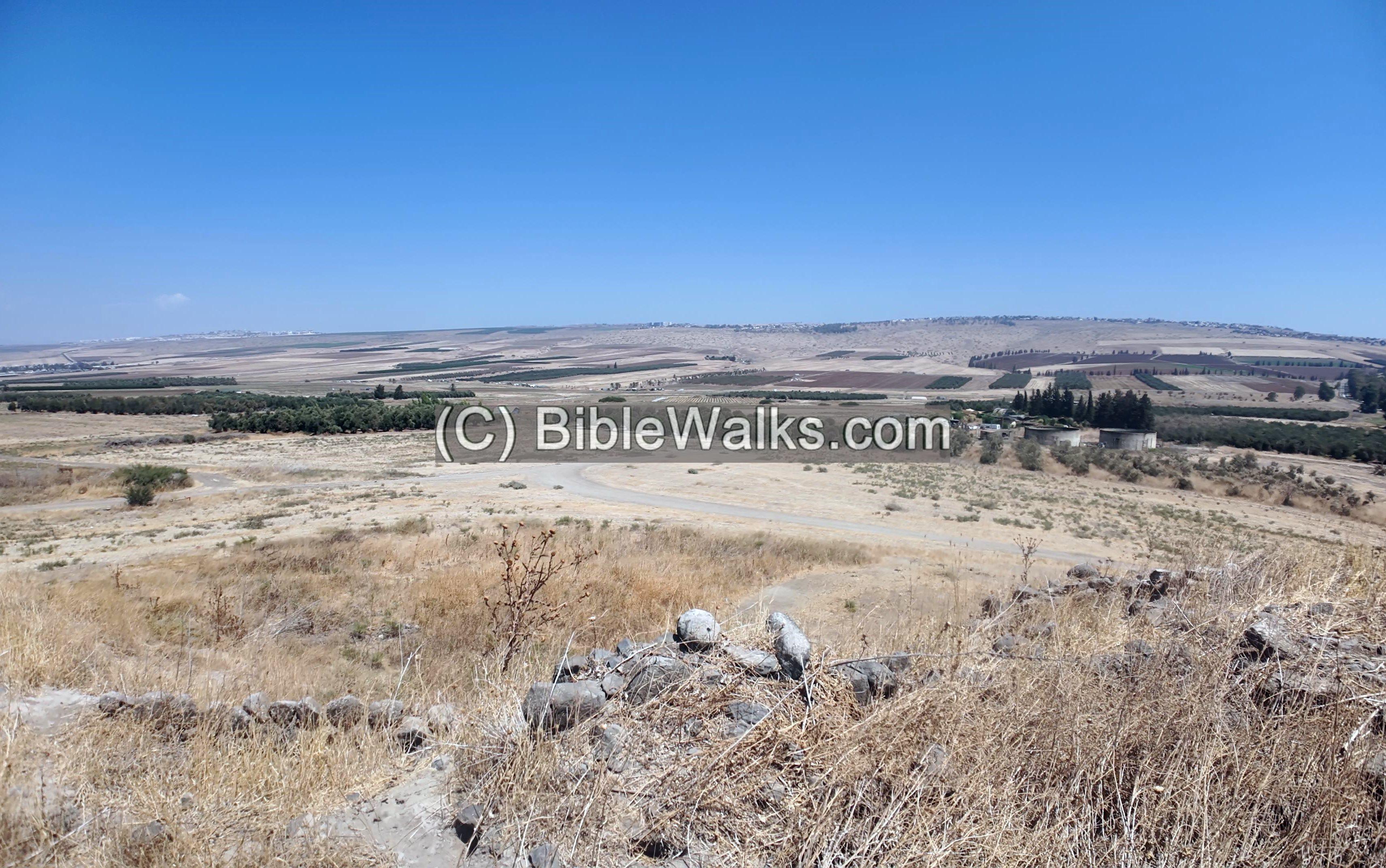
Off-road vehicles now traverse the Yavne’el Valley, taking in its scenic landscape. In antiquity, this valley gorge served as one of the main routes descending into the Sea of Galilee basin during the Bronze and Iron Ages. The road linked west to east, running from Akko through Hannathon, down the pass at Tel Adami, past this site Tel Yinʿam, along the Yavne’el stream eastward, passing Horvat Kush, and finally reaching the Jordan River.
Click on the photos to view in higher resolution…
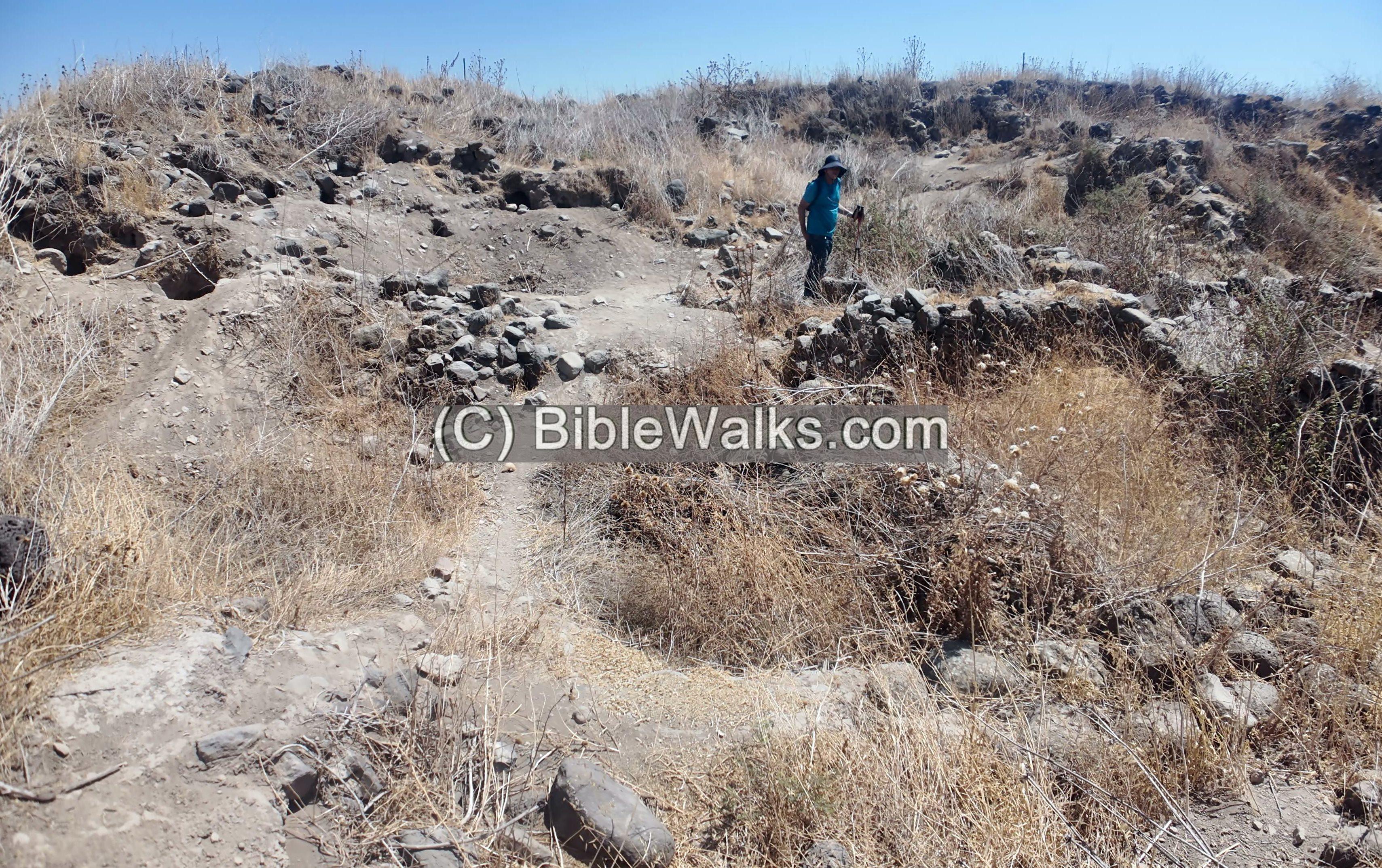
The mound was formed through a sequence of settlement layers, each built upon the ruins of the one before.
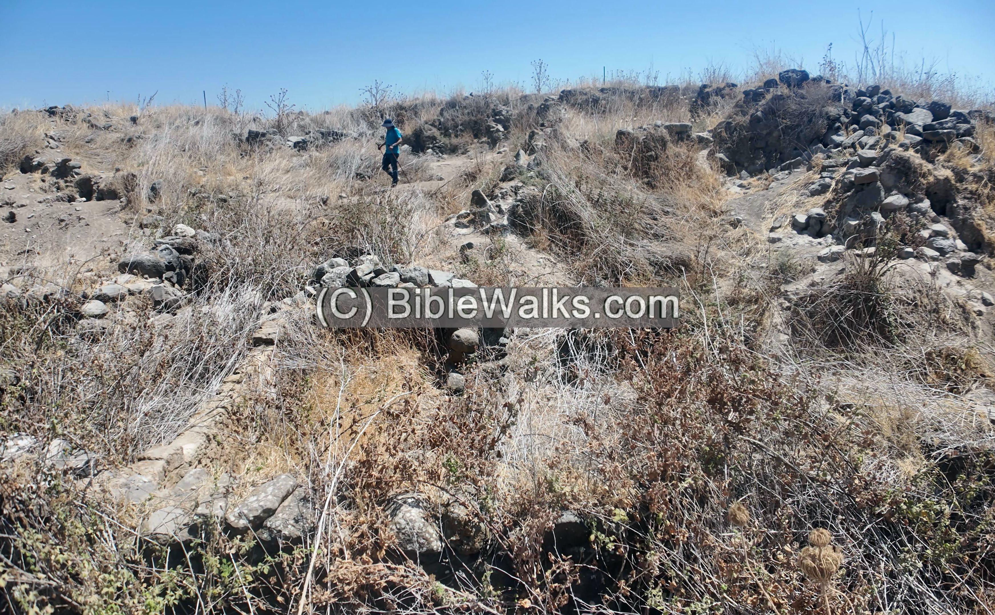
The excavations were conducted on 3 areas on top of the site: A (north), B (west) and C (south). Areas B and C are seen here from the south side of the mound.
The earliest occupation began on the natural hilltop, but in the Late Bronze Age II (ca. 1300–1200 BC) a substantial Canaanite town emerged. At its center stood a prominent building, probably the governor’s residence, with at least eight rooms serving domestic and storage functions. Excavators uncovered a wealth of finds inside: ceramic and basalt vessels, cylinder and stamp seals, pendants, and beads. Most striking was the discovery of a rare iron-smelting furnace. Surrounding this central complex were additional structures, all destroyed in a catastrophic conflagration at the close of the period, marked by heavy layers of ash, burnt mudbricks, charred timbers, and fire-cracked stones.
In the Iron Age I—the era of the Judges—new settlers built atop the Canaanite ruins. This phase is often identified with the Biblical city of Jabneel, on the southern border of Naphtali. During Iron Age IIa (ca. 1000–925 BC), in the time of the Northern Kingdom, the town expanded again, only to be destroyed once more.
The mound saw extensive reoccupation in the Persian period (539–332 BC). After a gap, settlement resumed in the Late Roman and Byzantine periods (4th–7th centuries CE). From this final phase, archaeologists uncovered a plastered Jewish ritual bath (miqveh) with six steps in Area C. This was the last occupation level on the mound, after which the site was permanently abandoned.
Below is a view from the summit towards the north. The vast and fertile valley of Yavne’el stretches to the north west. Mt Poriya is located on the ridge, and Tiberias is hidden beyond it.
Videos:
![]() This video summarizes a field survey of the site by BibleWalks staff, conducted on September 2025.
This video summarizes a field survey of the site by BibleWalks staff, conducted on September 2025.
A drone captured aerial views of the mound, recorded on September 24, 2025:
Etymology – behind the name:
* The name of the site:
- Yin’am – modern Hebrew name, means: “Will be pleasant”. Based on proverbs 2:10: “כִּי-תָבוֹא חָכְמָה בְלִבֶּךָ; וְדַעַת, לְנַפְשְׁךָ יִנְָעם” , meaning: “When wisdom entereth into thine heart, and knowledge is pleasant unto thy soul;”
- Tel En Naam – Arabic name
- Yavne’el (Jabneel) – Hebrew for “God will build”; (Joshua 15:11): “And the border went out … unto Jabneel”
* The name of the valley and stream:
- Nahal Yavne’el – Hebrew: Yavn’ele stream; named after the Biblical and Modern settlement
- Wadi el Fejjas – Arabic name of Nahal Yavn’el; PEF dictionary: “The valley of the haughty oppressor”.
Links and references:
* External links:
- “The Boundary between Issachar and Naphtali” – Aapeli Saarisalo – 1927 pp. 50-51 – reviews the site
- “The new encyclopedia of archaeological excavations in the Holy Land” [1992 E. Stern editor, Volume 2 pp. 583-585]
- Yavne’el, Tel Yin‘am, Final Report, Edwin C.M. van den Brink – HAESI Volume 129 Year 2017
-
The early Bronze Age pottery from Tel Yin’am, Israel Univ Texas at Austin
- Tel Yin’am I: The Late Bronze Age: Excavations at Tel Yin’am, 1976-1989. Harold A. Liebowitz
- Tel Yin’am II: The Iron Age: Excavations at Tel Yin’am, 1976-1989. Harold A. Liebowitz
- Timeline of Yavne’el, Israel – The First Century 1901-2001
- The Amarna Letters. Johns Hopkins University Press. William L. Moran (1992)
- Did trade stop in the early Iron Age? Aren M . Maeir, University of Minho, Academia 2023
* Internal links:
- Jordan Valley Archaeological survey– Biblewalks survey summary
- Miqveh – installations in the Holy Land
BibleWalks.com – walk with us through the sites of the Holy Land
Karm er-Ras<<<—previous site—<<<All Sites>>>—next Lower Galilee site—>>>
This page was last updated on Oct 12, 2025 (add Yemma, summarize Saarisalo)
Sponsored Links: