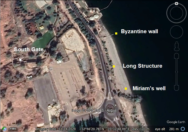
Remains of “Miriam’s well”, “Long Structure”, and the southern Byzantine city wall.
Home > Sites > Sea of Galilee> Tiberias> Miriam’s well, Long structure and Byzantine wall
Contents:
Background
Location
History
Photos
* Aerial Views
* Video Tour
Links
Background:
Along the beach east of the Roman/Byzantine city are a 3 historic sites: remains of columns, named after “Miriam’s well”; the northern part of the “Long Structure”; and the southern Byzantine city wall.
Location:
An aerial photo is shown below, indicating the major points of interest along the beach known as “Miriam’s well”. The Byzantine city wall is the eastern section of the south wall that passes along the southern gate. The “Long Structure” is visible along the west side of the beach. The columns of “Miriam’s Well” are seen on the south side of the beach.
History:
(a) Miriam’s Well:
- “Miriam’s Well” – Jewish tradition – Byzantine period
In rabbinic and medieval Jewish lore, Be’er Miriam (“Miriam’s Well”) was the miraculous spring that accompanied the Israelites in the desert in the merit of Miriam, the sister of Moses and Aaron (Numbers 20:1–2; midrashic expansions in B. Ta’anit 9a):
“Then came the children of Israel, even the whole congregation, into the desert of Zin in the first month: and the people abode in Kadesh; and Miriam died there, and was buried there. And there was no water for the congregation: and they gathered themselves together against Moses and against Aaron”…
The tradition was that there was a rock that gave the water to save the people (Numbers 20:11):
“And Moses lifted up his hand, and with his rod he smote the rock twice: and the water came out abundantly, and the congregation drank, and their beasts also.”
Jewish travelers and pilgrims in late antiquity and the Middle Ages sometimes identified certain natural springs in the Galilee (and elsewhere) with that legendary source. The Tiberias spring likely received this name in that context — as a visible, perennial spring close to the city’s holy places.
The earliest source that places “Miriam’s Well” at Tiberias is the Jerusalem Talmud (4th–5th c. AD), where Rabbi Chaim Bar Bah tells the location of the well (Yerushalmi Ketubot 12:3, and parallel Kilayim 9:3):
“…one who ascends Mount Yeshimon and sees something like a small sieve in the Sea of Tiberias, that is Miriam’s Well.”
Shortly after, a Land-of-Israel midrash adds a more precise landmark in Tiberias (Vayikra (Leviticus) Rabbah 22:4):
“…it is opposite the middle gate of the ancient synagogue of Tiberias.”
Note that to date there was no Byzantine period synagogue exposed in the area near the beach.
- “Miriam’s Well” – Jewish tradition – Middle ages
The medieval tradition holds that the miraculous well associated with Miriam is to be identified with a feature of Lake Kinneret — a tradition repeated by later authors and by kabbalists.
In his travelogue (Masa’ot Yaakov), Jacob ben Natanel writes “The Kinneret is sweet as honey, the Jordan flows through it, Miriam’s Well is in it.” This clearly identifies a spring “in” the lake, not on the shore—reflecting an older tradition that the Well of Miriam arises from under the water.
During the 16th century, the Holy Ari, Rabbi Isaac Luria (1534–1572), the great kabbalist of Safed, gave a very specific location for Miriam’s Well. His teaching is preserved by his disciple R. Ḥayyim Vital in Shaʿar HaGilgulim (and repeated in Sefer Ḥaredim and later pilgrim guides). Luria said that Miriam’s Well still existed in his own time and could be seen in Tiberias. He identified it as a spring of sweet water on the southern shore of Tiberias, close to the hot springs of Hammat. Pilgrims report that Luria taught: “The Well of Miriam rests in the Sea of Tiberias, and it appears on the Sabbath eve, opposite the synagogue by the hot baths.” R. Ḥayyim Vital records visiting the site with the Ari and describes how the Ari pointed it out. Later travelers (17th–18th c.) note that people believed the well rose to the surface on Fridays, visible like a rolling sieve or a swelling in the water.
This Middle Ages tradition places the well 700m south of the beach. Although the waters near Hammat are not drinkable and not sweet, there could have been another spring with sweet waters.
- “Miriam’s Well” – Christian and Muslim tradition
These traditions were also adapted by Christians and Muslims: In Christian tradition, the name “Miriam” (Greek Maria) is also linked to Mary, the mother of Jesus. Pilgrims in Byzantine and later periods often reinterpreted local holy wells and springs in association with Mary’s miraculous deeds or healing powers. A spring by Tiberias, close to churches and monasteries, could be naturally linked to Mary in local lore. In local Muslim tradition, certain freshwater sources are linked with prophets’ families or saintly women, including Maryam (Mary). The healing quality of spring water often played into this.
- Spring’s location?
According to these traditions, the spring emerges right by the southern city wall of Byzantine Tiberias, next to the shore. Because it was a constant source of drinkable water, it was a landmark for residents, travelers, and pilgrims — making it a natural candidate for a name steeped in religious symbolism. However, looking up the maps, we couldn’t find a spring that is currently near the site. Nevertheless, a valley flowing thru the south gate area to the beach could have had waters that originated from a spring uphill (‘Ain Berniki).
In short: the name “Miriam’s Well” is a later (Byzantine onward) devotional naming of a real spring, merging biblical Miriam’s legendary well with Christian/Muslim Mary/Maryam traditions, and cemented by its prominence on the pilgrim route into Tiberias.
(b) Byzantine city Wall
A new Byzantine wall was constructed in the 6th-7th century, and included the city’s southern gate. The Israel Antiquities Authority notes that “the city wall was erected by the emperor Justinian in the sixth century AD.” The Byzantine historian Procopius (lived in the 6th century) lists it explicitly in his accord of Justinian’s buildings that he erected: “the wall of Tiberias.” (as per Justinian’s works in Book V, ch. 9).
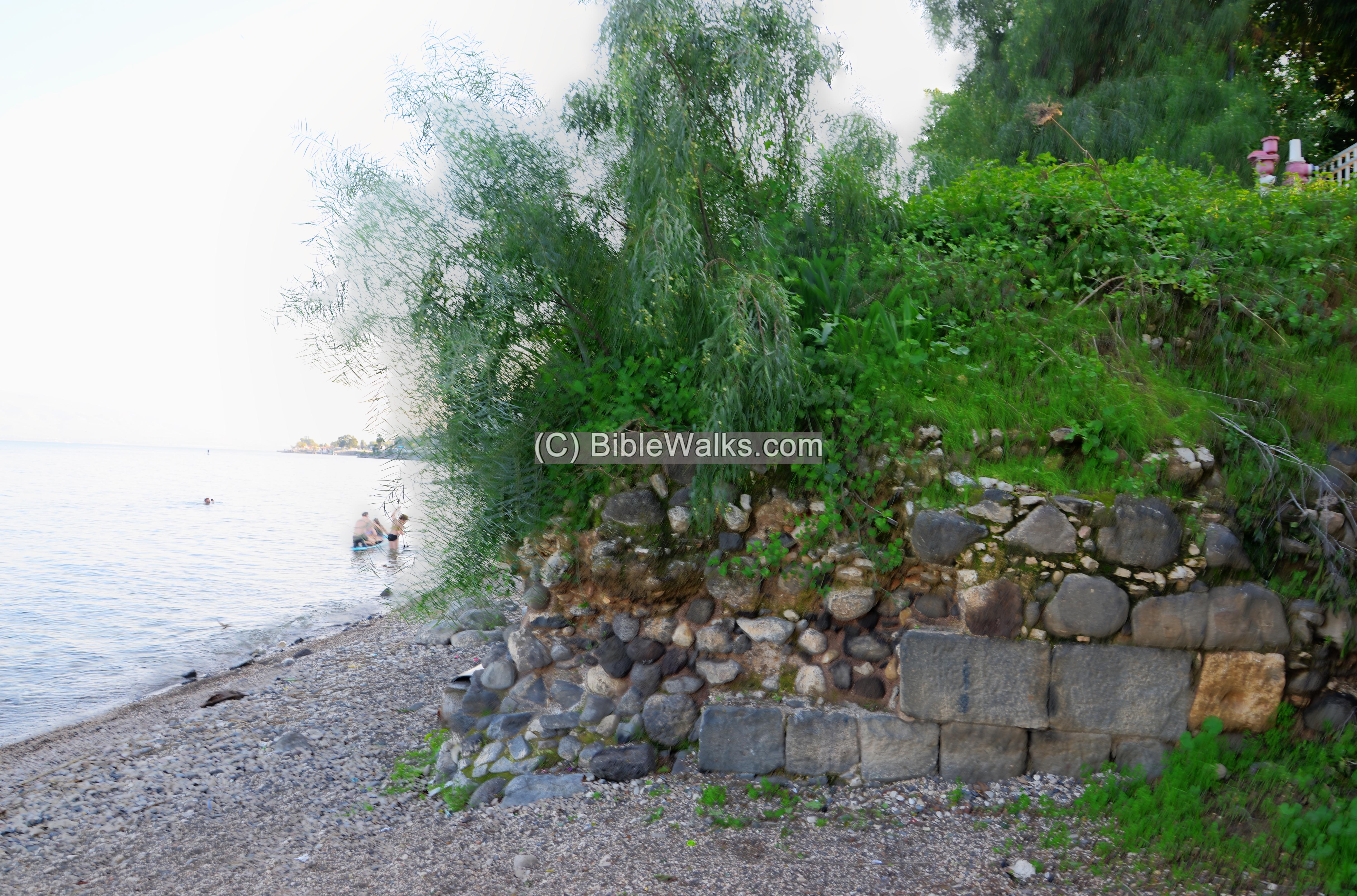
A section of this wall extended into the lake, and is seen on the northern section of “Miriam’s Well” beach. The extension into the sea was intended to protect the city from a invasion along the beach during the autumn season when the water levels in the lake drop.
The wall that was built in the 6th century CE under Justinian enclosed roughly 1.5 km along the lakefront and inland. It enclosed an area of 2.8km and enclosed an area of 750 dunams (75 hectares).
(c) Long Structure:
The Long structure is an ancient construction that is over 73m long, running along the west side of the beach. Recent archaeological investigations identify this elongated structure as part of a complex of constructions extending south beyond the Byzantine city wall, but not necessarily a harbor.
-
The long structure runs on a north–south axis along the beach, adjacent to:
-
A segment of the Byzantine city wall that extends into the lake,
-
Several robbed basalt columns aligned parallel to it.
-
-
While earlier scholars had proposed that these stone-built features belonged to a harbor capable of accommodating ships, new excavations (E. Nantet, 2020–2022) suggest a different interpretation:
-
The structures likely served other functions, though fishing vessels may have moored in the area even if no formal harbor remains are visible.
-
So, in short, the long structure is neither clearly a quay wall nor part of a classical port. Rather, it is a multi-phased, reconstructed waterfront feature, likely adapted over time as the lake’s level fluctuated and urban needs shifted from the late Byzantine into the Early Islamic periods.
Ottoman period:
In David Roberts’ monumental series The Holy Land, Syria, Idumea, Arabia, Egypt and Nubia (1842–1849), where Louis Haghe (often spelled Hague) turned Roberts’ 1839 sketches into hand-colored lithographic plates. One of the plates depicts the scene with drums clearly visible—likely column drums lying on the ground, a common feature in ruins Roberts drew. These might explain the drums found on the south section of the Miriam’s Well beach.
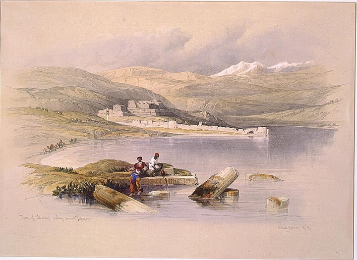
Photos of Library of congress – View of Tiberias from the south – David Roberts – Louis Haghe, 1842
Ḥayyim Vital (1542–1620), foremost disciple of Isaac Luria (the Ari, 1534–1572), records that he once sailed with his master on the Sea of Galilee. They moored at a spot on the southern beach of Tiberias, where standing columns were visible in the water/shoreline. These columns were popularly identified as belonging to the ancient synagogue of Tiberias.
This identification is explicitly mentioned by Zemah ben Solomon Duran (printed 1712, Sefer Zemah David, p. 7), who transmits the Vital/Luria account. Zemah ben Solomon Duran (Zemah, 1712), Sefer Zemah David, Amsterdam, p. 7) describes R. Ḥayyim Vital’s testimony that he and the Ari had been by boat on the Kinneret, came ashore at the columns, and that these were held to be the ruins of the synagogue. This is one of the earliest published references that connects the visible columns at Miriam’s Well Beach (the so-called “long structure”) with the memory of a synagogue in Tiberias.
Archaeologists and historians (e.g. Zeev Weiss, Katia Cytryn-Silverman, E. Nantet, etc.) note this tradition when discussing why the submerged ruins were remembered as a synagogue in early modern times, even though no stratigraphic evidence yet confirms a synagogue on that exact spot.
The persistence of this synagogue identification reflects a strong local memory or legend attached to the standing columns by the 16th–18th centuries.
Archaeologist Y. Hirschfeld suggested that these columns may have been the supporting pillars of one of the fatimid pleasure houses that were built inside the lake.
Modern period:
The beach remained untouched until the modern construction of the 1980s, as seen in this 1934 photo taken from the south of Tiberias.
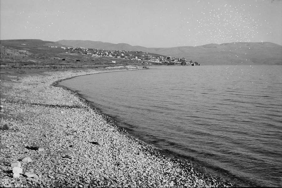
Photos of Library of congress – View of Tiberias from the south; American Colony, 1934
Recent survey:
The beach was investigated by the South Tiberias Lake Area (STLA) project 2020-2022 excavations, as reported by E. Nanet. The photos in the section below are from our 2 visits to the site – on Feb 2021 and Aug 2025.
Photos:
(a) Miriam’s well Beach
A stone marks the location of Miriam’s Well (“בארה של מרים”) along Tiberias coastal highway (Kaplan Boulevard). The marker is part of the Sanhedrin trail, a planned 70-kilometer interactive hiking path in the Lower Galilee, designed to connect historical sites associated with the Sanhedrin. Sanhedrin was a Jewish legislative and judicial body during the Roman period (years 70-358 AD). It functioned as a supreme council and court of justice.
Click on the photos to view in higher resolution…
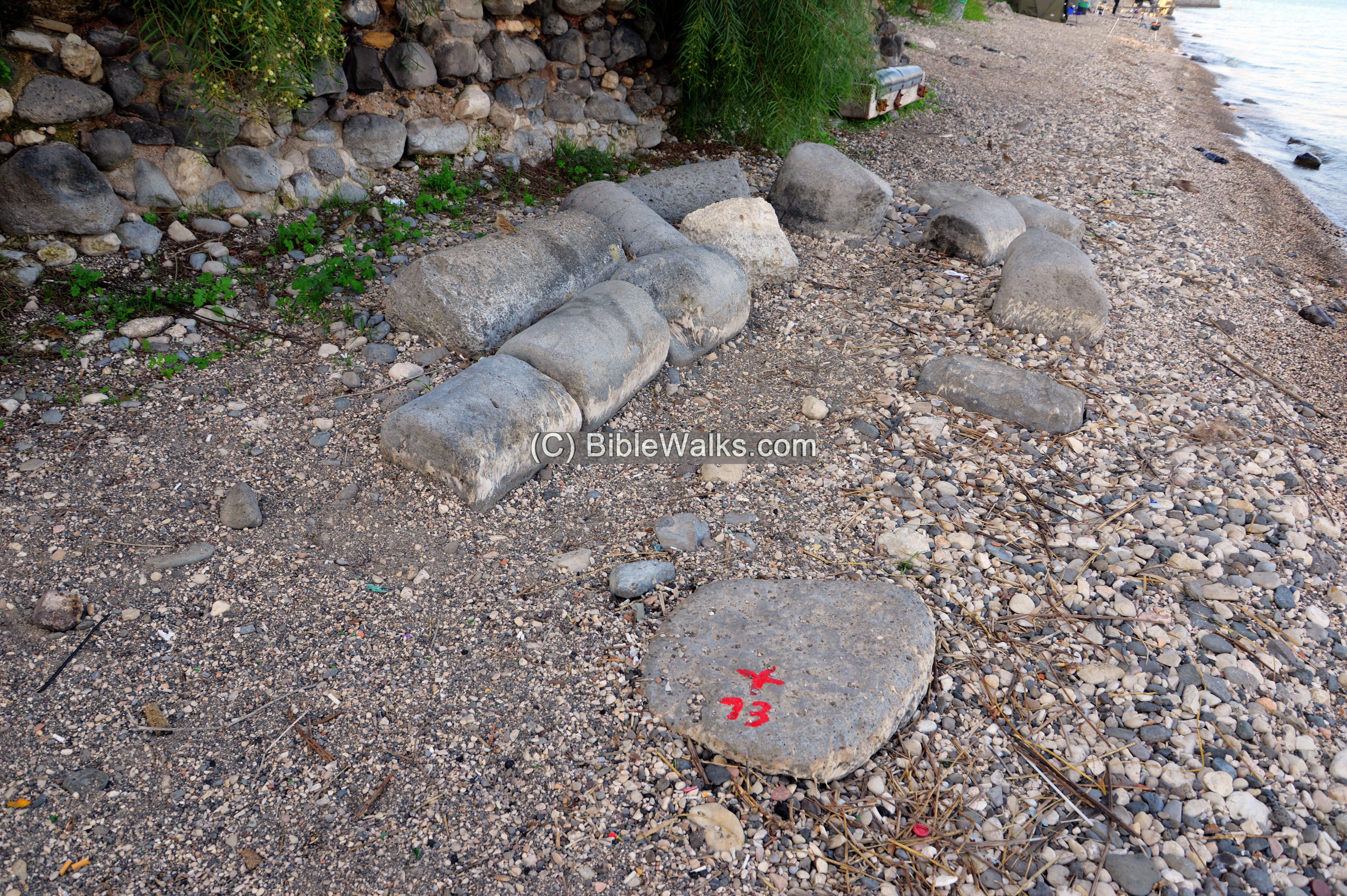
Another marker sign is on the beach, just below the location of the Sanhedrin trail marker. This round limestone is one of the drums found around this location.
Southern edge:
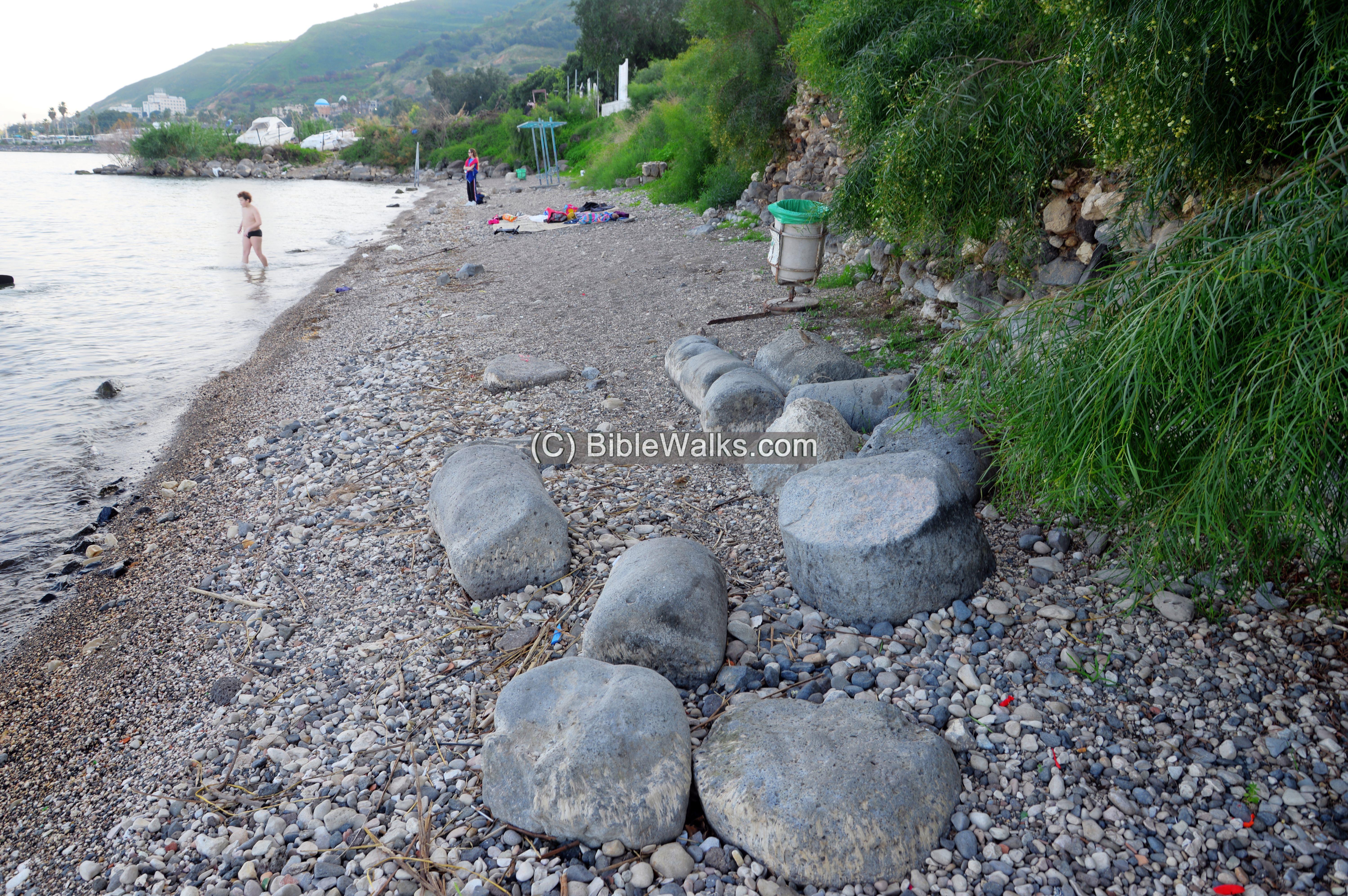
There are steps at this place that descend to the beach. The length of the beach from this southern edge to the Byzantine wall is 150m, and the width of the beach is about 7-20m depending on the seasonal level of the lake and the position along the beach.
On the southern edge of the beach are dozens of column drums that are found on the west side of the beach. The survey revealed that the columns are arranged in a relative close arrangement. The archaeologists therefore suggested that they were pillars that supported a structure that was built over the water, probably during the Fatimid caliphate (909–1171 AD) .
Some columns are seen embedded into the edge of the road on the west edge of the beach.
Another view of the columns along the edge of the beach:
Some of the drums or columns are located near the waters, or submerged, depending on the level of the lake. The level of the Sea of Galilee fluctuates based on the season and the year.
Here are more drums:
The surveyors found 41 drums in total. Their diameter vary between 35 to 90cm, and their heights between 20 to 90cm. Some are made of basalt (black) and some are limestone (white).
Another section of a column is hidden below the rubble on the southernmost section of the beach.
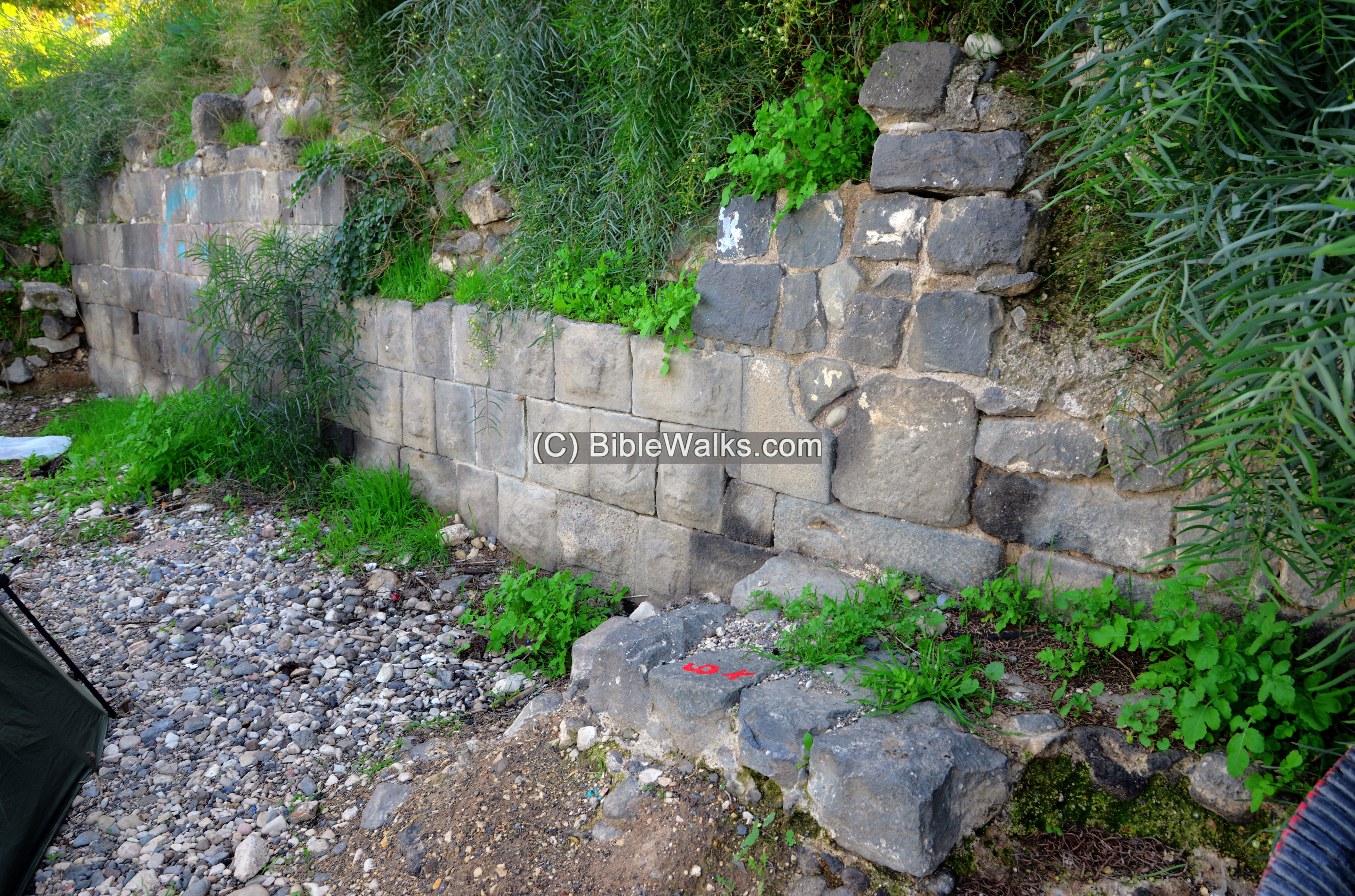
(b) The ‘Long structure’
The Long structure is an ancient construction that is over 73m long, running along the west side of the beach. Recent archaeological investigations identify this elongated structure as part of a complex of constructions extending south beyond the Byzantine city wall. It was probably built to add a protective structure to overcome the changing levels of the lake.
Southern edge:
At the southern corner of the structure contained two rooms that were separated by a wall.
Next to the corner is a perpendicular wall that extends from the retaining wall of the highway. Some of the stones embedded in the wall are reused sections of an aqueduct, such as seen here at the bottom of the wall. These aqueduct cylinders were probably dismantled from the Hippos (Sussita) aqueduct across the lake, or from the Berniki aqueduct to the west of the Byzantine city.
Corner:
In the middle of the structure is a corner of the wall, where the structure turns inwards.
A closer view of the corner, with large basalt stones (and one limestone) on the base, and smaller stones above it:
A group of fallen columns are seen near the corner:
Another view, with a view towards the south:
On the northern section of the ‘long structure’ are remains of a door. A 40 cm high podium of two steps enabled to access the lake and beach. The podium is 2.55m wide and 1.33m long.
The wall on the south side of the door:
(c) Byzantine city wall
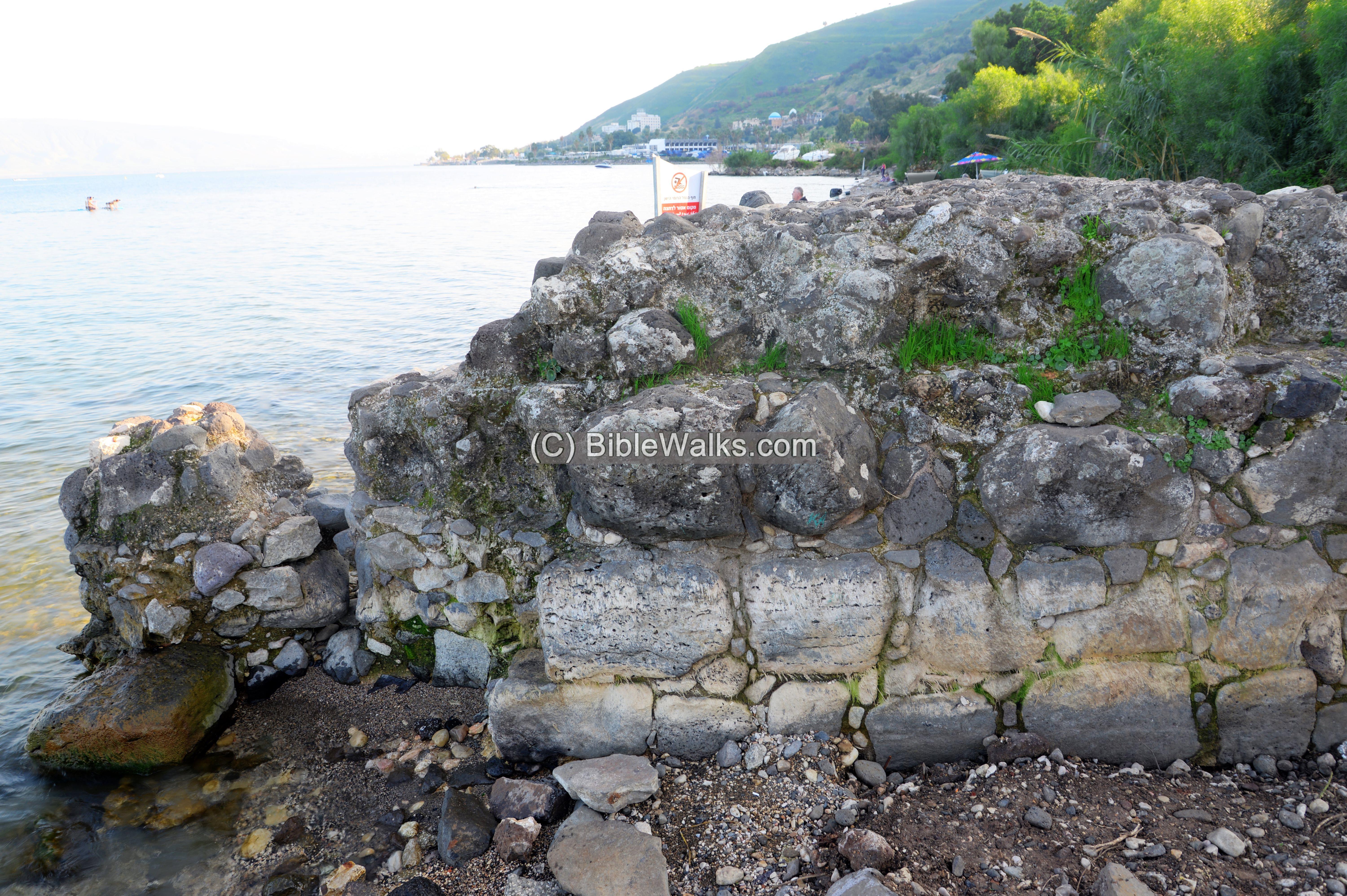
Miriam’s Well beach was actually located outside of the Byzantine walled city. On the northern side of the beach is the southern wall of the Byzantine city.
The wall was built in the 6th century CE under Justinian. It enclosed roughly 1.5 km along the lakefront and inland. It enclosed an area of 2.8km and enclosed an area of 750 dunams (75 hectares). It is a continuation of the wall dropping from Mt. Berniki and passing the South Gate to reach the shore at this point.
A section of this wall extended into the lake, and is seen on the northern section of “Miriam’s Well” beach. The extension into the sea was intended to protect the city from an invasion along the beach during the autumn season when the water levels in the lake drop.
The wall is deeply embedded into the beach, reaching more than 3m deep. It is built of large basalt blocks that were smoothed only on the exterior, and limestone blocks below. The interior of the wall is filled coarsely cut stones embedded in ancient concrete.
The wall connects on its west side to the wall on the side of the road. It is stepped towards the lake, as seen in the following view towards the south.
In the far background is Hippos/Sussita on the Golan heights, on the east side of the Sea of Galilee.
The wall continues submerged into the lake. The extension is 16m long, made of 6 concrete blocks and is built 35cm from the edge of the basalt wall. Each of these blocks are 2.3m long. The most eastern block was built under the low level of the lake that was at the time of its construction during the late Byzantine period.
(b) Video Tour
Visit the site with this 4 minutes video tour (visited July 2025).
Etymology:
- Miriam – the sister of Moses and Aaron (Numbers 20:1–2)
- Miriam’s well (Hebrew: Be’er Miriam) – a miraculous legendary spring
Links:
* External:
- Miriam’s Well: Unravelling the Mystery Chabad.org – about the Biblical side of the well
-
A Harbour in South Tiberias? Summary of the 2020–2022 Excavations at the Miriam’s Well Beach (South Tiberias Lake Area Project) – E. Nantet May 2025
-
Tiberias and Hammat Tiberias, Berenice Channel – HAESI V130 2018
Tiberias sites in BibleWalks:
BibleWalks.com – enter the gates of the Holy Land
Basilica <<<–previous site—<<< All Sites>>> —-next Sea of Galilee site –>>> Berniki Hill
This page was last updated on Aug 19, 2025 (new site)