This overview page presents ancient sites in the area of the modern city of Rosh Ha-Ayin.
Home > Sites > Shefela > Rosh Ha-Ayin (overview)
Contents:
Background
Location
History
Sites
* Tel Afek
* Migdal Afek
* Izbet Zartta
* Horvat Te’ena
* Iron Age Farmhouse
* Iron Age Station
* Umm el Bureid
* Umm el Hammam
* Shilo 3 farmhouse
* Qesem Cave
Etymology
Links
Overview:
This overview page presents ancient sites in the area of the modern city of Rosh Ha-Ayin, and points to the sites already published in BibleWalks.com.
Location and Map:
The following aerial view shows the points of interest that are reviewed in this page in the area around Rosh HaAyin.
The modern city was built between two major west-east routes (Wadi Rabah on the north, and Nahal Shiloh valley on the south), and a major north-south route on its west side. Modern highways use the same routes on the west side (highway 6) and north side (highway 5).

History:
Biblical periods:
Tel Aphek (Afek) is located on the west side of the modern city of Rosh HaAyin. It is strategically located on a pass along the north-south Via Maris, the ancient road that connected the regions north of Israel (Mesopotamia, Asia minor and Syria) to the south (Egypt). This narrow pass of 2KM was an ideal location for the ancient city, since the trade caravans had to pass at this site. The passage was blocked on both sides of the city: eastwards to the sea was the Yarkon river and its marsh lands, and westwards are the hills of Samaria. Through the city also passed the main road from Caesarea, the large Roman city, to Jerusalem, and from Aphek to Jaffa and the coastal parallel road to Egypt.
The cities and roads during the Canaanite, Israelite and Hellenistic/Roman periods are indicated on the Biblical Map below, with Afek/Antipatris in the center.

Map of the area around Afek/Antipatris – 15C BC through 1C AD (based on Bible Mapper 3.0)
Major Bronze/Iron Age roads passed Aphek in the area of modern Rosh HaAyin. According to David Dorsey (“The roads and Highways of Ancient Israel”, 2018, pp. 65-66, 165-177) the following roads crossed here:
- S6 (West-East, Aphek via Kfar Kassem to N1 – the National mountain highway)
- S7 (West-East, Aphek via Izbet Zartta, along Wady Rabbah to N1 – the National mountain highway)
- S8 (West-East, along Shiloh valley) – a route south of Migdal Afek
- I4/I7 (West-East, Jaffa to Aphek)
- I1 (Soth-North, Gaza to Ashdod, then Aphek)
- I10 (South-North, Ashdod to Lod, then Aphek)
- I12 (South-North, Ashkelon to Ekron, Gezer and northwards) – an alternative route, passing east of Izbet Zartta/Eben Ezer, 2km east of Aphek.
Other periods:
See the history of each of the sites in their specific web page.
Ottoman period:
Conder and Kitchener of the Palestine Exploration Fund (PEF) surveyed the area during the Survey of Western Palestine (SWP) in 1874-75. The map is a section of their survey results. On the left side of this section is Mejdel Yaba, at the area of Migdal Afek.
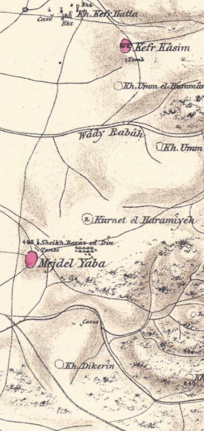
Part of map Sheet 14 of Survey of Western Palestine,
by Conder and Kitchener, 1872-1877.
(Published 1880, reprinted by LifeintheHolyLand.com)
Their report also described the importance of the fortress at this point (p 261):
“We may now turn to the military aspect of the question, and ask what would be the best line of defence for an army to take up on the plain to prevent the march of a force southward. To this there can be but one answer the line of the Nahr Aujeh [BW: the Meandering river – Nahal Yarkon]. From the fountains at Ras el ‘Ain [ BW: Rosh Ha’Ayin] to the sea the river is deep, unfordable for several months in the year, and has in several places marshy banks. It must thus have always presented a serious obstacle to the advance of an army, and one which no soldier acting on the defensive would neglect to make use of Between Ras el ‘Ain and the foot of the mountains there is but a comparatively narrow strip of level ground, forming a pass, through which any force advancing southwards must march, and one that could be easily closed by towers and a ditch. That the Crusaders were not ignorant of the military value of this feature is apparent from the ruins of the castles of Mirabel and Mejdel Yaba, guarding each flank of the pass ; and if Antipatris were at Ras el ‘Ain, Herod, in selecting the site, was no doubt influenced by military considerations”
- Modern Period
Rosh HaAyin – From Ma’abara to Modern City:
The city was established in 1949, shortly after the founding of the State of Israel, as a ma’abara (transit camp) for Jewish immigrants from Yemen, who had arrived in the massive airlift operation known as Operation Magic Carpet (1949–1950). These immigrants were settled near the historical site of Antipatris/Tel Afek, close to the Yarkon springs.
In the 1950s and 60s, the area gradually transitioned from tents and tin huts into permanent housing, and the town absorbed more immigrants, including Jews from North Africa and later from Ethiopia and the former Soviet Union.
The city’s name, Rosh HaAyin (“Head of the Spring”), reflects its proximity to the source of the Yarkon River, a historically strategic water source.
In the 1990s and 2000s, Rosh HaAyin underwent significant expansion, developing modern residential neighborhoods, schools, industrial zones, and infrastructure. It also benefited from its strategic location near major roads (Highway 6, Highway 5) and proximity to Tel Aviv and Petah Tikva.
Today, Rosh HaAyin is a growing city with a diverse population, blending its Yemenite roots with modern Israeli urban culture. It continues to expand with new housing projects and is part of Israel’s broader central metropolitan development.
Sites:
These are the sites that were reviewed in BibleWalks. More sites are scheduled to be reviewed.
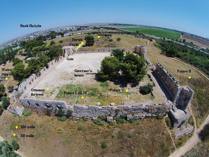
(a) Tel Afek/Aphek (Antipatris)
Tel Aphek (Afek, Antipatris) was a gateway on the main trade route from north to south. More than 6,000 years of successive cities have been built on the mound overlooking the springs of the Yarkon river.
Click on the photos to view in higher resolution…
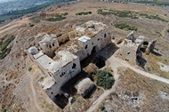
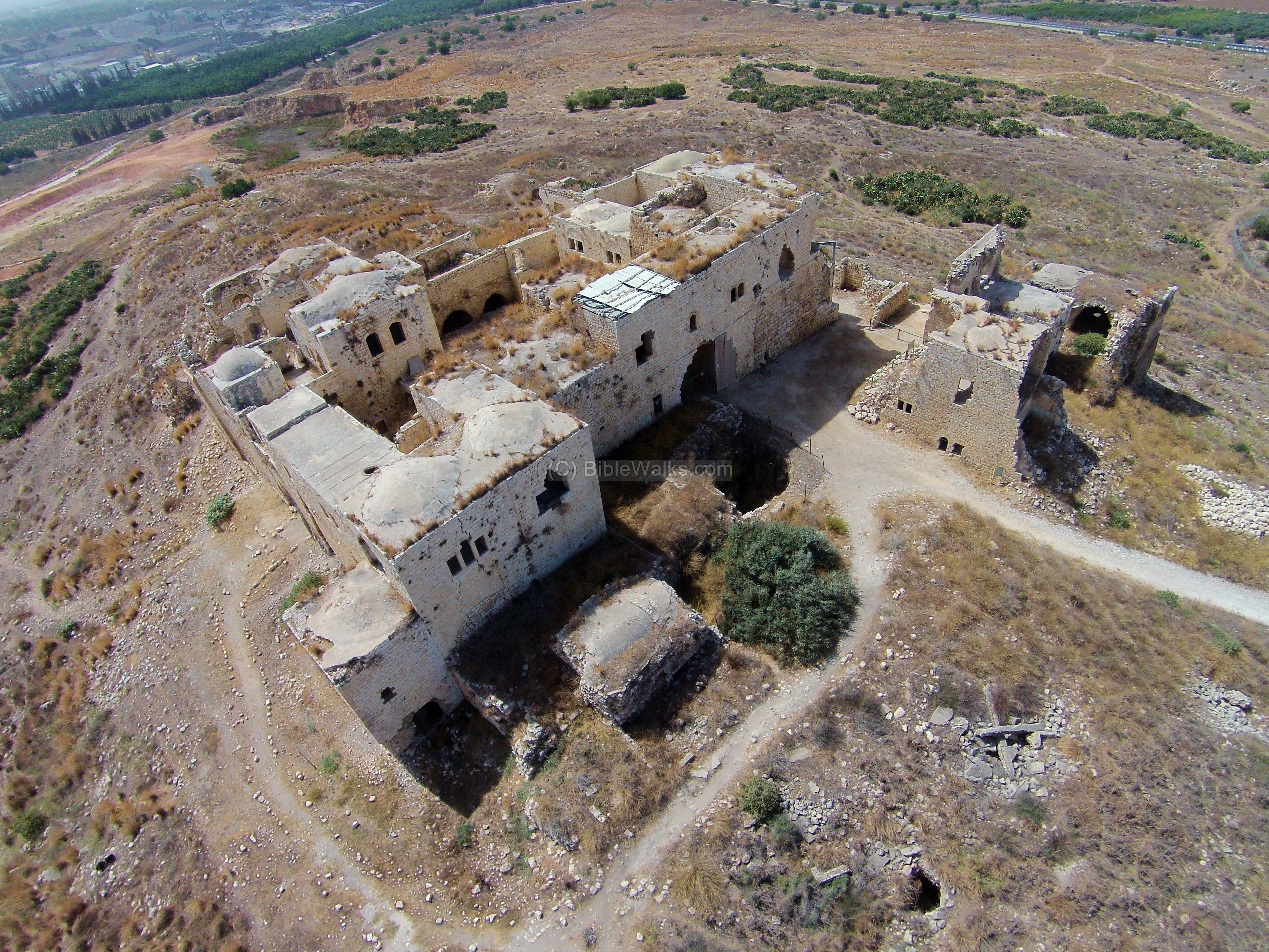
(b) Migdal Afek (Tsedek):
The fortress of Migdal Afek controlled the narrow pass of Via Maris. Most of the structures are dated to the 19th Century house of Sheikh Muhhamad Al-Sadiq, with some remains of the Crusader-period fortress (“Mirable”). An aerial view from the north side of the fortress was captured by a quad copter.
![]() Visit the site of Migdal Afek.
Visit the site of Migdal Afek.
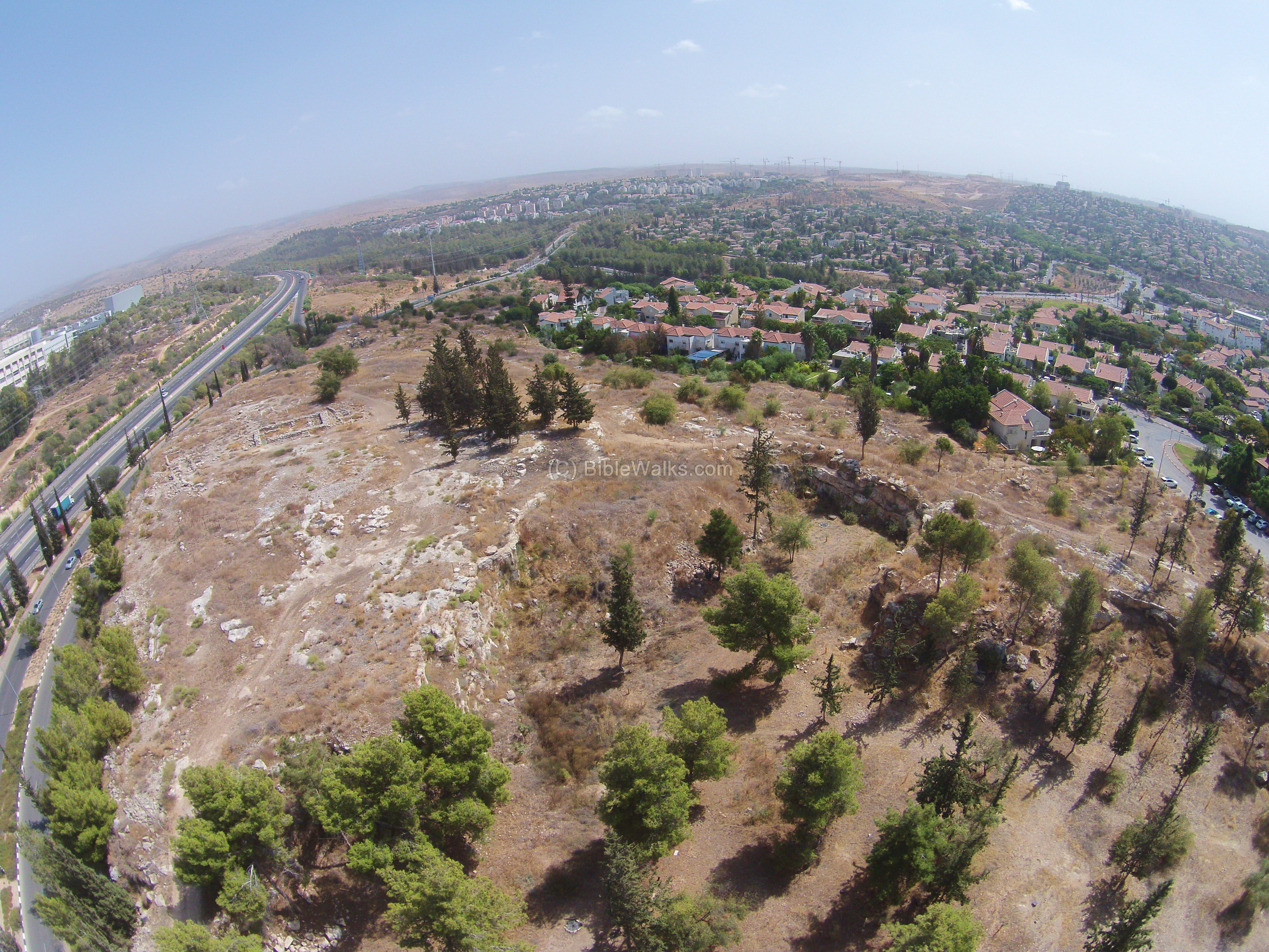
(c) Izbet Zartta
An Iron age agriculture settlement was excavated in Izbet Zartta, a small hill on the western hills of Samaria close to the ancient city of Aphek (Antipatris). It is identified as Ebenezer (“Stone of Help”), the place where the Israelites camped during their fatal battle with the Philistines.
1 Samuel 4 1: “Now Israel went out against the Philistines to battle, and pitched beside Ebenezer: and the Philistines pitched in Aphek”.
Izbet Zartta is located on a small hill which is accessible from the northern houses of Rosh HaAyin (“The head of the Spring”, seen in the background). This droneview shows the site from the west side, with traces of the ruins visible in the center of the hill. The quarry on the bottom right side cut into a section of the hill.
![]() Visit the site of Izbet Zartta
Visit the site of Izbet Zartta
Click on the photos to view in higher resolution…
(d) Horvat Te’ena
Ruins of a Byzantine monastery, situated on a hill on the south east side of the city of Rosh HaAyin. The site, Horvat Te’ena (חורבת תאנה, Khirbet Umm et Tina), was built during the period of Justinian I (527-565 AD), based on his coin found in the nave. The walled monastery consists of a basilica church, several rooms and courtyard, an oil press, a winepress, and stable.
- Archaeological Reference: Khirbet Umm et Tina Monastery
- Rosh Ha-‘Ayin (South and East) – Amit Shadman, Horvat Te’ena (pp. 12-18)
![]() The following 10 minutes video tour of the site was captured on June 2025:
The following 10 minutes video tour of the site was captured on June 2025:
(e) Iron Age II farmhouse
In the southern side of modern Rosh HaAyin lies a remarkably preserved Iron Age II farmhouse, dating to the 8th century BC. Excavated in 2015 by the Israel Antiquities Authority, the structure spans over 1,200 square meters, with a central courtyard, 23 rooms, and clear evidence of industrial agriculture. Winepresses, olive oil installations, and a large grain silo point to surplus production. The farmhouse was part of a settlement wave that began after the Assyrian conquest campaigns in the region. Continued use into the Persian and Hellenistic periods, including a coin of Alexander the Great, reflects the site’s long-term significance. *
- Archaeological Reference (Hebrew): Amit Shadman IES 2015
- Rosh Ha-‘Ayin (South and East) – Amit Shadman, Farmhouse 740 (pp. 2-6)
![]() The following 3.3 minutes video of our tour was captured on June 2025:
The following 3.3 minutes video of our tour was captured on June 2025:
(f) Khallat es-Sihrij: Ancient Farmstead with a Remarkable Water System
On the southern outskirts of Rosh HaAyin lies the archaeological site of Khallat es-Sihrij—Arabic for “the water reservoir.” This intriguing site was first established in the late 8th century BC, during the Assyrian period (Iron Age II), and remained in use through the Persian and Hellenistic periods. In the Ottoman era, a lime kiln was constructed on its southwestern edge, marking the site’s continued use into more recent history.
Covering a roughly square area of 45 by 45 meters, the compound includes a large central building surrounded by rooms, storage spaces, and a spacious open courtyard. The entire site was enclosed by four massive stone walls, each 1.5 meters thick and preserved up to a height of 2 meters. These walls were built with two rows of large stones and filled with smaller stones in between—a testament to the solid construction typical of the period.
The heart of the original settlement was a square building measuring 18 by 19 meters, constructed around a large underground water reservoir. This reservoir, dating to the late Iron Age, is an impressive engineering feat: 19 meters long, 4 meters high, and able to hold about 200 cubic meters of rainwater collected from runoff. Eight steps once led down into the reservoir from a now-blocked entrance.
One of the site’s most fascinating features is the set of engravings found on the plastered reservoir walls. These include human figures with outstretched arms—some seemingly holding objects—alongside crosses and plant motifs, likely carved during a later period. A vertical shaft on the eastern side of the reservoir allowed residents to draw water without descending the stairs.
In the 7th century BC, the site underwent a major expansion, growing into the full 45-by-45-meter compound. New areas were added to the north and east, with small rooms lining the southern and western sides. This expanded layout, centered around the large courtyard, reflects the site’s development into a substantial rural compound—possibly serving as a farmstead or roadside station along regional trade or travel routes.
Khallat es-Sihrij offers a remarkable glimpse into daily life in the ancient Land of Israel, combining solid architecture, clever water management, and hints of cultural expression carved into stone.
Archaeological Reference: https://www.hadashot-esi.org.il/Report_Detail_Eng.aspx?id=25726
![]() The following 5.5 minutes video captures a tour on June 2025:
The following 5.5 minutes video captures a tour on June 2025:
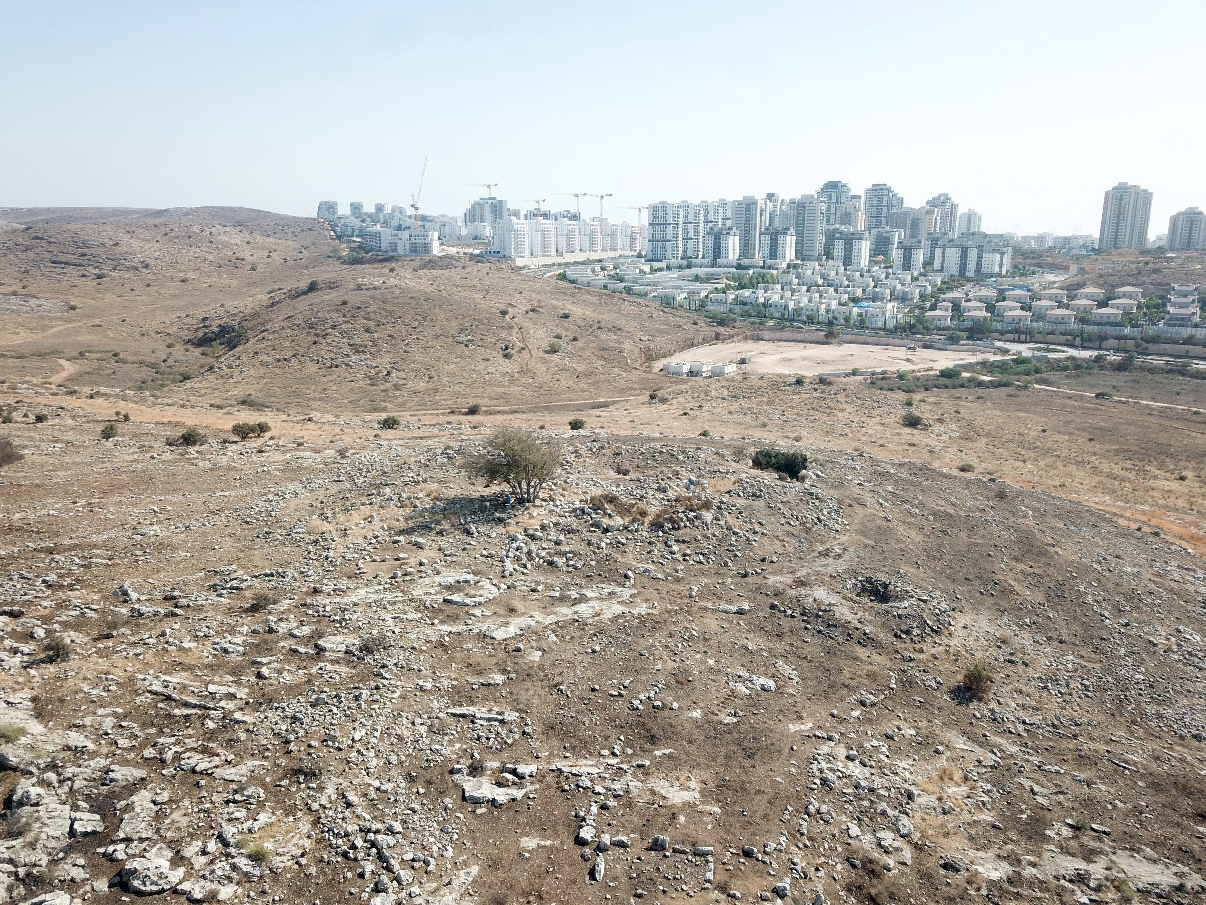
(g) Umm el Bureid (Horvat Barad)
Khirbet Umm el-Bureid (Horvat Barad) is a ruined site perched on a ridge east of Rosh HaAyin, overlooking the valley of Nahal Susi. Archaeological surveys found remains of a small Byzantine monastery. Within the complex are ruins of a church, domestic structures, an oil press, cisterns and large pool. Agricultural terraces are found around the site. On the western side is a round structure of a lime kiln. The site is situated near ancient trade routes that crossed Samaria through Nahal Susi and Nahal Rabah.
This photo was captured from the north side of the site. Nahal Susi flows from the east along the valley on the left side, then turns around the site and flows to the north joining Nahal Rabah (1km north of the site).
Observe the striking contrast between past and present—the Byzantine ruins beside Rosh HaAyin’s new southeastern neighborhood—where some 1,500 years separate the two phases of settlement.
![]() The following ~13 minutes video captures a tour on September 2025:
The following ~13 minutes video captures a tour on September 2025:
(h) Kh. Umm el Hammam
Khirbet Umm el Hammam (also Khirbet Hammam) is a ruined village, located 1km south east of Rosh HaAyin. Ruins of the extensive settlement are scattered on the western slope below the summit. The structures are built from dressed masonry—some with decorative drafting—and remain preserved up to three courses, with several entryways still standing. The site also contains essential infrastructure like cisterns and presses for wine and oil. Analysis of the pottery dates the occupation of this village, Khirbet Umm el Hammam, to the Byzantine and Early Arab periods.
Higher up, on the summit, are several standing structures. These buildings, dated to the Ottoman period, were built over the Byzantine period ruins, probably a Byzantine monastery. The main building on the summit is mostly intact.
Guerin visited the site and wrote about it in 1875 (150 years ago) before the current building was built over the ruins:
“On a neighboring hill, higher than that on which this ruin stands, I saw the remains of a little church built east and west, measuring 20 paces in length by 16 paces in breadth. Despite its small dimensions, it seems to have had three naves, and some fragments of columns lying on the ground are probably the remains of those which separated the central nave from the sides. The entrance was on the north by three rectangular doors, whose jambs supported monolith lintels. The buildings belonging to the church, and now destroyed, are probably those of a convent”.
References for this site: https://dig.corps-cmhl.huji.ac.il/rep_church_full/12725
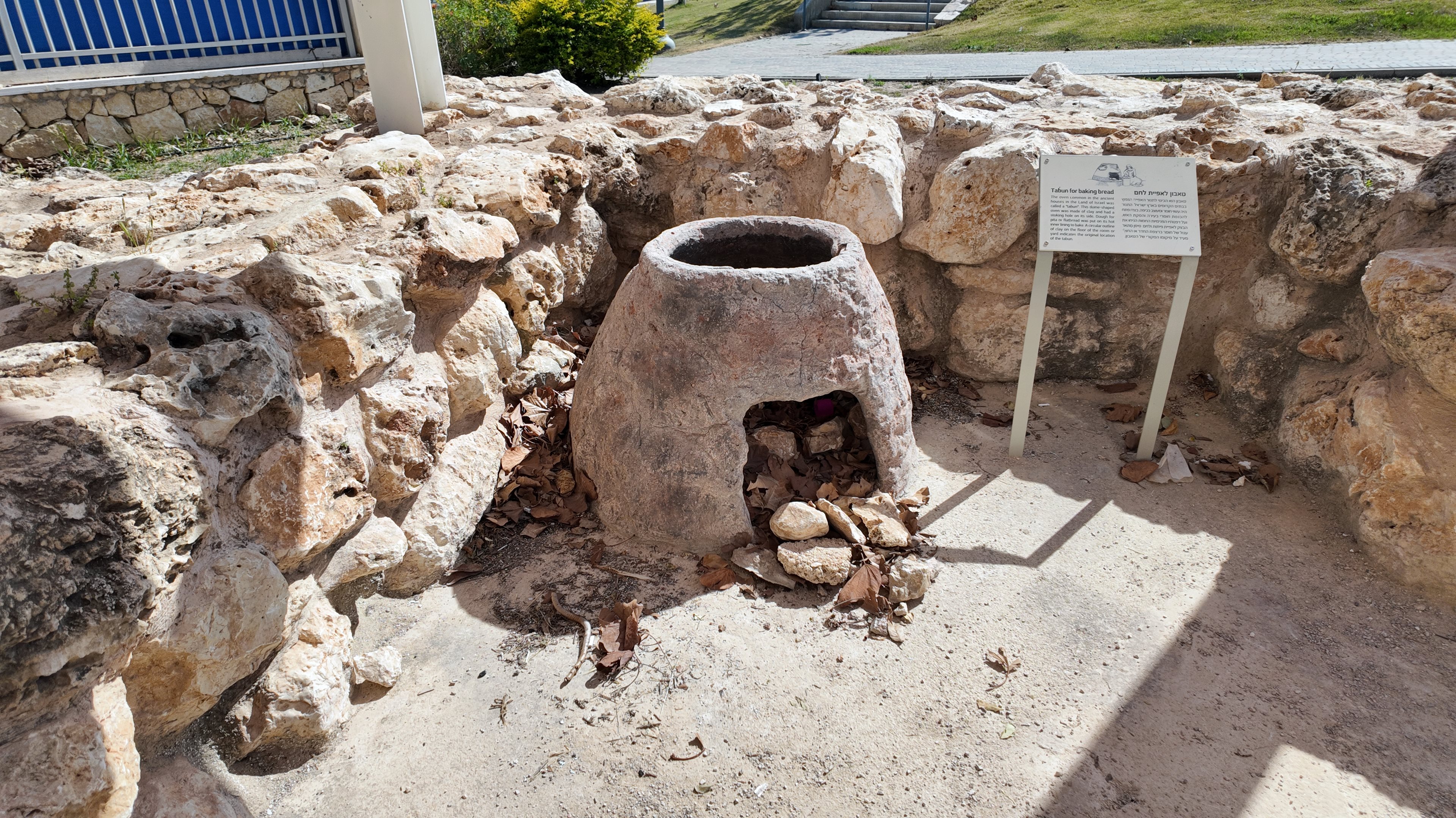
(i) “Nahal Shilo 3” farmhouse
An archaeological park was constructed on the southern edge of Prophet Eliyahu street, with a plan based on the “Nahal Shilo 3” farmhouse. This farmhouse was dated to the Iron Age II and Persian period, and was found near the crossing of Prophet Eliyahu and Prophetess Miriam streets. It was relocated here after the new neighborhood was built and is now open to the public for educational purposes.
The trapezoid shaped farmhouse was 21m by 20m in area, built over the bedrock and protected by a wall made of two rows of roughly cut fieldstones with smaller filler stones. There were 12 rooms on the eastern side of the farmhouse, and a large (12m x 18m) courtyard on the western side that was used as an animal pen.
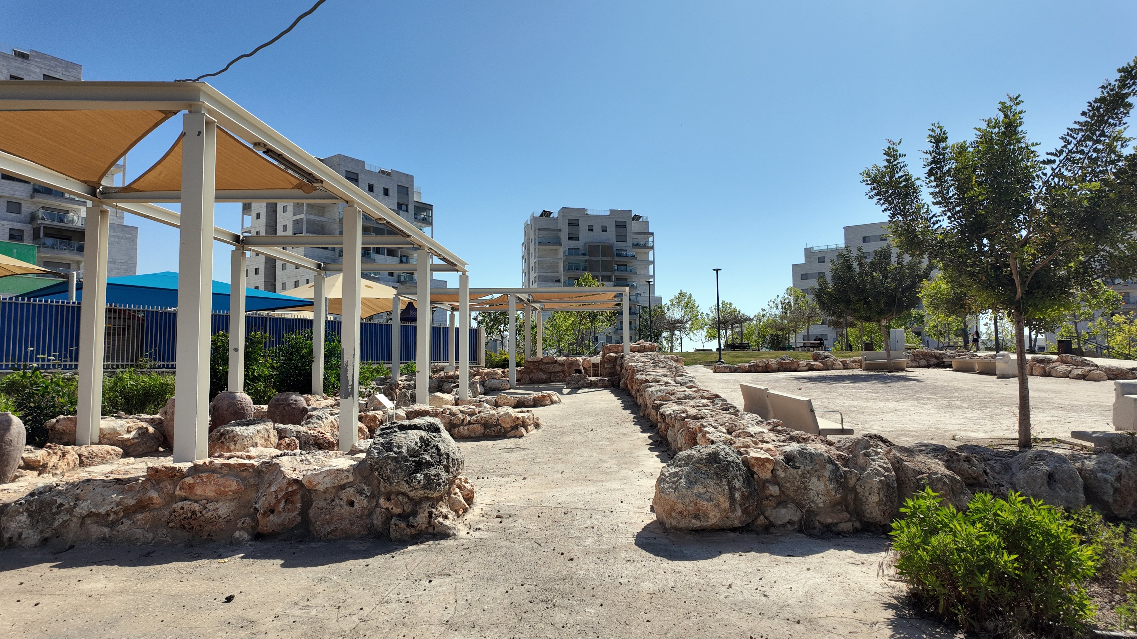
In one of the rooms is a display of clay vessels that were used to store grain, food and liquids.
The “Pithos” is a massive, thick-walled ceramic storage jar used throughout the ancient Mediterranean for storing bulk goods like olive oil, wine, and grain. Dating from the Neolithic to the Iron Age, these jars generally ranged from 0.5 to 2 meters in height and were frequently half-buried in the floor for stability and temperature control.
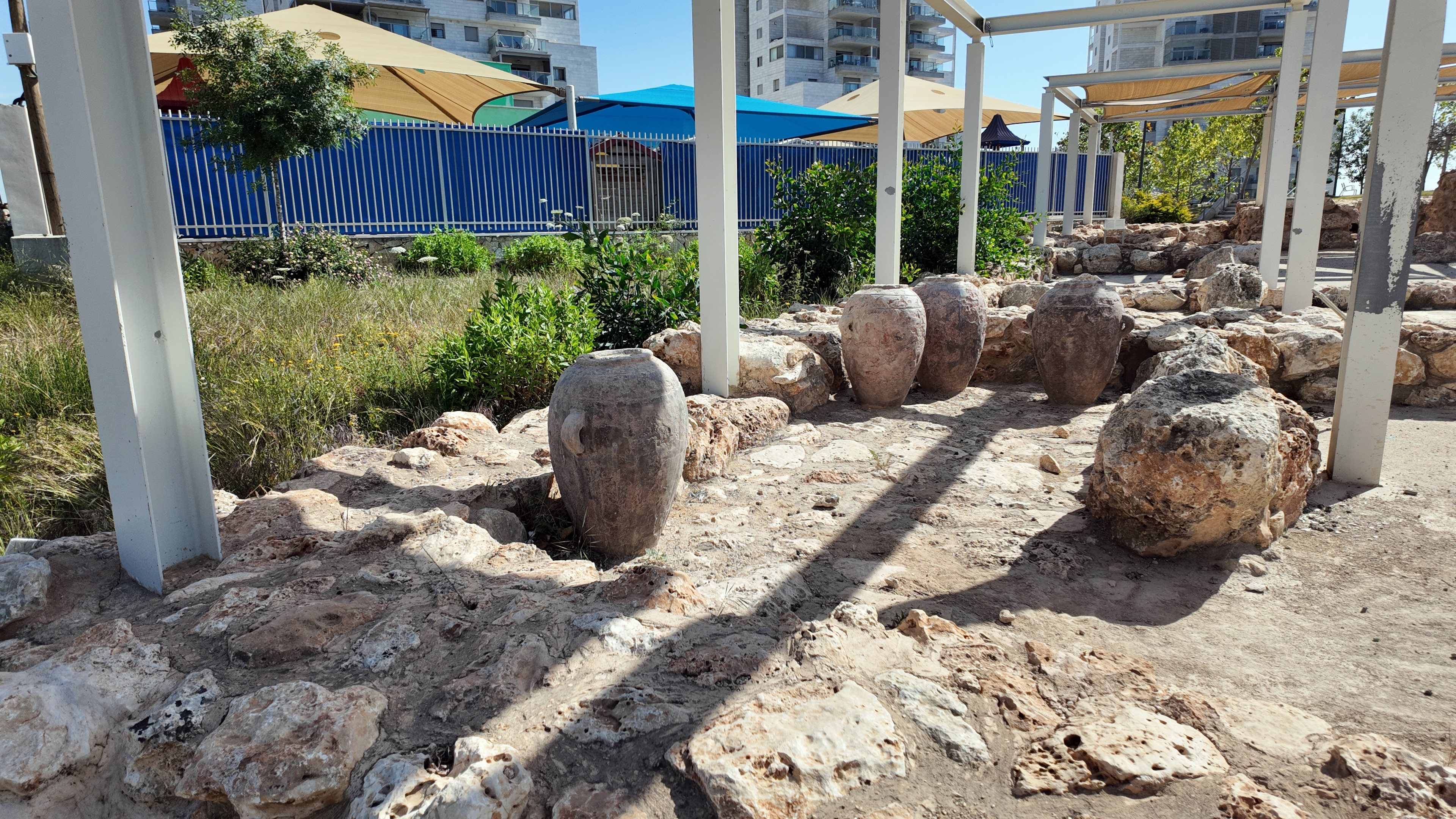
A “Tabun” is a dome-shaped oven made of clay that was used by the residents to prepare pita or bread. It is on display in the “kitchen” room. A stoking hole on the side of the oven was used to feed the fire, and also used to place the dough on its hot inner lining to bake.
The farmhouse was part of a settlement wave that began after the Assyrian conquest campaigns in the region, with continued use into the Persian period.
Reference for this site: Shadman 2015 (pp. 8-10). The excavator summarized: During the Iron Age II, a new settlement pattern was identified for the first time: farmhouses (measuring 1.0–1.5 dunams) constructed in the heart of open areas. Their construction was simple, typically following a square plan. Most of these farmhouses included courtyards and were situated near hewn cisterns. During this era, the Assyrian Empire exerted significant influence both within and beyond the Land of Israel, leading to various geopolitical shifts. It appears that the late 8th and early 7th centuries BC were characterized by a sense of relative security, which permitted habitation in small, unfortified farms rather than protected sites. These farmhouses continued to operate—and even flourished—during the Persian period, during which settlement distribution in the region reached its peak. Some of these farms remained active into the Hellenistic period as well.
(j) Qesem Prehistoric Cave
Qesem Cave represents a Middle Pleistocene archaeological site dated to approximately 420,000–200,000 years before present time. It is located on the north bank of Wady Rabah, on the side of highway 5 between Rosh HaAyin and Kfar Kassem. The site is not open to the public.
The site has yielded exceptional evidence for hominin behavioral evolution in the Levant, including systematic large-game hunting, recurrent use of fire, and the habitual production of flint blades using the Levallois and Amudian technologies. The spatial distribution of finds and hearths suggests organized activity areas, pointing to emerging patterns of social structure and subsistence strategy among late Lower Paleolithic populations.
Reference: https://www.jstor.org/stable/23383554
Etymology (behind the name):
* Names of the area:
- Ras el ‘Ain – Arabic name of the springs of Afek, meaning: Head of the Spring.
- Rosh HaAyin – Hebrew: “The head of the Spring”. A translation of the Arabic name of the spring. It refers to the headwaters of the Yarkon River, which emerge nearby from natural springs—particularly ‘Ayin Afek
- Afek (Aphek)- Hebrew for “stream” or “riverbed”. Refers to the area of the spring of ‘Ain Afek, where the main north-south ancient road had passed along a narrow passage. There are many Biblical references, such as : (1 Samuel 4:1) “Now Israel went out to battle against the Philistines… and they encamped beside Ebenezer, and the Philistines encamped in Aphek.”
- Migdal Afek, Migdal Afeq – Hebrew: Tower of Afek (Afek is a nearby city)
Links and References:
* External links:
- Hebrew stone quarries of Migdal Zedek – Dr. Avi Sasson
- Archaeological Survey of Israel
- Rosh Ha-‘Ayin (South and East) – Amit Shadman – summarizes four salvage excavations (years 2013–2015)
- Pottery shapes – a tutorial on pottery vessels
* Internal:
BibleWalks.com – Search for the lost cities of the Bible
Tel Esur <—previous site—<<<All Sites>>>—next Shefela site–>
This page was last updated on Apr 29, 2026 (add Nahal Shilo 3)
Sponsored links: