A walled Biblical city on a mound near the Jordan River. Nearby, a major prehistoric site with earliest remains of Early man outside Africa.
* Site of the Month – Jan 2016 *
Home > Sites > Jordan Valley> North > Ubeidiya (Ovadiah)
Contents:
Overview
Aerial Map
History
Photos
* Aerial views
* Mound
* Findings
* Village
* Mill
* Jordan river
* Nahum Bridge
* Prehistoric site
* Nature
* Survey
Links
Etymology
Background:
Ubeidiya is a major archaeological site located near the Jordan River, 3KM south west of the Sea of Galilee. On Tell Ubeidiya was a walled Biblical city, perhaps Beth Shemesh (“house of sun”) of the Galilee. Joshua 19:22: “And the coast reacheth to … Bethshemesh; and the outgoings of their border were at Jordan…”. On the summit are ruins of an Ottoman period village that was built over the Biblical cities.
The Bronze/Iron age periods city guarded the river crossing and the major roads that passed at the site. Remains of Early Man were identified west of the mound, and are one of the earliest settlements of Homo Erectus (an early Human specie) outside of Africa.
Map / Aerial View:
An aerial map is shown here, indicating the major points of interest around the site. The mound is located at a height of -201m, about 30m above the Jordan river. The minus sign indicates under sea level, as it is in the great Jordan valley Syro-African depression – the lowest place on Earth. The mound is adjacent to the Jordan river which flows, from north to south, on its east and south sides. The slow flowing shallow river created an “island” on the south side and also on the east side near Kibbutz Beit Zera.
The famous prehistoric site of Ubeidiya, a national park, is located nearby on the west side.

History:
-
Prehistoric periods – Early Man
The prehistoric site of Ubeidiya is located 200m west of the mound of Tell Ubeidiya, on the banks of Nahal Yavne’el. The excavations identified 150 layers, Homo Erectus bones, mammal bones (120 types) and more than 10,000 ancient tools. Use of fire was not identified at the site. The findings, starting from 1.4 Million years ago (Ma), is the earliest site of Homo Erectus found outside Africa. The geology of this area also changed considerably since the early settlement, as the ground level inclined by 70 degrees due to the tectonic and climate shifts, and an ancient lake once bordered the site. A national park was opened to the public in 2024 on a section of the prehistoric site.
The evolution of the modern human specie has some notable milestones:
One of the important events is the split of the Hominines (pre human subfamily) to a human branch and to chimpanzee branch, which occurred at about 4 Million years ago. The oldest form of human man (named Australopithecus) had evolved by the Early (Lower) Pleistocene period, spanning 2.588 to 0.781 Million years ago. The archaeologists classify the cultures at this time as Paleolithic (meaning: old stone age).
Homo Erectus (“Upright Man”) evolved in Africa at 1.8 Million years ago (Ma). This early human specie is similar to modern humans, but with 74% of the modern human brain size. They controlled fire by about 1.5 Ma and work stone tools such as hand axes, cutting tools and choppers. This specie lived more than a million years and was the first to live in a hunter-gather society.
Homo Sapiens (our species) evolved in Africa in about 250,000 years ago (0.25 Ma). They moved through the Levant to Europe only at about 120,000-100,000 (0.12-0.10 Ma) years ago. The cave of Gedi (es-Skul) on Mount Carmel has remains of that period. In the Middle Paleolithic period (80,000-40,000 years ago) they knew how to make knives, scrapers and points out of flint. They coincided with another specie – Neanderthal (a specie that eventually disappeared about 30,000 years ago). Another site with remains of this period was on Mt Precipice near Nazareth.
Few out-of-Africa early Hominine sites were found to date, such as Ubeidiya-Israel (1.6-1.2 Ma) and Dmanisi-Georgia (1.7-1.9 Ma remains). Therefore, this rare site was a major research of archaeology, history, geology, faunal (animals) and environment studies. The site is a key to understand the exact time this early man migrated from Africa to Europe.
-
Biblical periods (Bronze and Iron age)
On Tell Ubeidiya was a walled Biblical city, located on a high mound east of the prehistoric site. It was populated during the Bronze and Iron age periods.
The city had a natural defense: the Jordan river surrounded parts (or all sides?) of the mound. The strategic location on one of the main thoroughfares of the ancient times, made this city strong and wealthy. Some clerics regarded this area as “the garden of Eden”. The place is indeed blessed with abundant supply of water, good soil, and sun most of the year.
Beth Shemesh? A scholar, Pinhas Neeman, identified the city as Beth Shemesh (“House of Sun”) of the Galilee (Joshua 19:17,22):
“And the fourth lot came out to Issachar…And the coast reacheth to Tabor, and Shahazimah, and Bethshemesh; and the outgoings of their border were at Jordan: sixteen cities with their villages”.
The “House of Sun” is a name of other Biblical places, such as Beit Shemesh in the south. The Canaanite city may have been named Ir-Shemesh (“Sun City”) as its people may have worshipped the sun. Another Canaanite city 3 KM to the north worshipped the moon (Beit Yerach), as did Jericho (their names are based on the Hebrew word “Yerach” meaning ‘moon’).
The practice of sun worship was common in ancient times, and the Bible warns against it (Deuteronomy 4 19): “And lest thou lift up thine eyes unto heaven, and when thou seest the sun, and the moon, and the stars, even all the host of heaven, shouldest be driven to worship them, and serve them, which the LORD thy God hath divided unto all nations under the whole heaven”. There were several cities named after the sun or the moon, and the practice was common even later during the period of the Israelite Kingdom (2 Kings 23 5): “And he put down the idolatrous priests, whom the kings of Judah had ordained to burn incense in the high places in the cities of Judah, and in the places round about Jerusalem; them also that burned incense unto Baal, to the sun, and to the moon, and to the planets, and to all the host of heaven”.
The cities and roads during the ancient periods, up to the Roman period, are indicated on the Biblical Map below. The site, marked as “Beth-Shemesh”, is on the path of a major south/north ancient road, depicted as a grey dashed line south of the Sea of Galilee and west of the river (a blue line flowing down).
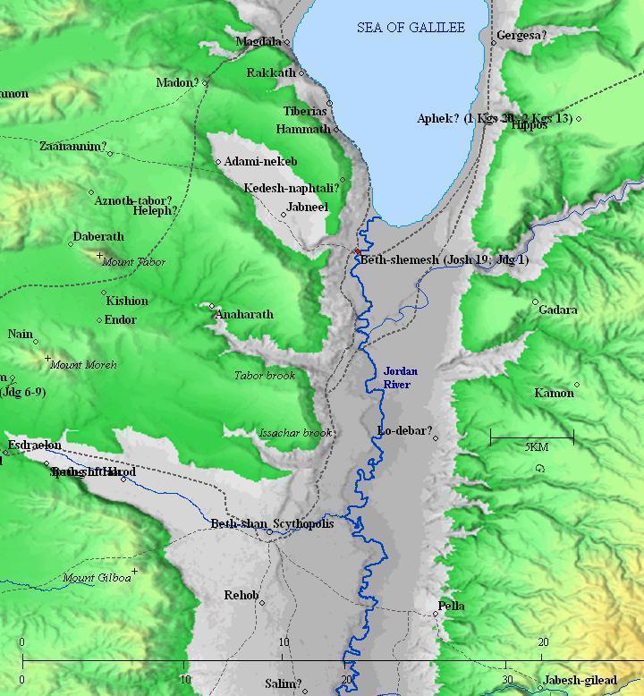
Map of the area around Ubeidiya, marked as Beth-Shemesh,
from the Canaanite/ Israelite periods to the Roman period (based on Bible Mapper 3.0)
- Ancient Highways:
According to David Dorsey (“The Roads and Highways of Ancient Israel”, pp. 105-107) the site was located at the side of important Bronze/Iron roads and highways. The following roads passed thru Tel Ubeidiya:
- ‘T1’ highway – Acco–Hannathon–Tel Adami-Yavneel – Tell Ubeidiya road (Darb el Hawarna)
- ‘T2’ road – Mt Tabor – Tel en Hadda – Tell Ubeidiya
- ‘A3’ highway- Hammath – Rehob – Beit Shean – Tell Ubeidiya
The site was also guarded two Jordan river crossing places – Umm Juni and Umm el Maza.
-
Hellenistic/Roman/Byzantine Period – (3rd century BC – 7th century AD)
Remains of a section of the Roman road from Beit Shean to Tiberias were found on a trial excavation on the western side of the mound, about 200m from the Jordan river, on the side of a agriculture road. Findings also included Hellenistic and Roman period coins and pottery shreds.
A detail of the Peutinger map (Peutingeriana tabula), based on a 4th century map of Imperial Roman roads, is below. It is oriented with the top side as the west. The map shows the major military roads between Jericho (on the middle left, named here by its Roman name – “Herichonte”), though Beit Shean (“Scytopoli”) to Tiberias ( “Tyberias”) above the icon of the Sea of Galilee. The distances are marked with Latin numbers, being XXIII (which means 23 Roman miles, or 35KM, between Beit Shean and Tiberias).
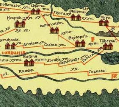
Section of the 4th Century Peutinger Map, focusing on the Jericho-Beit Shean-Tiberias road
-
Ottoman Period – (1516-1918 A.D.)
During the late Ottoman period a small village (El ‘Abeidiyeh) was located on and around the hill.
The area was examined in the Palestine Exploration Foundation (PEF) survey (1866-1877) by Wilson, Conder and Kitchener. This map is part of sheet 6 of their survey results. Their description of the site is on page 360 of Volume I:
“El ‘Abeidiyeh – Stone and mud houses, built on a round tell, close to the Jordan river. It contains about 200 Moslems, and the plain is cultivated. There are several mills in the neighborhood. There are a few small palms, but not many trees, round the village”.
The Arab village of El ‘Abeidiyeh was inhabited by former slaves from Africa, which was the basis of its name (the village of slaves). This was explained in the PEF dictionary (names list of sheet VI, p. 121): “El ‘Abeidyeh. from ‘Obeid’, ‘a little slave’ (but perhaps connected with the Biblical name Obadiah). The village was deserted in 1948, and the only visible remains is a wall of the old mill.

Part of map sheet 6 of Survey of Western Palestine, by Conder and Kitchener, 1872-1877.
(Published 1880, reprinted by LifeintheHolyLand.com)
River crossings: Another point of interest is the village of Umm Junieh (p. 362), where a Jordan river crossing (“Makhadet Umm Junieh”) was located at that village. “Umm Junieh: A stone and mud village on the east side of the Jordan, on the top of the eastern bank of the river ; contains about 250 Muslims. The plain round is arable soil : no trees. A mill is worked at the village”. Degania was later established at that site (1909) and became the first Kibbutz (communal settlement) in Israel.
Another river crossing was south of Ubeidiya – at Makhadet Umm el Maza.
- British Mandate
A section of the 1940s British map shows the area around the Arab village El ‘Ubeidiya.
The site is situated at the mouth of Jabneel stream (Wadi el Fajjas) that flows to the Jordan river. Notice the aqueduct canal that conveys waters from the springs along the Yavneel stream to the village and the mills, marked by a solid line. The cemetery of the village (“Cem”) is on the west side. The north-south road passes the village on its west side. It crosses the river via a ford (Makhadet Umm el Maza) south of the site.
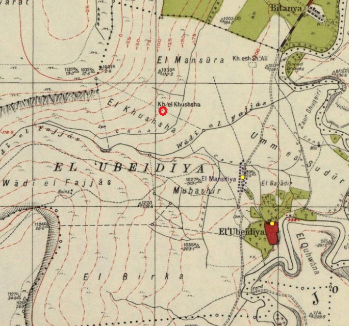
British survey map 1942-1948 – https://palopenmaps.org topo maps
License: public domain under the UK Copyright, Designs and Patent Act 1998
-
Modern period
The modern Hebrew name of the site is “Tel Ovadia”, meaning the mound of Obadiah (a Biblical prophet during the times of King Ahab).
- Prehistoric site:
The prehistoric site was discovered “by chance” in 1959, when surface finds of stone tools and bones were found near the mound. They were initially dated to the Early (Lower) Pleistocene period. This exciting find started a series of extensive archaeological excavations at and around the site, spanning 40 years. Excavations were conducted in 1960-1966 (headed by M. Stekelis), 1967-1974 (O. Bar-Yosef and E. Tchernov), 1988-1994 (E. Tchernov and C. Guerin), 1997-1999 (J.J. Shea, G. Bozinski and O. Bar-Yosef ). Excavations at the prehistoric site exposed material culture from the Early Paleolithic period, starting at 1.4 Million years ago. The prehistoric site was opened to the public in 2024.
Excavations on the mound revealed remains from the following periods: Early and Late Bronze, Iron, Persian, Roman, Byzantine, Early Islamic, Crusader, Mameluke and Ottoman.
The site is in an open public area (National Park), and is easily accessed by road from Beit Zera, a Kibbutz founded in 1927. The picturesque place, on the banks of the slow flowing Jordan and surrounded by palm trees, is indeed a “garden of Eden”.
Photos:
(a) Aerial Views
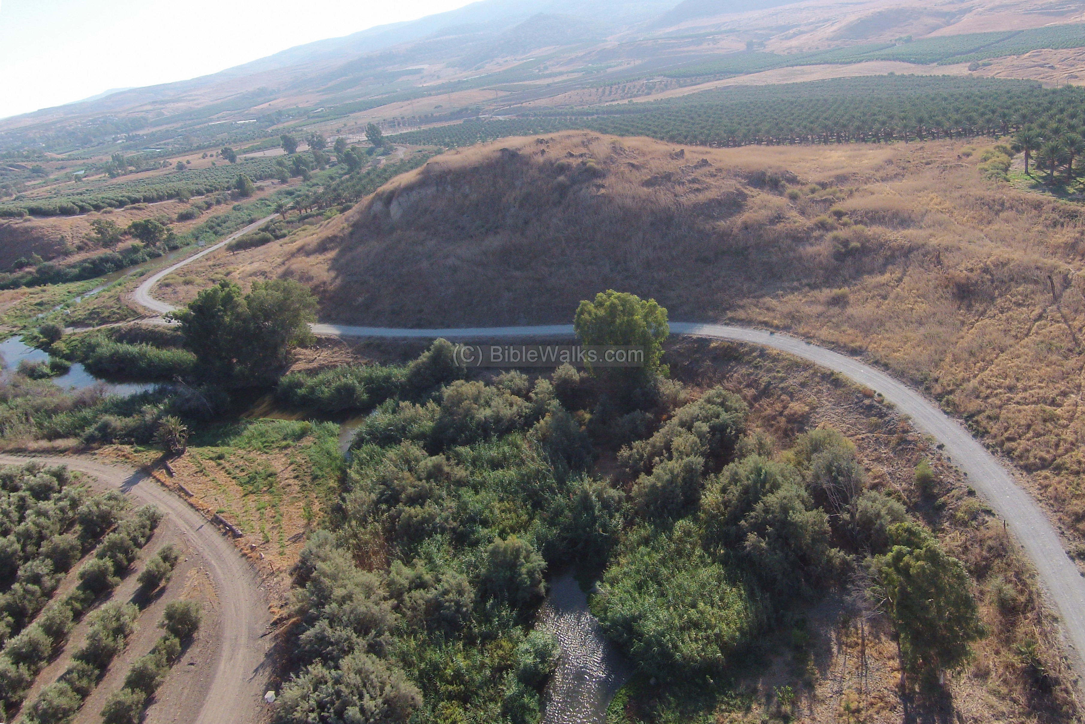
A view of Tel Ubeidiya was captured from the south side by a drone. The Jordan river loops around the east and south sides of the mound. The prehistoric site is seen to the far left (west) of the hill.
Click on the photos to view in higher resolution…
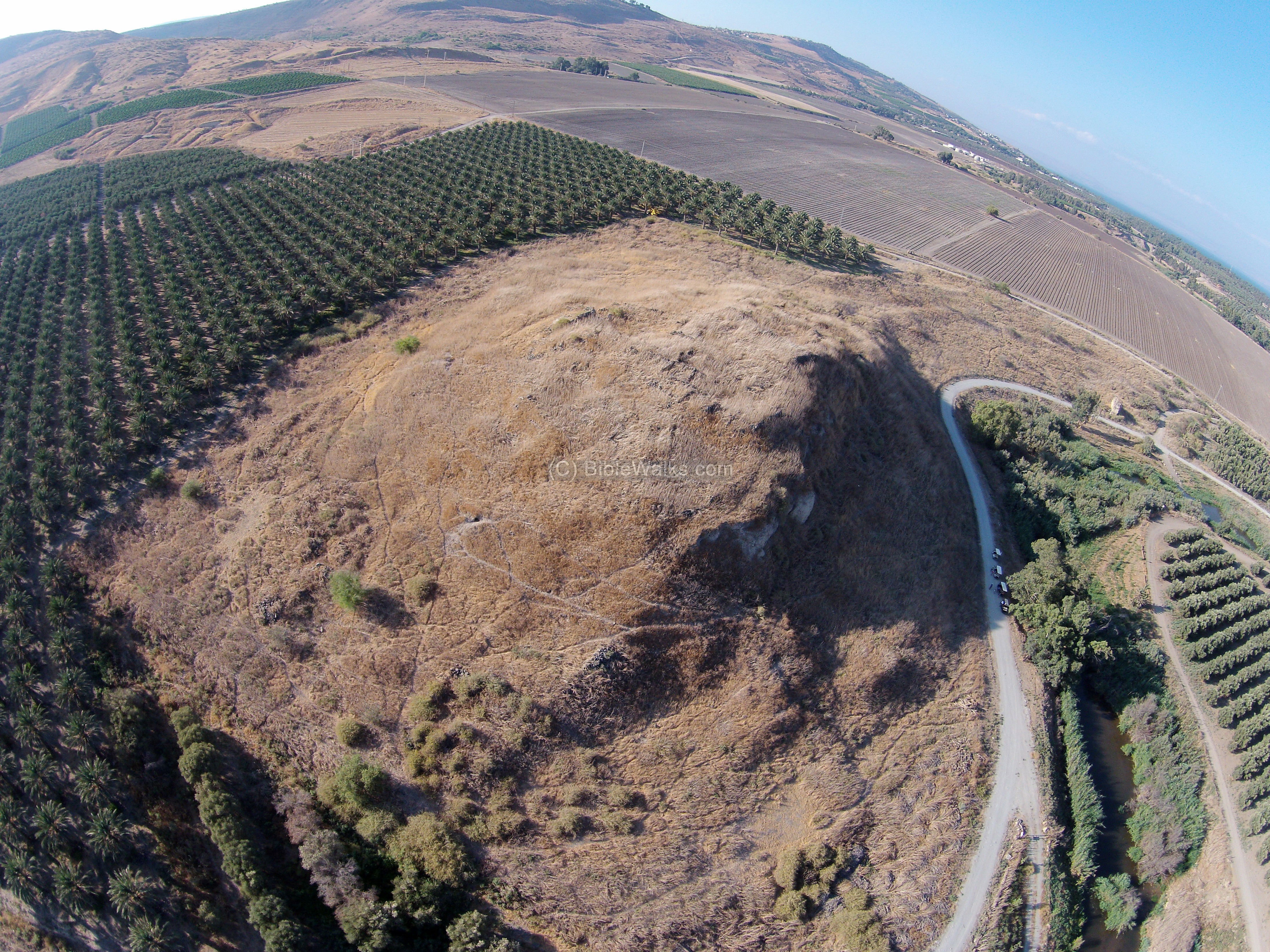
Captured on Oct 2015
Another view, from the north east side, is seen in the following photo:
Another view, from the south side, is seen in the following photo.

![]() Fly on the south and north sides of the site with this new YouTube video (captured Dec 2024):
Fly on the south and north sides of the site with this new YouTube video (captured Dec 2024):
(b) The Biblical city
Remains of the Biblical city are located on top and around the mound. It is seen here from the north east side, above the west bank of the Jordan river.

The east side of the mound is cut, revealing the composition of its soil.

A closer view to this section was captured during our survey of December 2024, when we examined the pottery sherds on this side of the mound.

(c) Findings
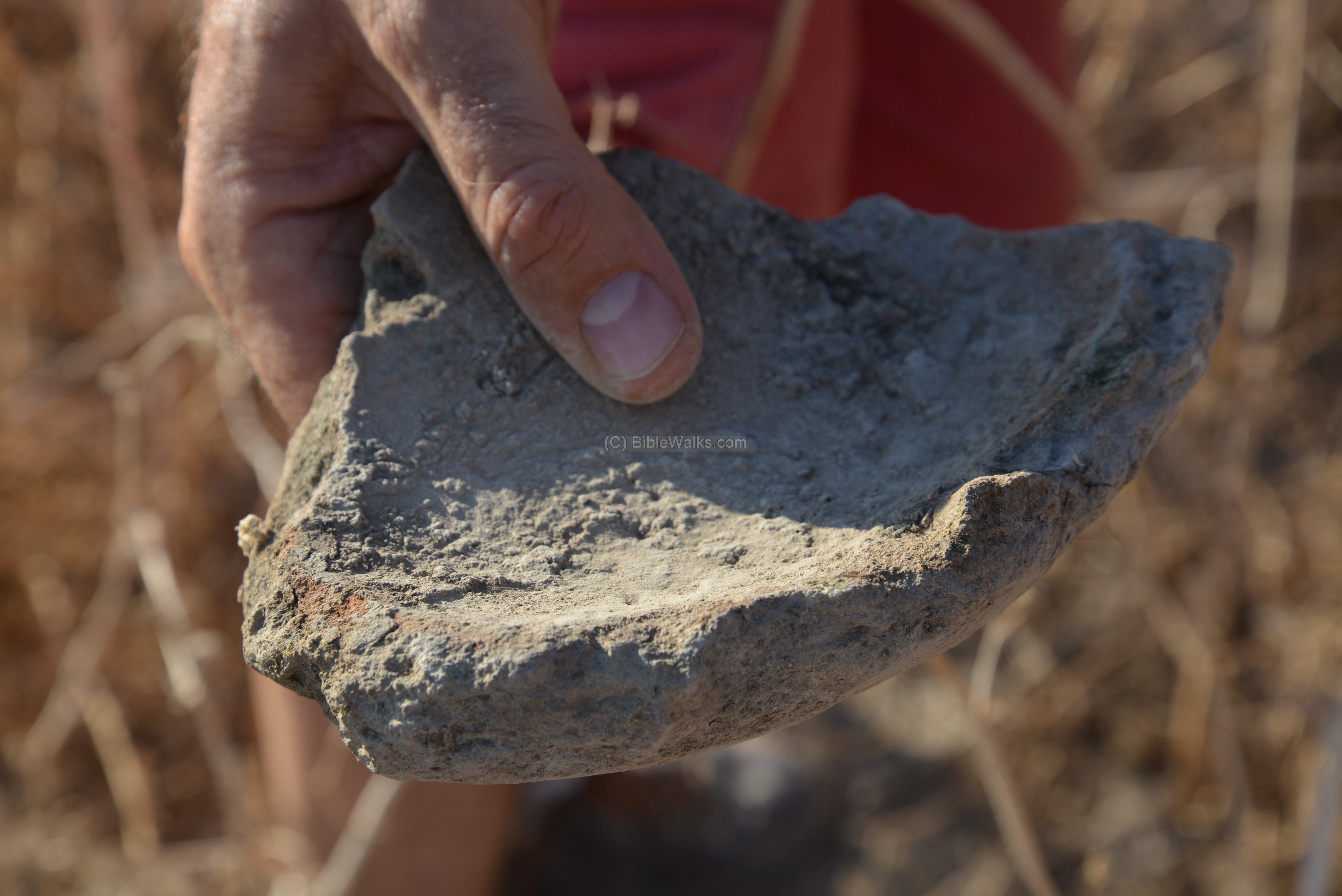
- Basalt tools
During our first visit during summer, the hill was covered with dry brushes, making it difficult to see what lies on the ground. However, we could notice a fragment of a man made basalt stone bowl.

We also observed a fragment of a large (30cm diameter) and thick (2.8cm) ceramic bowl.
- Pottery
Excavations on the mound revealed remains from the following periods: Early and Late Bronze, Iron, Persian, Roman, Byzantine, Early Islamic, Crusader, Mameluke and Ottoman.
During our next survey of December 2024, we found interesting sherds. On the foothills are deep holes that were dug in by porcupines. The mammals dig into the ground, pulling out dirt and pottery fragments, making it easy to sift thru the soil and pick up the ceramics. Here are some samples (all items were left on the site).
From the first hole was a collection of pottery vessels, sherds and bones. We assume that this was a burial place, judging on the bones and the complete vessels.

A closer view of some of these vessels;
A small jug, dated Middle Bronze II.

Another small jug, also dated Middle Bronze II.

On other places on the eastern side of the hill, we found more sherds.
Iron II cooking pot:

Late Bronze decorated vessel, painted over with red lines:

A base of a vessel, Middle Bronze:

We also found sun-dried mud bricks. During the antiquities these mud bricks were used to build high walls and structures. Most of them crumbled over the years, but some survived especially if they were caught on fire during a conquest such as this brick.

(d) Ottoman period village
During the late Ottoman period (19th-20th Century) a stone and mud village was located on and around the mound. The village’s residents were former African slaves, which is the source of the name of the village (Ubeidiya in Arabic means village of little slaves).
On the summit are remains of dozens of structures of the Muslim village.

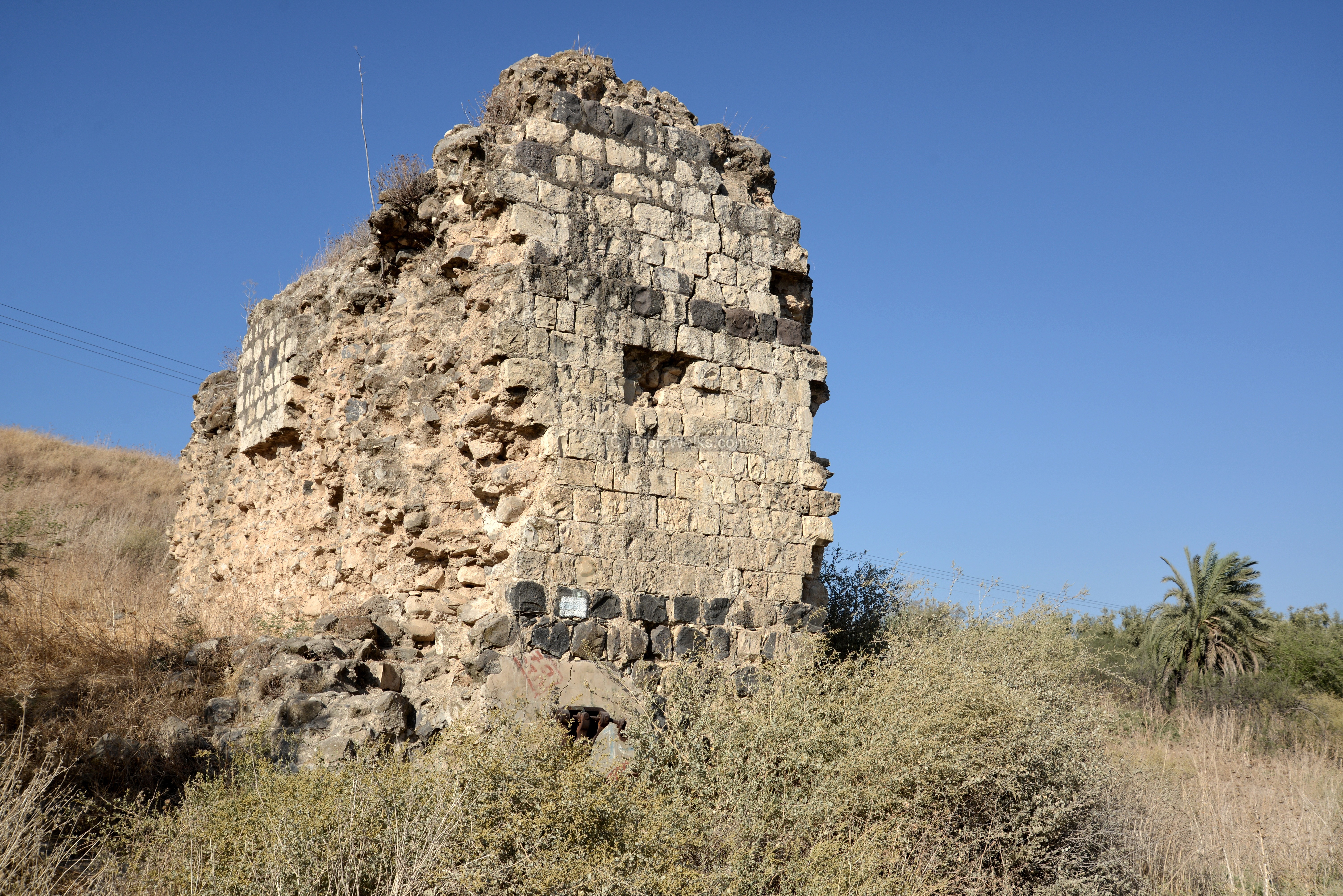
(e) Mill:
Another noticeable remain is this wall, remains of an Ottoman period water mill standing north of the mound.

Another view of the wall of the mill, one of several mills that once were built in the area:
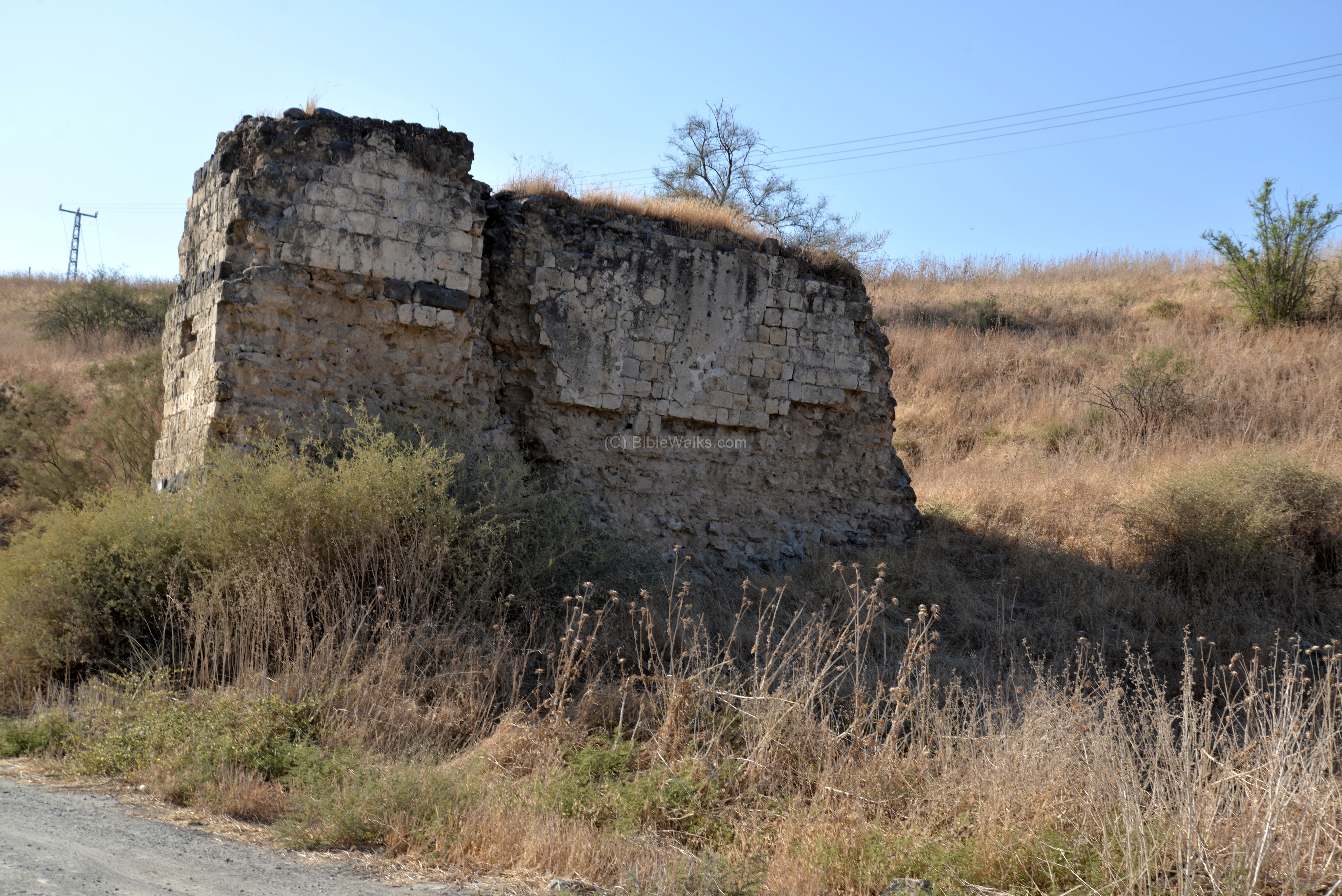
This flour mill operated on the power of water. The water was fetched from the Yavne’el stream via an aqueduct, and due to the altitude differences the force of the falling waters turned wheels that crushed the grains into flour.
(f) Jordan River
The shallow and slow flowing river passes at the eastern foothills of the mound. Above on the edge of the cliff is a memorial observatory place named after the late Mussa (Moshe) Lahav, a farmer of Beit Zera. A great place to relax and take pictures of the “island” of Ubeidiya, created by a changing course of the river.
The waters look welcoming…
Although the Jordan is regarded as a river, here it is a narrow stream. The outlet from the Sea of Galilee was blocked in modern times in order to supply water to the south of Israel and to the nearby state of Jordan, which minimized the flow down the Jordan valley.
A convoy of a dozen off-road vehicles passed near the mound. You can join such tours by contacting the company (“Bashvillim”) who organize tours on 4×4 vehicles along the river.

(g) Nahum Bridge
The Nahum memorial bridge is located closer to the Kibbutz. It was reconstructed in 2014-2015, as part of the Jordan valley rehabilitation project, on the site of the old wooden bridge. The sign records the event in January 12, 1949, when the Degania dam on the south side of the Sea of Galilee blocked the flow of the Jordan river. Then, the members of Kibbutz Beit Zera, lead by Nahum Sela, built within that day a bridge over the river in order to let the livestock to cross the river to the west side.
(h) Prehistoric Ubeidiya
The prehistoric site of Ubeidiya is located 200m west of the mound of Tell Ubeidiya, on the banks of Nahal Yavne’el. This is a view of the prehistoric site, as seen from the summit of Tell Ubeidiya.

A national park was opened to the public in 2024 on a section of the prehistoric site. Visitors can walk down along a trail to a section of a wall where the excavated layers can be seen.
The excavators revealed 150 geological layers spanning 1.6 to 1.2 million years ago.
A new study suggested an earlier date of 1.9 million years ago, significantly older than previously thought.
Due to the tectonic activities of the Syrian-African rift along the Jordan river, the layers with the human stone tools and animal bones are now seen nearly vertical rather than horizontal.
This steep inclination of the layers can be viewed from the side, as seen in the following photo. The thick white layer on the left side was the bottom a sea, accumulating deposits for millions of years. After the sea retreated, several layers of human and animal activities accumulated on it over hundreds of thousands of years, as seen in the central layer. Finally, a several top layers deposited soil and stones above it, as seen on the right most layer.

In the central layer were numerous faunal remains: hippo, deer, bear, tiger, antelopes and other species that lived here.
As for human activities, lithic and bone remains were found in 80 layers. Few Human skeletal remains were uncovered. Human made tools, made of flint, basalt and limestone, consisted of chopping, scraping and cutting tools, and were used to assist the early man in various daily activities. These tools were shaped as trihedral (having three edges or faces meeting at a central point, forming a triangular shape) and Spheroid (having a rounded or ball-like shape).
The recent discovery is that the site is significantly older than previously thought—dating back at least 1.9 million years, rather than the 1.5 million years previously estimated. This places ‘Ubeidiya on par with the Dmanisi site in Georgia as the oldest evidence of early humans (hominins) outside of Africa. The study pushes back the evidence of early human presence in the Levant by hundreds of thousands of years. It suggests that the migration out of Africa occurred much earlier and more complexly than once believed.
Researchers used a combination of three sophisticated dating methods to arrive at this new timeline: (a) Cosmogenic Isotope Burial Dating: This acts as a “geological clock,” measuring rare isotopes that form when cosmic rays hit rocks. Once the rocks are buried, these isotopes decay at a known rate. (b) Uranium–Lead Dating: Performed on fossilized Melanopsis (freshwater snail) shells found in the sediment to establish a minimum age for the layers containing stone tools. (c) Imaging Techniques: Used to reveal mineral layers preserved within the shells..
(i) Nature
We bring here two local types of trees in juxtaposition – a blessed tall tree that provides food and shelter (the date palm tree), and on the other hand a loathed low and underground “tree” (the Dwarf Mesquite).
Date palms are one of the main sources of agriculture income of the settlements of the Jordan valley. Large areas are planted with the palm trees. The Bible has numerous praising references to this blessed tree, such as (Psalms 92 12): “The righteous shall flourish like the palm tree”

The next photo shows a thorn with dark fruits, which look like beetles. It is is one of the typical low bushes here. It is called “Dwarf Mesquite” (Prosopis farcta). In Hebrew it is called “Yanbut Hasadeh“, based on the Arabic name, as the plant drills down into the ground. This is actually an underground tree, with thick deep roots reaching ~8m and thin roots reaching up to ~25m. The leaves above the ground are up to 0.3m, hence the prefix “dwarf”. It loves sun and enjoys the dry valleys, and in the summer it has small yellow flowers. It is almost impossible to get rid of, so farmers and homeowners loath this stubborn bush.
A Biblical reference can be found in Isaiah 7:19: “And they shall come, and shall rest all of them in the desolate valleys, and in the holes of the rocks, and upon all thorns, and upon all bushes”.
Thanks to Chris Shive for the identification
(j) Site survey
On December 2024 BibleWalks team surveyed Tell Ubeidiya and recorded the survey. This video is 18+ minutes long, features an inspection of the site, pottery dating, and drone capture of the mound.
Links:
* External links:
-
Community structure through time – Miriam Belmaker, Hebrew Univ. Thesis (2006, pdf 304 pages)
- Ubeidiya an early paleolithic site in Israel – Christopher Thomson (lecture, 2013)
- Ubeidiya Site was redated to 1.9 million years ago (2026, Hebrew)
-
Hadashot Arkheologiot Volume 126 (2014)
-
Bashvillim – trailwise – history on wheels
-
Yahweh and the Sun – Biblical and Archaeological evidence for sun worship in Ancient Israel – J. Glen Taylor [JSOT press 1993, ISBN 1-85075-272-9, 321 pages]
* Internal Links:
- Tell Ubeidiya site survey (18+ minutes video)
- Drone Aerial views – collection of Biblical sites from the air
- Trees of the Holy Land – sample trees in our website
- Prehistoric sites in Israel – overview and sample sites of prehistoric sites
- Prehistoric Tools – info page on early man tools
Etymology – behind the name:
* Names of the site:
The PEF survey dictionary (p.121) suggests two possible sources for the name of Ubeidiyah:
- El ‘Abeidyeh. Arabic, from ‘Obeid’, ‘a little slave’ (the Arab village was inhabited by slaves from Africa)
- Tell Ovadya, Ovadiah, Obadiah – Hebrew for “servant of God”. A prophet in the 8th Century BC (Obadiah 1:1): “The vision of Obadiah. Thus saith the Lord GOD concerning Edom; We have heard a rumour from the LORD, and an ambassador is sent among the heathen, Arise ye, and let us rise up against her in battle”. The prophet served Ahab (1 Kings 18: 3-7): “And Ahab called Obadiah, which was the governor of his house….”.
![]()
BibleWalks.com – walks along the Jordan river
Belvoir<<<—previous Jordan valley site—<<<All Sites>>>—next site—>>> Tel Nissa
This page was last updated on Feb 24, 2026 (new dating)
Sponsored Links: