Located on the western shore of the sea of Galilee, this city is one of the Holiest Jewish cities for 2000 years.
Home > Sites > Sea of Galilee> Tiberias (Overview)
Contents:
Background
Location
History
Photos
* General view
* South East
* Hotels & Tourism
* Archaeological park
* Citadel and Seraya
* Roman/Byzantine City
** Berniki Hill
** South Gate
** Theater
** City Bathhouse
** Basilica
** Miriam’s Well
Biblical Refs
Historical Refs
Etymology
Links
Background:
Tiberias is a city in northern Israel, located on the western shore of the Sea of Galilee (also known as Lake Kinneret). It is named after the Roman Emperor Tiberius and was founded in the first century CE, making it one of the oldest cities in the region.
Tiberias has a rich history and was an important center of Jewish scholarship and culture during the Roman and Byzantine periods. Tiberias is one of the four Jewish Holy cities. After the loss of Jerusalem, it became a religious, administrative and culture center of the Jewish nation for 500 years until the Persian and Arab conquest. Many of the most important post-bible books (Mishna, Talmud) have been composed in the city which was the home of many Jewish scholars. It is also considered a significant site in Christianity, as it was the hometown of the Jewish sage and religious leader Rabbi Akiba and the location of several important events in the New Testament.
Today, Tiberias is a popular tourist destination, with attractions such as hot springs, archaeological sites, and religious landmarks. It is also known for its fresh fish restaurants and lively marketplaces.
This page introduces the city and links to additional web pages that detail the special ancient sites in the area of Tiberias.
Location:
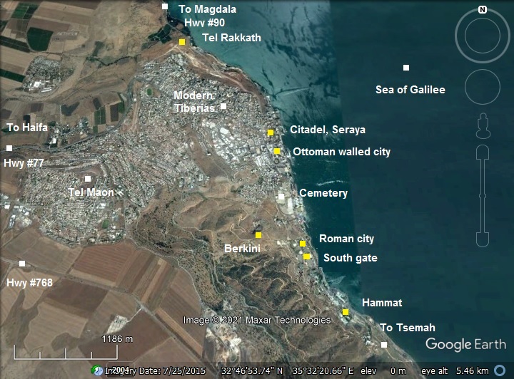
The city is located at the west side of the lake of Sea of Galilee. The old city is situated on its shore, at -200M (below sea level). The new city, with a population of 45,000, has spread out around the old section – to the sides and to the top of the hills around.
The city was first established on the southern side, and continuously expanded to the north over the 2 Millenniums of its history. Therefore, there are 4 major zones starting from the oldest in the south-
- South: the hot springs of Tiberias, and the old city of Hammat (now in ruins)
- Center: The Roman/Byzantine city (now in ruins), with the Bereniki hill on the west side
- North-Center : the walled Ottoman city, with the new high rising hotels
- North and up the hill – the modern Israeli city.
An aerial photo is shown below, indicating the major points of interest.
History:
- Early history
An ancient Canaanite city was located first in Tel Rakkath (Raqqat), a mound 2KM north of the Roman Tiberias.
Another village was located in Hammat, the hot springs town which today is in the south of the city.
-
Foundation of the Roman city
Tiberias was founded in 20/21 AD by Herod Antipas, son of Herod the great and Jewish ruler of the Galilee (4 BC-39 AD). He was appointed by Augustus Caesar as the ruler of Galilee and Peraea, the east bank of Jordan. Herod made the new city his capital, and named the city after the Roman emperor, Tiberius Caesar (see statue). Later (54 AD), the emperor Claudius added his name to the city – Tiberias Claudiupolis.

Bust of Tiberias Caesar; Istanbul Arch. Museum
Herod also minted coins in the city, with its name on it, thus showing its important role. He also used the coins as a means of propaganda, to encourage Jews to settle in the new city, since they refused to settle here (it was found that the city was built over an old cemetery). It took the city more than 110 years to find a religious way to overcome this problem, move the graves out and “Kosher” the city.
The first coin was minted by Herod Antipas at Tiberias in 20/21 AD. The coin, seen here below, shows an upright reed surrounded by Greek letters that read ‘of Herod Tetrarch’. Also it bears a date equivalent to 20/21 AD. It is made of bronze and is only 16mm in diameter. Presumably the reed on the coin was intended to indicate the location of the city, as reeds grew on the shore of the Sea of Galilee. (Thanks to Peter Lewis for this entry of the coin of his collection; permit Apr 5, 2013)

Coin of Herod Antipas
-
Jewish Revolt
During the Jewish revolt against the Romans, Josefus Flavius fortified it. However, when the Romans finally came, the city opened its gates to Vespasian – and was thus spared destruction.
After the revolt, at the end of the 1st century AD, the center of the Jewish population moved to the Galilee. The religious and administrative leadership, the “Sanhendrin“, moved to this city. It was its forth and last Galilee location (after Usha, Shefaram and Beit-Shearim), and marked the rising of the city’s importance in the post temple years.
-
Late Roman/Byzantine
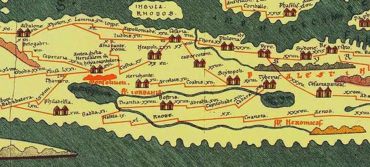
The city expanded during the good Roman and Byzantine years, and became one of the major cities in the Holy Land.
The Peutinger map (Peutingeriana tabula), based on a 4th century map of Imperial Roman roads, shows the major roads from Tiberias (shown as “Tyberias”):
-
south-eastern road through the south of Sea of Galilee (“Lac Tyberias”), across the Jordan to Gader (“Gabara”);
-
south road through Beit Shean (“Scytoplois”) and then to Jericho, Jerusalem and Caesarea.
- The north road from Tiberias to Banias and the east road through Capernaum to the east are not shown on the map.
-
Crusaders period
The Crusaders arrived from Europe to the Holy Land in order to liberate the Holy Land and free Jerusalem. They accomplished the mission in 1099, and established the Crusader Kingdom of Jerusalem.
They built a fortress inside the old city, on its waterfront. The city became the capital of the Principality of Galilee, one of the four major seigneuries of the Crusader Kingdom of Jerusalem. It was initially governed by Tancred – one of the 4 leaders of the first Crusade (1096-1099).
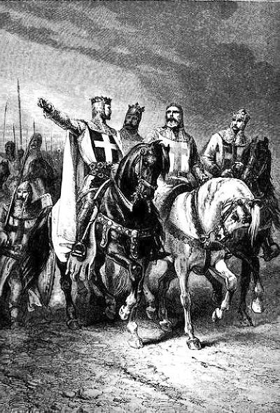
Leaders of the first Crusade – Godfrey de Bouillon, Raymond de Toulouse,
Bohemond de Tarento and Tancred d’Hauteville.
– by Gustav Dore (French artist, 1832-1883)
Until recently the location of the Crusaders fortress was unknown. New excavations (IAA news) have unearthed a section of its wall and a gate in the area of the old Jewish quarter near Etz Haim synagogue on the south east corner of the old city. It may have been buried in the area under the Greek Orthodox monastery.
The Crusaders rule of the city ended in 1187. On July 2 Saladin captured the city, and led a siege on the fortress. The Crusaders then sent for help to their comrades in Sepphoris. A rescue force was dispatched to Tiberias, but on July 4 they were defeated by Saladin’s forces in a decisive battle near the Horns of Hattin. This battle signaled the beginning of the end for the Crusaders rule in the Holy Land.
- Ayyubid and Mameluke periods (1187-1516)
The Rambam (Moses ben Maimon, Maimondies), one of the most prominent Torah scholars, died in Egypt in 1204. According to his will, he was brought to Tiberias for burial in 1205. His tomb is one of the most important points of interest in Tiberias.
Saladin, who led the military campaign against the Crusaders, founded the Ayyubid caliphate. The Ayyubids continued to rule over the Levant and surrounding territories until they were replaced by the Mamelukes (1250).
The Mamelukes were Turkish prisoners who were sold to the Sultan of Egypt, trained by him and served as his palace guards. In 1250 they seized the control of Egypt, and defeated the Mongols (1260). The Mamelukes ruled the Holy land until 1516, then replaced by the Ottomans. During these years Tiberias was a small town.
In the 14th to 15th centuries Tiberias was in ruins, with few dozens of residents living in poverty.
- Early Ottoman period (from 1516)
The city revived during the golden years of Sultan Suleiman the magnificent (1494-1566). He was the son of Selim I, who defeated the Mamelukes and ruled their vast territories. Suleiman brought in legal and political reforms, a golden age of cultural developments, and is known for his notable construction projects, such as restoring the Dome of the Rock shrine and walls of Jerusalem.
- Joseph and Dona Nasi
In 1561 Suleiman allowed Joseph Nasi (aka João Micas, 1524-1579), a Jewish Portuguese merchant from Istanbul, to head the Jewish community in Tiberias and to rebuild the city and its villages. His aunt, Dona Garcia Nasi (1510-1569), was one of the richest women in 16th century Europe. She founded synagogues and Jewish social institutions across Europe and in Constantinople. Dona leased the town of Tiberias from the Sultan for a yearly sum of 1000 ducats of Gold, establishing a Jewish state in Tiberias. Dona commissioned the construction of the city walls (1566) as well as other projects. Although Dona never lived in the city, she brought a great change to the landscape. In 2010 a memorial plate was erected in the forest above Tiberias, honoring 500 years of her birth.
The Jewish prosperity did not last long, as they were forced to leave the town in the beginning of the 17th century. Tiberias then returned to be a small and ruined town.
- Daher el-Omar
The big change came in the 18th century. Daher el-Omar mutinied against the Ottoman empire, capturing the area of the Galilee and establishing a self governed province in the years 1730-1775. Daher and his family fundamentally reshaped the Galilee landscape by building fortresses, warehouses, khans and administrative buildings.
Daherel-Omar was born in the Galilean village of Arraba in 1690, son of a rich Sunni Muslim family from Tiberias. He first conquered and fortified the town of Tiberias on the shores of the Sea of Galilee (1730). He fortified Tiberias, repairing the city wall, and made Tiberias his capital city. He encouraged the Jewish population to settle in Tiberias, and increased the Muslim population by building the el-Amari mosque (1743).

A Bedouin warrior – Library of Congress, American Colony
After successfully withstanding a siege of the Ottoman army from Damascus in Tiberias (1742), he conquered Shefaram (1742), fortified it and later moved his headquarters to this western Galilee town. After capturing Acre (1746) he refortified it (1750), and moved his headquarters to Acre. He left his eldest son Salibi (Sulaybi) al-Zahir in charge of the city. In 1773 he appointed his brother Ahmad al-Zahir to govern the city, following the death of Salibi in a battle.
The Jewish quarter was located on the east side of the walled city, in an enclosed area along the water front. The quarter was protected by a high inner wall, built in the middle of the 18th century, with a western gate. The Muslim quarter was in the northwestern area, while the few Christians lived in the south western area.
In 1831-1833 the Galilee, including Tiberias, were reconquered by the Egyptian Ibrahim Pasha.
-
Late Ottoman period
On Jan 1, 1837, a strong earthquake hit the city, toppling sections of the city walls and most of the buildings. More than 700 persons were killed and the city was in total ruins. According to an eye witness report, fire erupted from the lake (?) and the city was flooded. An illustration by a traveler, Conte de Laborde, shows a total devastated city.
About 2 years after the earthquake, David Roberts painted this picture of Tiberias, with a view from the south west, in 1839. Notice the old city walls that surrounded the city, and the Tiberias citadel on the north west corner of the walled city. There are just a few buildings drawn in this illustration, as Roberts may have simplified his drawing. Nevertheless, most of the private structures have collapsed in the Muslim and Christian quarters. Prior to the earthquake there were 550 buildings (as per the traveler W. Turner in 1815). The public structures and sections of the wall were damaged but were still standing after the quake.

David Roberts 1839; Photos of the Library of Congress
The next drawing by David Roberts is a closer view inside the city, as seen from the southern side.
Roughly 60 years later than these illustrations, the city grew considerably. It attracted the Jewish population as it was considered to be one of the 4 Holy Jewish cities (other are Jerusalem, Safed and Hebron). From only 712 Jewish residents in 1839, the Jewish population grew in 1867 to 2530. At the end of the Ottoman period, the majority of the population was Jewish.

David Roberts 1839; Photos of the Library of Congress
In 1905 the transportation to the city improved, with a new railroad that reached the south point of the lake. Boats carried visitors and merchants across the lake from the railroad station in Tsemah (Samakh) to the city. The city continued to grow. Its protecting walls provided security and order.
A southern view from the citadel is seen here at the end of the 19th century.

View from the Tiberias citadel (1890-1900); Detroit Publishing Co., catalogue; Photos of the Library of Congress
At the beginning of the 20th century the city was still located inside the area bounded by the Ottoman period wall. By that time the whole walled city reached to full capacity. The first 3 houses were built in 1911 outside the walled city, starting the modern expansion of the city towards the west.
An aerial view of Tiberias is seen here as captured from the north east. The 3 houses, that first built outside the walled city, are seen here as connected houses just outside the wall.

Series of first aerial photographs of Palestine and Syria – American Colony (1917); American Colony Photos of the Library of Congress
- British Mandate (1918-1948)
The city was captured by the British forces on Sep 25, 1918.
On May 15, 1934, a great mudslide covered parts of the city, knocking down 100 houses and killing dozens of people.
During the Israeli independence war the city witnessed fierce battles. On April 19 1948, Tiberias was the first city in Israel to be liberated.
- Modern period
In 2020/2021 Tiberias celebrates exactly 2000 years since it was founded. Its population is about 45,000.
Photos:
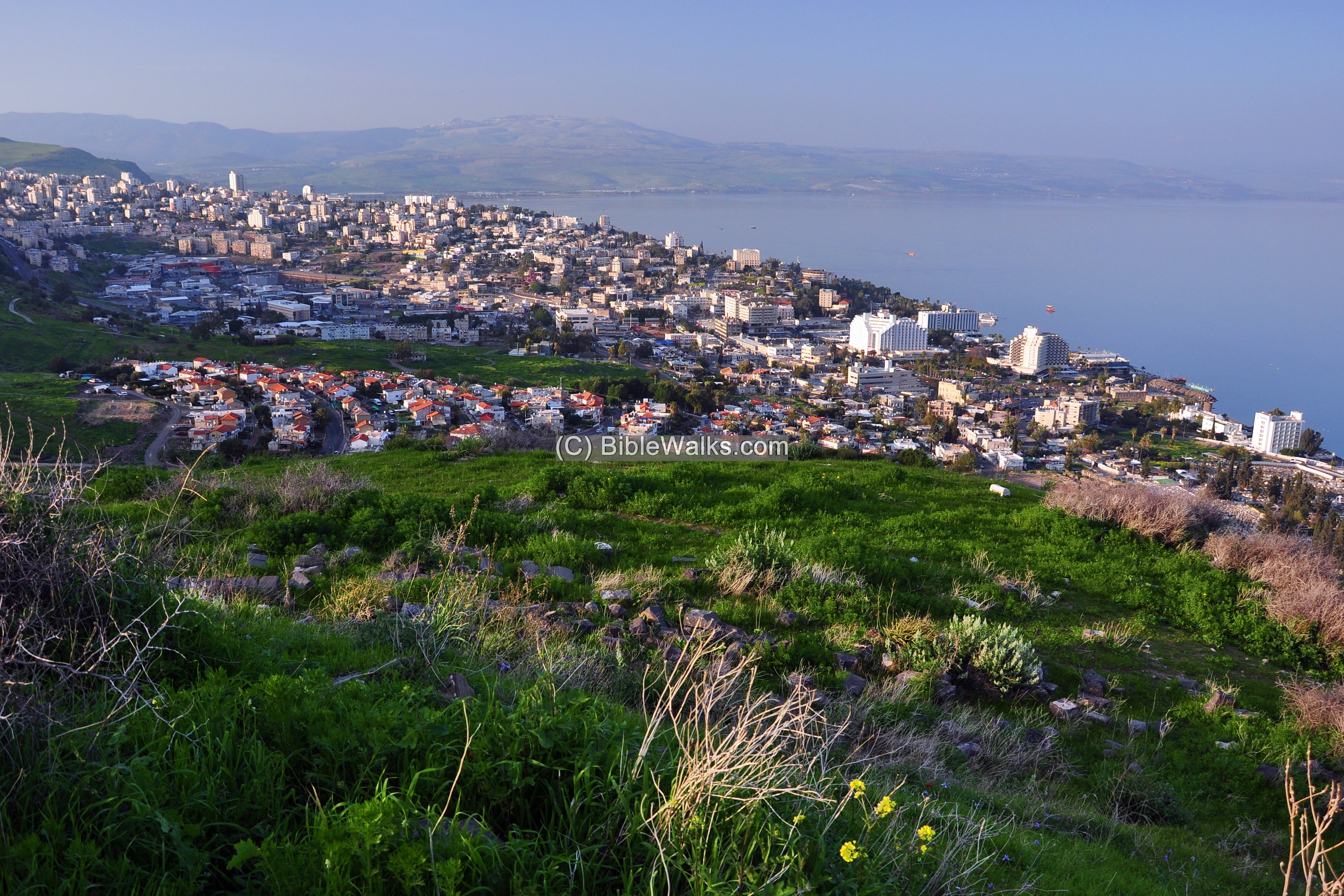
(a) General view of the city
Tiberias is segmented to 3 parts – the Roman/Byzantine on the south, Crusaders/Ottoman on the north, and the modern city occupying the space of the Ottoman walled city and the areas north and up the hill.
This is a view from the Berniki hill. The modern city buildings are seen spread on the foothills, reaching to the waters of the Sea of Galilee. Along the shore are the high rising hotels, which is where the location of the Ottoman old city.
Click on the photo to view it in higher resolution…
From the same spot – a view towards the south of the modern city. Below the hill and along the shore are the ruins of the Roman/Byzantine city. Beyond, at the edge of this view, was the town of Hammat.
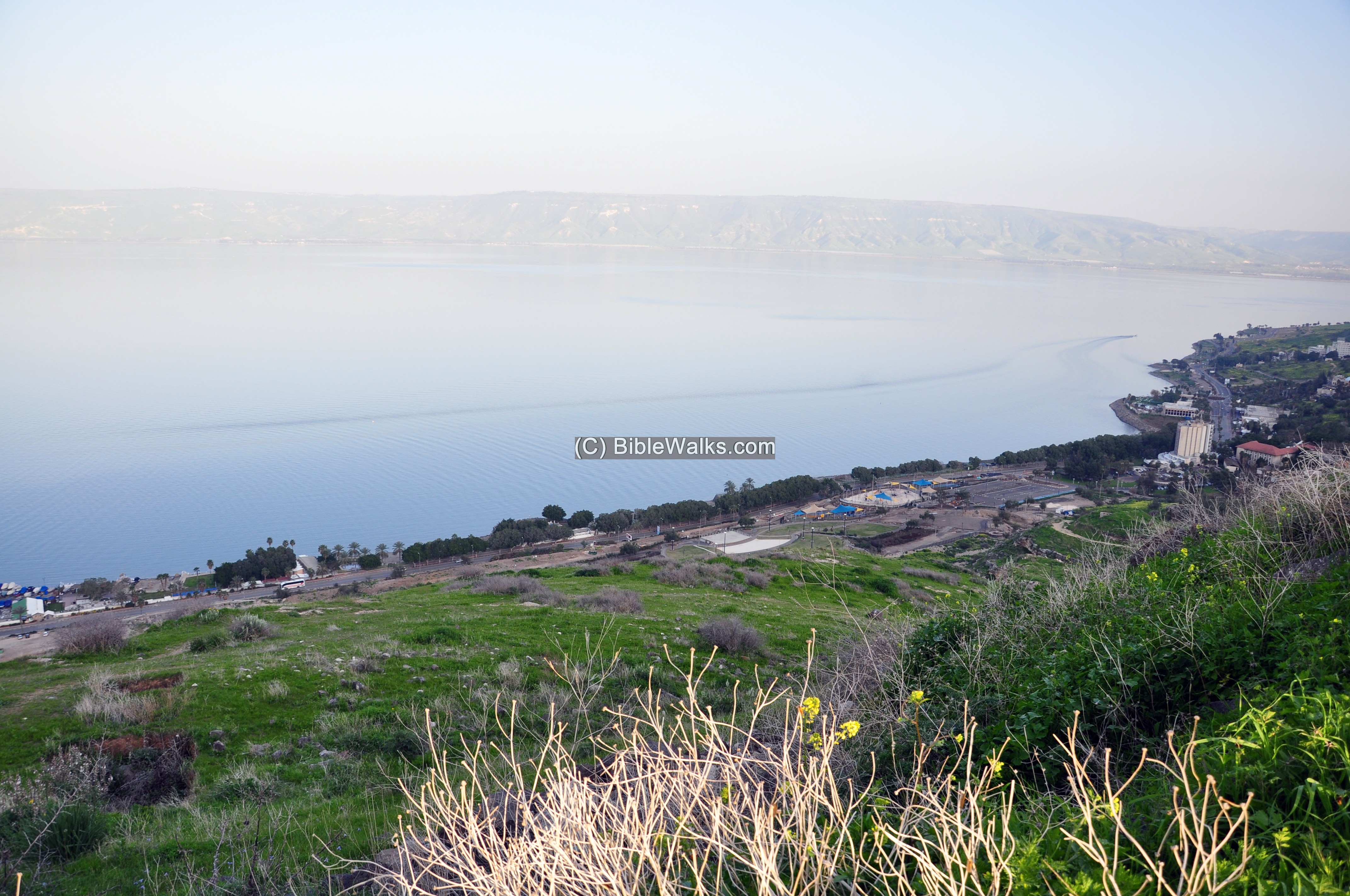
(b) South East
During the medieval period the city moved north of the Roman/Byzantine period city.
The following view is of the southern side of the Ottoman wall. The city walls are from the 18th century AD, during the Ottoman period, built by the Bedouin Daher El-Omar at 1740. They were initially built Dona Garcia Nasi in 1566. Excavations along the wall (2007) confirmed these phases of construction. An earlier Crusader wall may have predated both 16th and 18th century walls. There were 2 gates to the walled city – a western main gate and a smaller south gate.
Modern salvage excavations (2020) in this open area revealed a large industrial area, dated to the early Islamic period ( 8th to 11th century -Abbasid). In the excavation area the archaeologists revealed structures, stores, ceramic ovens, aqueduct, toilets, molds for oil lamps, as well as other installations.
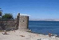
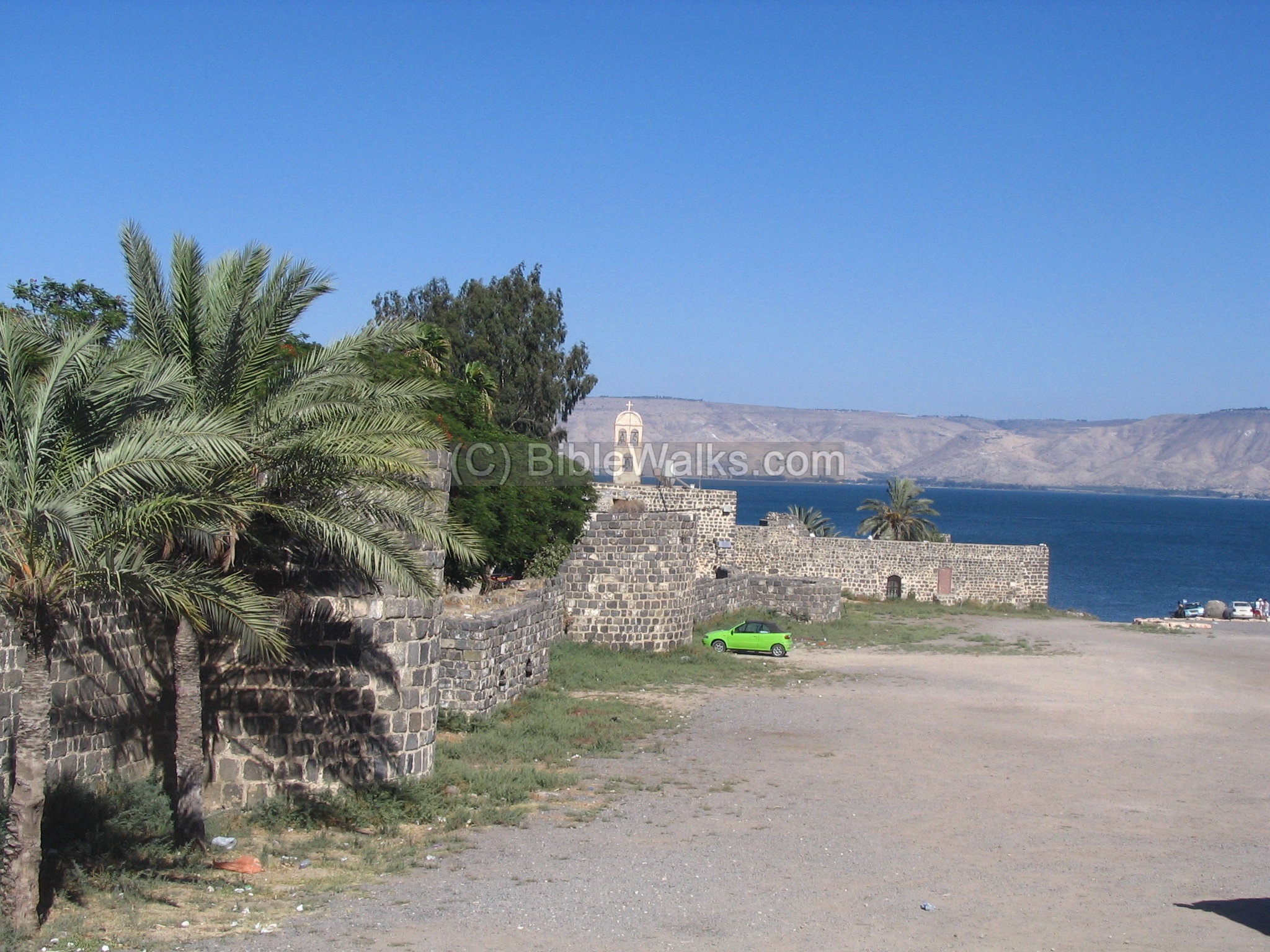
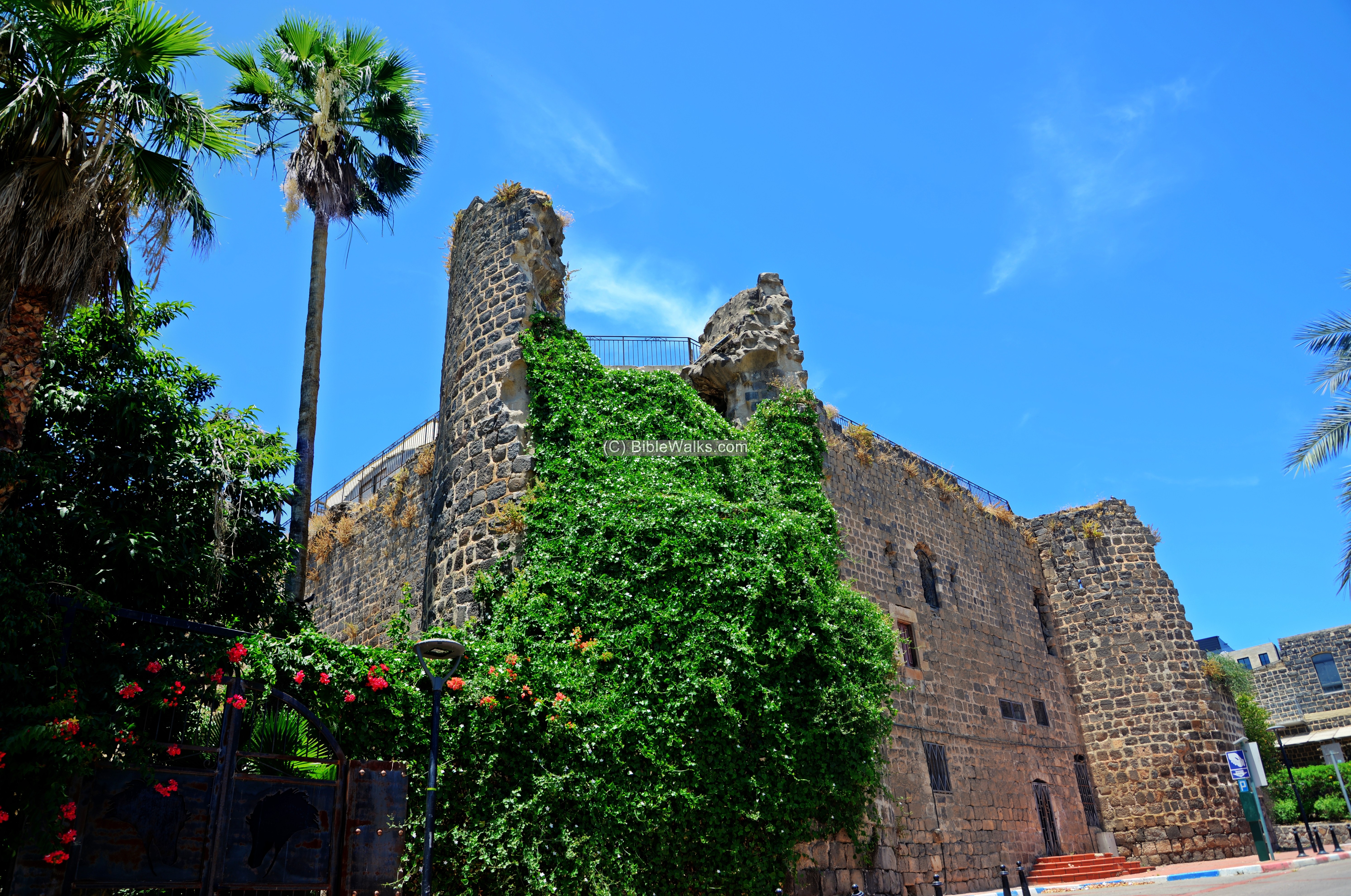
Next view – the south east corner with the ‘leaning tower’. The corner tower, leaning towards the sea, is one of the symbols of the city. It is one of the 21 circular turrets that were built along the 18th century wall. The leaning may have been a result of the 1837 earthquake.

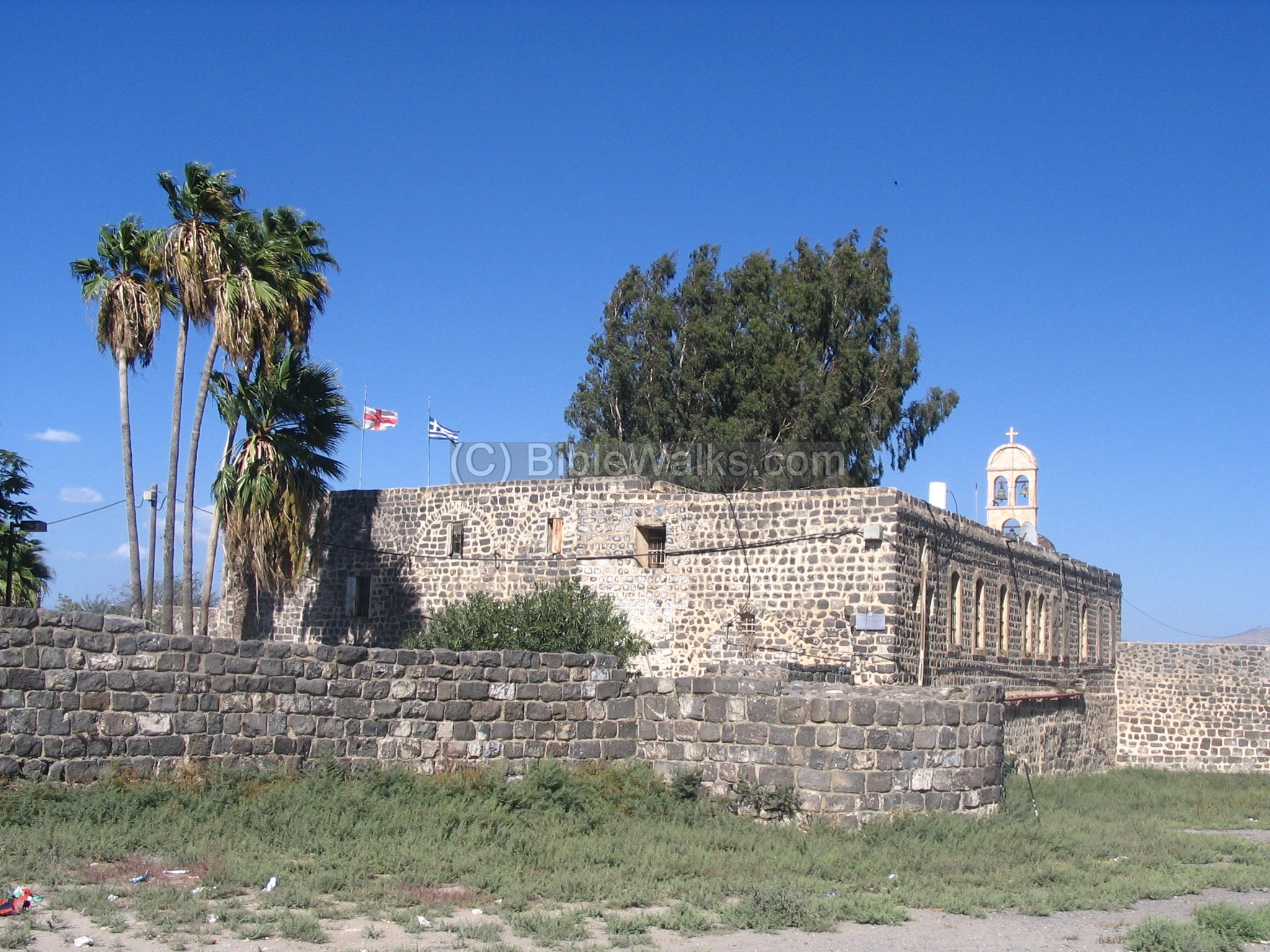
Adjacent to the leaning tower, behind the Ottoman wall, is the old Greek orthodox church.
The Church was probably built over sections of the Crusaders fortress.
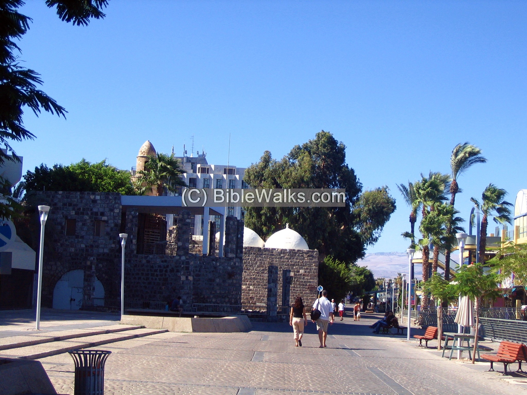
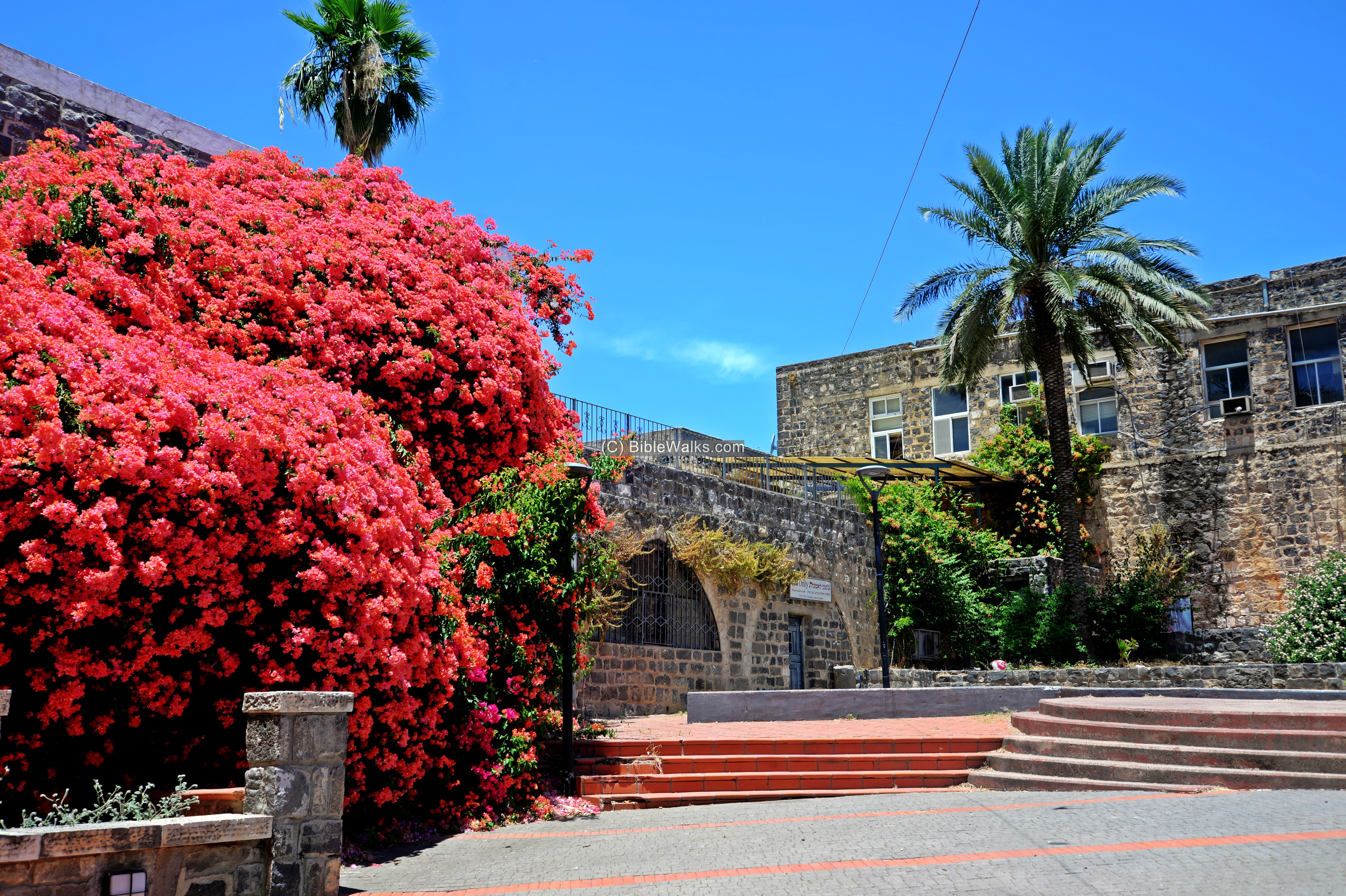
(c) Hotels and Tourism
Tourism is one of the city’s main income. In the photo are the new and the old – the Ottoman walls in the foreground, and one of the high rising hotels in the background.
This round turret was part of the 18th century city wall. It was damaged in the 1837 earthquake.
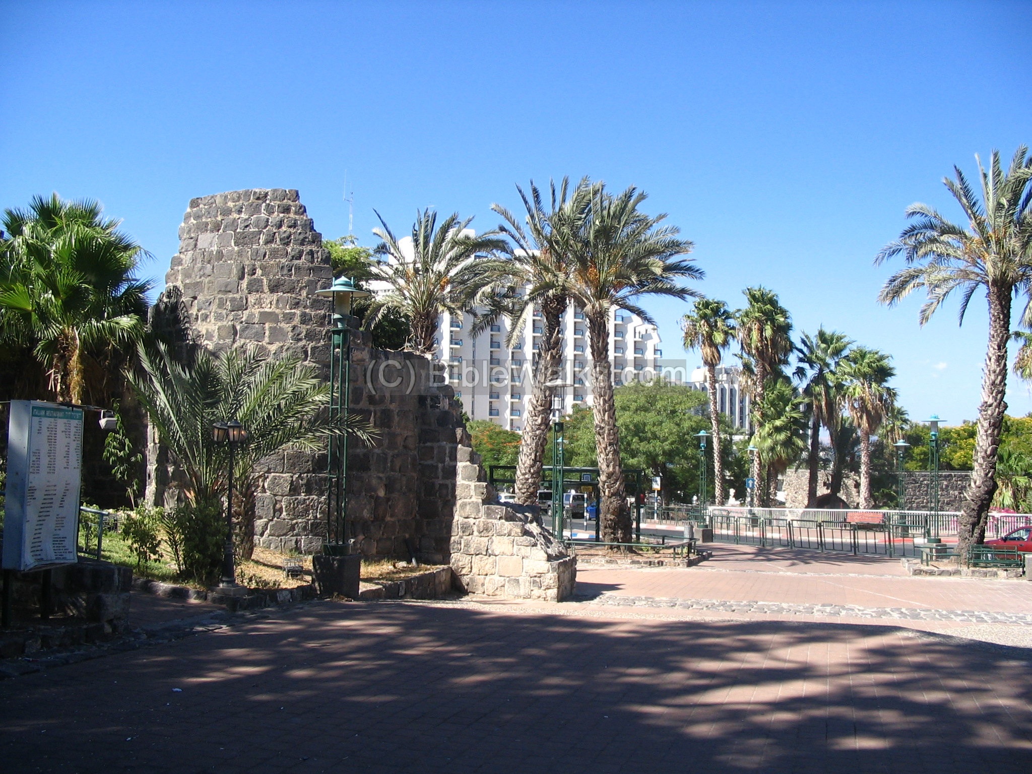
Along the water front are restaurants and shops. Historic structures, like the ruins of the al-Bachri Mosque (Sea mosque), are seen along the promenade.
Tiberias is located on the shores of the sea of Galilee, where there is a lot of sportive activities. The hot and dry weather, the sweet water, and the calming atmosphere of the lake – makes it a favorite vacation-land.

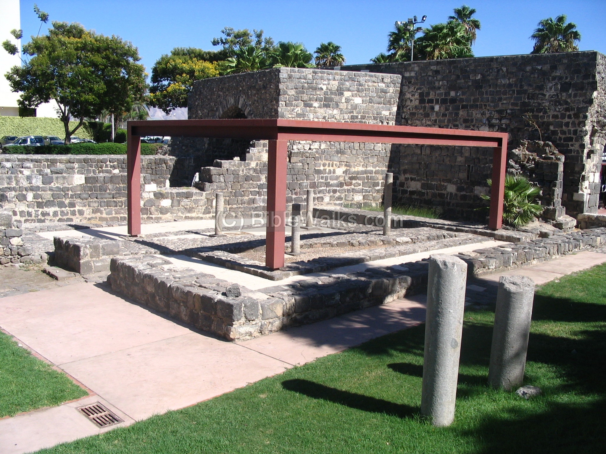
(d) Archaeological Park
Near the high rising hotels there is an open museum and a tourist center that shows some of the antiquities.
(e) Tiberias Citadel and Seraya
On the north west side of the walled city, near the Scottish hotel, was the Tiberias Citadel. It was built in 1745 by Salibi, the son of Daher el-Omar.
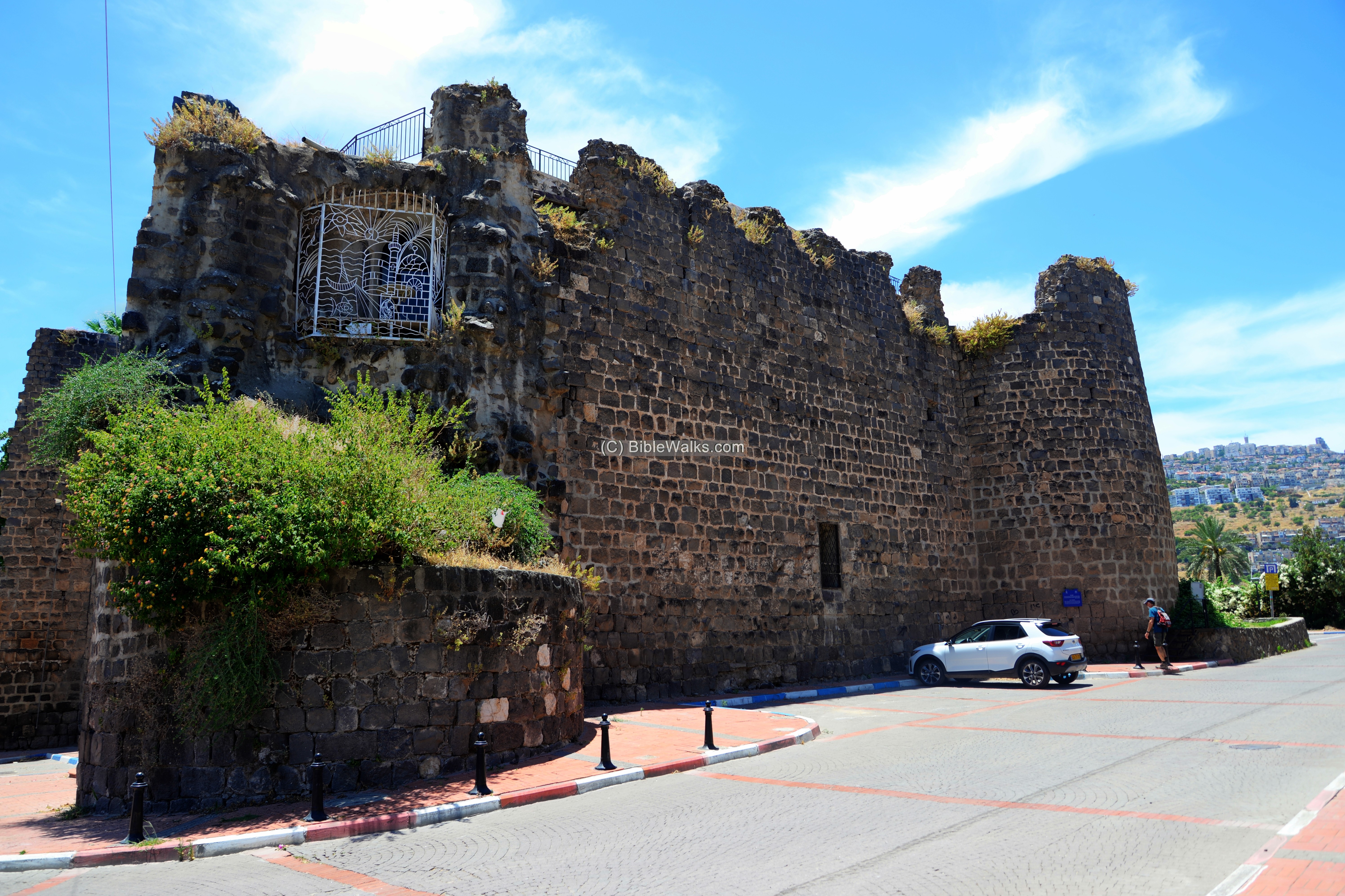
The fortress is part of the Ottoman wall that encircles the old city. The two story structure has 4 corner towers, built with basalt stones reused from earlier structures.
Nearby is the 19th century building of the Seraya – the Ottoman governmental headquarters.
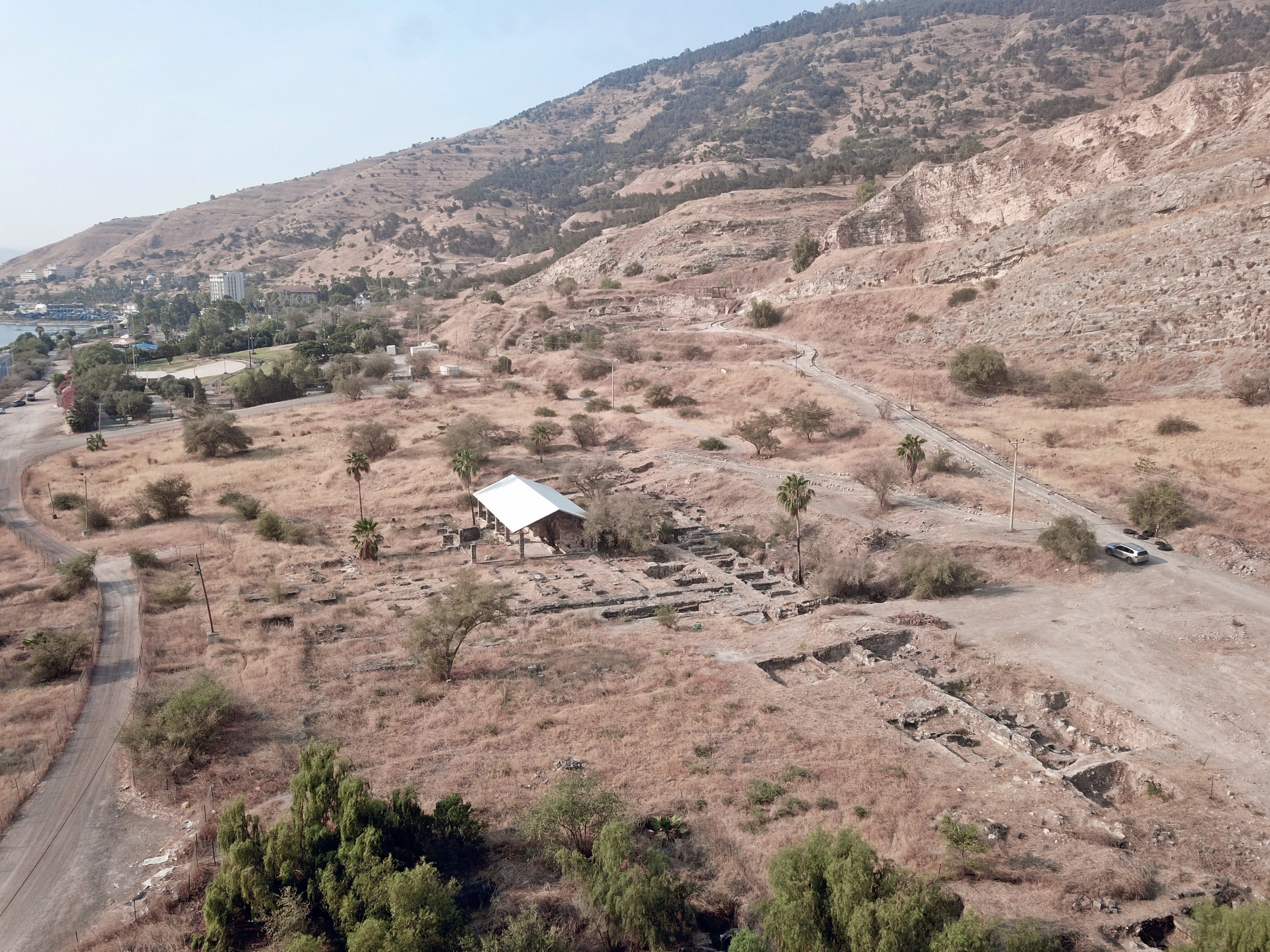
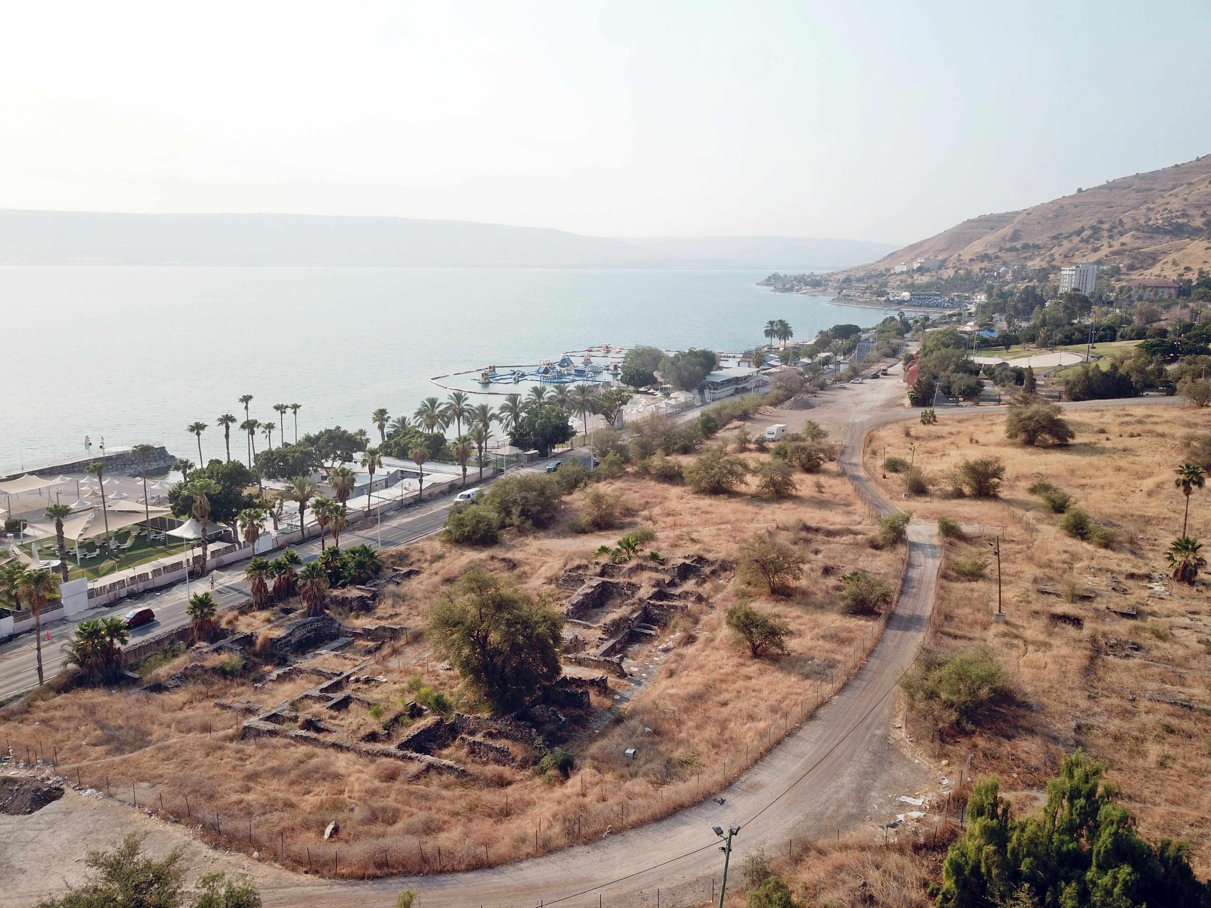
(f) Roman/Byzantine Tiberias
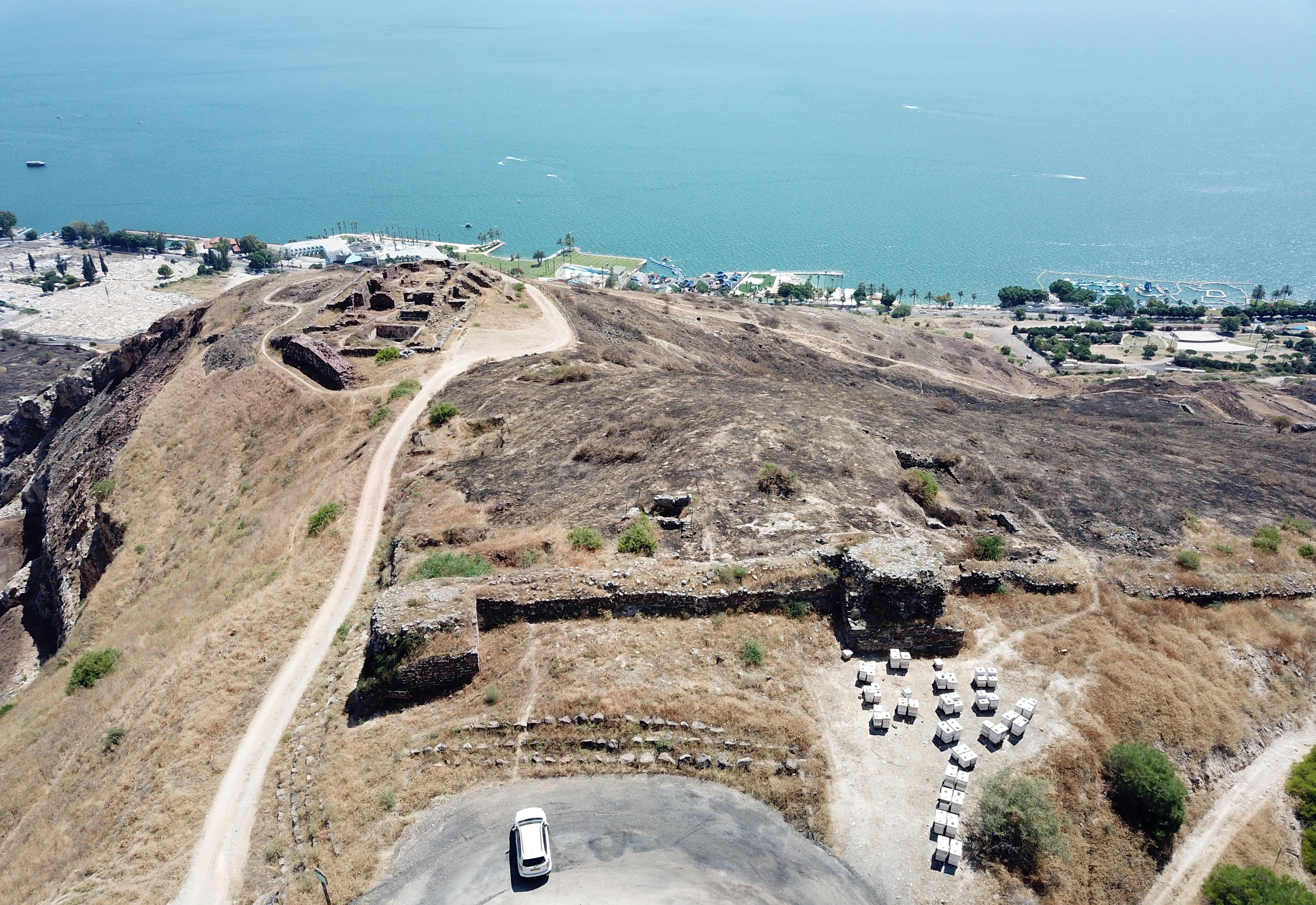
Roman/Byzantine Tiberias was located to the south of the walled Medieval city. Under most of the area lie the ruins of the ancient city. Some of them were unearthed in the past century. The following drone view towards the south shows a number of such sites, that are detailed below and in additional pages.
The hill that towers to the south of the old city is Mt Berniki, touring 190M and west of above the Roman city. The hill is named after the sister of King Agrippa II.
Ruins of a church are located at the edge of a cliff, at the western edge of the Roman/Byzantine city area. In this aerial view the Byzantine wall is seen in the foreground, with twin towers that protected the western side. Each tower is 7.5m square, once reaching a height of 15m. The wall continues towards the cliff, passing along the north west corner of the church.
![]() For more information on the Berniki Hill – see its separate web page.
For more information on the Berniki Hill – see its separate web page.
(2) South Gate:
On the south-eastern foothills of Berniki hill, 300+ meters south of the Roman city center, is the location of the southern walls and gate of the Roman and Byzantine city. The 1st century Roman gate complex and a Roman bridge were recently excavated and reconstructed, as part of the new archaeological park.
![]() For more information on the south gate – see its separate web page.
For more information on the south gate – see its separate web page.
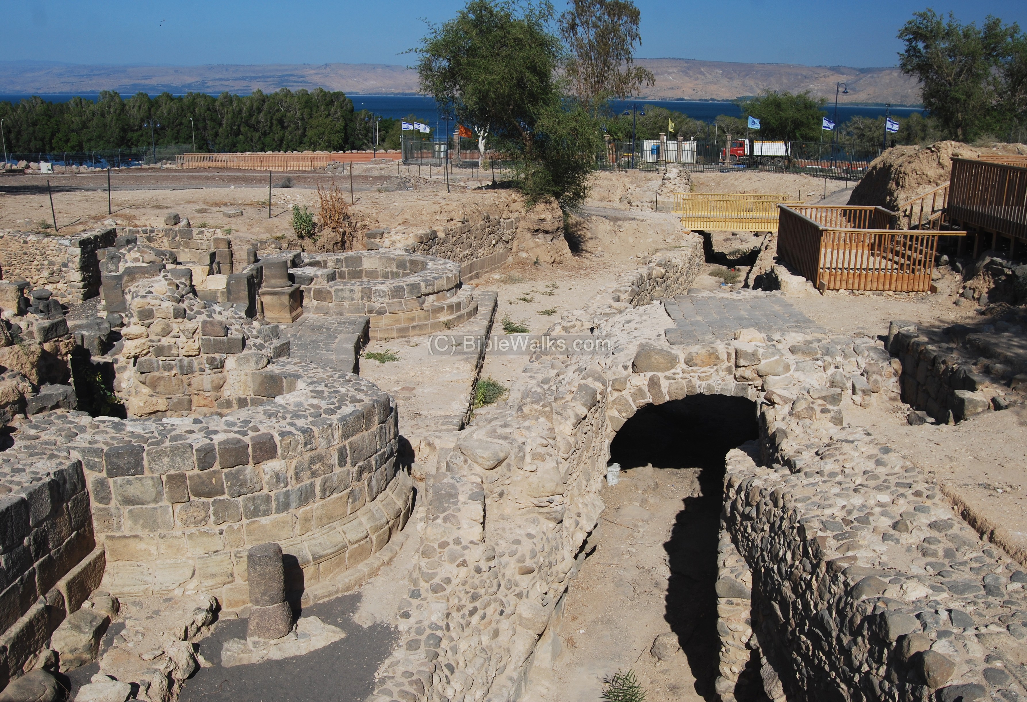
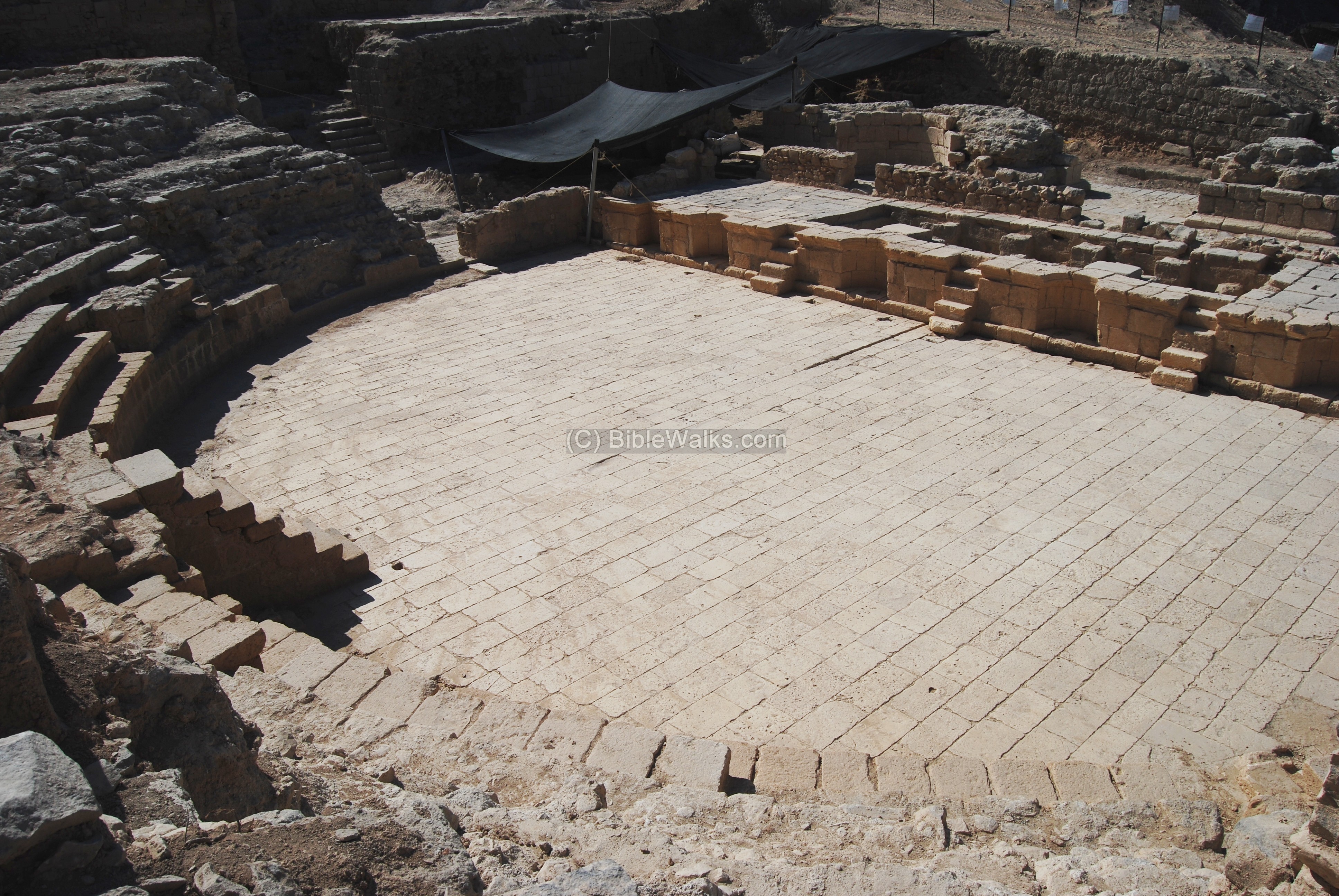
(3) Roman Theater:
To the north of the south gate are the ruins of the Roman Theater, seen in the photo below. Constructed in the 1st century AD, enlarged in the 2nd century, it had seating capacity of 7,000 people. It is also recently excavated and reconstructed, as part of the new archaeological park.
![]() For more information on the Theater – see its separate web page.
For more information on the Theater – see its separate web page.
(4) City Bathhouse
The main city bathhouse of Roman Tiberias is adjacent to Cardo Maximus and the city market.
![]() For more information on the Bathhouse – see its separate web page.
For more information on the Bathhouse – see its separate web page.
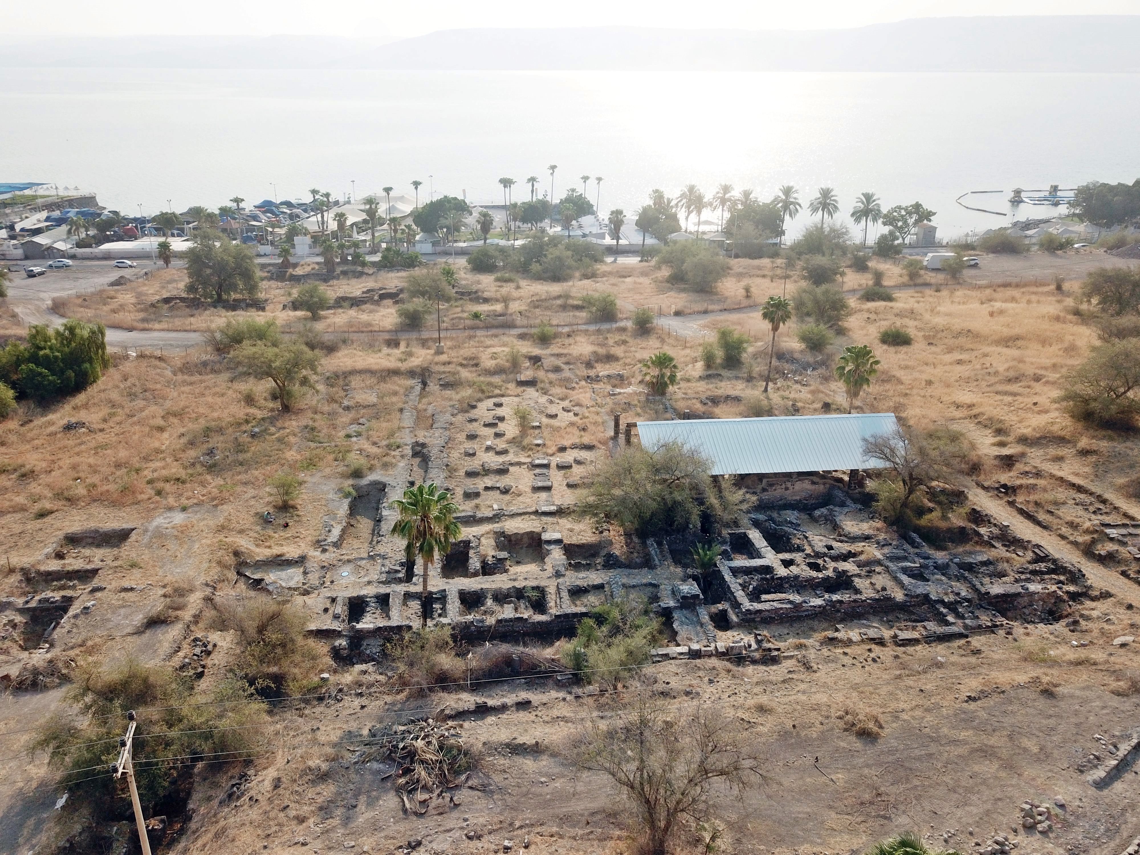
In central Roman–Byzantine Tiberias, archaeologists uncovered the remains of a vast structure complex—over 2,000 square meters, with about 25 rooms.
![]() For more information on the Basilica – see its separate web page.
For more information on the Basilica – see its separate web page.
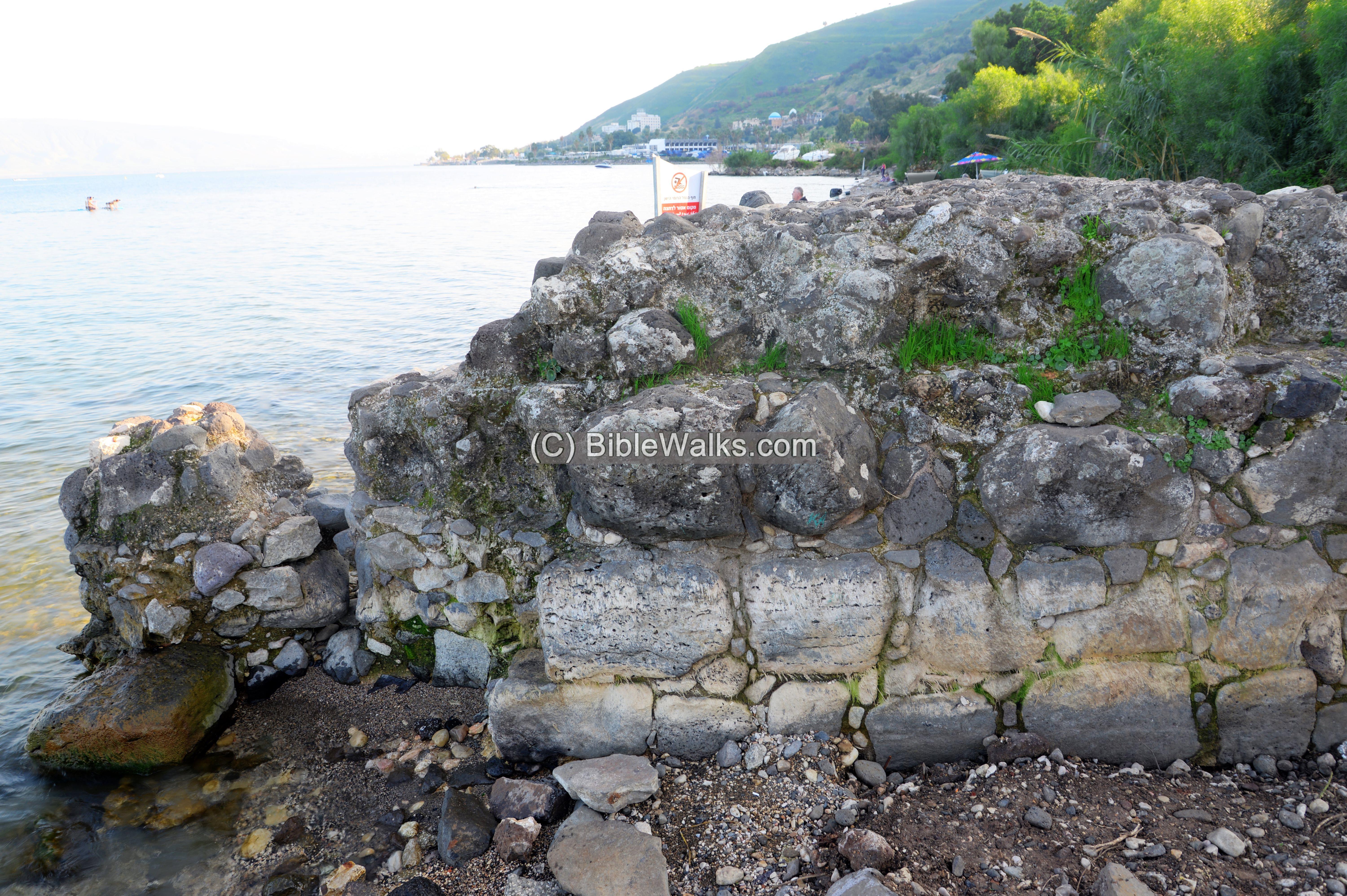
(6) Miriam’s Well
Remains of “Miriam’s well”, “Long Structure”, and the southern Byzantine city wall.
![]() For more information on the Miriam’s well – see its separate web page.
For more information on the Miriam’s well – see its separate web page.
More sites of the Roman city will be added soon…
Old Testament References:
(a) Joshua 19:32,33,36
The city preceding Tiberias is Rakkath (Raqqat), which is one of the cities that were within the territory of the tribe of Naphtali. Note that Hammat is the city of the hot springs of Tiberias, which is also listed here.
“The sixth lot came out for the children of Naphtali, even for the children of Naphtali according to their families.
And their border was… “
“… And the fortified cities were Ziddim-zer, and Hammath, and Rakkath, and Chinnereth;”
New Testament References:
There are just a few references of Jesus visiting or acting in Tiberias. This is initially surprising, as the city was the capital of the area. This may be due to the fact that there was a small Jewish presence in the city at its beginning. The city is referred in the context of the “sea of Tiberias”, another name for the sea of Galilee after the city gained it fame and importance.
(a) John 6:1, 23
“After these things Jesus went over the sea of Galilee, which is the sea of Tiberias…. Howbeit there came other boats from Tiberias nigh unto the place where they did eat bread, after that the Lord had given thanks”.
(b) John 21:1
“After these things Jesus shewed himself again to the disciples at the sea of Tiberias; and on this wise shewed he himself”.
Historical References:
(a) Josephus Flavius (Antiquities, Book 18 Chapter 2:3)
Josephus, the commander turned historian, tells about the foundation of the city, and that Jews refused to settle there since it was previously a cemetery.
“And now Herod the tetrarch, who was in great favor with Tiberius, built a city of the same name with him, and called it Tiberias. He built it in the best part of Galilee, at the lake of Gennesareth. There are warm baths at a little distance from it, in a village named Emmaus. Strangers came and inhabited this city; a great number of the inhabitants were Galileans also; and many were necessitated by Herod to come thither out of the country belonging to him, and were by force compelled to be its inhabitants; some of them were persons of condition. He also admitted poor people, such as those that were collected from all parts, to dwell in it. Nay, some of them were not quite free-men, and these he was benefactor to, and made them free in great numbers; but obliged them not to forsake the city, by building them very good houses at his own expenses, and by giving them land also; for he was sensible, that to make this place a habitation was to transgress the Jewish ancient laws, because many sepulchers were to be here taken away, in order to make room for the city Tiberias whereas our laws pronounce that such inhabitants are unclean for seven days”
(b) Josephus Flavius (Wars- Book II, 20, 6)
Josephus fortified Tiberias:
“Josephus … knew the Romans would fall upon Galilee, he built walls in proper places … and Tiberias.”
(c) Josephus Flavius (Wars- Book III, 9, 8)
The citizens of Tiberias opened the gates, and the Romans spared the city:
“The next day Vespasian sent Trajan before with some horsemen to the citadel, to make trial of the multitude, whether they were all disposed for peace; and as soon as he knew that the people were of the same mind with the petitioner, he took his army, and went to the city; upon which the citizens opened to him their gates, and met him with acclamations of joy, and called him their savior and benefactor. But as the army was a great while in getting in at the gates, they were so narrow, Vespasian commanded the south wall to be broken down, and so made a broad passage for their entrance. However, he charged them to abstain from rapine and injustice, in order to gratify the king; and on his account spared the rest of the wall, while the king undertook for them that they should continue [faithful to the Romans] for the time to come. And thus did he restore this city to a quiet state, after it had been grievously afflicted by the sedition”.
Etymology (behind the name):
-
Tiberias – city dedicated to the Emperor Tiberius
-
Tveria – name of the city in Hebrew (טבריה)
-
Hammat/Khamat – from the Hebrew root word “Kham” – which means hot, due to the hot springs.
Links:
* External:
- Recent Excavations in Tiberias (IAA)
- Excavations on Facebook group page
- Tiberias – Final report – Yosef Stepanski (HA 119 2007) – on excavations along the southern city wall (corner Habonim and HaGalil st)
- Tiberias, Map survey – Yosef Stepanski (HA 117 2005) – on survey around Tiberias
- Where was the Crusaders fortress? (IAA, Hebrew)
- Damage patterns of earthquakes in Israel and its vicinity: Evaluation according to the historical sources – Motti Zohar (2016 GSI Thesis; pdf) – see pages 55-73 for 1837 earthquake in Tiberias.
* Tiberias sites in BibleWalks:
- Tiberias (overview)
- Tiberias South Gate
- Berniki Hill
- Theater
- Bathhouse
- Basilica
- Miriam’s Well
- Hammat Tiberias
- Berniki aqueduct – section in Horvat Kush; Survey Video
* Other internal links:
- Roman Roads and Streets
- Earthquakes in the Holy Land
BibleWalks.com – walk with us through the sites of the Holy Land
Orth., Capernaum <<<–previous site—<<< All Sites>>> —-next Sea of Galilee site –>>> Tiberias South Gate
This page was last updated on Aug 19, 2025 (add Miriam’s well)
Sponsored links: