Tel Par was a Biblical village, part to the Asher tribe. Its identification is not certain, and may be “Beten” from the book of Joshua.. In later periods the site relocated to the nearby site of Kh. Ibtin.

Home > Sites > West Galilee > Tel Par (Tell el Far) and Kh. Ibtin
Contents:
Background
Location
History
Aerial Map
Photos
Biblical
References
Etymology
Links
Background:
Tel Par (Tell El Far) is a small oval mound, located in the plains west of Ibtin. It was inhabited in the Bronze and Iron Age periods. The site was suggested as the Biblical ‘Beten’, part of the region of Asher.
Khirbet Ibtin is located east of Tell Par, and was probably the continuation of the older site.
Location:
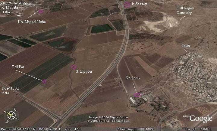
The Tel is located near the village of Ibtin, on the north-west side of the junction of the modern roads (Yagur-Somech and the road to Kiryat Atta).
The ancient Via-Maris road passed at this site for thousands of years. Tell Par was located on the main north-south road from Syria, through Acre, down to the center of Israel and Egypt. A Roman milestone was found nearby. Note that Via-Maris split to 2 forks in Khirbet Gedura (near Kefar Bialik), and this section was the eastern route that passed through Kiryat Atta to Tell Regev.
Tel Par site got its waters from the Zippori creek which passes at this point, on its way south towards the Kishon river. The crossing over the creek was another advantage of the site.
The following aerial view shows the points of interest. Tell Par is located north-west of the new road, and west of Kh. Ibtin.
History of the place:
(a) Canaanite-Biblical periods: Tell Par
According to the archaeological survey, the ancient city was inhabited during the Middle Bronze (Canaanite) period (2200-1550BC), Late Bronze period (1550-1200 BC), Iron Age II-III (1000-576 BC), and Persian period (539-332 BC).
The site was identified as biblical “Beten” by Y. Aharoni and other scholars.
It might have been in one of the cities given to Hiram, King of Tyre, as part of the pact with King Solomon (Kings I). However, according to Y. Aharoni it remained under King Solomon’s area and was a border city with the Phoenicians.
A Biblical map of the area shows the position of the city (marked with a red square). It lies along the main coastal highway, north of Tel Regev. The coastal highway continued north thru Tel Zavat and Tel Gedra (Jidru) (south and north of modern Kefar Bialik) to Aphek.
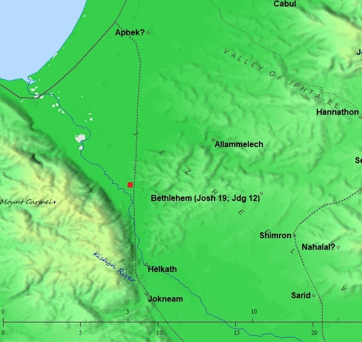
Map of area around the site (red square) – from the Canaanite thru the Roman periods (based on Bible Mapper 3.0)
(b) Roman/Byzantine periods: Khirbet Ibtin
In the Byzantine period Tel Par was reused as a farming house. Today it is ruins and damaged from the farming around the site, and hardly noticed while driving at the nearby highway.
500M East to Tel Par, on the footsteps of the hills, there is a site from later periods (Roman, Byzantine, Mameluk and Ottomon period). This site may have been the second phase of Tel Par, which was too small for that period. The newer site may have also preserved the name of the ancient site – Beten, which is listed in Joshua as one of the cities in the region of the tribe of Asher.
(c) Ottoman
At the end of the Ottoman period a large farm was built on the ruins of Khirbet Ibtin.
The area was examined in the Palestine Exploration Foundation (PEF) survey (1866-1877) by Wilson, Conder and Kitchener. A section of their map is here.
Tel Par (Tell el Far) appears on the east side of the main road (a double dashed line) connecting the south, via Jidru (today, Kefar Bialik) to the coastal road to the north.
To the east are ruins of Abtun (khirbet Ibtin). Nearby, to the south, is the larger ancient city – el Harbaj (Tel Regev).
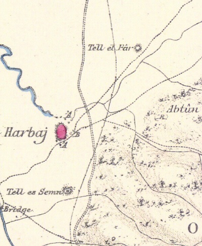
Part of Map Sheet 5 of Survey of Western Palestine,
by Conder and Kitchener, 1872-1877.
(Published 1880, reprinted by LifeintheHolyLand.com)
The surveyors wrote about the site (Volume 1, Sheet V, p. 352):
“Tell el Far —A small mound, apparently artificial, with traces of ruins”.
(f) British Mandate Period
A 1940s British map shows the area around the sites in detail. The Biblical mound of Tell Par (Tell el Far) is on the north bank Wadi el Malik (Zippori stream), and east of the modern road. Khirbet Ibtin, A Roman period village, is located south east of the ancient mound.
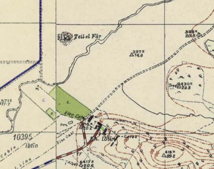
British survey map 1942-1948 – https://palopenmaps.org topo maps
License: public domain under the UK Copyright, Designs and Patent Act 1998
(g) Modern
A Bedouin village was later (1965) established on the higher side of the hill above Khirbet Ibtin. It was incorporated into the Zevulun regional council. Today (2009) there are 2,500+ residents in Ibtin.
Photos:
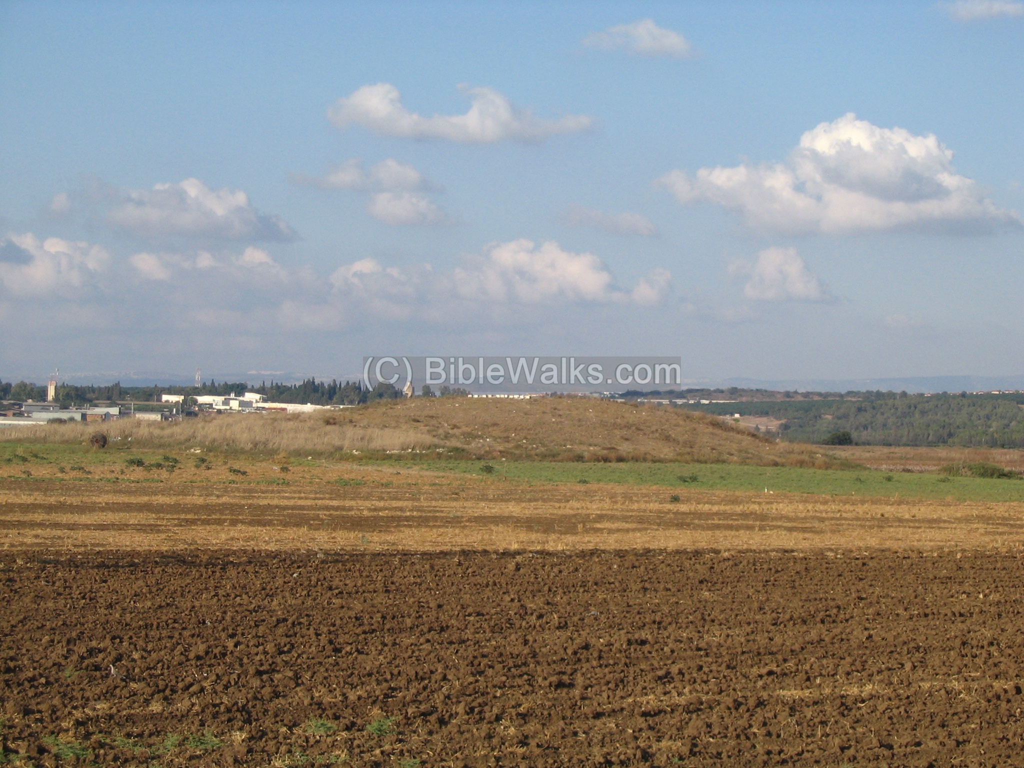
(a) Tell Par:
The following photo shows the small Tel Par from the south. The mound height is 9m above the area around it, covering 9 dunams. Its shape is oval with a flat summit.
The surveyors noticed on its flat summit traces of structures.
It is hard to image a “city” in this tiny, low hill. However, this small mound is really the “tip of the iceberg”, since most of the Canaanite ruins are located deep under the ground around the site.
Click on the photo to view it in higher resolution…
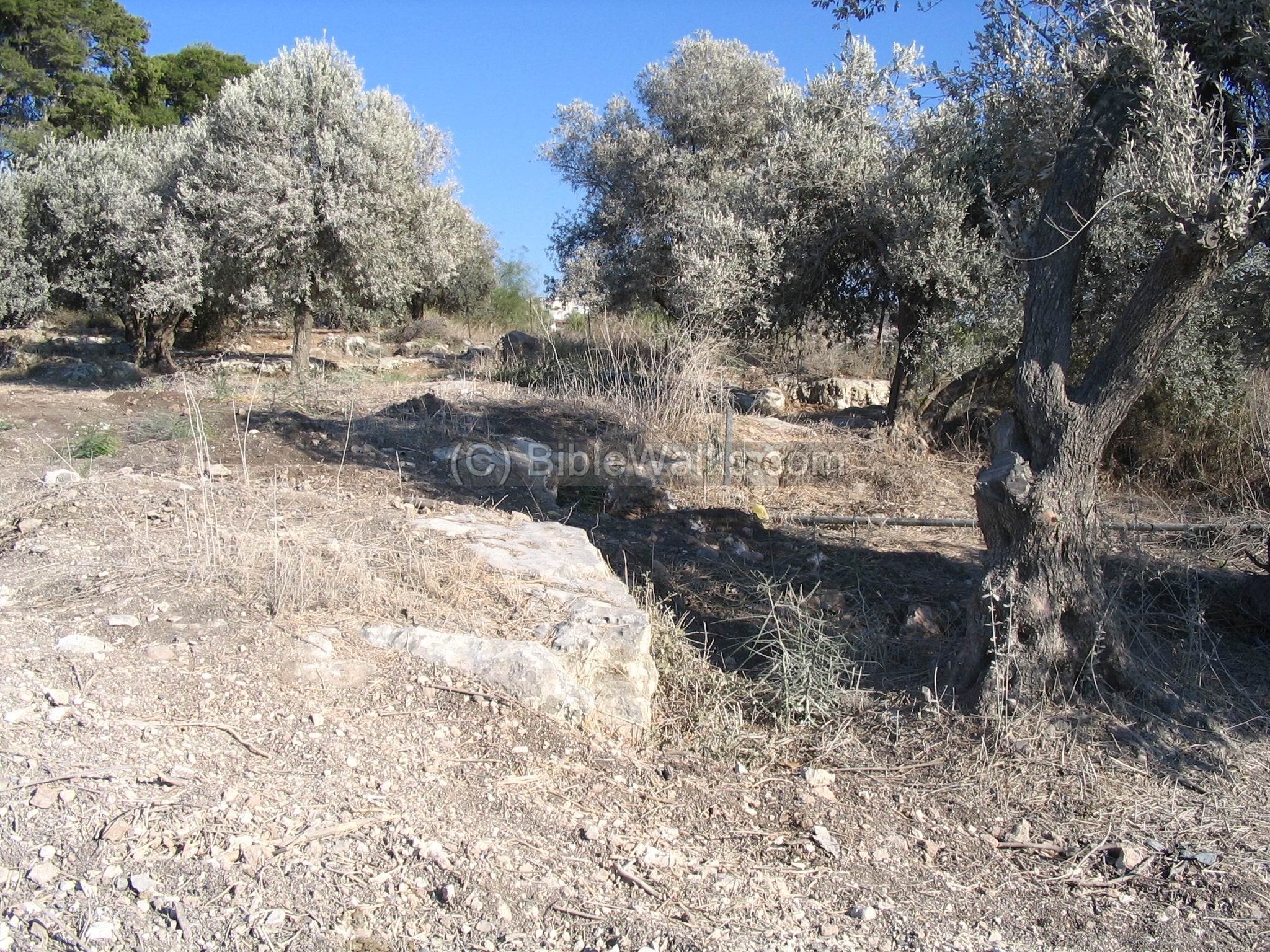
(b) Khirbet Ibtin:
The newer site (Khirbet Ibtin) is spread over a larger area. The following photo shows the south side, inside a olive tree orchid. To the north of the ancient village there are quarries, rock cut tombs, and stone covered tombs. On the north side there are agriculture terraces. On the west and south slopes of the site there are cisterns and oil/wine presses. According to the survey, the site existed from the Roman to the Ottoman period.
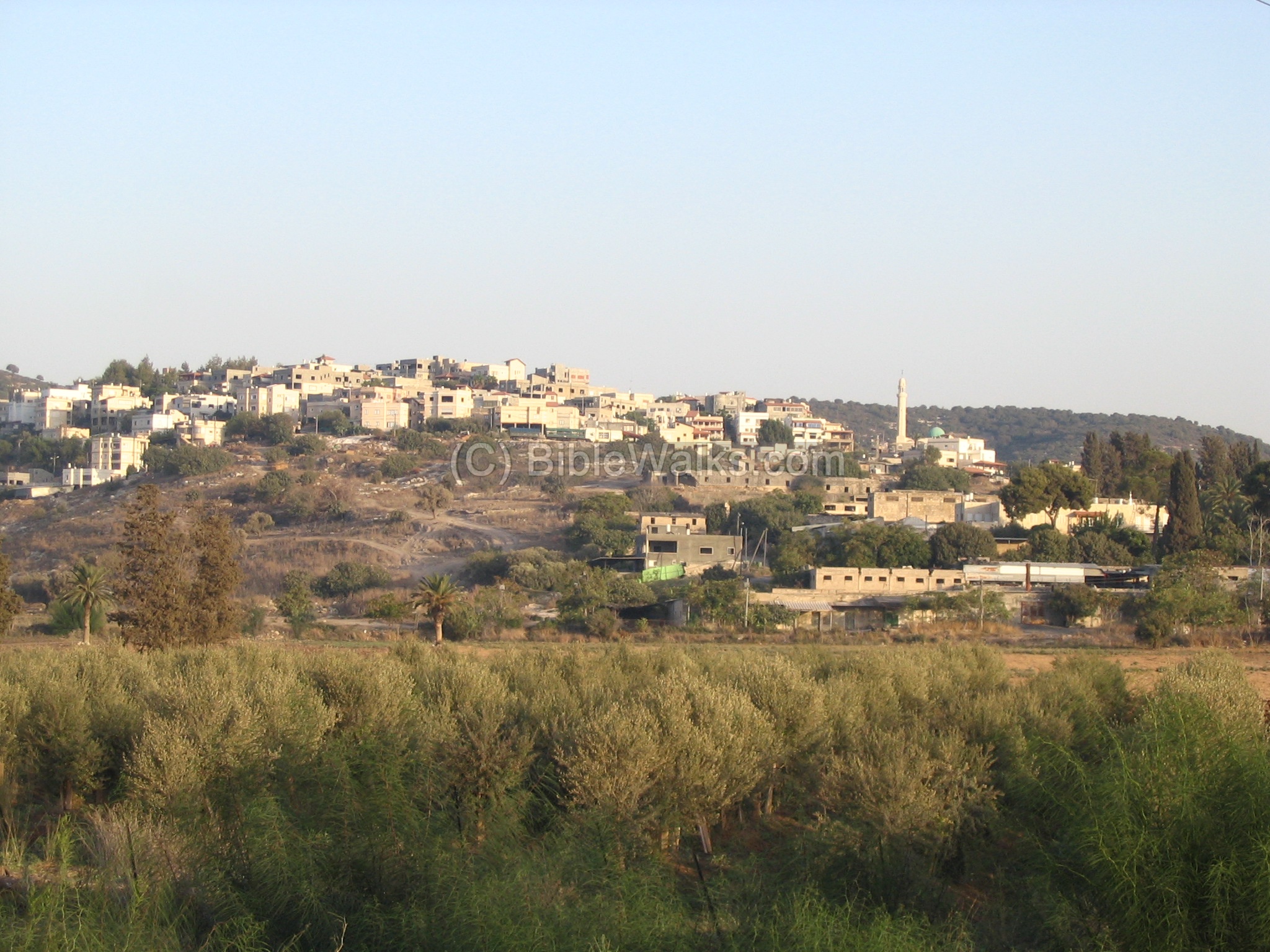
A view from the west. The ancient site is in the center on the lower foothills. The new Bedouin village of Ibtin is on the higher slopes. The bushes in the foreground mark the lowest section where the Zippori creek used to flow towards south, and today there is a modern highway that crosses this place.
(c) Farm and factories:
The Bedouin village of Ibtin is based on a private farm, which was built during the late Ottoman period by one of the richest businessmen – Hadj Tahar Karman.
This rich merchant started as a poor candy peddler, worked with the Turkish army, and purchased land in the Zebulun valley and on the Carmel. He built a large modern farm complex on the western foothills of Ibtin, where his workers resided. During WW1 the Turkish Army used these structures as a base. The ruins of these houses are seen in the photo below.
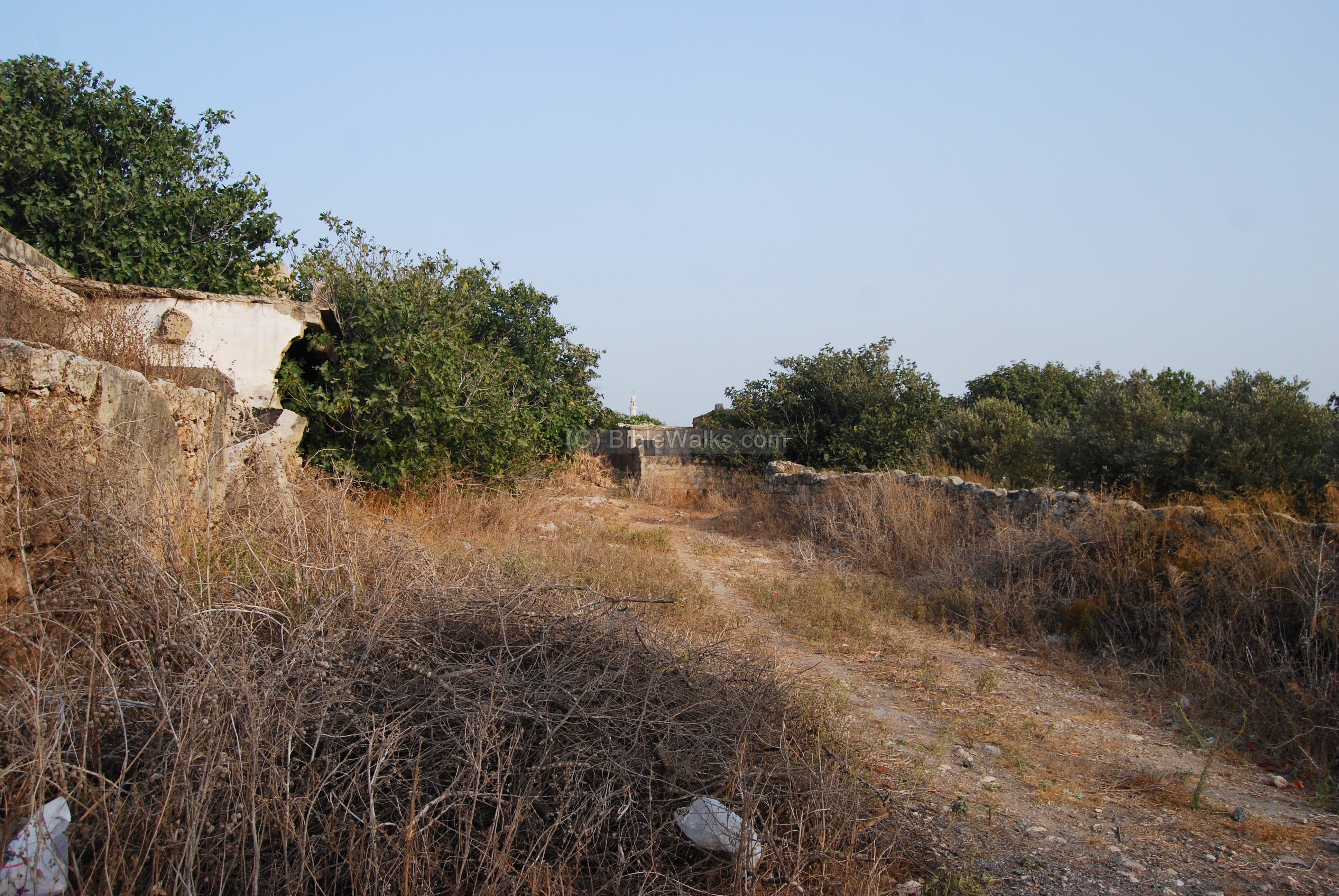
After the the retreat of the Ottoman army (1918), Tahar expanded his business. On this land he built factories that produced tobacco, tehina, flour and more.
The old flour factory, seen below, was seen near the modern road (until around 2009), but then dismantled.

The factories gradually shut down, the farm complex declined, and most of its houses are in ruins. Recently (2009), the owner’s family started selling off some parcels of the farm and new tenants are now moving into some of the old houses.
Biblical References:
(a) Joshua 19:24,25
This text, describing the land of the tribe of Asher, lists the cities in their area. One of the sites, Beten, may relate to Par and Ibtin, since the latter (Ibtin) has a similar name and is listed near Khali which is 3 KM away.
“And the fifth lot came out for the tribe of the children of Asher according to their families. And their border was Helkath, and Khali, and Beten, and Achshaph And Alammelech, and Amad, and Misheal; and reacheth to Carmel westward, and to Shihorlibnath; And turneth toward the sunrising to Bethdagon, and reacheth to Zebulun, and to the valley of Jiphthahel toward the north side of Bethemek, and Neiel, and goeth out to Cabul on the left hand, And Hebron, and Rehob, and Hammon, and Kanah, even unto great Zidon; And then the coast turneth to Ramah, and to the strong city Tyre; and the coast turneth to Hosah; and the outgoings thereof are at the sea from the coast to Achzib: Ummah also, and Aphek, and Rehob: twenty and two cities with their villages”.
Archaeological References:
-
Arch. Survey of Israel – Shefar’am Map (24) – Y. Olami & Z. Gal [1982] , site #111
-
Site Survey by Zvi Gal [1993]
-
Carta’s Atlas of the Bible – Y. Aharoni [Carta Jerusalem 1974]
Maps: 72 (Asher tribe region), 113 (Solomon’s Kingdom)
Etymology (behind the name):
-
Par – was renamed in Hebrew (means bull) after the Arabic name (Far)
-
Ibtin – unknown name, but may have preserved the ancient site name of Beten (Hebrew: stomach). It was also named in the PEF map as Abtun (meaning: a private name).
-
Tell – Mound in Hebrew and Arabic
-
Khirbet – ruins in Arabic. In Hebrew – the root name (Kharav) means ruin.
-
Name in the survey of Western Palestine (1881): Tell el Far
Links:
Visit the following sites, which are around this site:
- Nahal Zippori (Sepphoris creek)
- Khali – a number of ancient sites 3 KM north, located in N. Zippori valley
- Tel Regev which is located 2KM south of this site, and was the major city in the area
BibleWalks.com – walk with us through the sites of the Holy Land
Tel Regev <<<–previous site—<<<All Sites>>>next West Galilee site —>>> Khirbet Sharata
This page was last updated on Apr 28, 2024 (update Biblical map, add PEF map)
Sponsored links: