The city of Akko (Acco, Acre) original site during the Biblical times was several kilometer east of the old city of Acre. The site, Tel (mound) of Akko, was one of the important port cities in the ancient world, situated on the northern gate to Israel.
Home > Sites > Acre> Tel Akko (Biblical Acco, Tell el Fukhar)
Contents:
Overview
Location
History
City Plan
Photos
* Aerial view
* South
* North
* NorthWest
* Ceramics survey
* Aerial Video
Biblical
Etymology
Links
Overview:
The Biblical city of Akko (Acre) is located east to the old city, and located on a large Tel (Mound, Heap) east of the old city, on the north bank of the Na’aman (Belus) river. The city , established in the Bronze period, was part of the region of Asher:
Judges 1: 31: “Asher drove not out the inhabitants of Acco…”
The mound was abandoned in the late Hellenistic period, when the new city moved closer to the sea. The hill was reused in later periods for brief times, such as being a base for the sieges of the Crusaders (1099) and Napoleon’s Army (1799).
Today, the site is in ruins. The neighborhoods of the modern city of Akko are located to the east and north of the Tel. On the western foothills is the city’s soccer field.
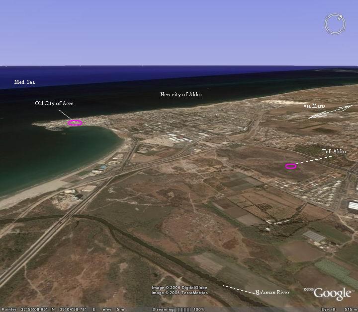
Location:
Akko (Acre) is located at the North of Israel, on the shores of the bay of Haifa. The Tel is located on the east side of the old city of Acre, as indicated on this map. In the Biblical times the Na’aman river, far away to the south, used to be closer to the Tel, but its natural flow was diverted to the south at modern times.
An aerial map of the area of Tel Akko is shown below, indicating the major points of interest.
History of the place:
- Establishment of the city
Akko was first inhabited during the early Bronze period (3rd Millennium BC) and reached its peak at the Middle Bronze age (18th-16th century BC). It continued to function as one of the major cities in the region until the late Hellenistic period (2nd century BC).
- History highlights of Tel Akko:
| 16th_century_BC | Mentioned as “Aak” of the tribute-lists of Egyptian Pharaoh Thutmoses III | |
| 14th century BC | Mentioned in the Amarna letters, a 14th century BC Egyptian archive of clay tablets | |
| 8-6th century BC | Major port for the Phoenicians (from Sidon); city named “Ace” | |
| 701 BC | Assyrian Sennacherib intrusion into Israel – stops in Akko | |
| 6th -4th century BC | Persians conquer the city and expand it to the west; Phoenicians control under Persian rule | |
| 332BC | Greek rule starts: Alexander the Great takes control | |
| 2nd century BC | The city relocates west; the city on the Tel declines and is abandoned | |
| 1190 AD | Crusaders used the hill as a base during the siege on the Arabs in Acre | |
| 1799 | Napoleon’s 9-weeks siege on the City against the Ottomans and a British warship; the siege failed and Napoleon retreated back to Egypt | |
| 17.5.1948 | During the independence war, Israel forces bombarded the Arab city from the hill |
Ancient Roads:
Tel Akko was located on a prime location – it stood on the northern part of Via Maris, the major ancient North-South road. Another road lead from Akko towards south-east, then east to the sea of Galilee and Syria. The city was a gateway on these important cross roads, which at those times were the important trade routes.
A Biblical map shows the routes that converged at Tel Acco, connecting the north to the south and east. Acco is in the center of this section of the north-west part of Israel.
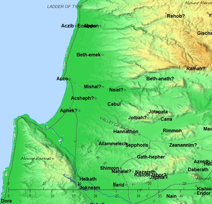
Roads and cities during the Canaanite/Israelite periods thru the Roman period (based on Bible Mapper 3.0)
Plan of the ancient city:
The mound is 600m long and 350m wide, covering an area of 200 dunams (20 hectares). It was protected by its great walls and high ramparts. Sections of the city were excavated in a dozen of archaeologic areas along the circumference and in some areas around the mound, revealing the might of the Bronze/Iron age city.
The main city gate, named “Sea Gate”, is on the north western side (see illustration). It was unearthed in “Area F”. On the higher northern part of the mound was the “Acropolis”, excavated in areas “A-AB”. The Na’aman river flowed along the southern and eastern foothills to the sea on the west (left side).
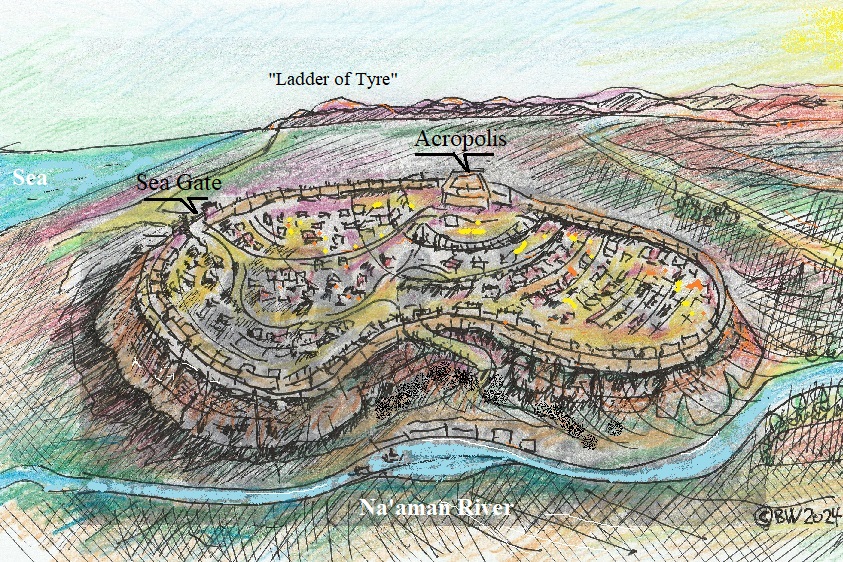
Figurative illustration of Bronze age City [by BibleWalks]
The current shape of the mound is like a banana, with a curve in the southern eastern side. Compared to a common plan of a full oval shaped Biblical mound, Tel Akko has a deep cut with a quarter (!) of the ground missing. Indeed, there were earth works conducted during the British mandate period in order to drain the swamps of the Naaman river, and other damages that were caused over the years. However, these could not explain the extensive change in the shape.
Initially it was proposed that this curve was built around a sea port. The archaeologists, M. Artzy and J. Quartermaine, attempted to research the history of this unique shape. Reviewing multiple old photos and reports (links), the archaeologists concluded that this shape might have been the same in the Bronze/Iron age, although the mound suffered from extensive changes over the thousands of years.
Furthermore, they are not certain if the fortifications encircled the entire circumference of the mound or were limited to part of it. The ancient ramparts have changed during the various phases of construction.
Strength of the ancient city:
The ancient city defense was based on its heights, its walls and ramparts. It was also strengthened by the marshes of the Na’aman (Belus) river, flowing at the south and east of the Tel. According to the archaeological surveys, evidence indicates that seawater was used to encircle the city from 3 sides (east, south and west).
The city was so strong that the Israelites failed to capture it, as written in the Bible (Judges 1):
“Asher drove not out the inhabitants of Acco”.
The Tel was located at the mouth of the river, which gave it its most important asset: a natural harbor for the port city. The sea-trade in the ancient times made the city prosperous. With these two assets, maritime and land trade, the city rose to be one of the strongest and important cities in the Biblical Israel.
Photos:
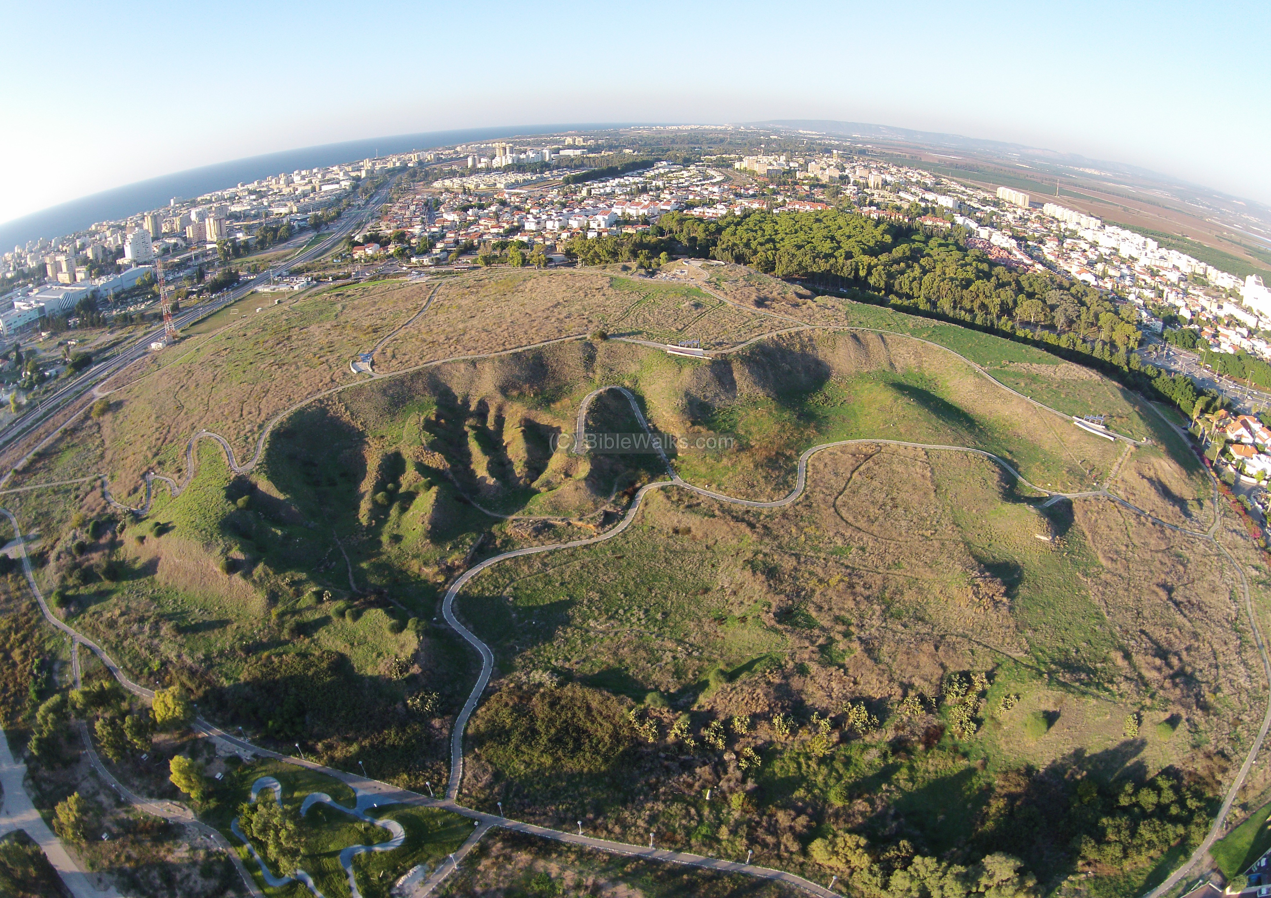
(a) Aerial view:
A drone captured this photo from the south side of Tel Akko. The modern suburbs of Akko are seen around the mound. The old city of Acre, with the Crusaders and Roman history, are located outside of this field of view on a peninsula west of this mound.
Click on the photo to view it in higher resolution…
![]() Fly over the site and view its surroundings with the following YouTube video:
Fly over the site and view its surroundings with the following YouTube video:
(b) South side of the mound:
This photo shows a section on the south side of the hill, which faces the Na’aman river. The hill side is potted with ancient ceramics, cisterns, traces of walls, archaeological excavations, and a layer of dirt that accumulated over the years.
The next photo is another view of the Tel from the south. Most of the area in this southern section was quarried and hallowed out in 1942, since it was used to dry out the marshy lands area south of the Tel.
In the Bronze period the whole city had a very high rampart, impressive walls and gates. Some traces of these fortifications can still be seen here today, and especially in the northern and western sections.
The shape of the mound is like a banana, with a curve in the southern eastern side, as seen here in this view from the south..
A long line of Kurkar sandstone is seen at the bottom side.
During antiquity the sea shore reached to this side of the mound at the mouth of the Naaman river. This may have been an ancient pier .
(c) North side:
There are few noticeable remains on top of the mound. However, excavations in this section on the north side of the mound revealed that this was the main section of the ancient city – the “higher city”.
In the following photo, which was taken on the north side of the Tel, you can see how high the hill is above the road. The ancient city lies below the Tel, which is composed of many layers of previously destroyed cities, and a set of impressive walls and fortifications from the Canaanite/Bronze period.
On top of the hill is a statue of Napoleon, who tried in 1799 to capture the old city of Acre and may have used the ancient hill as one of the French Army’s bases. This short (9 weeks) chapter in history gave its name – Napoleon’s hill.
A closer view of the statue:
The excavated areas A-B were covered by weed during our visit in May 2024. The area is adjacent to the status on its west side.
The excavations on this part, within areas ‘A’ and ‘B’, revealed a massive city wall dated to the Middle Bronze II period. The city wall probably encompassed the entire city, although only sections of it were unearthed along the peripheral of the mound. The wall was composed of 2 sections:
- a lower cyclopean wall 3.5m wide, built of massive limestone fieldstones,
- a wall above it, 2.5m wide, built with an external plastered mud brick wall and ramparts laid behind it. The wall was built with offset-inset pattern.
- Towers were built above the wall
A fortress was built at a later stage on the acropolis (area ‘A’), at the end of the Middle Bronze IIa (2000-1750 BC). It was 9m wide and 14m long, and had 2 floors. A staircase with 19 steps led to the upper floor.
During the Middle Bronze IIb-c (1750-1550) the settlement on the mound reduced in size and concentrated only on the acropolis. It grew again during the Late Bronze I (1550-1300 BC). A layer of ash indicated that the city was burnt at the end of this period.
At a later stage (Late Bronze II, 1300-1200 BC) the fortress in area ‘A’ was destroyed, probably during the reign of Seti I or his son Ramasses II who conquered Canaan. The fortress was covered by a rampart, and farming installations were built around it.
(d) North West side
A quadcopter photo shows the top of the mound from its north west side looking towards south. Crisscrossing the site are walking trails. In the far right background is the bay of Akko.
On this side, in excavation area ‘F’, the archaeologists unearthed the city gate, dated to the Middle Bronze IIa (2000-1750 BC). It was named the “Sea Gate” as it faces the sea. The gate was incorporated in the city wall, and was oriented NW-SE.
A closer view of the “Sea Gate” is shown below, with the excavated gate.
The gate was 20m in length and composed of 2 units: the outer part (NW) was built with 2 parallel walls made of large boulders, while the inner part (SE) was a thick high wall constructed of bricks. Its structure is similar to the Canaanite gates in Tel Ashkelon and Tel Dan.
The gate was in use until the Late Bronze period, then covered by new ramparts. This cover saved the gate for 3000 years until it was unearthed and preserved to its original form.
The original brick walls are protected by a wooden shell, and the steps leading thru the gate were covered by wooden steps.
(e) Ceramic Survey
During a short survey of the mound I noticed a large pile of dirt that was arranged on the foothill, with dozens of ceramic fragments. Here is a sample of the pottery fragments that were collected. All of the ceramics were left at that spot.
The following are the largest items. They were identified as vessels dated to the Persian period. During this time the settlement on the mound expanded after a low period of the Babylonian period.
1:
2:
3:
(f) Aerial views
![]() An aerial view video of Tel Akko can be seen in the following Youtube video.
An aerial view video of Tel Akko can be seen in the following Youtube video.
Biblical References:
(a) Joshua 19:24, 29:30
This text, describing the land of the tribe of Asher, lists the cities in the Tribe’s area. The city Ummah may refer actually to Acco, according to some scholars, since it is listed after Achzib and before Afek, a sequence that may imply the city of Acco. Ummah may be the Jewish name of the Canaanite city.
24 “And the fifth lot came out for the tribe of the children of Asher according to their families.
…
29 And then the coast turneth to Ramah, and to the strong city Tyre; and the coast turneth to Hosah; and the outgoings thereof are at the sea from the coast to Achzib:
30 Ummah also, and Aphek, and Rehob: twenty and two cities with their villages”.
(b) Judges 1: 31
This is the only reference of Acco (Akko, Acre) in the Old Testament. In the story of the conquest of the Land by the Israelites, the Bible writes about cities, including Acco, that the the tribe of Asher did not succeed to drive out the Canaanites, due to its strong fortifications. It remained linked to the cities of Sidon (Zidon) and Tyre (actually, for 3000 years).
“Asher drove not out the inhabitants of Acco, nor the inhabitants of Zidon, nor of Ahlab, nor of Achzib, nor of Helbah, nor of Aphik, nor of Rehob;”
Etymology (behind the name):
- Tel (Tell) – mound (See more on the story of a Tel).
- Ace – Phoenician name
- Akko – Biblical name
- Tell el Fukhar – Arabic name of the mound, meaning: “The mound of the sherds”.
Archaeological References and Links:
- Prof M. Dothan – excavated the site during the 70s and 80s;
see: Dothan M. 1976. Akko: Interim Excavation Report First Season, 1973/4. BASOR 224:1–48.
- “The new encyclopedia of archaeological excavations in the Holy Land” [1992 E. Stern editor, Hebrew, Volume 3 pp. 1224-1230]
- Tel Akko excavations 2010-2019 – Preliminary report [A. E. Killebrew, J. C. Skinner and M. Artzy; HASEI V 135 2023] – renewed excavations in area A on the northern section of the mound
- Tel Akko – Topographic Survey Report – Lancaster University Archaeological Unit (pdf; 1999) – contour maps
- How and when did Tel Akko get its unsual banana shape? Archaeopress, pp 11-22, Michal Artzy and Jamie Quartermaine; Great article!
- Tel Akko Sea Gate – Moshe Dothan, Avner Raban, 1980
* Internal links:
- Quadcopter Aerial views – collection of Biblical sites from the air
BibleWalks.com – walk with us through the sites of the Holy Land
Acre (overview)<<<–previous site—<<<All Sites>>>–-next Acre site –>>> Khan al-Umdan
This page was last updated on May 30, 2024 (pottery dating)
Sponsored links: