Beit Shean was a major Biblical city, located in the center of major trade routes. The Hellenistic city, Scythopolis, was established near its ruins and became a major city until its destruction in the 8th century.
Home > Sites > Yizreel Valley > Beit She’an – Scythopolis (Overview)
Contents:
Background
Location
History
Photos
* Aerial Views
* General view
* Palladius
* West bathhouse
* Sigma
* Tel
* Nympheon
* Theater
* Amphitheater
* Tel Iztabba
* Crusaders
* Night show
Biblical References
Etymology
Links
Background:
Tel Beit Shean (Beth She’an) was a major Biblical city, located in the center of crossroads between the Jordan valley and the Jezreel (Yizreel) valley.
1 Kings 4 7-12: “And Solomon had twelve officers over all Israel… Baana the son of Ahilud; to him pertained … all Bethshean, which is by Zartanah beneath Jezreel”
It later was expanded into a large Hellenistic, Roman and Byzantine city of Scythopolis, south and east of the ancient mound. The large city was leveled by a massive earthquake in the 8th century AD, and was in ruins until recent archaeological excavations which are unearthing and reconstructing this amazing city.
Location:
The national park is located on the north side of the modern city of Beit Shean (Beth She’an), which is located on the south-east corner of the Galilee. It is located south to the Harod creek which flows from the foothills of the Gilboa mountain. The site is close to the Jordan river, which flows 5KM to the east of the site.
An aerial map of the ruins of Beit Shean is shown below, with the north side on the top of the photo, indicating the major points of interest.

History:
-
Prehistory
Excavations dated the earlier findings in the area to the Calcolithic period (about 45 century BC). The early man dwelt in the caves around the site, cultivating the fertile area around the site with an abundance of water.
According to the excavations, the city was established in the Early Bronze age II (early 3rd Millennium). It extended to the hill east of the Tel, and became a large town. It is located on a prime location – in the center of major ancient crossroads (North-South connected Asia Minor to Egypt, and West-East connected the sea to Jordan and Arabia). The city is referenced in several Egyptian sources, starting in the 19th century Egyptian (12th Dynasty) enemy-curse clay tablets as “Aphkm”.
After it was destroyed by fire, it declined into a small Middle Bronze age town (19th-15th century BC) .
-
Canaanite/Egyptian city
The city is listed as one of the cities that were conquered by Egyptian Pharaoh Thutmose III , just after the famous battle near Megiddo (1468 BC), which resulted in the Egyptian conquest of Canaan for 350 years. The excavations in the city unearthed findings from the period of Thutmose III.
During the late Bronze period and the beginning of the Iron age (15th century to 12th century BC) the city became as a center of the Egyptian imperial administration in northern Canaan, as did Megiddo.
A basalt tablet from Seti I (~1294-1279 BC) was found in the city with the name of Beit-Shean. The name of the Holy Land in this tablet is “Retenu”, which was the Egyptian name of the land of Israel before the Israelite conquest.
The city is also mentioned in the Amarna letters, a 14th century BC Egyptian archive of clay tablets.
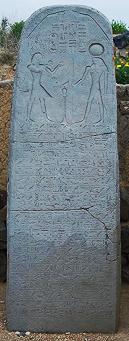
Seti I Stele found in Beit She’an
-
Biblical times – Beit Shean
The mighty Canaanite city was not conquered by the Israelites (Judges 1: 27: “Neither did Manasseh drive out the inhabitants of Bethshean and her towns”). Later, in the 11th century BC, King Saul’s body was displayed on its walls after his defeat by the Philistines (1 Samuel 31 10: “…and they fastened his body to the wall of Bethshan”).
The Canaanite/Philistine city was burnt in the 10th century by King David. His son, King Solomon, rebuilt it and made it an important administration city (1 Kings 4 7-12: “And Solomon had twelve officers over all Israel… Baana the son of Ahilud; to him pertained Taanach and Megiddo, and all Bethshean, which is by Zartanah beneath Jezreel“.
After Solomon’s death, Egypt’s Shishak invaded Israel in 924 BC (1 Kings 14: 25: “in the fifth year of King Rehoboam, Shishak king of Egypt attacked Jerusalem”). According to the Pharaoh’s hieroglyphic inscriptions, Beit Shean is listed as one of the cities that he captured and Beit Shean’s governor is illustrated as led to captivity in Egypt.
The Assyrians captured the Galilee (732 BC), and destroyed Beit Shean to its foundations.
-
Hellenistic period – Nisan-Scythopolis
During the 3rd century BC the city was rebuilt on the top of the Tel and to the north of it. The city was renamed Scythopolis and Scython-Polis, named after the veterans who resettled the Hellenistic city in 633 BC. According to Greek mythology the city was founded by the wine God Dionysos who lived in the city. According to the legend, his nursemaid Nysa who breast-fed him was buried in the city, so it was named Nysa-Scythopolis or Nisa.
The city was an important Greek Polis in the 2nd century BC, but destroyed by the Hasmonaens in about 100 BC. According to the Historian Josephus Flavius (Wars 1 2 3-7): “John, who was also called Hyrcanus … marched with an army as far as Scythopolis, and made an incursion upon it, and laid waste all the country that lay within Mount Carmel”. This description shows that the city was a key to the Galilee region, and after its conquest the whole area was under the control of the Jewish Kings.
-
Roman period – Skythopolis is a major city
During the Roman period, starting in the 1st century BC, the city became an administration center, and was part of the Decapolis – the league of the 10 cities which were located in a region east of the Jordan river and and north of the city.
A new well planned city was established to the south and east of the ancient Tel. The new urban design included wide colonnaded paved streets that crossed the civic center at the foothills of the ancient Tel. Large public structures, shopping areas and residential areas were constructed, and the city became one of the most important cities in the region.
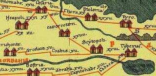
The city is seen in the Peutinger map (Peutingeriana tabula) of the 4th century Imperial Roman roads as “Scytopoli”, a major city which was connected via a road along the Jordan river to Jericho (on the left “Herichonte”), north to Tiberias (Tyberias” on the right) and south-west to Caperconti (Legion near Megiddo) and then to Caesarea Maritama (“Cesaria”).
After a major earthquake that affected most of the Galilee (363 AD), Scythopolis was damaged, but was reconstructed and rebuilt and continued to grow.
-
Byzantine period – prosperous Christian city
During the 4th-7th century the city continued to prosper, but the pagan structures were converted to other uses since the majority of the population was Christian. The size of the city grew to 400 Acres, expanding to all directions, including Tel Iztabba north of Nahal Harod river. Its population grew to 40,000 residents, and a 4.5KM long wall was added around the city. In 409, the city was the metropolis (provincial capital) of “Palaestina Secunda”, a region that included the Galilee and northern Trans-Jordan.
-
Arab period – Decline and oblivion
The city was conquered in 635 AD and renamed Beisan, which preserved the ancient name. The city started a decline during this period, although the new rulers were tolerant: the Umayyads of Arabia (661-750) allowed the citizens to continue practice Christianity. However, this ended in a major earthquake which leveled the city in 749AD. The city remained in ruins until modern times.
- Crusaders
The Crusaders arrived from Europe to the Holy Land in order to liberate the Holy Land and free Jerusalem. They accomplished the mission in 1099, and established the Crusader Kingdom. Then they began to construct fortresses along the borders, ports and main roads, and also built fortified towns and farms within the captured area.
Tancred, one of the four leaders of the first Crusade, captured the Galilee and was appointed to be the “Prince of Galilee”, and received its lands including Beisan. The town was administrated by the de Béthune family who settled in Baisan and controlled the town until 1161.
In 1103 the Crusaders built a small rectangular castle east of the Roman city, reusing the stones from the ruins of the Roman city. The fortress served as a fortified administration place, with a visual look out of their fortresses in Belvoir and Mt. Tabor.
Beit Shean during the Crusaders times was a small minor town. After their defeat in 1187 by the Ayyubid forces led by Saladin, the city of Beisan declined further.
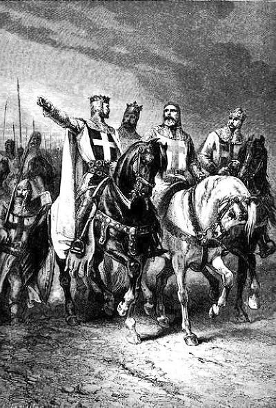
Leaders of the first Crusade – Godfrey de Bouillon, Raymond de Toulouse,
Bohemond de Tarento and Tancred d’Hauteville. – by Gustav Dore (1832-1883)
-
Ottoman/Mamelukes
During the middle ages Beisan was a small village with no importance. In 1308 a large hostel (Khan) was built on the north side, which served trade route from Egypt to Syria. The Crusader fortress was converted by the Mamlukes to a large scale sugar crystallization factory, then reused as a school at the end of the Ottoman period.
Beisan became a larger town after the railroad was laid out close to the village in the beginning of the 20th century.
Conder and Kitchener surveyed this area during the Survey of Western Palestine (SWP), commissioned by the Palestine Exploration Fund (PEF) in 1873. A section of their map is seen here.
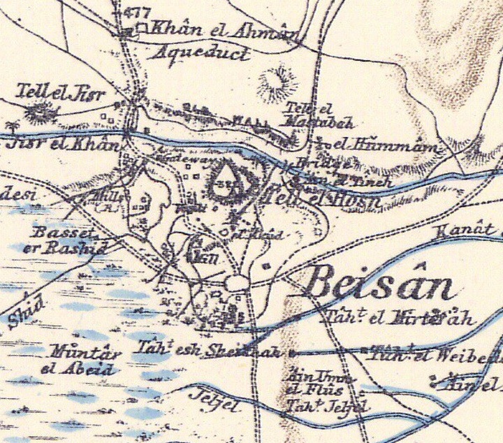
P/O Sheet 9 of SWP, by Conder and Kitchener, 1872-1877.
(Published 1880, reprinted by LifeintheHolyLand.com)
The surveyors also mapped the city and provided the following illustration. The city wall encompasses the entire city, as seen in the map, and crosses the height of the ridge of Tel Iztabba.
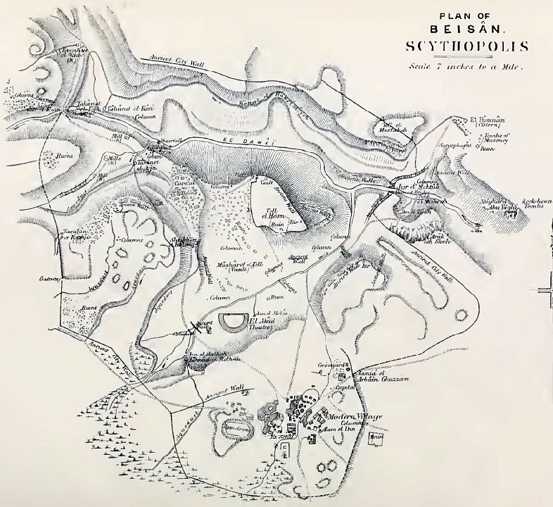
Illustration on p. 104, Volume 2 Sheet 9 of SWP, by Conder and Kitchener, 1872-1877.
-
Modern Times
The new city of Beth-Shean was established in 1949 in the deserted Arab village of Beisan.
In 1949-1957 Noah Merdinger, the first mayor of Beth-Shean, founded the Beth Shean Museum and conducted the digs around the Tel. The Roman theater was excavated in the 1950s (Appelbaom), and major excavations continued in 1983 (Yadin/Geva) and 1989-1996 (A. Mazar). The Tel and the civic center were excavated by Mazor and Bar-Natan, Tsafrir and Foerster. Over 20 layers were excavated in the Tel, attesting to the successive construction of cities one on top of the ruins of the other, spanning more than 2,000 years. (see description of the Tel in our info page). Over 65M$ were invested in the excavations.
The light and sound show was opened in July 2008, with an investment of 3M$ by several government organizations. See more details in our web page.
Photos:
(a) Aerial Views
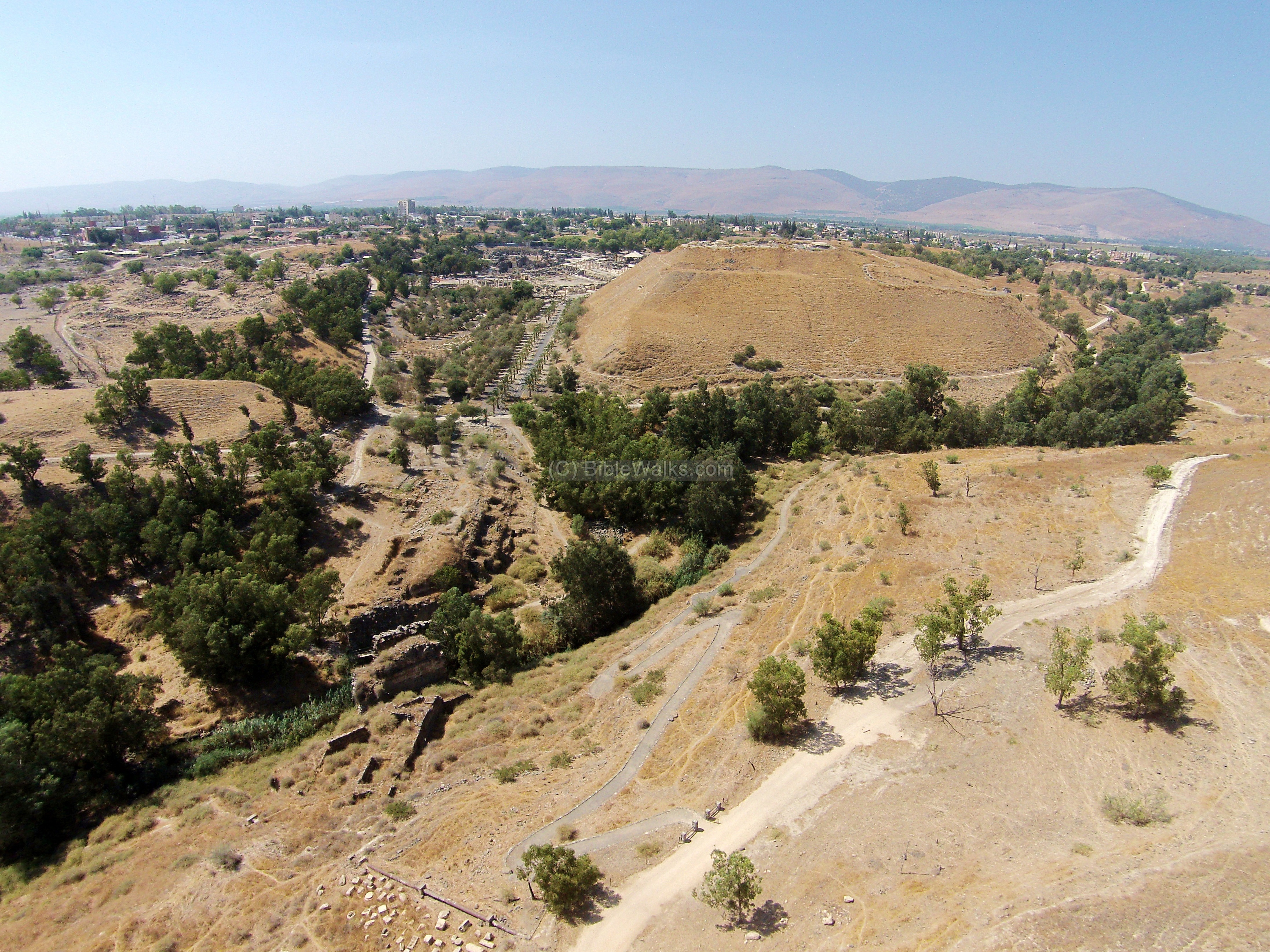
This drone view captured the north east side of Beit Shean. The Biblical Tel is seen behind the valley of the Harod stream. To its left are the ruins of the Roman/Byzantine city, which was accessed from a great bridge seen here on the bottom left side.
Click on the photos to view in higher resolution…
![]() Fly around this point with the following YouTube video:
Fly around this point with the following YouTube video:
(b) General View
A view towards the north is seen in the photo below. The ancient Biblical site is seen in the background, dominating the lower Roman city.
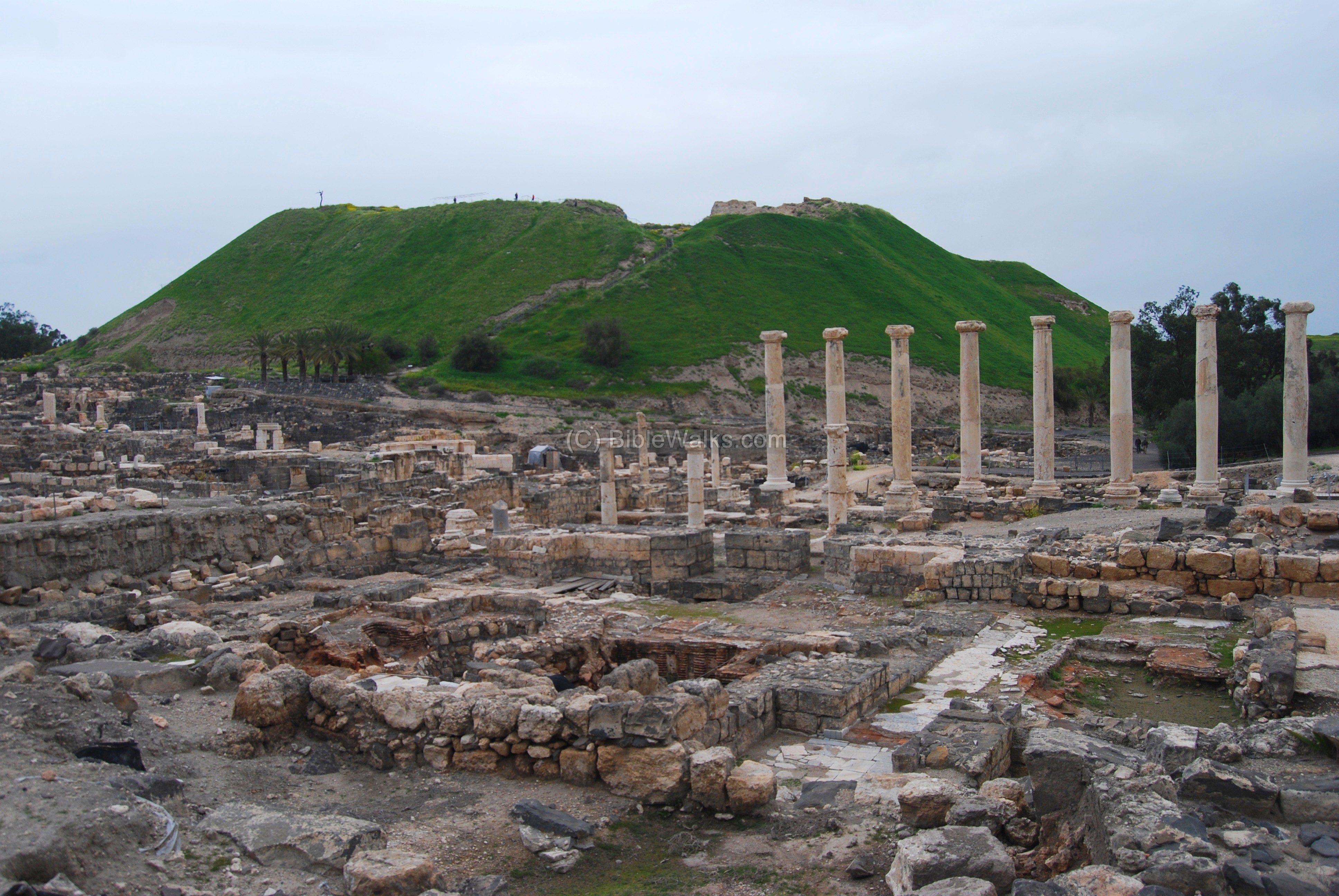
![]() The Biblical Tel is further detailed in a separate web page.
The Biblical Tel is further detailed in a separate web page.
(c) Palladius street
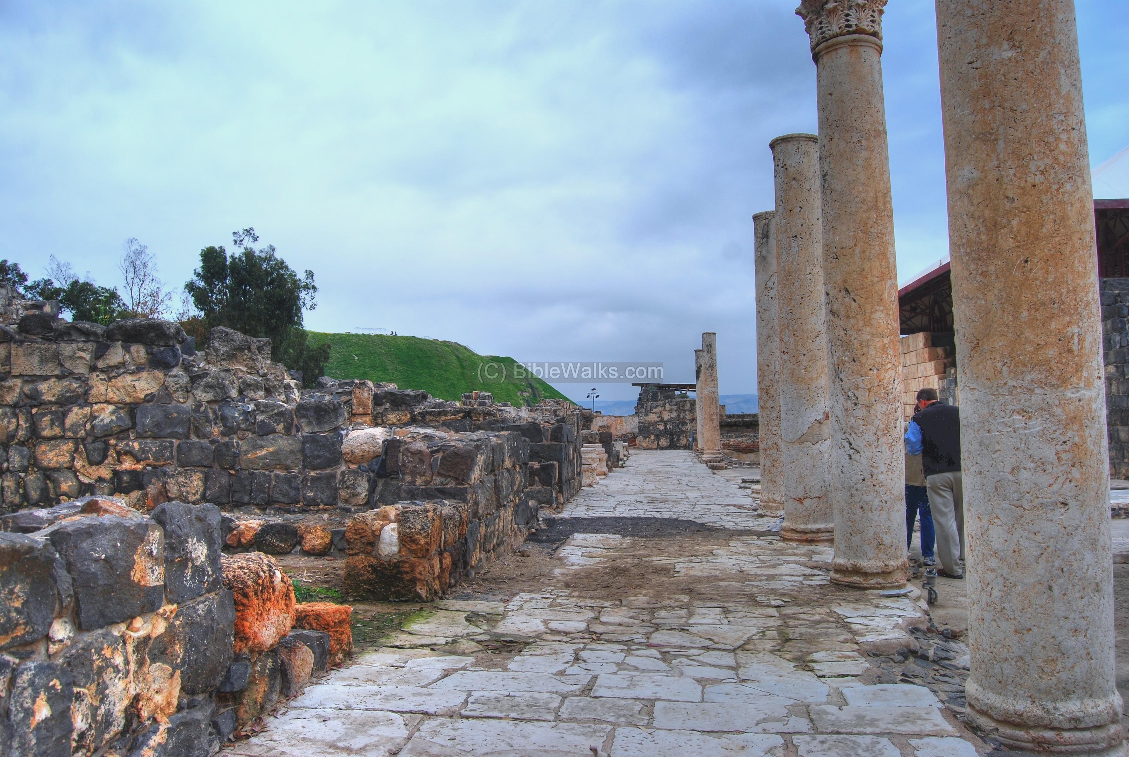
The best view of the Roman city is seen from the top of the Biblical Tel. The photo below shows the Palladius street on the right, stretching towards the south, and the Western bathhouse to its right. The Theater is seen on the far left. In the background is the modern city of Beit Shean, and behind it are the Gilboa Mountains.
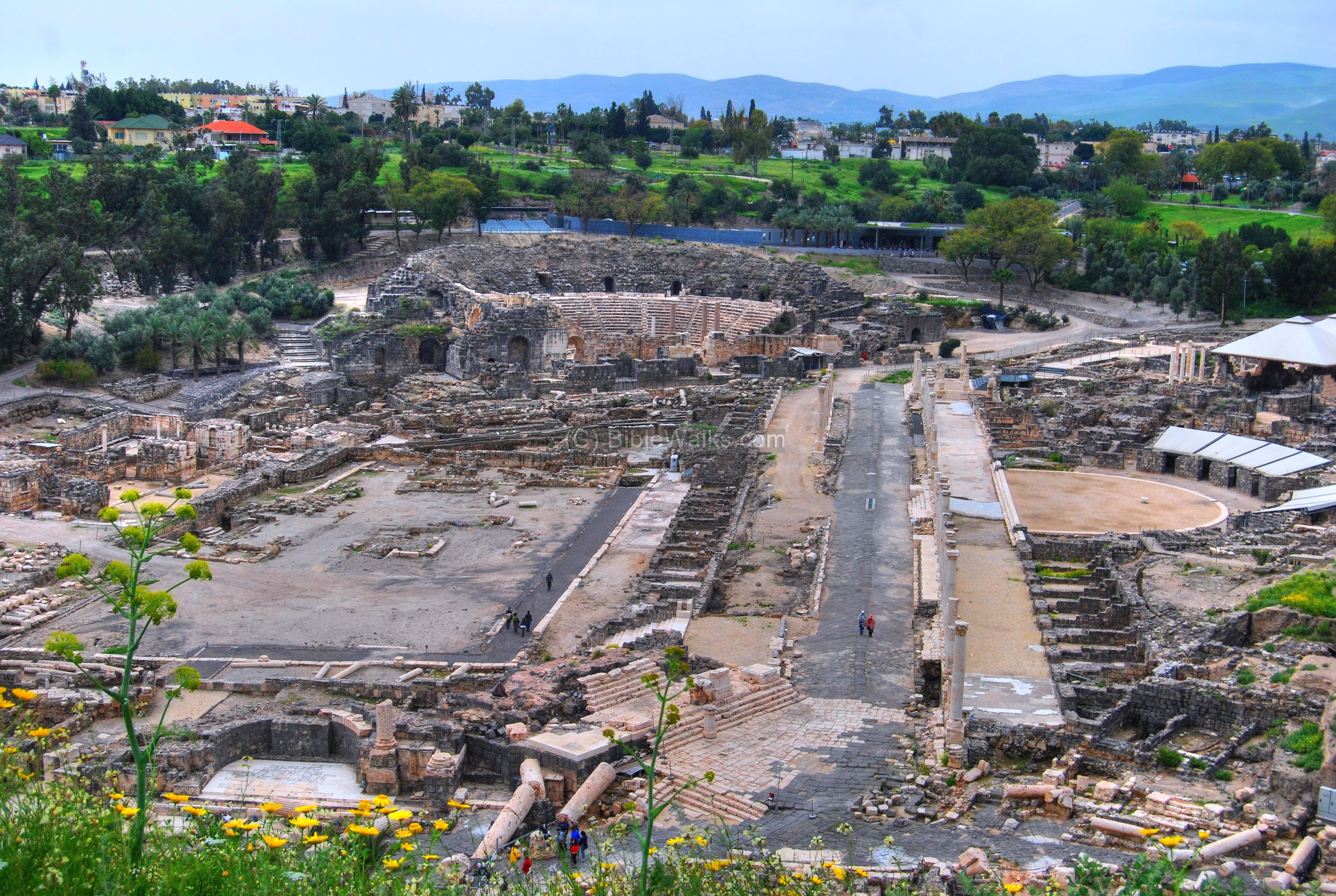
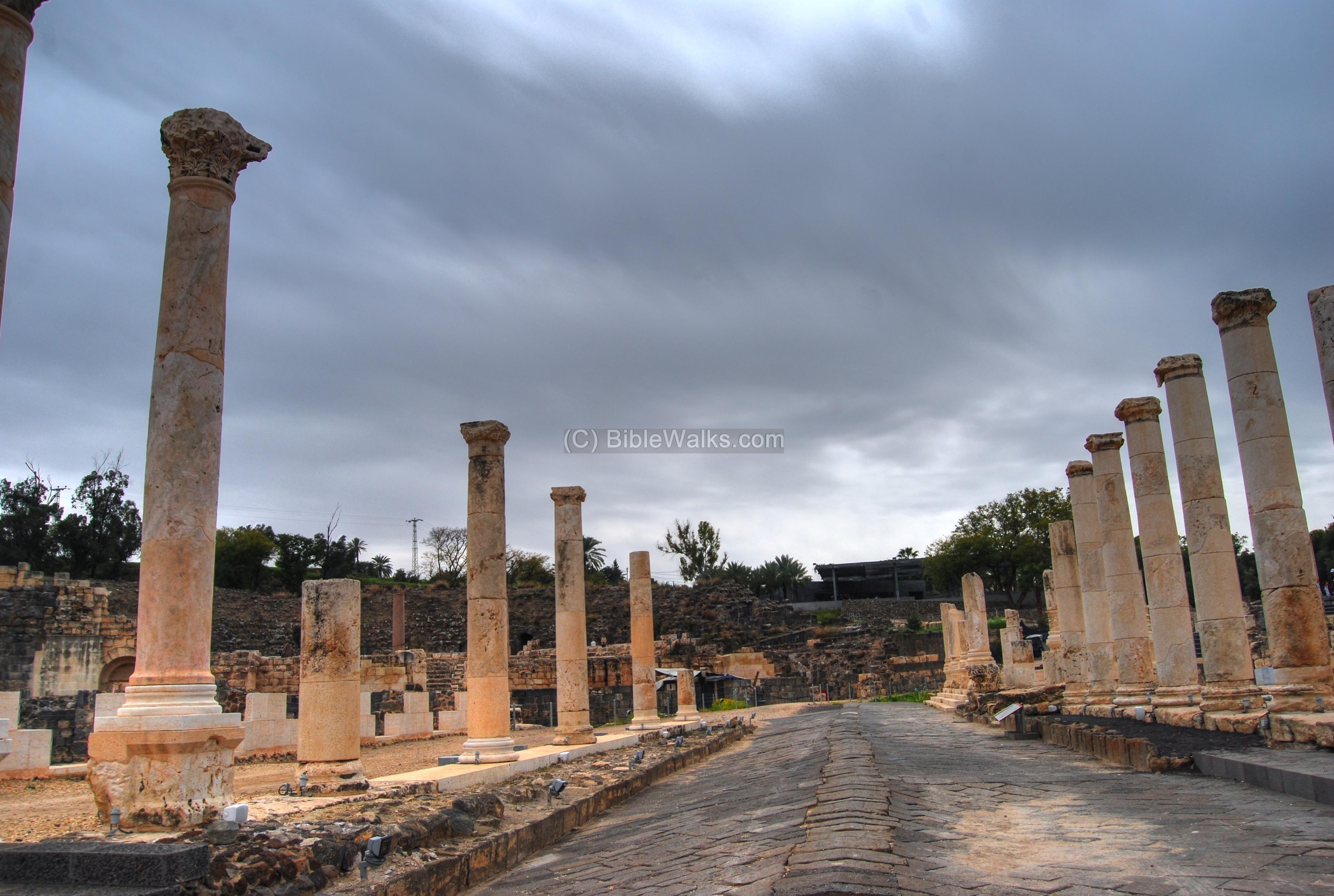
The colonnaded Palladius street extends from the theater to the foothills of the ancient Tel, 150M from south (near the theater) to north (foothills of the hill). The street was built in the Roman period, starting from the 1st century AD, and restored during the Byzantine period. On both sides of the 24M paved street was a raised roofed sidewalk with shops and public houses.
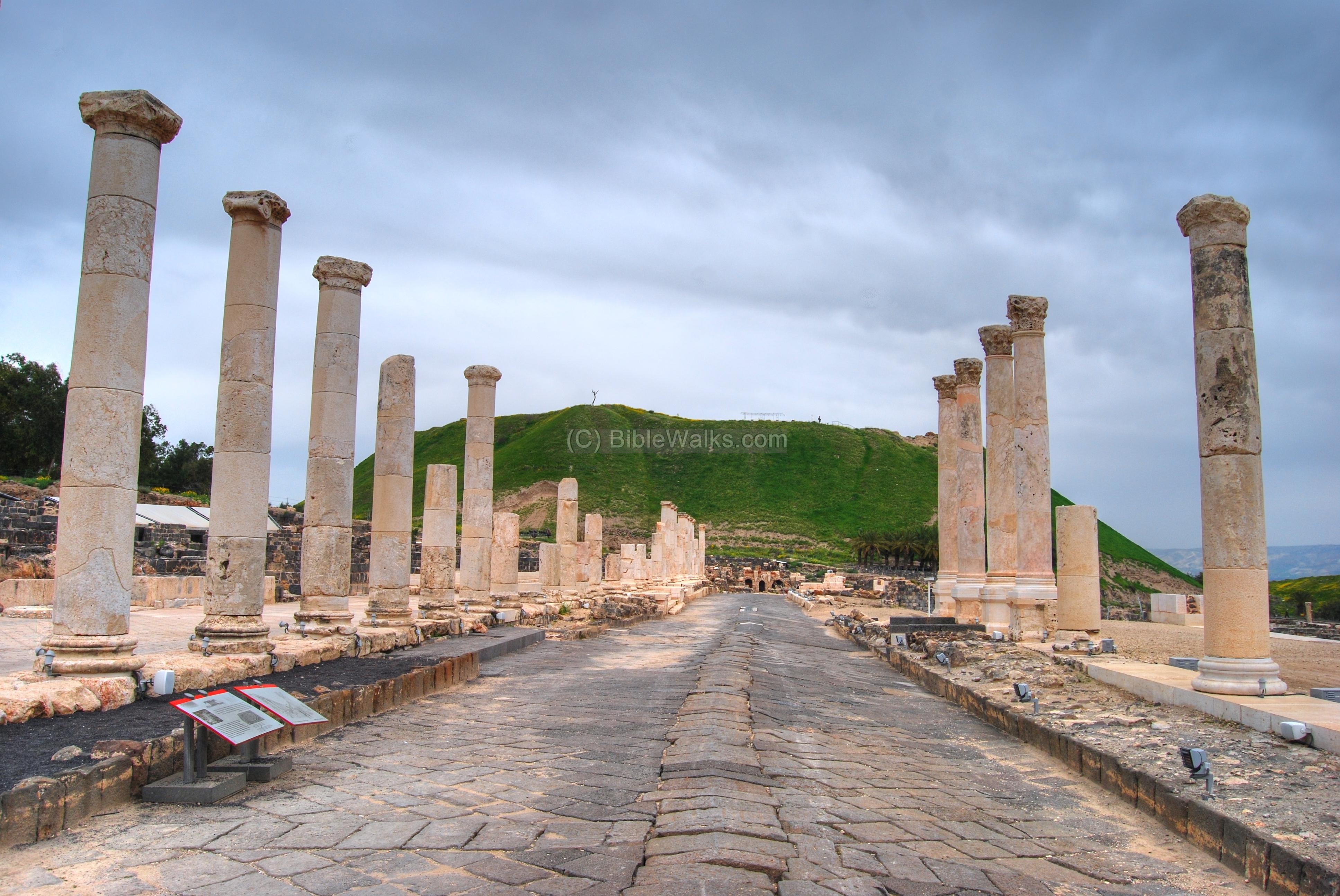
The photo below shows a view of the street toward the south. The name Palladius is based on an inscription found nearby, referring to the 4th century Roman governor.
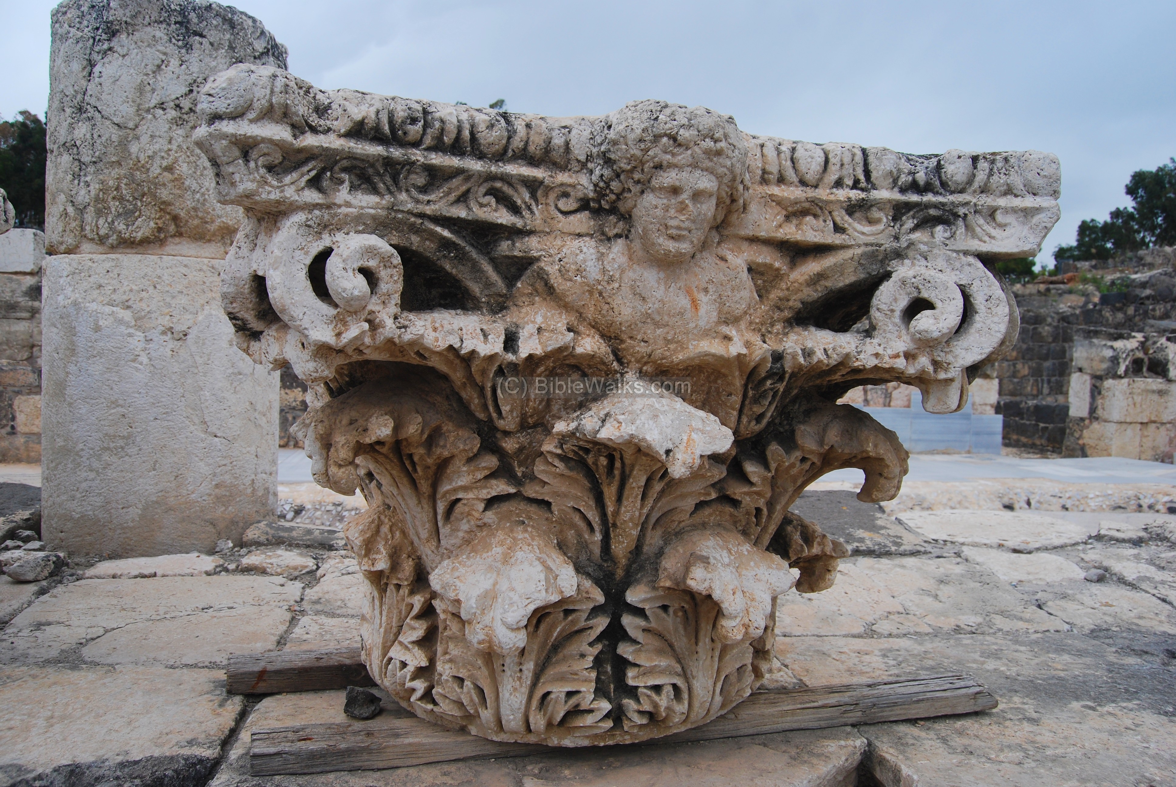
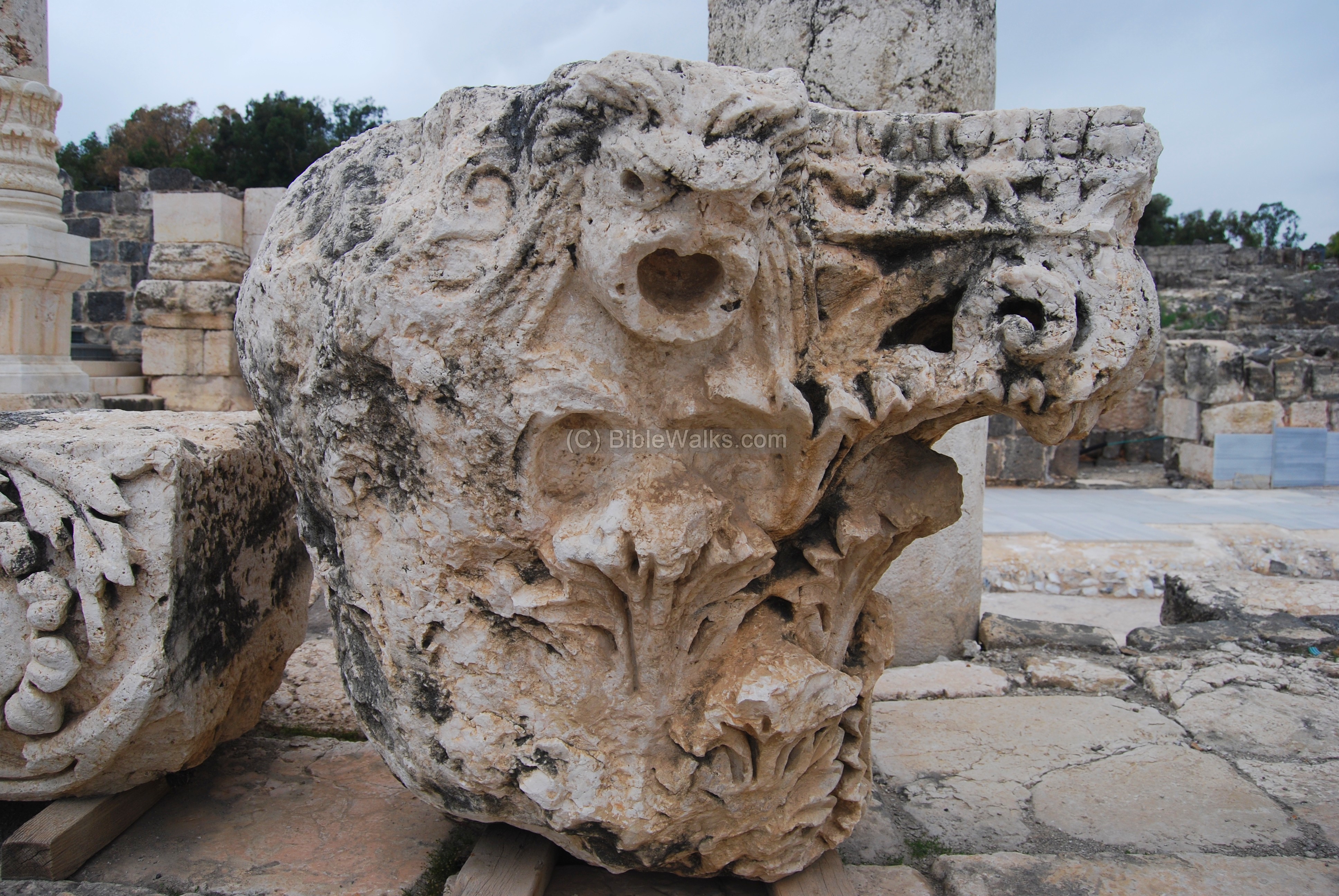
This main street was decorated with statues. Seen below is a Corinthian capital of a pillar, bearing the head of the Greek god Dionysus (Dionysos, also commonly known by his Roman name Bacchus), the god of wine and the patron of the city. According to Greek mythology the city was founded by the wine God Dionysos who lived in the city. According to the legend, his nursemaid Nysa who breast-fed him was buried in the city, so it was named Nysa-Scythopolis or Nisa.
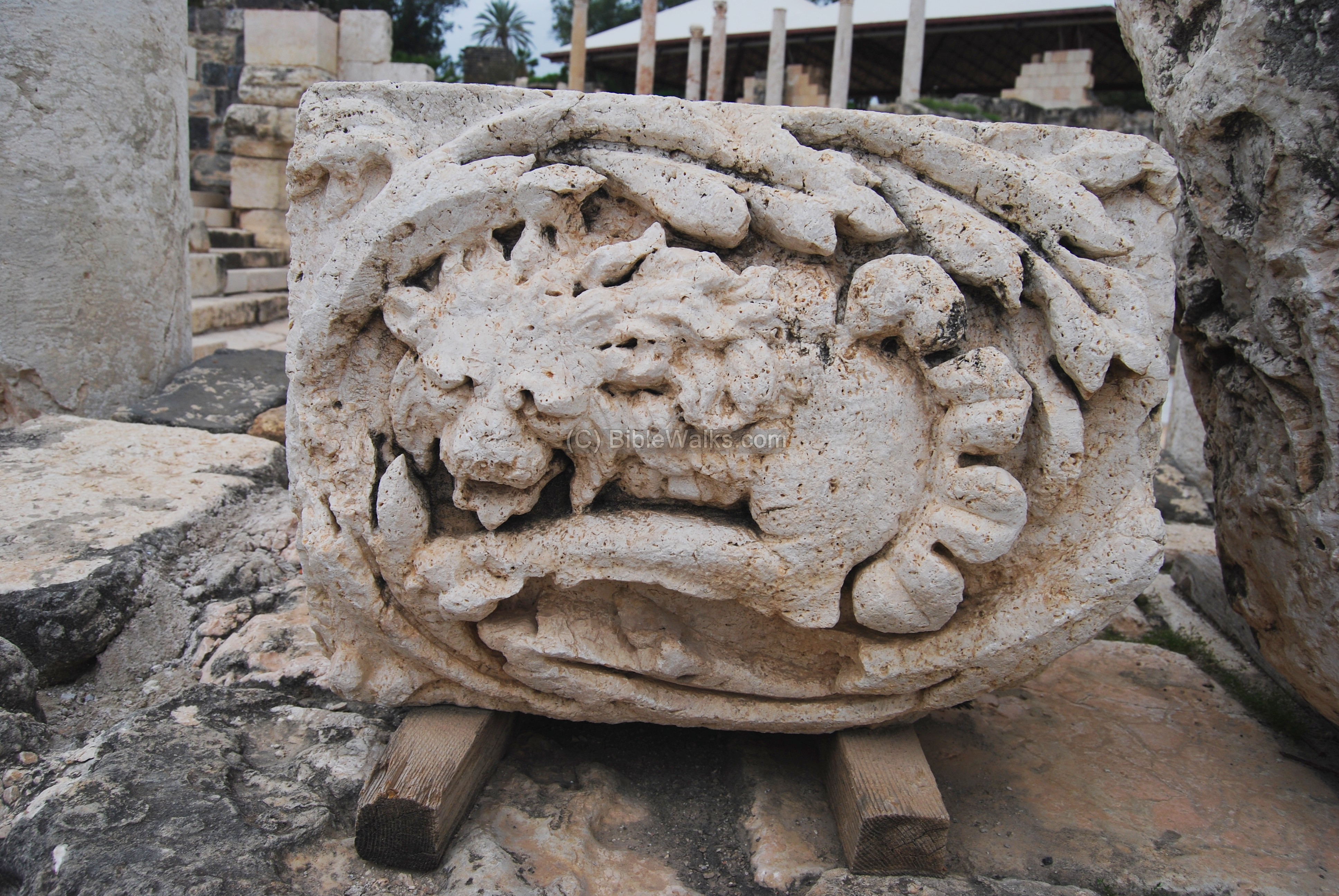
Another sculptured capitol is seen below.
Another lion is depicted in the capitol below.
(d) Western Bathhouse
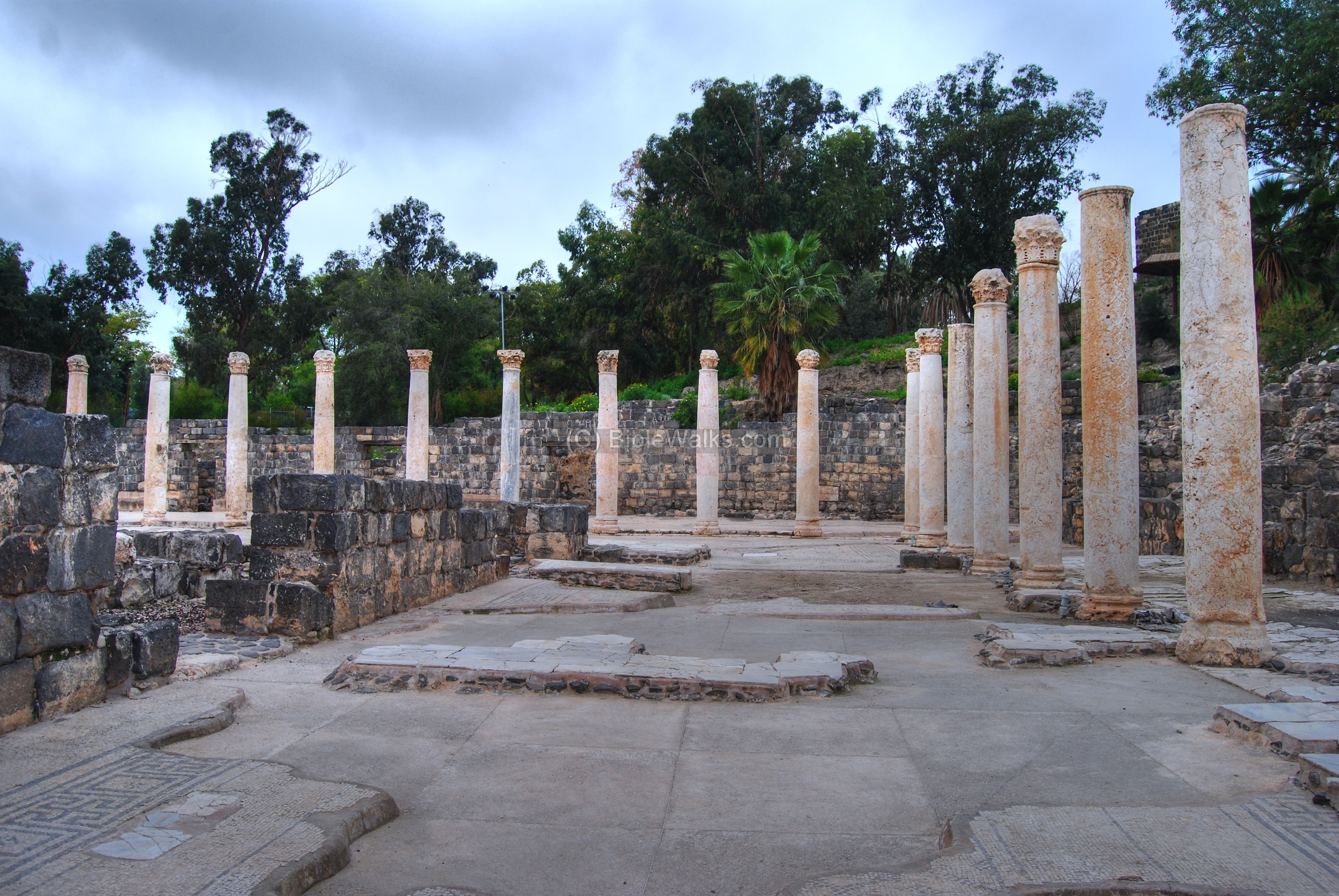
Along the Palladius street, on the south-western side, is a large bathhouse, covering 9 Dunams. Its colonnaded south-west corner is seen below.
The bathhouse included hot and tepid bathing halls. The heating was based on the Hypocaust method (under floor heating system, based on hot air which was pumped under the floor and heated the waters) . The floor was suspended over brick cones, seen below, where the hot air was pumped.

The outside pool is seen below. The floors are paved with marble slabs and mosaics.
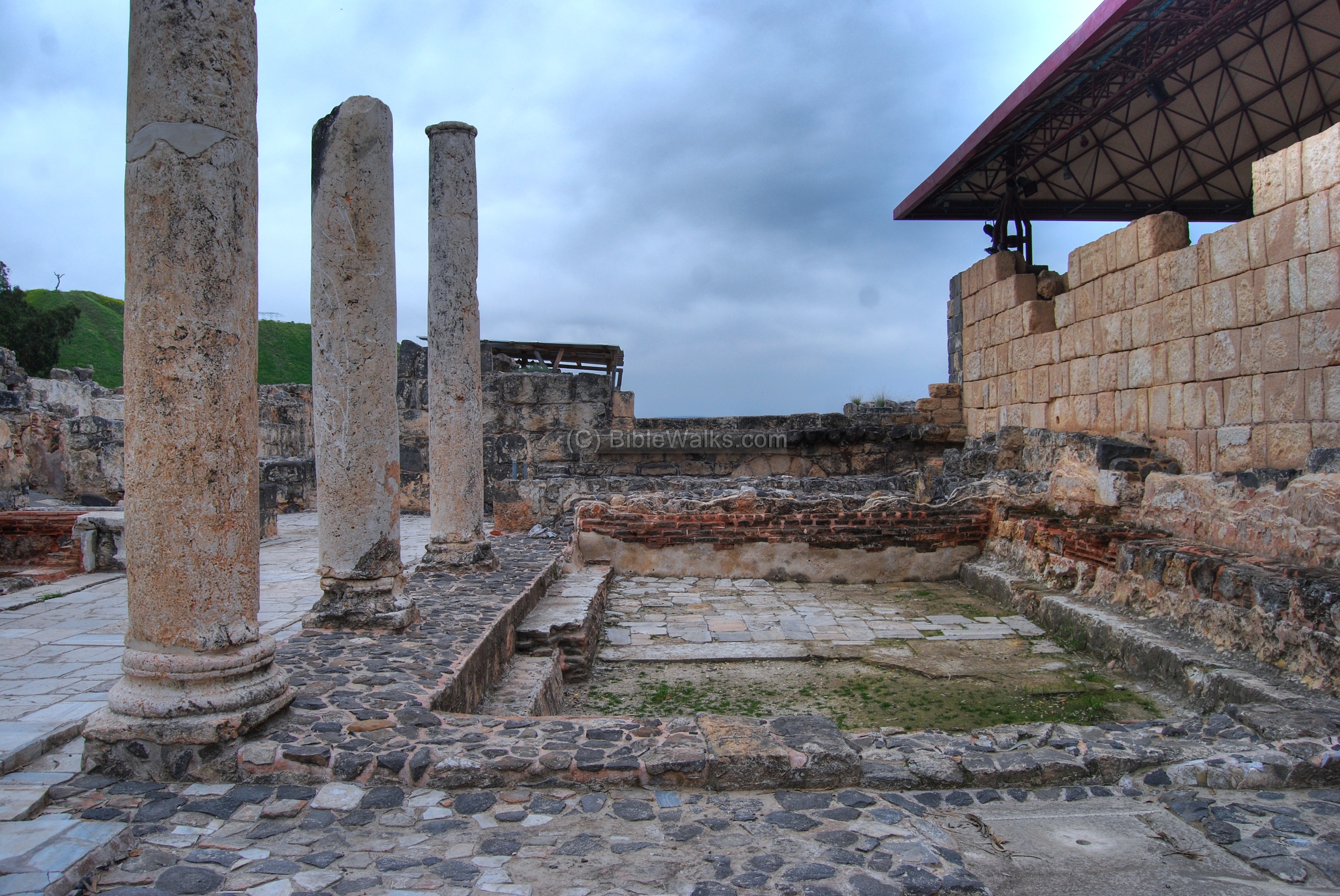
Another section of the western bathhouse is seen below. The structure on the left side is the hall of the public toilets.
The toilets seats were arranged along the walls, and a channel of running water provided drainage.
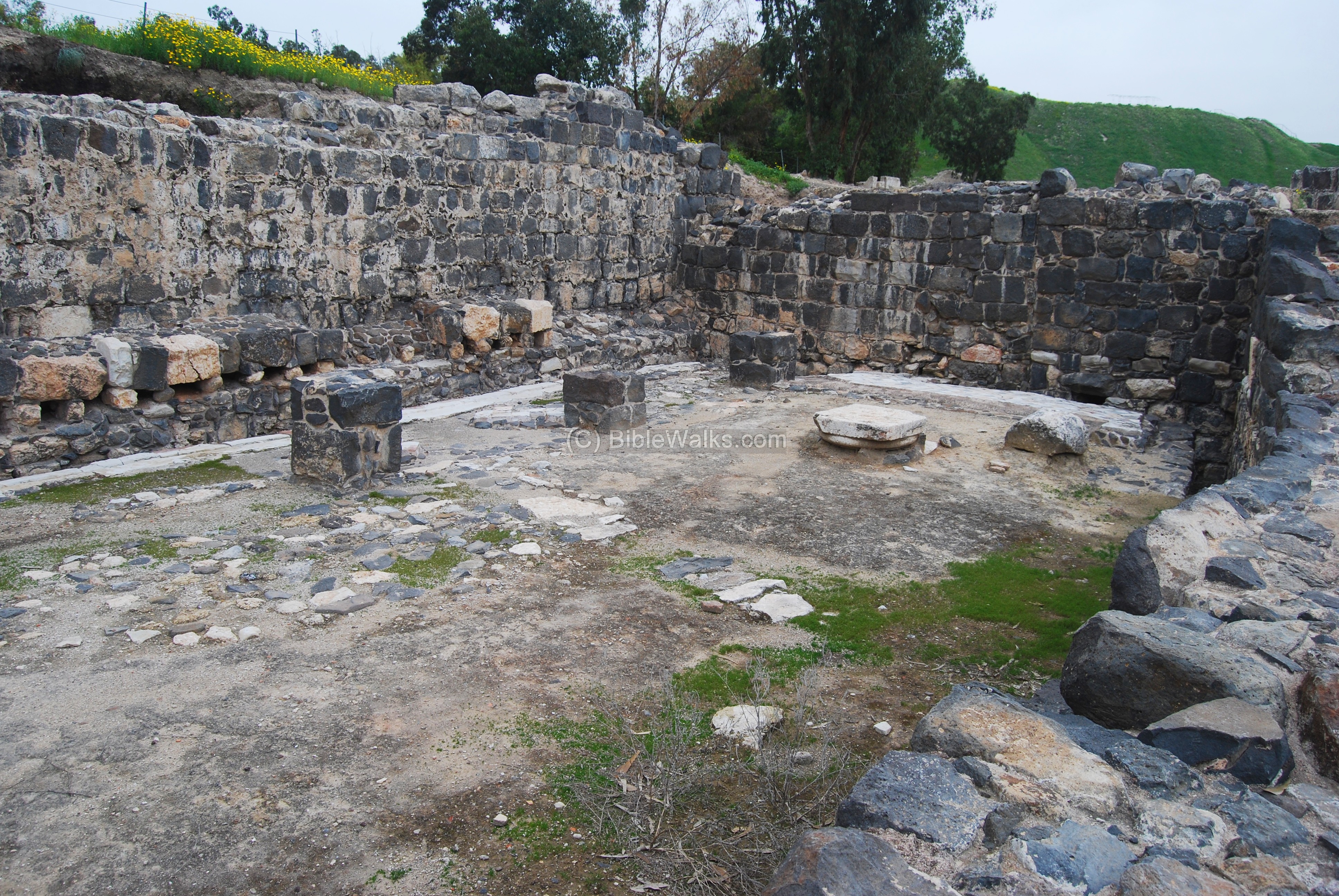
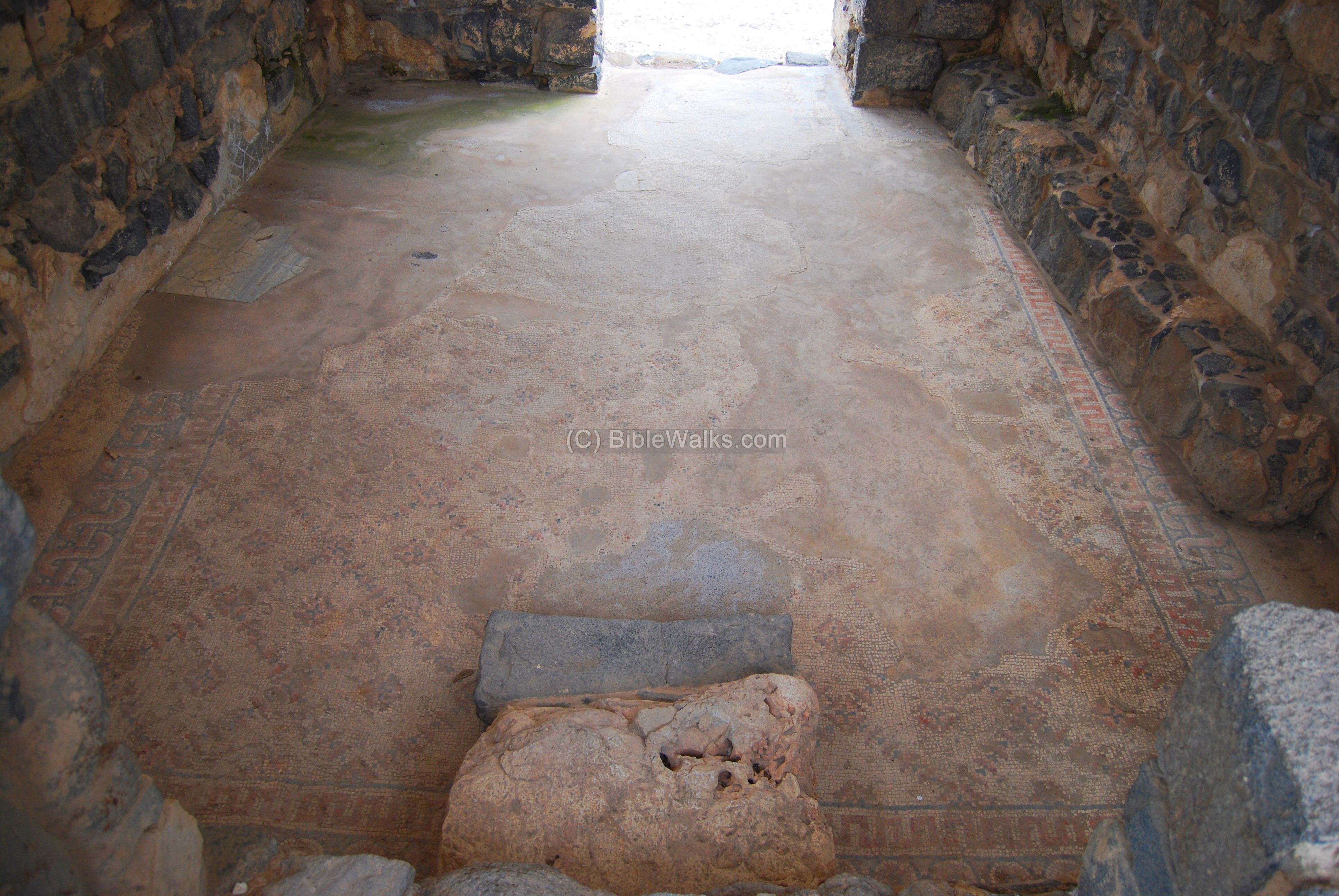
(e) Sigma
The “Sigma” is semicircular area adjacent to the western bathhouse (seen on the right in the photo below) and the Palladius street (seen on the left). The area, dated to the Byzantine period, is surrounded by rooms. It served as a shopping area or the city’s brothel.

The photo below shows one of these rooms, paved with colored mosaics displaying geometric, plant and animal motifs. The name “Sigma” is inscribed in Greek in one of the rooms, giving the area its name.
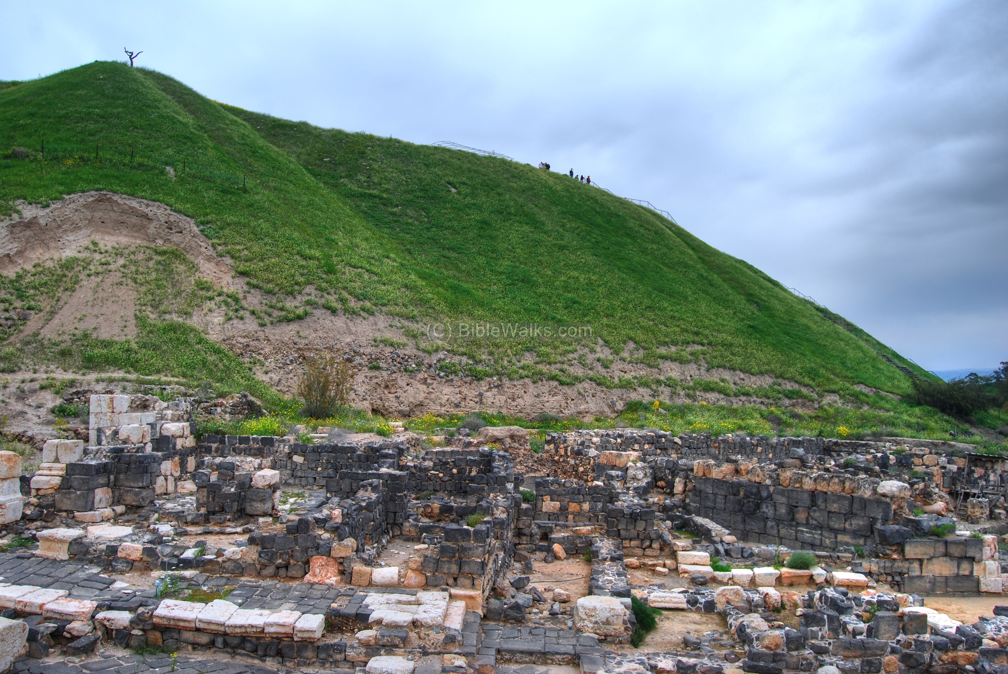
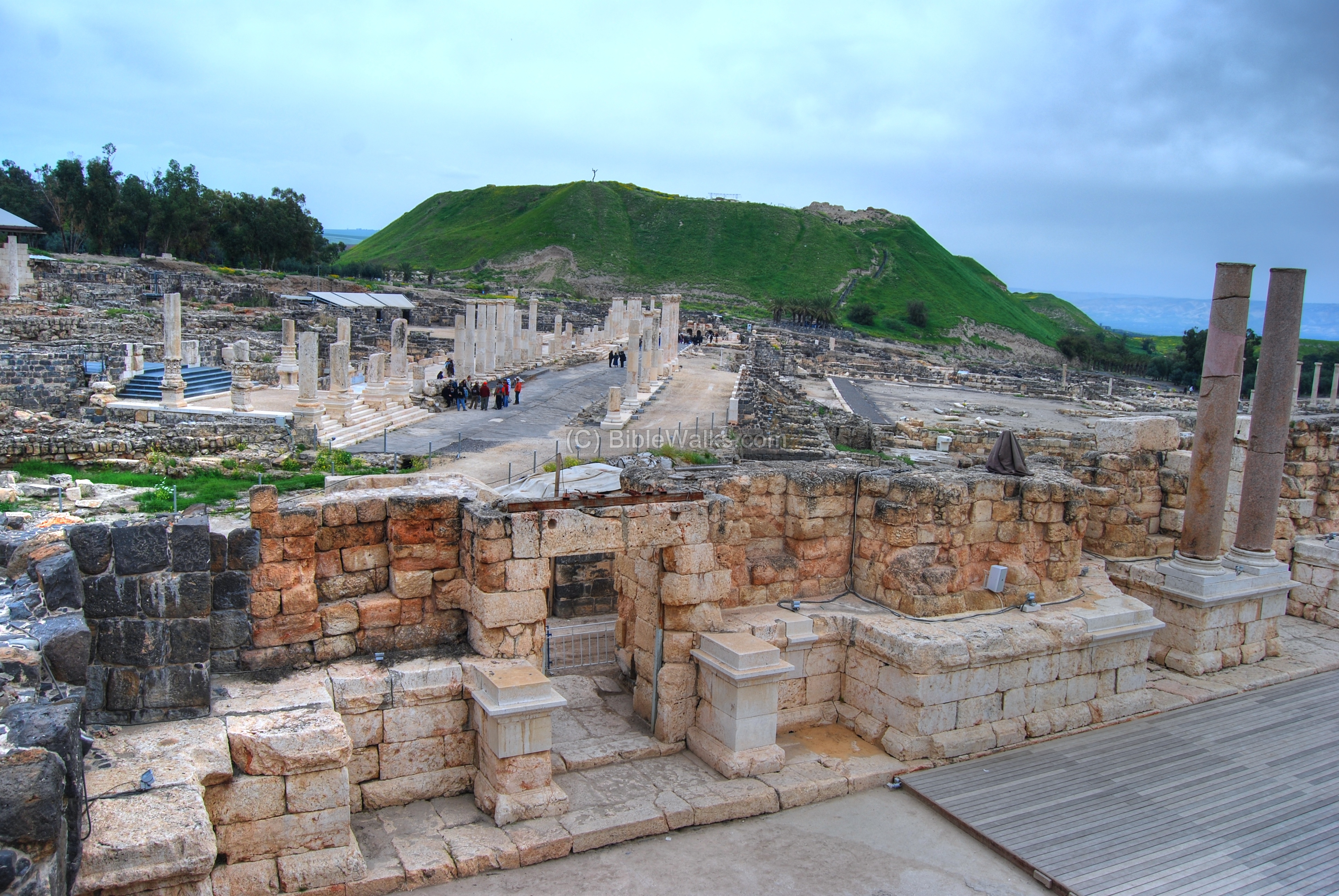
(f) The Tel and the north area
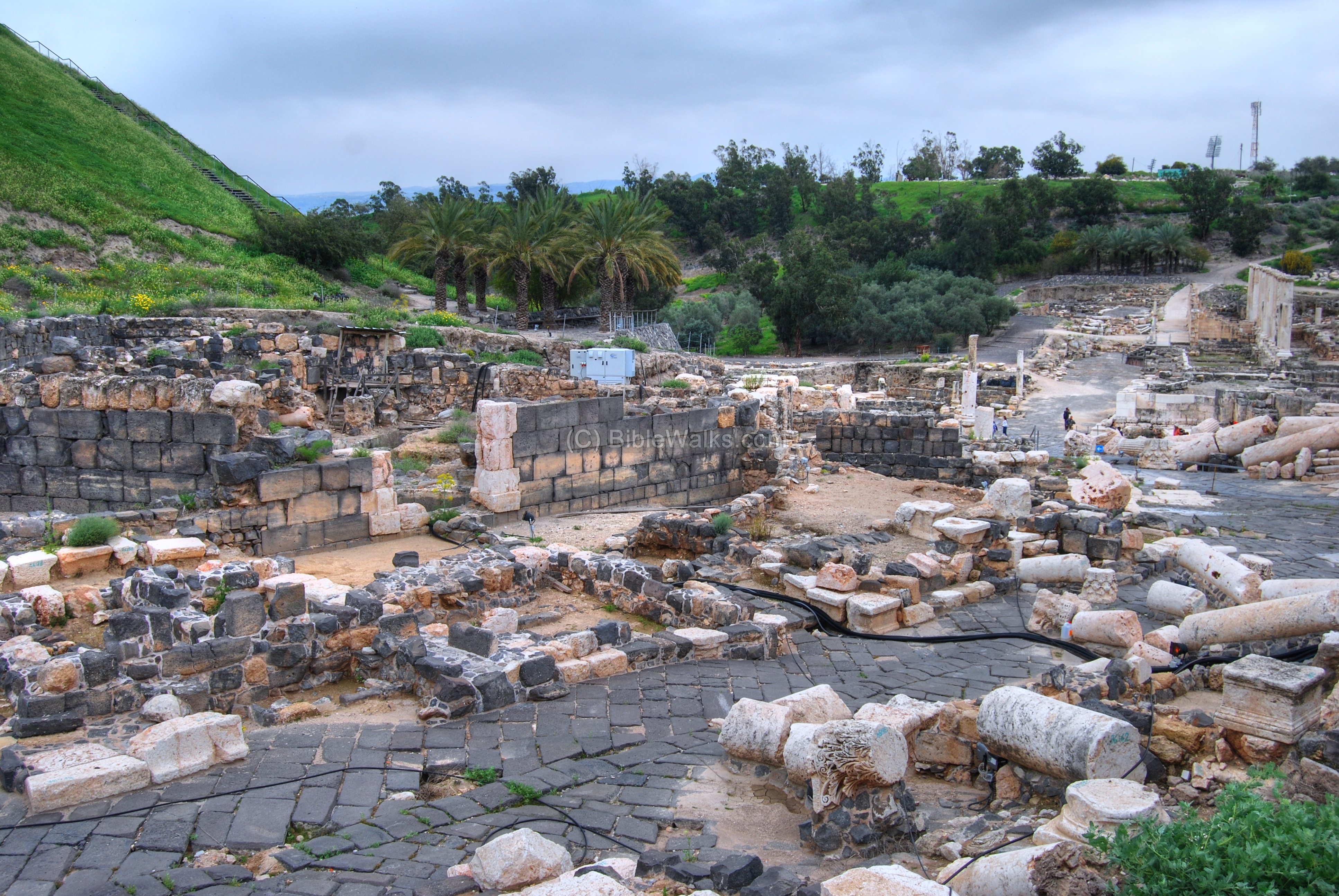
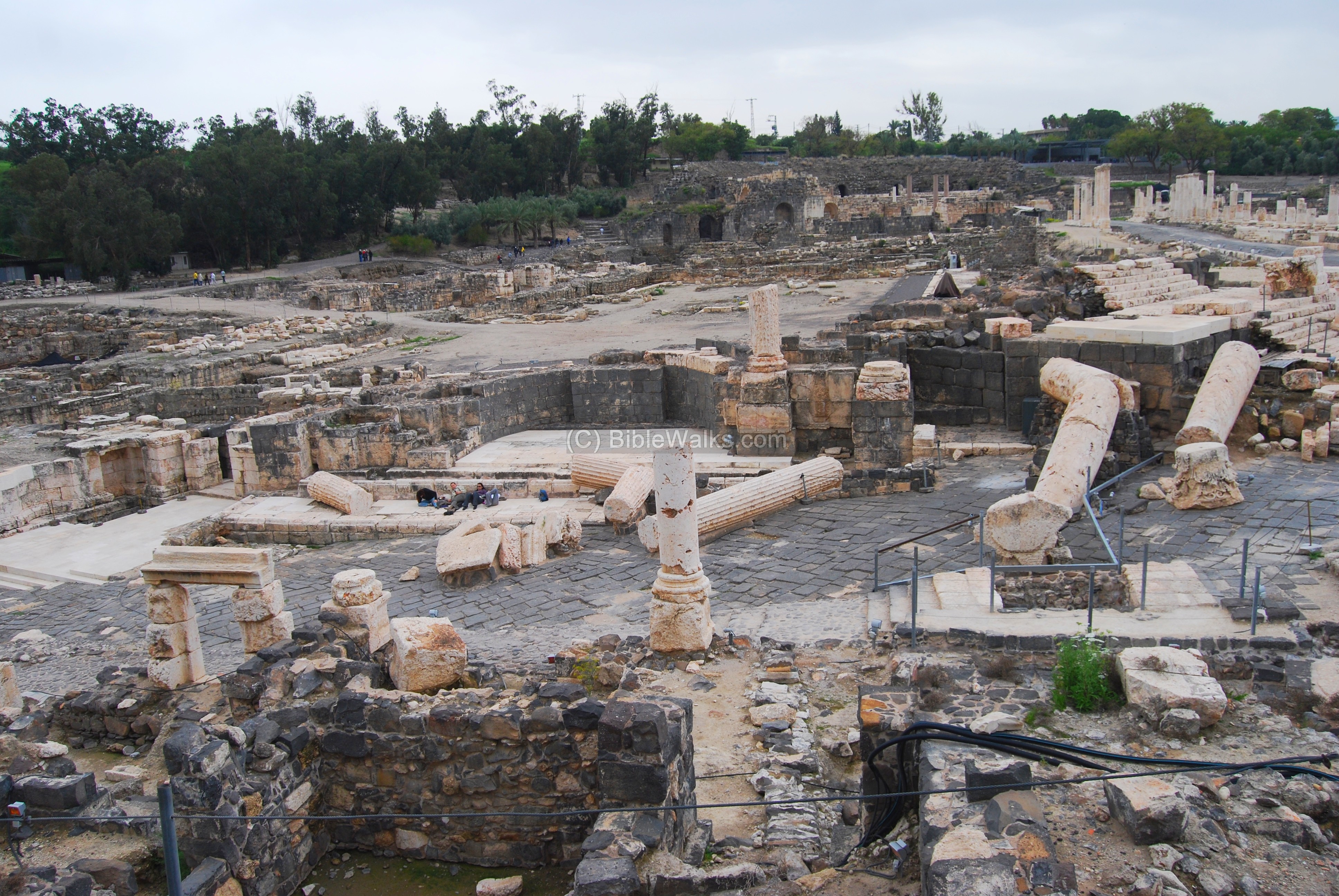
Tel Beit Shean is seen in the photo below. It is 106M under sea level, since the area is located in the Jordan valley depression. The steep hill is 80M above the Harod creek. The Roman civic center is seen in the south foothills of the Tel.
A closer view of the area below the Tel. This was the location of the nympheon, the 2nd century AD water fountain, and other public structures. Large columns lay fallen and broken over the paved street, attesting to the force of the massive earthquake that devastated the city in 749AD.
A model of the nympheon – Roman water fountain – is seen below. The fountain was constructed in the 2nd century AD and reconstructed in the 4th C. The water fell over the two level structure into the pool in its center, facing the street.
Model of the nympheon – courtesy of the national park
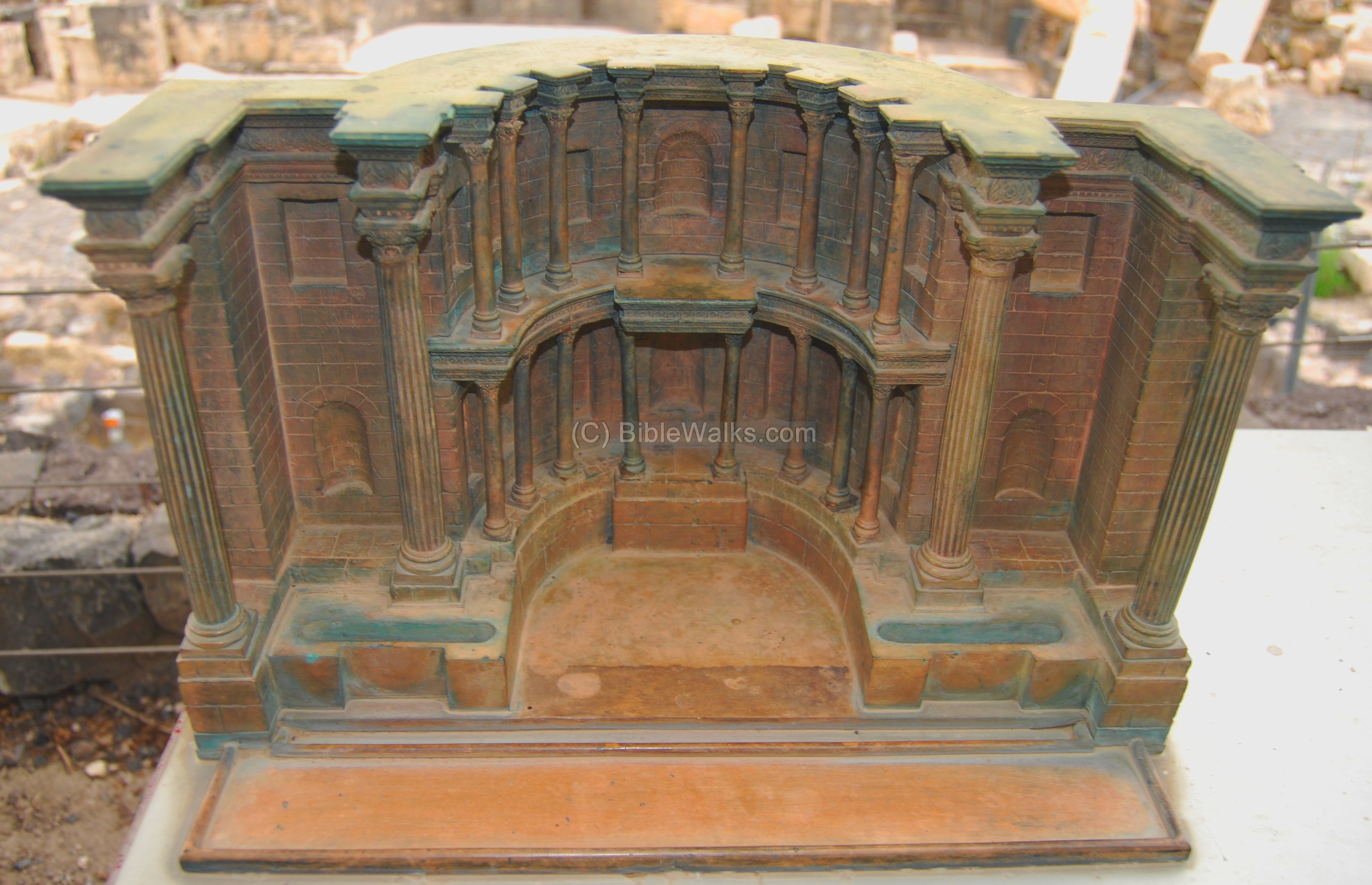
The base of the fountain is seen in the center of the photo below. The full extent of the fountain will be reconstructed in the future, and maybe we will see the water works running once again.
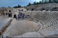
(g) Theater
The theater was built in the 1st century AD. The structure seen today is from the end of the 2nd century, which was used until the 8th century. The theater contained 7,000 seats, arranged in a 110M diameter structure which was cut into the hillside. Only the lower of the three of levels of seats have survived, with 13 rows of limestone seats, as seen in the photo below .
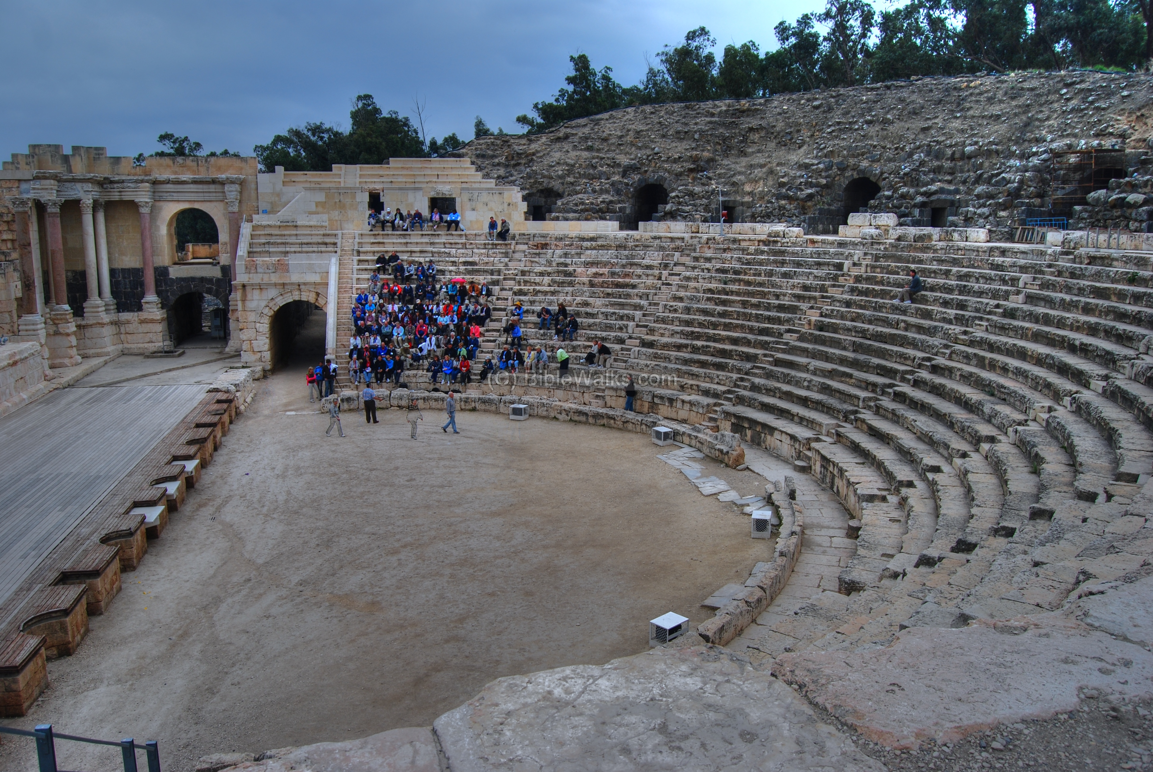
The spectators entered to the theater through the arched entrances. The theater set behind the stage was 20M high.
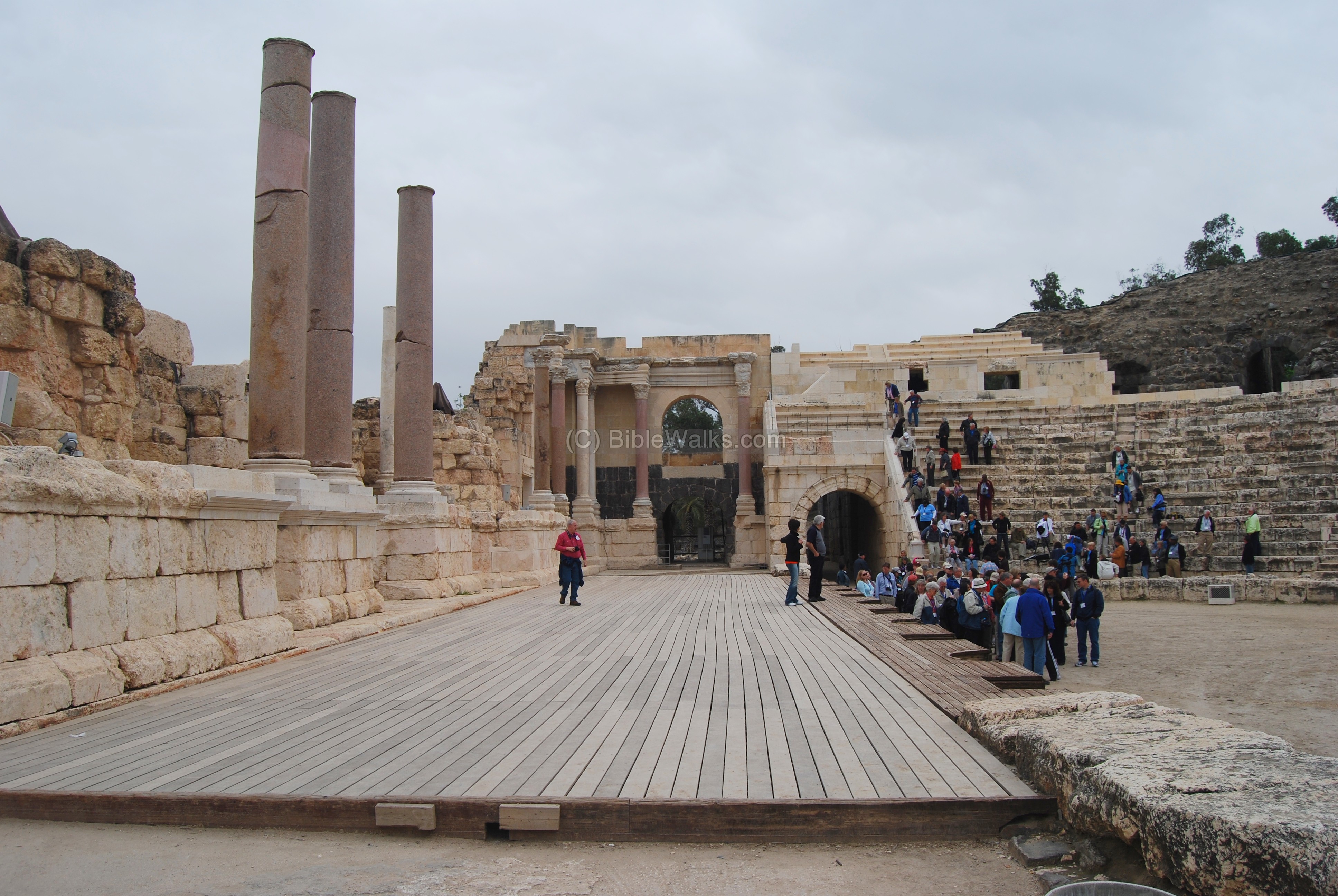
The photo below shows part of the stage, which faced the Biblical Tel in the background.
(h) Tel Iztabba
Tel Iztabba was the northern extension of Tel Beit Shean, and the main area of the Hellenistic city, Scythopolis. This drone view captured Tel Iztabba from the north west side. The Bronze/Iron age Tel Beit Shean is seen behind the valley of the Harod river. Behind it are the ruins of the Roman/Byzantine city, which was accessed from a great bridge seen here inside the Harod valley on the left side.
![]() More on Tel Iztabba on a separate page.
More on Tel Iztabba on a separate page.

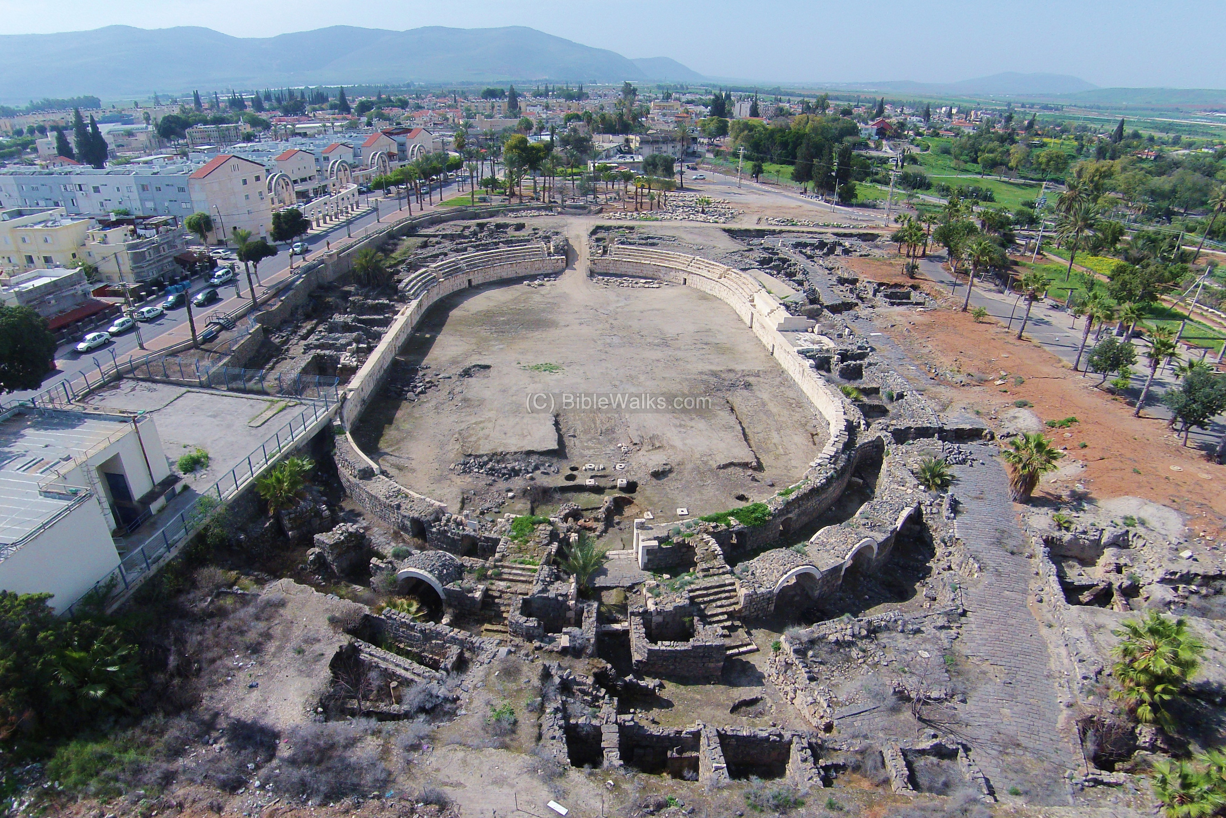
(i) Amphitheater
A Roman hippodrome was constructed in the 2nd century AD, which was used for horse and chariot races. It is located 200m south of the theater, outside of the national park which is seen on the right background. In the 4th Century it was converted into an amphitheater, which hosted hunting displays and entertainment shows. This quadcopter view shows the site from the east side. In the far background is Mt. Gilboa.
(j) Crusaders fortress
In the 12th century the Crusaders built a small rectangular castle east of the Roman city, reusing the stones from the ruins of the city. Beit Shean during the Crusaders times was a small town, first claimed by prince Tancred d’ Hauteville (1075-1112) of Normandy, one of the leaders of the first Crusade.
Its ruins are located on the east side of the modern city, east of the amphitheater and adjacent to the Ottoman period Saraya government house. The Crusader fortress was small – 50m x 50m – with a smaller multi-story keep in its center of 17.3 x 17.3m. The citadel was constructed by local basalt blocks, while the keep was made of limestone blocks removed from the Roman amphitheater.
The base of a corner tower is seen in this photo from the south west side. The bottom side of the wall is of the Crusaders period, while the black basalt stones are from the Ottoman period. The fortress was surrounded by a 14m wide moat filled with water, and a northern draw bridge supported by paired columns separated the citadel from the town.
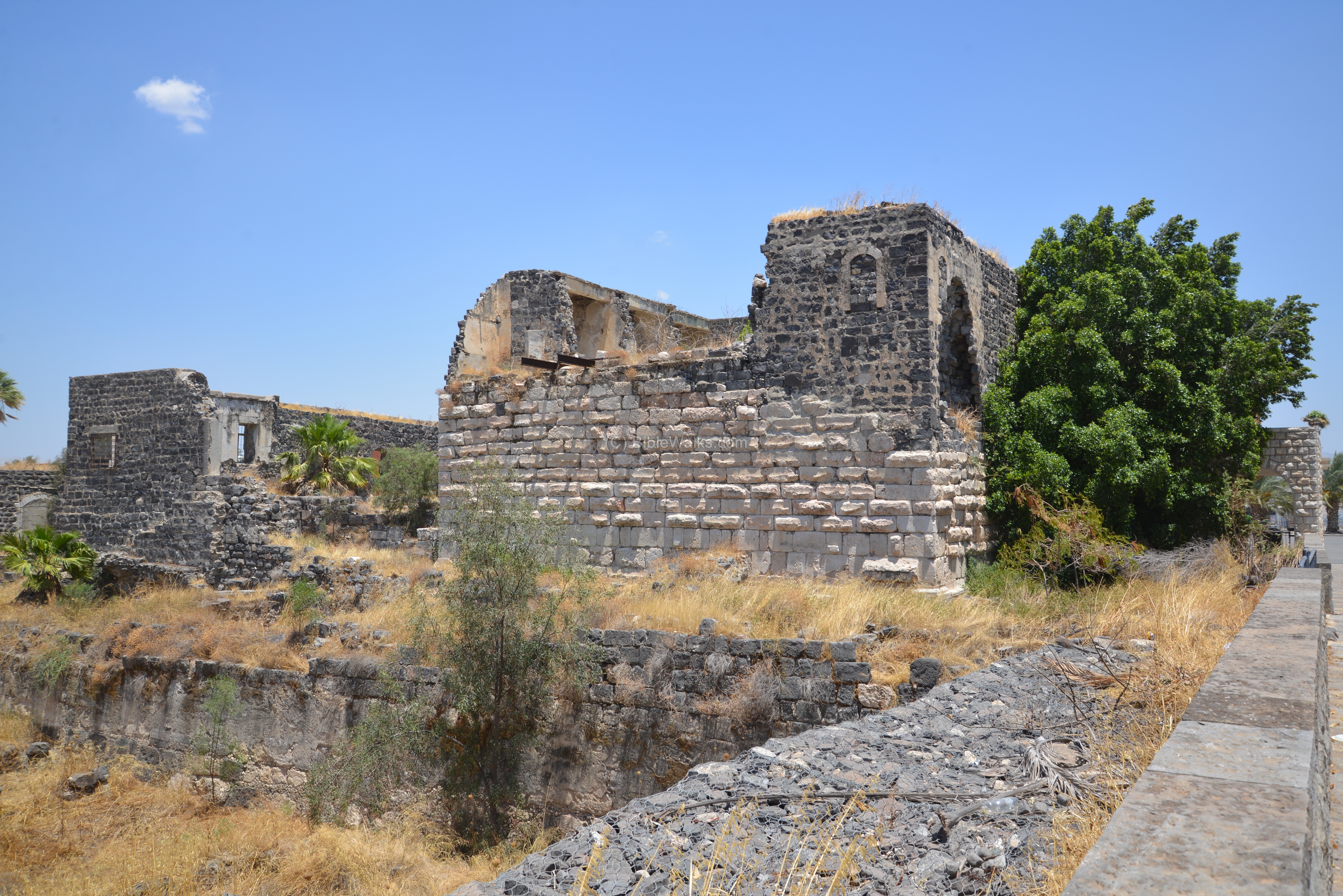
Another view of the ruins, from the north west side, is in the next photo. Remains of the moat and a water trough are seen in the front of the structure.
The Muslim leader Saladin first attempted to capture the fortress in 1182, but was repelled. The fortress was finally captured by the Ayyubid forces, headed by Saladin, in January 1187.

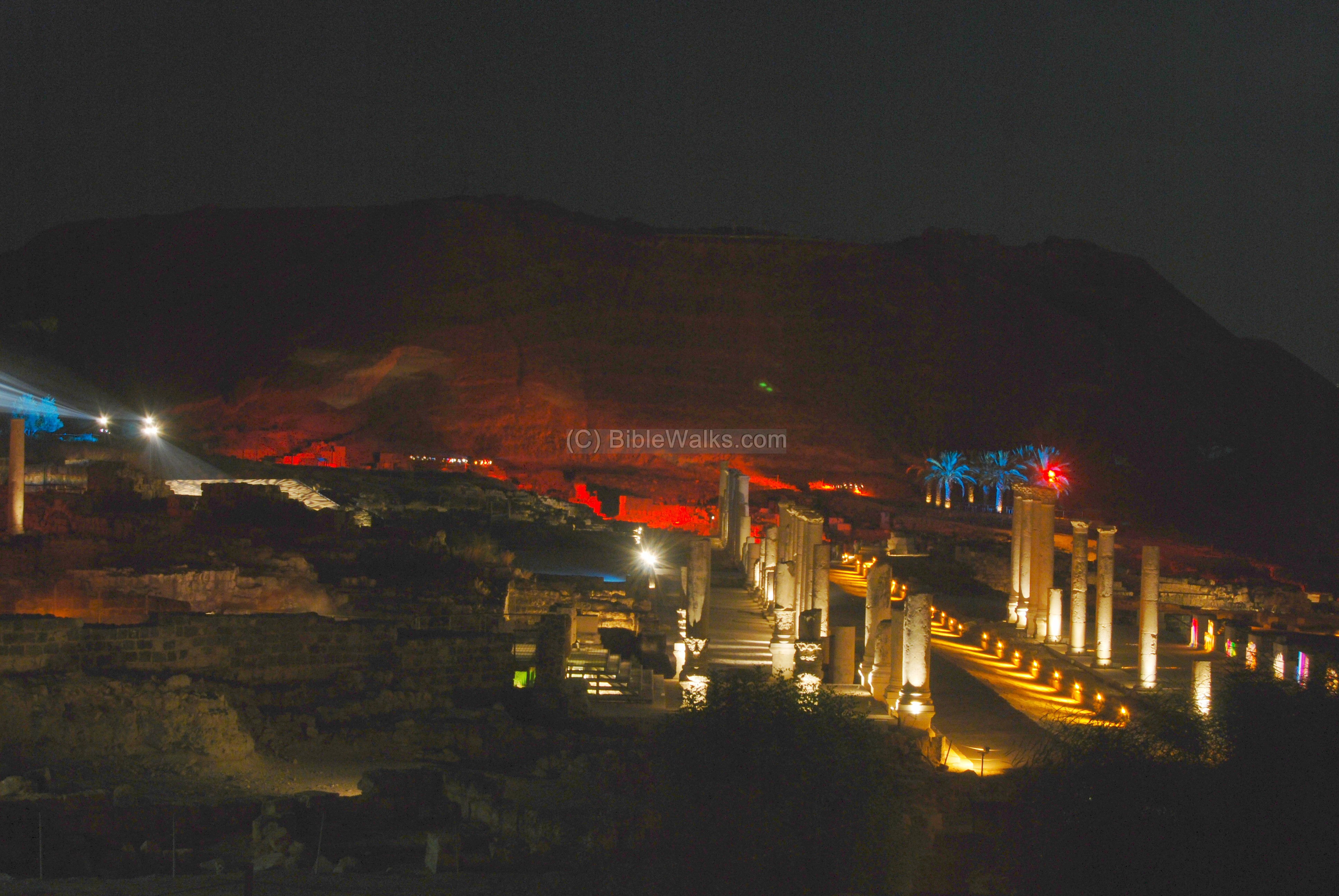
(k) Beit Shean nights
An amazing multi-media multi-sensory night tour has been recently being launched in the national park of ancient Beit Shean.
![]() This night show is covered by a separate page. Don’t miss it!
This night show is covered by a separate page. Don’t miss it!
Biblical References:
(a) Joshua 17: 11-12
The Israelites did not conquer Beit Shean:
“And Manasseh had in Issachar and in Asher Bethshean and her towns, and Ibleam and her towns, and the inhabitants of Dor and her towns, and the inhabitants of Endor and her towns, and the inhabitants of Taanach and her towns, and the inhabitants of Megiddo and her towns, even three countries. Yet the children of Manasseh could not drive out the inhabitants of those cities; but the Canaanites would dwell in that land”.
(b) Judges 1 27-28:
“Neither did Manasseh drive out the inhabitants of Bethshean and her towns, nor Taanach and her towns, nor the inhabitants of Dor and her towns, nor the inhabitants of Ibleam and her towns, nor the inhabitants of Megiddo and her towns: but the Canaanites would dwell in that land. And it came to pass, when Israel was strong, that they put the Canaanites to tribute, and did not utterly drive them out”.
(c) 1 Samuel 31 6-13:
King Saul’s body was displayed on the walls of Beit Shean (here it is spelled BethShan) after his defeat to the Philistines:
“So Saul died, and his three sons, and his armourbearer, and all his men, that same day together. And when the men of Israel that were on the other side of the valley, and they that were on the other side Jordan, saw that the men of Israel fled, and that Saul and his sons were dead, they forsook the cities, and fled; and the Philistines came and dwelt in them.
And it came to pass on the morrow, when the Philistines came to strip the slain, that they found Saul and his three sons fallen in mount Gilboa. And they cut off his head, and stripped off his armor, and sent into the land of the Philistines round about, to publish it in the house of their idols, and among the people. And they put his armor in the house of Ashtaroth: and they fastened his body to the wall of Bethshan. And when the inhabitants of Jabeshgilead heard of that which the Philistines had done to Saul; All the valiant men arose, and went all night, and took the body of Saul and the bodies of his sons from the wall of Bethshan, and came to Jabesh, and burnt them there. And they took their bones, and buried them under a tree at Jabesh, and fasted seven days”.
(d) 1 Kings 4 7, 12:
King Solomon made BeitShean a major administrative city:
“And Solomon had twelve officers over all Israel, which provided victuals for the king and his household: each man his month in a year made provision…
Baana the son of Ahilud; to him pertained Taanach and Megiddo, and all Bethshean, which is by Zartanah beneath Jezreel, from Bethshean to Abelmeholah, even unto the place that is beyond Jokneam:”.
(e) 2 Kings 15:29
The Assyrians captured the Galilee (732 BC), and destroyed Beit Shean.
” In the days of Pekah king of Israel came Tiglathpileser king of Assyria, and took Ijon, and Abelbethmaachah, and Janoah, and Kedesh, and Hazor, and Gilead, and Galilee, all the land of Naphtali, and carried them captive to Assyria”.
Etymology (behind the name):
- Beit Shean (Beth Shean): Hebrew: Beit (Beth) is “House”; She’an may have been a name of an ancient God. Thus, the meaning of the name is “the house of Shean”.
- Scythopolis and Scython-Polis – the Hellenistic city was named after the veterans who resettled the Hellenistic city in 633 BC. Polis – Greek for city.
- Tel – mound (See more on the story of a Tel).
Links:
* More of Beit Shean in other BibleWalks pages:
* Biblewalks info:
-
Roman Streets – in Biblewalks.com
-
Drone Aerial views – collection of Biblical sites from the air
* External:
-
Beit She-an including map
-
Excavation south of the Saraya HA, 2009
-
Beit Shean Museum – Hebrew
-
Islamic and Crusader Beth Shean – from city to settlement – Megan Boomer (pdf)
BibleWalks.com – walk with us through the sites of the Holy Land
Horvat Shamot <<<—previous site—<<< All Sites>>>—next site—>>> Beth She’an at night
This page was last updated on Oct 8, 2024 (add Tel Iztabba page, add PEF map)
Sponsored links: